
NASA - ER-2 High-Altitude Airborne Science Aircraft patch.
April 11, 2017
A NASA ER-2 high-altitude plane has taken to the air to complete phase one of the 11-week GOES-16 Field Campaign to ensure NOAA's GOES-16 satellite provides precise satellite measurements, which will improve forecasting.
The mission? Ensure that NOAA’s GOES-16’s Advanced Baseline Imager (ABI) and Geostationary Lightning Mapper (GLM) instruments are “seeing” the same targets as the plane’s instruments.
Why? Because, to put it simply, GOES-16’s data has to be as well-calibrated and accurate as possible—lives depend on it.
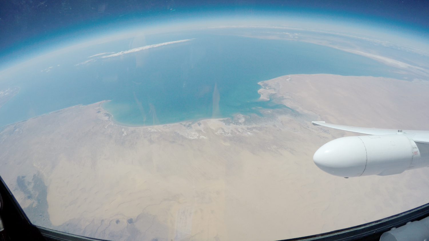
Image above: View from the NASA ER-2 high-altitude aircraft cockpit: Sonoran Desert coastline during ABI validation flight on March 23. Image Credit: NASA.
“Are you seeing what I am seeing?”
Flying out of Palmdale, California, NASA’s ER-2 high-altitude plane and its suite of highly-specialized instruments took to the air over the Sonoran Desert in Mexico (the largest dessert in the Western Hemisphere) and the Mojave Desert in Ivanpah, California on March 23 and 28 to validate GOES-16’s ABI— the satellite’s primary instrument.
The plane made several passes over the large and spatially uniform desert regions, collecting an enormous amount of data and clocking nearly 18 hours of flight time. In a highly-coordinated effort, each time the plane passed over a designated region of desert, scientists used the ABI to perform a series of special north-south scans of the corresponding area.

Image above: Artist rendering of the GOES-R spacecraft with Earth reflecting in solar panel. Image Credit: NOAA.
The plan seems simple enough, right? Collect two sets of data, compare the data, and see how well they match. However, validating a satellite’s imager, especially one as advanced as the ABI, is not so easy.
Before the data from the high-altitude plane and GOES-16’s ABI can be compared and analyzed, scientists must first verify that the plane’s instruments are accurate.
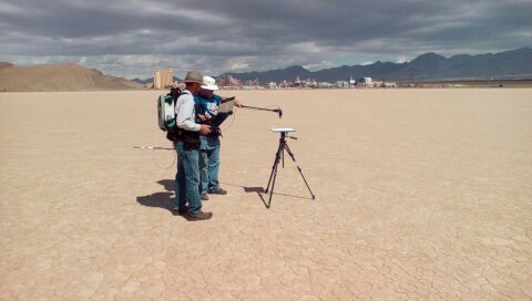
Image above: Scientists check a ground-validation station in Ivanpah, California. Image Credits: NASA JPL.
To do this, two teams of scientists took to the desert to collect data using an array of ground sensors during various segments of the plane’s flight. NOAA even enlisted the help of its own NOAA/NASA Suomi NPP satellite.
Phase one of the field campaign was timed so that the polar-orbiting satellite’s path would intersect with the high-altitude flights. By using proven, operational data from the Suomi NPP satellite and measurements gathered by hand in the desert, scientists were able to ensure that their measuring stick, the NASA ER-2 high-altitude plane, is accurate.
The real trick was doing this all at the same time.
What’s next?
With this complex dance of scientists, satellites, and planes complete and data collected, there is still work to do. Scientists are currently analyzing the data from this first phase while simultaneously preparing for the second phase of the field campaign.
On April 11, NASA's ER-2 aircraft will fly from Palmdale, California to Warner Robins Air Force Base in Georgia. From there, the GOES-R team will initiate the next phase which will occur from April 12 to May 18.
Pilots prepare for high-altitude flight over desert to calibrate NOAA's GOES-16 satellite
Video above: This video shows the view from from the NASA ER-2 high-altitude aircraft cockpit before a flight over the Sonoran Desert coastline during the ABI validation flight on March 23. These flights are conducted in order to validate and calibrate NOAA's GOES-16 satellite. Video Credit: NASA.
During this period the plane will make similar flights over the eastern United States and adjacent oceans to check the data collected by GOES-16’s Geostationary Lightning Mapper instrument. The plane is scheduled to fly in lightning-producing storms over both land and ocean while the satellite monitors them from space.
Previously, during a test flight on March 21, nearly seven hours of data were collected over severe lightning-producing storms east of the San Francisco Bay area. These data were collected simultaneously with ground-based lightning detection networks and a lightning imager on the International Space Station. Similar sensors will be used during phase two to verify the satellite’s data.

NASA ER-2 High-Altitude Airborne Science Aircraf. Image Credit: NASA
NASA successfully launched NOAA's GOES-R satellite at 6:42 p.m. EST on November 19, 2016 from Cape Canaveral Air Force Station in Florida and it was renamed GOES-16 when it achieved orbit. GOES-16 is now observing the planet from an equatorial view approximately 22,300 miles above the surface of the Earth.
GOES-16, one of the GOES-R series of satellites will help meteorologists observe and predict local weather events, including thunderstorms, tornadoes, fog, flash floods, and other severe weather. In addition, GOES-16 will monitor hazards such as aerosols, dust storms, volcanic eruptions, and forest fires and will also be used for space weather, oceanography, climate monitoring, in-situ data collection, and for search and rescue.
Geostationary Lightning Mapper: http://www.goes-r.gov/spacesegment/glm.html
For more information about the GOES-16 Field Campaign, visit:
https://www.nasa.gov/feature/goddard/2017/nasa-participates-in-noaa-goes-16-field-campaign
For more information about the GOES-16 satellite, visit: http://www.goes-r.gov/ or http://www.nasa.gov/goes
Images (mentioned), Video (mentioned), Text, Credits: NASA's Goddard Space Flight Center/Rob Gutro/Karl Hille/National Oceanic and Atmospheric Administration(NOAA)/Kyle Herring.
Best regards, Orbiter.ch