


NASA - Suomi NPP Mission logo / NOAA & NASA - GOES Mission logo / NASA & JAXA - GPM Mission patch.
Sept. 20, 2017
Maria (Atlantic Ocean)
NASA looked into Hurricane Maria and found that powerful convective storms within the hurricane were dropping heavy rainfall. Maria brought that heavy rainfall to Puerto Rico and made landfall on Sept. 20 at 6:15 a.m. EDT.
Satellite Analyzes Rainfall in Hurricanes Maria, Jose
Video above: On Sept. 18, 2017, the Global Precipitation Measurement mission, or GPM, core satellite found rain falling at a rate of more than 6.44 inches (163.7 mm) per hour in powerful storms that reached above 9.7 miles (15.7 km). Shades of green to red represent liquid precipitation extending down to the ground. GPM is a joint mission of NASA and the Japan Aerospace Exploration Agency. Video Credits: NASA/JAXA/NASA Goddard's Scientific Visualization Studio.
The Global Precipitation Measurement mission, or GPM, core observatory satellite collected data on rainfall rates as it passed above Hurricane Maria earlier on Sept. 19 at 9:51 p.m. AST/EDT (Sept. 20 0151 UTC). The rainfall analysis was derived from GPM's Microwave Imager (GMI) and Dual-Frequency Precipitation Radar (DPR) data received by the satellite. GPM's radar (DPR Ku band) found that some extreme storms within the hurricane's feeder bands were dropping rain at a rate of greater than 5.4 inches (137 mm) per hour.
GPM is a joint mission between NASA and the Japan Aerospace Exploration Agency (JAXA).

Image above: NASA-NOAA’s Suomi NPP satellite VIIRS instrument captured this thermal image on Sept. 20, 2017, at 2:12 a.m. EDT (0612 UTC). At the time, Maria’s eye was just east of the American Virgin Islands, and its northwestern quadrant stretched over Puerto Rico. Image Credits: NASA Goddard Rapid Response Team.
NASA-NOAA’s Suomi NPP satellite VIIRS instrument captured a thermal image on Sept. 20 at 2:12 a.m. EDT (0612 UTC). The image showed very cold cloud top temperatures in the powerful thunderstorms in Maria’s eyewall. At the time, Maria’s eye was just east of the American Virgin Islands, and its northwestern quadrant stretched over Puerto Rico.
Landfall in Puerto Rico
The National Hurricane Center noted: “Geostationary satellite images and surface observations indicate that the center of Hurricane Maria made landfall near Yabucoa,
Puerto Rico, around 6:15 a.m. EDT/AST. Maximum sustained winds in the hurricane were reported to be 149.5 mph (130 knots) as Maria moved toward San Juan, Puerto Rico. A sustained wind 60 mph (96 kph) with a wind gust to 113 mph (182 kph) was reported at Yabucoa Harbor, Puerto Rico.”
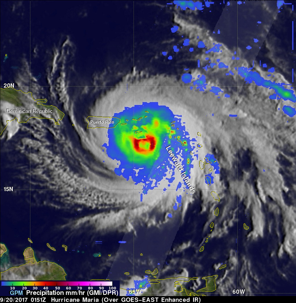
Image above: On Sept. 19, 2017, at 9:51 p.m. AST/EDT GPM's radar found that some extreme storms within the Hurricane Maria's feeder bands were dropping rain at a rate of greater than 5.4 inches (137 mm) per hour. Image Credits: NASA/JAXA, Hal Pierce.
A National Ocean Service tide gauge at Yabucoa Harbor, Puerto Rico, recently reported a water level of 4.3 feet above Mean Higher High Water (MHHW).
Maria Engulfs Puerto Rico in Satellite Imagery
A visible light image of Hurricane Maria was taken from NOAA’s GOES East satellite on Sept. 20 at 10:45 a.m. EDT (1445) as the Category 4 hurricane was moving across Puerto Rico. The island was totally covered by Maria’s clouds. Maria’s eastern quadrant also covered the western half of Hispaniola.
NOAA manages the GOES Series of satellites and images and animations are created at the NASA/NOAA GOES Project at NASA’s Goddard Space Flight Center in Greenbelt, Maryland.
Warnings and Watches
A Hurricane Warning is in effect for the U.S. Virgin Islands, British Virgin Islands, Puerto Rico, Culebra, and Vieques, Dominican Republic from Cabo Engano to Puerto Plata, Turks and Caicos Islands and the Southeastern Bahamas.

Image above: This visible light image of Hurricane Maria was taken from NOAA’s GOES East satellite on Sept. 20, 2017, at 10:45 a.m. EDT (1445) as the Category 4 hurricane was moving across Puerto Rico. Image Credits: NASA/NOAA GOES Project.
A Tropical Storm Warning is in effect for Dominican Republic west of Puerto Plata to the northern border of the Dominican Republic and Haiti, Dominican Republic west of Cabo Engano to Punta Palenque. A Hurricane Watch is in effect for the Dominican Republic from Isla Saona to Cabo Engano.
Status on Sept. 20, 2017
At 11 a.m. EDT (1500 UTC), the center of Hurricane Maria was located inland over Puerto Rico near 18.4 degrees north latitude and 66.5 degrees west longitude. Maria is moving toward the northwest near 12 mph (19 kph), and this general motion with a gradual decrease in forward speed is expected through early Friday, Sept. 22.
Maximum sustained winds are near 140 mph (220 kph) with higher gusts. Maria is a Category 4 hurricane on the Saffir-Simpson Hurricane Wind Scale. Little change in strength is forecast during the next 48 hours, and Maria is expected to remain a dangerous major hurricane through Friday. The estimated minimum central pressure is 930 millibars.
On the forecast track, the center will pass offshore of the northeastern coast of the Dominican Republic tonight and Thursday and then move near the Turks and Caicos Islands and southeastern Bahamas Thursday night and Friday.
For updated forecasts, visit: http://www.nhc.noaa.gov/
GOES (Geostationary Environmental Operational Satellites): http://www.nasa.gov/goes/
Suomi NPP (National Polar-orbiting Partnership): http://www.nasa.gov/mission_pages/NPP/main/index.html
GPM (Global Precipitation Measurement): http://www.nasa.gov/mission_pages/GPM/main/index.html
Images (mentioned), Video (mentioned), Text, Credits: NASA’s Goddard Space Flight Center/Harold F. Pierce/Rob Gutro.
Greetings, Orbiter.ch