
ESA - Mars Express Mission patch.
14 September 2017
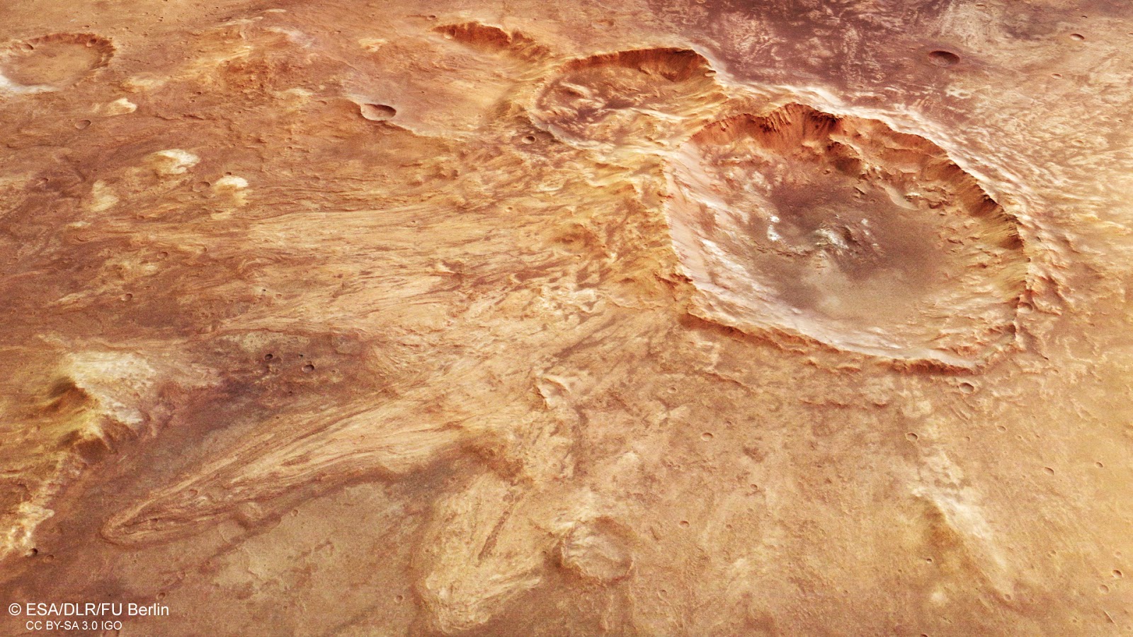
Perspective view
An impactor smashing into an ice-rich surface gave rise to the complex flow features around this ancient crater on Mars.
Impacts of comets and asteroids have shaped the surfaces of rocky planets and moons over the Solar System’s 4.6 billion year history, and can reveal environmental conditions at the time of their formation.

Water-rich impact crater on Mars
During an impact, the energy transferred to the ground goes into melting and vapourising the impactor and parts of the surface, as well as excavating vast amounts of material from the ground, throwing it out onto the surrounding terrain as a blanket of debris.
The characteristics of the ejected material can provide clues as to the conditions of the planet’s surface and its general environment.

Mars Express
The 32 km-wide crater seen centre-stage in this image clearly formed at a time when water or ice was present near the surface. The energy of the impact heated up the water-rich sub-surface, allowing it to flow more easily, leading to the ‘fluidised’ nature of the ejecta blanket.

Topography of a cratered region on Mars
The periphery of the lobes of excavated material often displays a raised ridge: as the flow slowed, the debris behind it piled up, pushing up the material at its periphery into ramparts.

Hellas Planitia and surrounds in context
Many craters on Mars show this pattern, sometimes with multiple layers of ejecta. Here, up to three layers of ejecta lobes can be identified, some of them terminating in ramparts. Multiple layer ejecta deposits can result from a combination of impact into a buried layer of water-rich ground, and interaction of ejected material with the atmosphere.

3D view of a cratered scene north of Hellas
The scene is located north of the Hellas impact basin, one of the largest in the entire Solar System at 2300 km. The region is in an area that is suspected to be the former drainage basin of a lake.
Small channels can also be seen to the south in the main image (left), providing more evidence of the region’s watery past.
Related links:
Mars Express: http://www.esa.int/Our_Activities/Space_Science/Mars_Express
Mars Webcam: http://blogs.esa.int/vmc
Robotic exploration of Mars: http://exploration.esa.int/science-e/www/area/index.cfm?fareaid=118
Mars Express overview: http://www.esa.int/Our_Activities/Space_Science/Mars_Express_overview
Mars Express in-depth: http://sci.esa.int/marsexpress
ESA Planetary Science archive (PSA): http://www.rssd.esa.int/PSA
High Resolution Stereo Camera: http://berlinadmin.dlr.de/Missions/express/indexeng.shtml
HRSC data viewer: http://hrscview.fu-berlin.de/
Behind the lens... http://www.esa.int/Our_Activities/Space_Science/Mars_Express/Behind_the_lens
Frequently asked questions: http://www.esa.int/Our_Activities/Space_Science/Mars_Express/Frequently_asked_questions
Images, Text, Credits: ESA/DLR/FU Berlin, CC BY-SA 3.0 IGO/NASA MGS MOLA Science Team.
Best regards, Orbiter.ch