vendredi 11 février 2011

SDO Celebrates One Year Anniversary


NASA - Solar Dynamics Observatory (SDO) patch.

02.11.11

So Much More Than Pretty Pictures

On February 11, 2010, at 10:23 in the morning, NASA's Solar Dynamics Observatory (SDO) launched into space on an Atlas rocket from Cape Canaveral. A year later, SDO has sent back millions of stunning images of the sun and a host of new data to help us understand the complex star at the heart of our solar system.

"One of the highlights of the last year is just that everything worked so smoothly," says astrophysicist Dean Pesnell, the project scientist for SDO at NASA's Goddard Space Flight Center in Greenbelt, Md. "We turned it on in March and it immediately started sending us data at 150 megabits per second. It worked from the very get go."

One year ago, on February 11, 2010, at 10:23 in the morning, SDO launched into space on an Atlas V-401 from Cape Canaveral. Credit: NASA

The first things scientists and the public saw from SDO was an array of wonderfully detailed pictures of the sun. One of the three instruments on board, called the Atmospheric Imaging Assembly (AIA), captures a shot of the sun every 12 seconds in 10 different wavelengths -- each wavelength helps illuminate aspects of the sun at different temperatures. The images are all available in real time online for everyone to see.

"It's been great to watch how popular these images are," says Phil Chamberlin, another astrophysicist at Goddard and one of SDO's deputy project scientists. "The public has been extremely interested. And it's important that people see what the sun is doing and how it affects us."

Here is one of the first images taken by SDO and still a favorite: A solar eruptive prominence as seen in extreme UV light on March 30, 2010 with Earth superimposed for a sense of scale. Credit: NASA / SDO

These images have regularly caught solar flares, coronal mass ejections, filament eruptions and other space weather phenomena in the act. Such images are helping to flesh out such questions as why the sun's corona – its atmosphere – is thousands of times hotter than the surface of the sun. For example, given how quickly SDO takes its pictures, scientists were recently able to track plumes of plasma heating up as they moved from the sun's surface up into the corona.

Another fruitful area of research from SDO involves understanding the massive explosions on the sun's surface called solar flares. Scientists have been able to use the GOES spacecraft to look at X-rays emitted from solar flares for some 40 years. But observing them in X-rays means one can only see those parts of the flares that are about 10 million degrees Celsius. Other spacecraft have since shown the flares in other wavelengths, but SDO's ability to provide detailed images of the same event in so many wavelengths allows one to see different parts of the flare no matter what temperature. It now appears that flares may be more complex than previously known.

The other two instruments onboard SDO also have made a strong impact. The Extreme Ultraviolet Variability Experiment (EVE) examines the extreme ultraviolet photons from the sun that are responsible for heating in Earth's upper atmosphere. The Helioseismic and Magnetic Imager (HMI) observes how the magnetic fields across the surface of the sun change, as well as seismic activity across the sun. "These are the doorway to the interior of the sun," says Pesnell. "This is how we understand what's going on inside it."

Artist's concept of the Solar Dynamics Observatory. Credit: NASA / Goddard Space Flight Center Conceptual Image Lab

One of SDO's greatest successes so far may be how well these three instruments coordinate with other spacecraft observing the sun. For example, the two STEREO spacecraft moved into position on opposite sides of the sun on February 6, 2011 and will continue towards the far side and all the way around again over the next eight years. For that entire time, STEREO and SDO together will offer scientists their first opportunity to watch the entire sun simultaneously. There are many clues that solar weather can be connected over distances up to a million miles, but this will be the first chance to see how flares on one side coordinate with flares on the other.

In addition, sun observers such as the Reuven Ramaty High Energy Solar Spectroscopic Imager (RHESSI) can show the highest energy, highest temperature bursts on the sun. These can be overlaid on SDO's images to get a more comprehensive picture of each individual event. On January 28, 2011, for example, two bursts of plasma jumped out from each side of the sun simultaneously -- an example of unconfirmed theories that such things often happen 180 degrees apart. Luckily, RHESSI caught the same event in its images, offering an unprecedented chance to examine all parts of the bursts at all temperatures.

"It's not just SDO. It's RHESSI, STEREO, SDO's three instruments all together," says Chamberlin. "The whole is much greater than the sum of the individual parts. We've been talking about putting together this great Heliophysics observatory and this really is what we have."

A composite SDO image from Feb. 11, 2011, exactly one year after its launch. The image combines three wavelengths of extreme ultraviolet light. Credit: NASA / SDO

SDO is the first mission in a NASA science program called Living With a Star, the goal of which is to develop the scientific understanding necessary to address those aspects of the sun-Earth system that directly affect our lives and society. NASA Goddard built, operates, and manages the SDO spacecraft for NASA's Science Mission Directorate in Washington.

For more information about SDO, visit: http://www.nasa.gov/sdo.

Images, Text, Credits: NASA’s Goddard Space Flight Center / Karen C. Fox / SDO.

Greetings, Orbiter.ch

Satellites locate seized Italian oil tanker


The Cosmo-SkyMed satellites constellation providers logos.

11 February 2011

The Cosmo-SkyMed satellites, operated by the Italian space agency, have acquired the first images of the Italian oil tanker Savina Caylyn since it was hijacked earlier this week by Somali pirates in the Indian Ocean.

 The Italian flagged and owned MV Savina Caylyn since it was seized in February 8. (Not actual image)

According to the satellite radar images, acquired by Italian space agency (ASI) and e-GEOS on Wednesday afternoon and early Thursday morning, the seized ship is about 330 km off the Somalia coast.

Savina Caylyn tracked by satellites

The 266-m long and 46-m wide vessel was about 800 km west of India when it was attacked on Tuesday. There has been no reported communication with the vessel and no information regarding the 22 crewmembers on board.

The techniques to rapidly locate and track this ship in open waters were developed and are currently operated as part of the MARISS (Maritime Security Service) project funded under ESA’s GMES Service Element.

Savina Caylyn's location on Thursday

MARISS provides pre-operational satellite-based maritime surveillance services for European waters, East Africa, the Caribbean and the Atlantic to support maritime law enforcement, anti-trafficking interventions and to protect shipping lanes.

Through rapid integration of satellite-based vessel detection with conventional information streams, it provides extended surveillance to a range of coast guards, police forces, navies, customs and excise agencies, border guards and intelligence services. The project is led by e-GEOS and has been running since early 2006.

Cosmo-SkyMed satellite

The images and the extracted information on the vessel are fed directly by e-GEOS into the command and control system of the Italian Coast Guard who received the initial alert when the piracy attack occurred and are now maintaining contact with the vessel owners’ company security officer.

The tanker's location on Wednesday

Dino Quattrociocchi, e-GEOS manager of the MARISS project, said: "This demonstrates our rapid response to such situations as well as our capability to track vessels far outside the coverage of conventional coastal surveillance systems.

"Thanks to the fast update times between successive overpasses by the Cosmo-Skymed satellites, we were able to acquire imagery very soon after the initial request for information on the vessel."

According to Dario Cau and Walter Conti, both working at the Italian Maritime Rescue Coordinate Centre Headquarters in Rome, "the satellite imagery represent a useful capability to track the vessel in open waters as well as providing important information on what is happening in the region around the hijacked vessel."

In depth:

GMES: http://www.esa.int/esaLP/LPgmes.html

MARISS: http://www.gmes-mariss.com/

COSMO-SkyMed: http://envisat.esa.int/object/index.cfm?fobjectid=5384

e-GEOS: http://www.e-geos.it/

Text, Images, Credits: ESA / COSMO-SkyMed images ASI, 2011- processed and distributed by e-GEOS.

Best regards, Orbiter.ch

A Nebula by Any Other Name


NASA - Wide-field Infrared Survey Explorer (WISE) patch.

11.02.2011


Nebulae are enormous clouds of dust and gas occupying the space between the stars. Some have pretty names to match their good looks, for example the Rose nebula, while others have much more utilitarian names. Such is the case with LBN 114.55+00.22, seen here in an image from NASA's Wide-field Infrared Survey Explorer, or WISE.

Named after the astronomer who published a catalogue of nebulae in 1965, LBN stands for "Lynds Bright nebula." The numbers 114.55+00.22 refer to nebula's coordinates in our Milky Way galaxy, serving as a sort of galactic home address.

Astronomers classify LBN 114.55+00.22 as an emission nebula. Unlike a reflection nebula, which reflects light from nearby stars, an emission nebula emits light. Emission nebulae are usually found in the disks of spiral galaxies, and are places where new stars are forming.

The colors used in this image represent specific wavelengths of infrared light. Blue and cyan represent light emitted at wavelengths of 3.4 and 4.6 microns, which is predominantly from stars. Green and red represent light from 12 and 22 microns, respectively, which is mostly emitted by dust.

Images, Text, Credit: NASA / JPL-Caltech / UCLA.

Greetings, Orbiter.ch

jeudi 10 février 2011

ISS Reboost Сompleted


ISS - International Space Station patch.

11.02.2011

In accordance with the International Space Station mission ballistics support program, ISS reboost occured on Feb. 10.

 ISS reboost by Progress cargo spacecraft

The maneuver was assisted by 8 attitude thrusters of the Progress M-07M cargo vehicle attached to the Zvezda instrumentation compartment.

Progress M-07M cargo vehicle arriving at ISS

The engines were started at 00:37:30 Moscow time (21:37:30 GMT). After the burn of 0.5 mps, which lasted 263 sec, the altitude of the station became 0.9km higher, and achieved 352,3 km.

 International Space Station

The operation is aimed at providing favorable conditions for further landing of Soyuz TMA-M crew vehicle scheduled for March 16.

Current ISS On-Orbit Status Report: http://www.nasa.gov/directorates/somd/reports/iss_reports/index.html

For more informations about ISS, visit: http://www.nasa.gov/mission_pages/station/main/

Images, Text, Credits: NASA / Roscosmos PAO.

Greetings, Orbiter.ch

LRO Could Have Given Apollo 14 Crew Another Majestic View


NASA - Lunar Reconnaissance Orbiter (LRO) patch / NASA - Apollo 14 Mission patch.

11.02.2011

Although the Apollo 14 mission to the moon was filled with incredible sights and was completely successful - it met all its science goals - the crew experienced a bit of a disappointment at missing the spectacular view from the rim of a 1,000-foot-wide crater. They might have gazed into its depths if they had the high-resolution maps now available from NASA's Lunar Reconnaissance Orbiter (LRO) spacecraft.

Pressure was on the Apollo 14 mission, launched January 31, 1971, from the start. The Apollo 13 landing had to be aborted because an oxygen tank explosion crippled the spacecraft as it was on its way to the moon. It was a heroic effort just to return the crew safely to Earth, but the Apollo 14 team knew a second failure would probably result in cancellation of the remaining Apollo missions.

 Apollo 14 landing site labeled, picture by LRO

Although nothing as catastrophic as an explosion threatened their mission, the Apollo 14 crew had to improvise their way out of some tense situations. On the way to the moon, the crew had to dock their spacecraft, the Command and Service Module "Kitty Hawk," to the spacecraft that would land on the moon, the Lunar Module "Antares."

However, latches that would lock the two spaceships together refused to engage. Kitty Hawk pilot Stuart Roosa tried the docking maneuver six times over more than an hour and a half before the latches activated, linking the spacecraft so that mission commander Alan Shepard and Antares pilot Edgar Mitchell could transfer to the Antares lander.

Apollo 14 astronaut Alan Shepard playing golf on the Moon (photo-montage, Artist's view)

On the way down in Antares, the crew had to overcome computer and radar glitches in the system that was supposed to guide their landing. Even with the balky guidance system, they were able to pilot Antares to within 87 feet from the targeted landing point, at the time the most precise landing for the Apollo missions.

Apollo 14 Mission patch & Apollo 14 Lunar Module "Antares"

The site, which the crew named the "Fra Mauro Base," was the area to be explored by Apollo 13, a hilly zone about 300 miles from the edge of the 750-mile-wide Mare Imbrium basin formed long ago by the impact of a giant asteroid.

The hills of Fra Mauro were believed to be made of rubble blasted from the Imbrium impact, and lunar geologists wanted the crew to collect rocks from the region so they could accurately date when giant impacts like Imbrium occurred on the moon.

 Lunar Reconnaissance Orbiter (LRO)

Similar massive craters exist on Mercury and Mars, so it appears that the entire solar system experienced a chaotic period of "heavy bombardment" from enormous asteroids. Scientists were keen to date this event because it's very likely Earth was hit as well, and impacts of that scale would alter the evolution of life.

However, on our world, such ancient craters have been erased by erosion from wind and water, as well as the recycling of the crust from its slow motion as a result of plate tectonics.

Moon rocks, Apollo 14 picture

Shepard and Mitchell landed Feb. 5, and they performed two moonwalks, technically called "Extravehicular Activities," or EVAs, one on each day of the two days spent on the lunar surface.

The first EVA went according to plan, with the deployment of the Apollo Lunar Surface Experiments Package, a suite of instruments that included a seismometer to measure moonquakes and laser reflectors to accurately measure changes in the Earth-moon distance using lasers fired from stations on Earth.

During the second EVA, the crew hoped to reach the rim of Cone crater, a more recent impact crater about 1,000 feet wide a little over a mile from the Antares lander.


LROC NAC image (above) of the Apollo 14 landing site acquired 25 January 2011. Close-up showing LM descent stage (right) and ALSEP (arrow), note astronaut tracks between the two landmarks. Credit: NASA / Goddard / Arizona State University.

"An impact crater is like a drill," says Dr. James Rice of NASA's Goddard Space Flight Center, Greenbelt, Md. "The meteorite punches through layers of ground at the impact site and explodes, hurling this material outward. Surface material is scattered farthest, while the deepest material, which usually comes up in big chunks, remains closest to the crater rim.

By collecting rocks as you get closer to a crater, you get a cross-section of the material beneath you without having to dig it up yourself. That's what the Apollo 14 crew did as they approached Cone crater - they wanted to get samples of the layers of rubble from the Mare Imbrium impact and see if Cone crater went deep enough to expose the bedrock beneath.

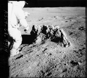
Apollo 14 commander Alan Shepard stands next to a large boulder

The ejecta from the Imbrium impact where Apollo 14 landed may have come from up to 100 miles depth below the original lunar crust." Rice is an associate project scientist for LRO.

However, the terrain was hillier than expected, and the crew lost sight of the crater rim among the ridges of the hills. Eventually, they had to turn back because they needed to save enough oxygen and other supplies to return safely to the lander.

At the time, they estimated they were close enough to the rim that rock samples collected where they stood would still represent the deep layers, but they were disappointed at missing the majestic view from the rim itself.


Using two high-resolution LROC images (above) taken from two separate orbits, we form a stereo image pair for 3D measurements at the Apollo 14 landing site. Among the visible objects are the descent stage of the Apollo 14 lunar module Antares (highlighted with red dot), the Apollo Lunar Surface Experiments Package (yellow dot), a rock nicknamed Turtle Rock (brown dot), and multiple astronaut traverse footpaths clearly indicated by disturbed soils (blue lines). Data processing methods can be used to identify the objects and measure their sizes and shapes. Such 3D measurements and models are used for planning future missions to the moon. Credit: NASA / GSFC / Arizona State University / The Ohio State University. 

High-resolution photos of the area taken with LRO's Lunar Reconnaissance Orbiter Camera (LROC) reveal that they had come within about 30 yards of the rim, just a minuscule distance considering they had travelled over 250,000 miles to get there.

View northeast across the north rim of Cabeus crater (Image credits: NASA / GSFC / Arizona State University)

"The time lost in attempting to determine our exact position for collecting samples in order to satisfy the geologists, cost us significant time. We were essentially at the rim of Cone crater. We just didn't realize how close. It was just out of sight across the next rise a few yards away, when they decided our oxygen and water were too low to do anything but start back," said Antares pilot Edgar Mitchell.

"With the high-resolution photos we have from LRO today, combined with topographic maps made using LRO's laser-ranging instrument, they probably would have made it to the rim, because they would have known exactly where they were every step of the way," says Rice.

LRO has observed all the Apollo sites, and the LRO team is creating lunar maps with unprecedented accuracy that will guide future human and robotic explorers. The maps also will help identify unusual areas for a closer look, according to Rice, because they include data on mineral composition, water ice deposits, rough or unusual terrain, surface temperatures, and temperature changes.

All Apollo's sites by LRO

Still, the Apollo 14 crew did an outstanding job with the maps available at the time, and the mission was a success, with nearly 100 pounds of rocks and soils collected and returned to Earth.

Analysis of the decay of radioactive isotopes in the rocks dated giant impacts like Mare Imbrium at between 3.8 to 3.9 billion years old, about the time when life was emerging on Earth. The mission, which ended when the command module splashed down in the Pacific Ocean Feb. 9, 1971, still holds the record for the longest walk on the moon - approximately 9,000 feet.

LRO was built and is managed by NASA Goddard. The research was funded by NASA's Exploration Systems Mission Directorate at NASA Headquarters in Washington.

Related link: 

http://www.nasa.gov/mission_pages/LRO/main/index.html

http://rst.gsfc.nasa.gov/Sect19/Sect19_6b.html

Smithsonian National Air and Space Museum, Apollo 14 images gallery: http://www.nasm.si.edu/collections/imagery/apollo/as14/a14images.htm

Images, Text, Credits: Credit: NASA / GSFC / Goddard / Arizona State University / The Ohio State University / Space Daily / ROSCOSMOS / Smithsonian National Air and Space Museum.

Greetings, Orbiter.ch

Glory Climate Satellite Ready For California Launch On Feb. 23


NASA - Glory Mission patch.

Feb. 10, 2011

NASA's Glory mission is scheduled to launch Wednesday, Feb. 23, from Space Launch Complex 576-E at Vandenberg Air Force Base in California. Liftoff is targeted for 5:09 a.m. EST (2:09 a.m. PST) in the middle of a 48-second launch window.

Data from the Glory mission will allow scientists to better understand how the sun and tiny atmospheric particles called aerosols affect Earth's climate. Both aerosols and solar energy influence the planet's energy budget – the amount of energy entering and exiting Earth's atmosphere. An accurate measurement of these impacts is important to anticipate future changes to our climate.

The first of NASA's Educational Launch of Nanosatellite, or ELaNa, missions also will be launched on the Taurus XL rocket. These auxiliary payloads are three small satellites called CubeSats, each designed and created by university and college students.

An artist's rendering of the Glory spacecraft. Credits: NASA / GSFC / Ryan Zuber

On Feb. 23, NASA TV coverage of the countdown will begin at 3:30 a.m. EST (12:30 a.m. PST). Liftoff is targeted for 5:09:43 a.m. EST (2:09:43 a.m. PST). Spacecraft separation from the Taurus occurs 13 minutes after launch. The briefings and launch coverage also will be streamed online at: http://www.nasa.gov/ntv

Launch coverage of Glory countdown activities will appear on NASA’s launch blog starting at 3:30 a.m. EST (12:30 a.m. PST). Real-time updates of countdown milestones as well as streaming video clips highlighting launch preparations and liftoff will be available at: http://www.nasa.gov/glory

Taurus XL rocket launch. Credit: NASA

NASA's Goddard Space Flight Center in Greenbelt, Md., manages the Glory project. Mission launch management is the responsibility of NASA's Launch Services Program at the Kennedy Space Center in Florida. Orbital Sciences Corp. of Dulles, Va., which built the Glory satellite, also is the launch service provider of the four-stage Taurus XL rocket.

For more information about NASA and agency programs, visit: http://www.nasa.gov

Images. Text, Credit: NASA./ GSFC / Ryan Zuber.

Cheers, Orbiter.ch

Russia’s Space Ambitions


Moon, Mars and Beyond Exploration.


10.02.2011

After the International space station stops its activities, Russian researchers suggest using it as a basis for a high-latitude orbital space station.

Alan Chinchar's 1991 rendition of the Space Station Freedom in orbit, a step for Moon and Mars Exploration

Authors of the concept believe that such a station could be built between 2020 and 2030. New station will be located at a specific orbit, which provides more intensive research and experiments for Russia’s scientific and industrial benefit. When such station would appear in space, it can be used as a basis for an orbital assembly and experiment complex, which primary, but not the only one mission will be providing space and facilities for scientific research. Another possible application of this complex can be commercial facilities for prolonging lifetime of satellites on their orbits, as well as assembly of spaceships, heading for the Moon and Mars.

Moon Base, painting  by Phil Smith

As for the Moon, Russian researchers suggest starting a 12-year-long moon exploration programme (2025-2036), which will have several stages with first being a placement of an orbital station on a near-moon orbit, and the last – construction of a permanent base on the surface of the Earth’s natural satellite.

Lunar orbital station can be built within two years of 2025 and 2026. The facility can shelter a crew of four cosmonauts. Later on a first-stage base will be built at the Moon’s surface, which is aimed at hosting two-week-long manned missions to the satellite. A second-stage lunar base is scheduled to appear in 2035-2036 – this facility will help start using lunar resources and prepare for industrial use of natural treasures of Earth’s natural satellite.

A variety of lunar orbital stations (Credit: NASA)

MarsIn order to realize abovementioned ambitious plans, Russian researcher will need to develop and build manned space vehicles, cargo spaceships, a module of a lunar orbital station, a module for a lunar base, and an interorbital tug. Elements of a lunar exploration network will be orbited by means of Russian “Angara” and “Rus-M” carrier rockets, as well as a new multiuse space rocket, which are expected to be built by 2025. All launches will be performed from a new launching site Vostochniy, located in the Amur Region.

Scientists from Khrunichev centre, the major Russian enterprise of space and rocket industry, have developed preliminary suggestions on composition, technical appearance, main characteristics, and development order of launching facilities for the manned Lunar and Martian exploration missions.

Mars exploration, first step (Artist's view by ESA)

The concept, developed by Russian researchers, also provides unification of space facilities, used for manned Lunar and Martian exploration missions. In other words, habitable module of lunar and Martian missions, as well as components of a living module of a Moon-orbiting station and an interplanetary habitable module of the Martian programme will be reused. Researchers also plan to build a take-off and landing spaceship for 4 crewmembers, able to carry 40 tons of useful load, a cargo landing spaceship, and a return vehicle.

 VASIMR-powered mission concepts could get crews from Earth to Mars in 39 days (credit: Ad Astra Rocket Company)

A manned space vehicle, built after 2037, will deliver cosmonauts to the orbit of the Red planet.

Related Link: http://www.russia-ic.com/education_science/science_overview/1280/

Images, Text, Credits: Roscosmos / ESA / NASA / Ad Astra Rocket Company / Alan Chinchar / Phil Smith.

Best regards, Orbiter.ch

Giant Ring of Black Holes


NASA - Chandra X-Ray Observatory logo.

02.09.11


Just in time for Valentine's Day comes a new image (above) of a ring -- not of jewels -- but of black holes. This composite image of Arp 147, a pair of interacting galaxies located about 430 million light years from Earth, shows X-rays from the NASA's Chandra X-ray Observatory (pink) and optical data from the Hubble Space Telescope (red, green, blue) produced by the Space Telescope Science Institute (STScI) in Baltimore, Md.

Arp 147 contains the remnant of a spiral galaxy (right) that collided with the elliptical galaxy on the left. This collision has produced an expanding wave of star formation that shows up as a blue ring containing in abundance of massive young stars. These stars race through their evolution in a few million years or less and explode as supernovas, leaving behind neutron stars and black holes.

A fraction of the neutron stars and black holes will have companion stars, and may become bright X-ray sources as they pull in matter from their companions. The nine X-ray sources scattered around the ring in Arp 147 are so bright that they must be black holes, with masses that are likely ten to twenty times that of the Sun.

An X-ray source is also detected in the nucleus of the red galaxy on the left and may be powered by a poorly-fed supermassive black hole. This source is not obvious in the composite image but can easily be seen in the X-ray image. Other objects unrelated to Arp 147 are also visible: a foreground star in the lower left of the image and a background quasar as the pink source above and to the left of the red galaxy.

Infrared observations with NASA's Spitzer Space Telescope and ultraviolet observations with NASA's Galaxy Evolution Explorer (GALEX) have allowed estimates of the rate of star formation in the ring. These estimates, combined with the use of models for the evolution of binary stars have allowed the authors to conclude that the most intense star formation may have ended some 15 million years ago, in Earth's time frame. These results were published in the October 1st, 2010 issue of The Astrophysical Journal. The authors were Saul Rappaport and Alan Levine from the Massachusetts Institute of Technology, David Pooley from Eureka Scientific and Benjamin Steinhorn, also from MIT.

NASA's Marshall Space Flight Center in Huntsville, Ala., manages the Chandra program for NASA's Science Mission Directorate in Washington. The Smithsonian Astrophysical Observatory controls Chandra's science and flight operations from Cambridge, Mass.

More information, including images and other multimedia, can be found at: http://chandra.harvard.edu

> Read more / access larger images: http://chandra.harvard.edu/photo/2011/arp147/

Images, Text, Credits: X-ray: NASA / CXC / MIT / S .Rappaport et al. Optical: NASA / STScI.

Greetings, Orbiter.ch

mercredi 9 février 2011

CaNoRock: Canadian Students Learn to Launch Rockets - CaNoRock : des étudiants canadiens apprennent à lancer des fusées


CaNoRock Student Sounding Rocket Collaboration patch.

(Article bilingue -Bilingual article)

February 9, 2011

Following a weeklong intensive learning program during which they participated in a daily series of lectures, hands on design and technology development and rocket or balloon launch simulations at Andøya Rocket Range in Norway, 11 Canadian students joined their peers from Norway to successfully launch the third sounding rocket of the CaNoRock project - a partnership between the Universities of Alberta, Calgary and Saskatchewan, the University of Oslo and the Andoya Rocket Range in Norway.

The CaNoRock Student Sounding Rocket Collaboration delivers an exceptional discovery and learning experience to Canadian undergraduate students using practical, hands-on instruction in experimental space science using student-built experiments on sounding rockets.


As a result of contributions from the Canadian Space Agency and the University of Alberta, infrastructure to support the development of a dedicated lab for undergraduate students, such that they will learn to develop their own payloads, is underway at the University of Alberta. The lab will be made available to students at the three participating Canadian institutions. Moreover, the participating professors from each institution have committed to integrate a CaNoRock component into a relevant course.

Over the next two years of the program, CaNoRock participants will have attended credited courses relevant to the program, designed and tested their respective payloads and will have the opportunity to learn how to integrate, launch, monitor and analyze both rocket launch data as well as data from their experiments.

The objective of this program is to use rocket activities as a highly visible talent magnet to attract students, to enhance space related discovery learning through practical hands-on instruction, and to create an exceptional learning experience and environment. Ultimately, CaNoRock will attract undergraduate students and bridge them into space related graduate study or the aerospace industry.

Video is available at this address: ftp://ftp.asc-csa.gc.ca/users/Medias/pub/canorock/ and on YouTube http://www.youtube.com/watch?v=zNTxpSt_o3g

Related links:

http://www.isset.ualberta.ca/index.php/outreach/canorock
http://www.ucalgary.ca/
http://www.usask.ca/
For more informations about CSA, visit: http://www.asc-csa.gc.ca/eng/default.asp

“CaNoRock 1″ Proposed Launch Program - "CaNoRock 1" Programme de lancements

CaNoRock : des étudiants canadiens apprennent à lancer des fusées

Pendant une semaine d'apprentissage intensif, 11 étudiants canadiens ont participé à une série de conférences, d’ateliers de conception et de développement technologiques, d’essais et de simulations de lancement de fusées et de ballons-sondes au centre de lancement d’Andøya en Norvège. Au terme du programme, ils ont réussi, de concert avec leurs pairs de la Norvège, à lancer la troisième fusée-sonde du projet CaNoRock entrepris en partenariat entre les universités de l'Alberta, de Calgary et de la Saskatchewan, l'Université d'Oslo et le centre de lancement d’Andøya en Norvège.

Le projet CaNoRock (CaNoRock Student Sounding Rocket Collaboration) offre à des étudiants canadiens de premier cycle une excellente occasion d’enrichir leurs connaissances par le biais d’ateliers pratiques en sciences spatiales expérimentales qui les amènent à construire leurs propres fusées-sondes.

Norway-Canada exchange program students launch experimental rockets in Norway. Norvège-Cannada, des étudiants Canadiens-Norvègiens apprennent à lancer des fusées en Norvège. Photo: Robyn Reist

Grâce à des contributions de l'Agence Spatiale Canadienne et de l'Université de l'Alberta, on mettra en place dans cette université une infrastructure qui permettra d’aménager un laboratoire spécialisé où les étudiants pourront élaborer leurs propres charges utiles. Ce laboratoire sera mis à la disposition des étudiants des trois établissements canadiens participants. De plus, les professeurs de ces établissements se sont engagés à intégrer une composante CaNoRock dans leurs cours.

Pendant les deux prochaines années, les participants du programme CaNoRock pourront suivre des cours crédités, concevoir et tester leurs charges respectives, et auront l’occasion d’intégrer, de surveiller et d’analyser les données de lancement des fusées ainsi que les données de leurs expériences.

Le programme mise sur l’attrait qu’exerce sur les étudiants de premier cycle ce type d’activités à grande visibilité de manière à favoriser l’acquisition de nouvelles connaissances liées à l’espace par le biais de cours pratiques donnés dans un environnement exceptionnel. Au final, le projet CaNoRock servira de tremplin vers des études supérieures dans le domaine spatial ou des emplois dans l’industrie aérospatiale.

Des séquences vidéo sont disponibles à l’adresse suivante : ftp://ftp.asc-csa.gc.ca/users/Medias/pub/canorock/ et sur You tube (anglais seulement): http://www.youtube.com/watch?v=zNTxpSt_o3g

Liens relatif, en anglais seulement :

http://www.isset.ualberta.ca/index.php/outreach/canorock
http://www.ucalgary.ca/
http://www.usask.ca/

Pour plus d'informations sur l'ASC (en français), visitez: http://www.asc-csa.gc.ca/fra/default.asp

Images, Text, Credits: CSA-ASC / CaNoRock / Univ. of Alberta / Univ. of Calgary / Univ. of Saskatchewan / Univ. of Oslo / Andoya Rocket Range in Norway / Robyn Reist.

Best regards, Orbiter.ch

mardi 8 février 2011

NASA Hosting Events For Valentine's Night Comet Encounter


NASA - Stardust-NExT Mission patch.


Feb. 8, 2011

NASA will host several live media activities for the Stardust-NExT mission's close encounter with comet Tempel 1. The closest approach is expected at approximately 8:37 p.m. PST, with confirmation received on Earth at about 8:56 p.m. PST on Monday, Feb. 14.

Stardust-NExT Spacecraft & Comet Tempel 1

Live coverage of the Tempel 1 encounter will begin at 8:30 p.m. Feb. 14 on NASA Television and the agency's website. The coverage will include live commentary from mission control at NASA's Jet Propulsion Laboratory (JPL) in Pasadena, Calif., and video from Lockheed Martin Space System's mission support area in Denver.

A news briefing is planned for 10 a.m. on Feb. 15. Scheduled participants are:

-Ed Weiler, NASA's associate administrator, Science Mission Directorate
-Joe Veverka, Stardust-NExT principal investigator, Cornell University
-Tim Larson, Stardust-NExT project manager, JPL
-Don Brownlee, Stardust-NExT co-investigator, University of Washington, Seattle

Stardust-NExT Spacecraft & Comet Tempel 1 encounter

Mission coverage schedule (all times PST and subject to change):

8:30 to 10 p.m., Feb. 14: Live NASA TV commentary begins from mission control; includes coverage of closest approach and the re-establishment of contact with the spacecraft following the encounter.

Midnight to 1:30 a.m., Feb. 15: NASA TV commentary will chronicle the arrival and processing of the first five of 72 close-approach images expected to be down linked after the encounter. The images are expected to include a close-up view of the comet's surface.

Tempel-1 mapping

This image above shows the composite ITS image of the nucleus with a grid or coordinate system laid over it. The grid helps the science team reference features on the surface. The positive pole is over the horizon at upper right and the longitudes increase according to the right hand rule as defined by the IAU convention. The prime meridian was defined to go through the center of the well-defined crater above the impact site.

10 a.m., Feb. 15: News briefing

Starting on Feb. 9, NASA TV will air Stardust-NExT mission animation and b-roll during its Video File segments. For NASA TV streaming video, scheduling and downlink information, visit: http://www.nasa.gov/ntv

Live commentary and the news conference also will be carried live on one of JPL's Ustream channels. Viewers during events can engage in a real-time chat and submit questions to the Stardust-NExT team at: http://www.ustream.tv/user/NASAJPL2

The public can watch a real-time animation of the Stardust-NExT comet flyby using NASA's new "Eyes on the Solar System" Web tool. JPL created this 3-D environment, which allows people to explore the solar system directly from their computers. It is available at: http://solarsystem.nasa.gov/eyes

This flyby of Tempel 1 will give scientists an opportunity to look for changes on the comet's surface since it was visited by NASA's Deep Impact spacecraft in July 2005. Since then, Tempel 1 has completed one orbit of the sun, and scientists are looking forward to monitoring any differences in the comet.

During its 12 years in space, Stardust became the first spacecraft to collect samples of a comet (Wild 2) in 2004, which were sent in 2006 to Earth for study. The mission is managed by JPL for NASA's Science Mission Directorate in Washington. Lockheed Martin Space Systems in Denver built the spacecraft and manages day-to-day mission operations.

A press kit and other detailed information about Stardust-NExT is available at: http://stardustnext.jpl.nasa.gov

Images, Text, Credits: NASA / UM / Cornell / Peter Thomas and Tony Farnham.

Greetings, Orbiter.ch

Azorean station to track Ariane launch


ESA logo / ESA - ATV2 "Johannes Kepler Mission patch.

8 February 2011

When ATV Johannes Kepler is lofted into space on 15 February, an ESA tracking station on Portugal's Santa Maria island will watch closely, gathering crucial data as Ariane 5 streaks overhead.

In 2008, the Santa Maria station, located five kilometres from the town of Vila do Porto on the Portuguese island of Santa Maria, in the Azores, became the latest station to join ESA's global ESTRACK tracking network. Santa Maria's 5.5 m-diameter antenna provides crucial tracking services for Ariane 5 rockets as they boost Europe's Automated Transfer Vehicles (ATVs) into orbit.

 Santa Maria station

With a total launch mass of some 20 tonnes, including fuel, food and cargo for the International Space station, the ATV vessels are the largest and most sophisticated spacecraft ever built in Europe. The next one, ATV Johannes Kepler, is due for launch on 15 February. It will dock automatically with the ISS eight days later, on 23 February, and remain attached to the Station until June, providing critical orbit reboosts.

Santa Maria: geostrategic location

In order to place ATVs into the correct orbit, Ariane launchers must follow a special flight path that takes them almost directly over Santa Maria island just a few minutes after launch from Europe's Spaceport at Kourou, French Guiana.

Artist's view of ATV Johannes Kepler under Ariane fairing

This particular trajectory made it necessary to set up a specific network of tracking stations to receive real-time data during all critical launch events. For ATV launches, ESA stations provide launcher tracking services to CNES, the French space agency, which oversees the Ariane tracking network.

Santa Maria is one of the first ESA stations that can track a launcher during powered flight, and the geography of the Azores provides an ideal location to acquire signals from launchers climbing northeast from Kourou.

Santa Maria station - view of island landscape

Next week, during the first powered phase, Ariane V200 with ATV on board will pass 130 km above the island and sweep into view of the station's tracking antenna for about eight minutes. During this pass, the station will receive crucial telemetry data via radio containing up-to-the-second information on the status of Ariane's systems such as propulsion, guidance and navigation.

Station is ready for Ariane launch

"We performed a series of technical tests with the Santa Maria station in August and September 2010, followed by a full operational test in January. We are fully qualified for next week's Ariane flight and are looking forward to an intense day with excellent results," said Gerhard Billig, ESA's lead engineer responsible for launcher tracking.

After passing over the Azores, Europe and South-East Asia, Ariane will pass over Australia, where it will be similarly tracked by ESA's 15-m station at Perth and by a station at Awarura, New Zealand.

ATV-2's Ariane 5 flight, lasting about 160 minutes, consists of five consecutive phases:

    * First propulsion phase, over the North Atlantic, from Kourou to the Azores
    * First ballistic phase, over Europe, Central and Eastern Asia, and then Indonesia
    * Second propulsion phase, over Australia and New Zealand to achieve a circular orbit before the ATV separates
    * Second ballistic phase, accounting for one complete orbit around the Earth
    * Third propulsion phase, to the North of Australia, for de-orbiting the launch vehicle upper stage

Note that in 2008, for ATV-1, Ariane tracking made use of a station at Dongarra, Asutralia, whereas ATV-2's ride on Ariane will use ESA's station at Perth instead.

Ariane 5 with ATV-2 launch trajectory

Ariane will loop around Earth, gaining altitude, and make a second pass near Santa Maria, this time at an altitude of 250 km. By this time, ATV will have separated from Ariane, and the launcher will subsequently head toward its planned destructive reentry, which will take place later in its second orbit.

"The Santa Maria station takes advantage of the geostrategic position of the Azorean islands, an important resource for ESA and Portugal – as an ESA Member State – for the implementation of European space projects," said Mario Amaral, coordinator of the Portuguese Space Office.

"We trust the station continues to contribute significantly to ESA and to EU Earth observation programmes, particularly for the Global Monitoring for Environment and Security initiative."

Related Link:

EDISOFT S.A.: http://www.edisoft.pt/

More information:

ATV: http://www.esa.int/SPECIALS/ATV/index.html

Launch vehicles: http://www.esa.int/SPECIALS/Launchers_Access_to_Space/index.html

Europe's Spaceport: http://www.esa.int/SPECIALS/Launchers_Europe_s_Spaceport/index.html

Images, Text, Credits: ESA / D. Ducros / Arianespace.

Best regards, Orbiter.ch