samedi 3 décembre 2011

Europe - The index of habitability


Astrobiology / Exobiology.

12/03/2011

 Europe, Enceladus - The index of habitability (in Russian)

Life beyond Earth is - believe astrobiologists. Moreover, to find its primitive forms to fly away is not necessary. Discoveries of recent years have shown that the oceans are not only water on our planet. Jupiter - Europe - one of the main contenders for habitability. Scientists believe that under the ice cap in Europe is possible biological life.

Europe - Moon of Jupiter (Credit: NASA)

Discoveries of recent years show the oceans of water is not only on our planet. And where the water is, there is life.

Its surface is covered by 100 km long sheet of ice. According to specialists, it was under this ice cap, and there is water.

Vladimir Surdin, senior fellow SAI them. Sternberg: "The evidence as to why Europe can be water, currents, etc. Now no one doubts that there may be water ... "

Ice Sheet Fracturing on Europe, Moon of Jupiter (Artist view by Donato Giancola)

True, the conditions for life on Europa extremes: ice thickness under enormous pressure, there does not get sunlight. One may wonder about what life is all about?

Samples of ice were brought to MSU from Antarctica. 2 million years, these microbes isolated from the outside world, living on half a kilometer deep, at a temperature of minus 20 degrees. They not only survived, but were able to proliferate.

Elena Vorobyov, Senior Researcher, Department of Soil Science, "Life as we know it - this protein life, the concept of stability of life forms, is changed, this is what happened in the last 20 years of research. It was found that on Earth a lot of extreme places in which organisms not only survive, but still functioning in general ... There is resistant to radiation ... "


Image above: Thick or thin ice shell on Jupiter's moon Europe? Scientists are all but certain that Europa has an ocean underneath its surface ice, but do not know how thick this ice might be. This artists' conception illustrates two possible cut-away views through Europe's ice shell. (Credit: NASA / JPL, Artwork by Michael Carroll).

Years of research in the Arctic and Antarctica have shown that even there, at great depths is life.

Elena Vorobyov, Senior Researcher, Department of Soil Science continues: "Now we know that organisms could have arisen without organic matter. Anaerobic organisms that do not require oxygen. They take the energy from chemical reactions, a compound of iron and gas components: hydrogen, carbon dioxide. This is enough to micro-organisms could exist. "

Enceladus - Moon of Saturn (Credit: NASA)

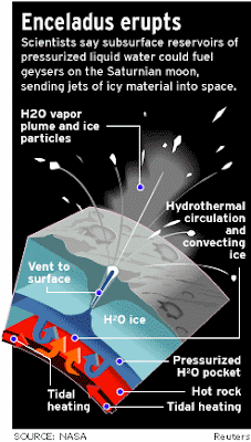
The second candidate on the habitability of Saturn - Enceladus. It has a diameter of 500 kilometers. As well as Europe, it is covered with ice. Moreover, it is a huge crack from which water fountains beat the high tens of kilometers.


Vladimir Surdin, senior fellow SAI them. Sternberg: "The little moon Enceladus is named. It rotates around Saturn, nobody had paid any attention to it, a lot of these satellites. Jupiter 60, Saturn 60 ... recently discovered an amazing thing, under the icy surface of Enceladus, too, there is an ocean, but if Europe should drill, then Enceladus is not necessary, just fly up and take samples of water ... is not that hard ... "

Enceladus Ice Plumes (Artist view by Michael Caroll)

To find the primitive forms of life outside Earth, fly away do not. Almost every planet with its satellite repeats in miniature solar system. The farther away the satellite from the planet, the probability of habitat is reduced.

Enceladus Ice Plumes (Credit: NASA)

The convenient location, in the so-called zone of life, which was once Earth, Europa, Enceladus, has allowed them to keep water in liquid form, and hence the possibility of biological life.

Original text in Russian: http://www.federalspace.ru/main.php?id=2&nid=18374

Images, Video, Text, Credits: Roscosmos PAO / Studio Roscosmos / Roscosmos TV / NASA / Donato Giancola / Michael Caroll / Reuters / Translation: Orbiter.ch.

Greetings, Orbiter.ch

vendredi 2 décembre 2011

ESA's space weather box Proba-2 tracks stormy Sun


ESA - Proba-2 Mission logo.

2 December 2011

Researchers gathered for European Space Weather Week have been presented with the latest results from ESA’s own space weather station: the Proba-2 microsatellite.

The unpredictably stormy Sun drives space weather: surges of charged particles can damage satellites, impede space-based services and affect terrestrial power networks.

An approximately four-week solar rotation tracked by Proba-2

Less than a cubic metre, Proba-2 was launched on 2 November 2009 as a technology demonstrator but is now working as a science mission, having exceeded its two-year design life.

Proba-2 science data are also useful for space weather monitoring: two instruments watch the Sun, with two more studying the Sun’s influence on Earth’s topmost ionosphere. 

The mission is keeping busy: it has gathered upwards of 400 000 images of the Sun and made almost 20 million in-situ ionospheric observations.

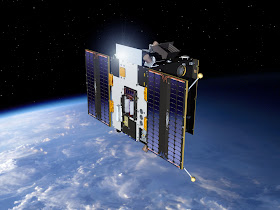
Proba-2

This year’s European Space Weather Week, taking place in the Palais des Congres in Namur, Belgium, from 28 November to 2 December included presentations by users of Proba-2 data from all over Europe.

“Proba-2 science data are also distributed to scientific teams worldwide, from the US to India,” noted Marie Dominique of the Royal Observatory of Brussels, responsible for Proba-2’s Sun-watching sensors.

Sampling space

Rather than being trained on the Sun, some 150 million km away, Proba’s two other main sensors are investigating the immediate vicinity of the microsatellite, circling the poles at an altitude of 700 km.

“Next year, we plan to release the complete processed archive of our results so far,” said Stepan Stverak, of the Czech Republic’s Astronomical Institute.

DSLP instrument

“This dataset will then be available to the scientific community for statistical study, to help identify how ionospheric plasma can be perturbed by solar and space weather events.”

Results will also be cross-checked with France’s Demeter satellite, which sought ionospheric disturbance caused by seismic activity – a potential method of predicting earthquakes.

Proba-2 and Demeter flew in similar orbits before the French satellite ended its mission last year.

New technology taking flight

ESA’s ‘Project for Onboard Autonomy’ family of demonstration satellites allows European companies to test new technologies in space.

Proba-2's cool gas generator

Proba-2’s 17 technology payloads include: a flight computer built around ESA’s latest-generation chip (yet to require a single reset), a fibre sensor ‘nervous system’ monitoring temperatures and fuel tank pressure, and nitrogen gas generators to repressurise the resistojet thruster used for orbit maintenance – giving the mission a new lease of life each time they are triggered.

“The idea behind Proba is to test advanced technologies in a way that the scientific community also finds useful,” remarked Frederic Teston of ESA’s In-Orbit Demonstration Programme.

Fountain of solar plasma

“Gaining the interest of users represents the best proof our technologies work well.”

Proba-2 is designed for maximum autonomy. It is operated by a small team keeping standard office hours, based at ESA’s ground station in Redu, Belgium.

“We work with Redu on a very flexible basis,” Ms Dominique added. “We can easily react if solar activity suddenly changes – in a few hours we change the settings of our instruments, or even the pointing direction of the satellite, for instance, to track coronal mass ejections.”

Related links:

European Space Weather Week 2011: http://sidc.oma.be/esww8/

ROB Proba-2 science centre: http://proba2.sidc.be/index.html/

Proba-2 DSLP data archive at Czech Astronomical Institute: http://terezka.asu.cas.cz/DSLP_dataserver

Proba-2 TPMU data archive at Czech Insitute of Atmospheric Physics: http://www.ufa.cas.cz/html/upperatm/tpmu/TPMU.html

Images, Videos, Text, Credits: ESA / ROB / Academy of Sciences of the Czech Republic / GKN / TNO / APP.

Greetings, Orbiter.ch

What's That Sparkle in Cassini's Eye?


NASA / ESA Cassini Mission to Saturn patch.

Dec.2, 2011

The moon Enceladus, one of the jewels of the Saturn system, sparkles peculiarly bright in new images obtained by NASA's Cassini spacecraft. The images of the moon, the first ever taken of Enceladus with Cassini's synthetic aperture radar, reveal new details of some of the grooves in the moon's south polar region and unexpected textures in the ice. These images, obtained on Nov. 6, 2011, are the highest-resolution images of this region obtained so far.


Video above: NASA's Cassini spacecraft obtained new synthetic-aperture radar views of Saturn's moon Enceladus on Nov. 6, 2011.

The area on Enceladus observed by Cassini's radar instrument does not include the famous "tiger stripes," fissures that eject great plumes of ice particles and water vapor, but covers regions just a few hundred miles away from the stripes. Scientists are scrutinizing an area around 63 degrees south latitude and 51 degrees west longitude that appears to be very rough, a texture that shows up as very bright in the radar images.

"It's puzzling why this is some of the brightest stuff Cassini has seen," said Steve Wall, deputy team lead of Cassini's radar team, based at NASA's Jet Propulsion Laboratory, Pasadena, Calif. "One possibility is that the area is studded with rounded ice rocks. But we can't yet explain how that would happen."


Image above: NASA's Cassini spacecraft obtained these views of the south polar area of Saturn's moon Enceladus in visible and near-visible (ultraviolet and infrared) light and synthetic-aperture radar (SAR). The region is south of 45 degrees south latitude. The SAR image, acquired November 6, 2011, is shown as an arc running from upper left to lower right, accented in light blue. Bright and dark edges of this arc are artifacts of the radar imaging process.

New synthetic-aperture radar views of Saturn's moon Enceladus on Nov. 6, 2011: http://www.nasa.gov/mission_pages/cassini/multimedia/pia15172.html

Scientists are also intrigued by an area around 65 degrees south latitude and 293 degrees west longitude, which shows a close-up view of grooved, water-ice bedrock. The new images reveal undulations and other intricate patterns that had not been seen previously. They also now have measurements of the heights and depths of the grooves in this area, with the central groove measuring about 2,100 feet (650 meters) deep and 1.2 miles (2 kilometers) wide. It has slopes of about 33 degrees.

These images of Enceladus show some similarity to those obtained of Saturn's largest moon Titan. Titan's large feature Xanadu is also very bright, as are areas surrounding the crater Sinlap. Whether the bright areas seen here are due to the same, or very different, processes will be a subject of discussion as scientists continue to learn more about the moons of Saturn.

The Cassini orbiter was designed, developed and assembled at JPL. The radar instrument was built by JPL and the Italian Space Agency, working with team members from the U.S. and several European countries. JPL is a division of the California Institute of Technology in Pasadena. For more information about the Cassini-Huygens mission, visit http://www.nasa.gov/cassini and http://saturn.jpl.nasa.gov .

Image, Video, Text, Credits: NASA / JPL-Caltech / Jia-Rui Cook / SSI.

Cheers, Orbiter.ch

Antarctic ice sheet assures SMOS accuracy


ESA - SMOS Mission logo / CONCORDIA Antarctica Base patch.

2 December 2011

A remarkable ESA campaign in one of the remotest regions on Earth has been fundamental in ensuring that the SMOS mission is delivering reliable data to improve our understanding of Earth’s water cycle.

The two-year campaign set out to answer a simple but important question: do the microwave signals of a particular wavelength emitted from the surface the Antarctic ice shelf towards the SMOS satellite change over time?

Calibration tower, Antarctica

For a satellite mission that maps variations in soil moisture and ocean salinity it may seem strange to try an answer this question from the icy reaches of Antarctica.

The SMOS satellite carries an innovative microwave radiometer that operates around 1.4 GHz (L-band) to capture images of ‘brightness temperature’. 

These images correspond to microwave radiation emitted from Earth’s surface and can be used to derive detailed information about soil moisture and ocean salinity.

SMOS measurement principle

To ensure the mission is delivering accurate data, experiments have to be carried out back on Earth. These involve collecting well-calibrated long time-series of L-band and infrared brightness temperature data on the ground to compare with measurements gathered by SMOS above.

Although challenging for human survival, the campaign site in east Antarctica, called Dome-C, is ideal for these experiments.

Dome-C is notoriously cold with temperatures dropping to a bone-chilling –80ºC, the air is typically very dry, there are very few aerosol particles and the snow and ice cover is flat and uniform.

Installing Radomex

The Italian–French Concordia station in this region offers an extraordinary natural laboratory, attracting scientists from all over the world to carry out research in astronomy, seismology and atmospherics.

The area has been extensively studied, confirming that the emission of microwave radiation from this region is very stable over time. However, most of the work has focused on wavelengths shorter than 5 cm. Until now, there was very little information about the SMOS wavelength of 21 cm.

To answer this need, Italy’s Institute of Applied Physics (IFAC-CNR) developed a microwave radiometer called Radomex and installed it on a tower near the Concordia base.

Comparison of ground and SMOS measurements

The instrument took readings automatically, making it possible to collect data 24 hours a day.

In addition, deep snow pits were dug during the summer months and properties of the snow were recorded. During the winter, extreme conditions meant that this was reduced to taking samples only down to 1 m.

Commenting on the results, Giovanni Macelloni from IFAC-CNR said, “After all this hard work and challenges, we were happy to confirm that microwave emission at vertical polarisation is very stable.

Measuring snow properties

“At the same time small fluctuations in the signal were observed at horizontal polarisation and carefully characterised.”

ESA’s Mark Drinkwater added, “When Dome-C was predicted to fulfil the criteria for a stable natural target for SMOS calibration and product validation, it came at the price of designing appropriate instrumentation to weather the extreme conditions.

“The triumph is that IFAC-CNR built a robust instrument. Its operation demonstrates the stability of thermal Antarctic ice-sheet emission at L-band. Meanwhile, these results justify establishing a long-term capability for SMOS performance monitoring.

Dome-C, Antarctica

“The campaign also highlights the potential of the Concordia base as an ideal natural laboratory for calibrating and validating other multiagency Earth observation satellite data.”

Given unique characteristics of the DOME-C site to support SMOS and an array of additional investigations into future satellite missions, ESA is now planning to support a new multiyear campaign starting in December 2012.

Related links:

IFAC-CNR: http://www.ifac.cnr.it/

Concordia Base: http://www.concordiabase.eu/

PNRA: http://www.pnra.it/

ARPAV-CVA: http://www.arpa.veneto.it/csvdi/

Campaigns at work blog: http://blogs.esa.int/campaignearth/

Access SMOS data: http://earth.esa.int/SMOS/

In depth:

Campaigns: http://www.esa.int/esaLP/LPcampaigns.html

SMOS: http://www.esa.int/esaLP/LPsmos.html

Image, Video, Text, Credits: ESA / IFAC / CNR / AOES Medialab.

Best regards, Orbiter.ch

Mountains and buried ice on Mars


ESA - Mars Express Mission patch.

2 December 2011

 Phlegra Montes on Mars

New images from Mars Express show the Phlegra Montes mountain range, in a region where radar probing indicates large volumes of water ice are hiding below. This could be a source of water for future astronauts.

Phlegra Montes is a range of gently curving mountains and ridges on Mars. It extends from the northeastern portion of the Elysium volcanic province to the northern lowlands, spanning latitudes from roughly 30°N to 50°N.

Phlegra Montes in context

The mountains themselves are probably not volcanic in origin, but have been raised by ancient tectonic forces that squeezed different regions of the surface together.

New images from the high-resolution stereo camera on ESA’s Mars Express orbiter allow a closer inspection and show that almost every mountain is surrounded by ‘lobate debris aprons’ – curved features typically observed around plateaus and mountains at these latitudes.

Previous studies have shown that this material appears to have moved down the mountain slopes over time, and looks similar to the debris found covering glaciers here on Earth.

Phlegra Montes

The suggestion then is that there may be glaciers buried just below the surface in this region. 

This interpretation is backed up by the radar on NASA’s Mars Reconnaissance Orbiter looking beneath the martian surface.

The radar shows that lobate debris aprons are indeed strongly associated with the presence of water ice, perhaps only 20 m down.

Further evidence for relatively recent glaciation can be seen inside impact craters in the region. Series of ridges are thought to have developed when the ancient craters filled with snow. Over time, the snow compacted to form glaciers which then sculpted the crater floors.

Phlegra Montes in elevation

There are yet more glacial flow patterns visible in the valley at the centre of the image.

It is believed that mid-latitude glaciers developed at various times in the last several hundred million years, when the polar axis of Mars was significantly different from today, leading to quite different climatic conditions.

All of this points to plentiful water ice just below the surface in Phlegra Montes. If this proves to be true, such ice fields could provide future astronauts with a source of water on the Red Planet.

Phlegra Montes in high resolution

 Phlegra Montes in perspective

 Phlegra Montes in perspective

 Phlegra Montes in 3D

Related links:

High Resolution Stereo Camera: http://berlinadmin.dlr.de/Missions/express/indexeng.shtml

Behind the lens: http://www.esa.int/SPECIALS/Mars_Express/SEMSXE1PGQD_0.html

Frequently asked questions: http://www.esa.int/SPECIALS/Mars_Express/SEM76D9OY2F_0.html

For specialists:

ESA Planetary Science archive (PSA): http://www.rssd.esa.int/PSA

NASA Planetary Data System: http://pds-geosciences.wustl.edu/missions/mars_express/hrsc.htm

HRSC data viewer: http://hrscview.fu-berlin.de/

Images, Text, Credits: ESA / DLR / FU Berlin (G. Neukum) / NASA / MGS / MOLA Science Team.

Greetings, Orbiter.ch

jeudi 1 décembre 2011

Excellent heavy-ion performance for the LHC


CERN - European Organization for Nuclear Research logo.

1 Dec 2011

 A lead-ion event recorded by ALICE early in the 2011 lead-ion run

The Large Hadron Collider (LHC) has harvested a healthy crop of lead-ion collisions. In the two weeks since the beginning of the 2011 lead-ion run, some 10 times more luminosity (a measure of the number of collisions) has been delivered than in the entire 2010 lead-ion run. Analysis is in full swing for the three experiments gathering lead-ion data: ALICE, ATLAS and CMS. By studying lead-ion data, physicists probe matter as it would have been in the first instants of the Universe's life. One of the main goals is to produce tiny quantities of such matter, known as Quark Gluon Plasma, and to study how it has evolved into the kind of matter that makes up the Universe today.

Note:

The European Organization for Nuclear Research (French: Organisation européenne pour la recherche nucléaire), known as CERN, is an international organization whose purpose is to operate the world's largest particle physics laboratory, which is situated in the northwest suburbs of Geneva on the Franco–Swiss border. Established in 1954, the organization has twenty European member states.

The term CERN is also used to refer to the laboratory itself, which employs just under 2400 full-time employees/workers, as well as some 7931 scientists and engineers representing 608 universities and research facilities and 113 nationalities.

More information:

    Quantum diaries: Partonic matter and perfect fluidity: it's heavy ions time!: http://www.quantumdiaries.org/2011/11/15/partonic-matter-and-perfect-fluidity-it%E2%80%99s-heavy-ions-time/

    CERN Bulletin: Leading lead through the LHC: http://cdsweb.cern.ch/journal/CERNBulletin/2011/43/News%20Articles/1392094?ln=en

    ALICE public site: http://aliceinfo.cern.ch/Public/Welcome.html

Image, Text, Credit: CERN.

Cheers, Orbiter.ch

Dawn Soars Over Asteroid Vesta in 3-D


NASA - Dawn Mission patch.

12.01.11

Glide over the giant asteroid Vesta with NASA's Dawn spacecraft in a new 3-D video. Dawn has been orbiting Vesta since July 15, obtaining high-resolution images of its bumpy, cratered surface and making other scientific measurements.

The new video is available online at: http://www.nasa.gov/multimedia/videogallery/index.html?media_id=122644631 . Best viewed with red-blue glasses, the video incorporates images from Dawn's framing camera from July to August 2011. It was created by Dawn team member Ralf Jaumann of the German Aerospace Center (DLR).

The images were obtained when Dawn was making its approach to Vesta, and while orbiting the giant asteroid in its first science orbit, known as survey orbit, at an altitude of about 1,700 miles (2,700 kilometers). The video begins with a global view of Vesta from the plane of its equator, where a mysterious band of linear ridges and troughs can be seen. The movie cuts to a flyover of young craters in the northern hemisphere, whose peculiar alignment has led some scientists to refer to them as the "snowman." Then this virtual tour of Vesta takes the viewer around a massive mountain at the south pole of Vesta that is about 16 miles (25 kilometers) high, or more than twice the height of Mt. Everest.


This 3-D video incorporates images from the framing camera instrument aboard NASA's Dawn spacecraft from July to August 2011. The images were obtained as Dawn approached Vesta and circled the giant asteroid during the mission's survey orbit phase. Survey orbit took place at an altitude of about 1,700 miles (2,700 kilometers). To view this image in 3-D use red-green, or red-blue, glasses (left eye: red; right eye: green/blue). Image credit: NASA / JPL-Caltech / UCLA / MPS / DLR / IDA.

For 3D glasses visit http://go.usa.gov/5kI

"If you want to know what it's like to explore a new world like Vesta, this new video gives everyone a chance to see it for themselves," Jaumann said. "Scientists are poring over these images to learn more about how the craters, hills, grooves and troughs we see were created."

Vesta is the second most massive object in the asteroid belt between Mars and Jupiter. Dawn is currently spiraling down to its low altitude mapping orbit, which will bring the spacecraft to about 130 miles (210 kilometers) above Vesta's surface.

Dawn

"Dawn's data thus far have revealed the rugged topography and complex textures of the surface of Vesta, as can be seen in this video," said Carol Raymond, deputy principal investigator at NASA's Jet Propulsion Laboratory, Pasadena, Calif. "Soon, we'll add other pieces of the puzzle such as the chemical composition, interior structure, and geologic age to be able to write the history of this remnant protoplanet and its place in the early solar system."

Dawn launched in September 2007 and arrived at Vesta on July 15, 2011. Following a year at Vesta, the spacecraft will depart in July 2012 for the dwarf planet Ceres, where it will arrive in 2015.

Dawn's mission to Vesta and Ceres is managed by JPL for NASA's Science Mission Directorate in Washington. JPL is a division of the California Institute of Technology in Pasadena. Dawn is a project of the directorate's Discovery Program, managed by NASA's Marshall Space Flight Center in Huntsville, Ala. UCLA is responsible for overall Dawn mission science. Orbital Sciences Corp. in Dulles, Va., designed and built the spacecraft. The German Aerospace Center, the Max Planck Institute for Solar System Research, the Italian Space Agency and the Italian National Astrophysical Institute are international partners on the mission team.

For more information about the Dawn mission, visit: http://www.nasa.gov/dawn and http://dawn.jpl.nasa.gov .

To follow the mission on Twitter, visit: http://www.twitter.com/NASA_Dawn .

Image, Video, Text, Credit: NASA / JPL / Jia-Rui Cook / Priscilla Vega.

Greetings, Orbiter.ch

mercredi 30 novembre 2011

NASA's Swift Finds a Gamma-Ray Burst With a Dual Personality


NASA - SWIFT Mission patch.

Nov. 30, 2011

A peculiar cosmic explosion first detected by NASA's Swift observatory on Christmas Day 2010 was caused either by a novel type of supernova located billions of light-years away or an unusual collision much closer to home, within our own galaxy. Papers describing both interpretations appear in the Dec. 1 issue of the journal Nature.

Gamma-ray bursts (GRBs) are the universe's most luminous explosions, emitting more energy in a few seconds than our sun will during its entire energy-producing lifetime. What astronomers are calling the "Christmas burst" is so unusual that it can be modeled in such radically different ways.

"What the Christmas burst seems to be telling us is that the family of gamma-ray bursts is more diverse than we fully appreciate,” said Christina Thoene, the supernova study's lead author, at the Institute of Astrophysics of Andalusia in Granada, Spain. It's only by rapidly detecting hundreds of them, as Swift is doing, that we can catch some of the more eccentric siblings."

Common to both scenarios is the presence of a neutron star, the crushed core that forms when a star many times the sun's mass explodes. When the star's fuel is exhausted, it collapses under its own weight, compressing its core so much that about a half-million times Earth's mass is squeezed into a sphere no larger than a city.

The Christmas burst, also known as GRB 101225A, was discovered in the constellation Andromeda by Swift's Burst Alert Telescope at 1:38 p.m. EST on Dec. 25, 2010. The gamma-ray emission lasted at least 28 minutes, which is unusually long. Follow-up observations of the burst's afterglow by the Hubble Space Telescope and ground-based observatories were unable to determine the object's distance.

Thoene's team proposes that the burst occurred in an exotic binary system where a neutron star orbited a normal star that had just entered its red giant phase, enormously expanding its outer atmosphere. This expansion engulfed the neutron star, resulting in both the ejection of the giant's atmosphere and rapid tightening of the neutron star's orbit.

Once the two stars became wrapped in a common envelope of gas, the neutron star may have merged with the giant's core after just five orbits, or about 18 months. The end result of the merger was the birth of a black hole and the production of oppositely directed jets of particles moving at nearly the speed of light, followed by a weak supernova.


This animation illustrates two wildly different explanations for GRB 101225A, better known as the "Christmas burst." First, a solitary neutron star in our own galaxy shreds and accretes an approaching comet-like body. In the second, a neutron star is engulfed by, spirals into and merges with an evolved giant star in a distant galaxy. (Credit: NASA/Goddard Space Flight Center).

The particle jets produced gamma rays. Jet interactions with gas ejected before the merger explain many of the burst's signature oddities. Based on this interpretation, the event took place about 5.5 billion light-years away, and the team has detected what may be a faint galaxy at the right location.

"Deep exposures using Hubble may settle the nature of this object," said Sergio Campana, who led the collision study at Brera Observatory in Merate, Italy.

If it is indeed a galaxy, that would be evidence for the binary model. On the other hand, if NASA's Chandra X-ray Observatory finds an X-ray point source or if radio telescopes detect a pulsar, that goes against it.

Campana's team supports an alternative model that involves the tidal disruption of a large comet-like object and the ensuing crash of debris onto a neutron star located only about 10,000 light-years away. The scenario requires the break-up of an object with about half the mass of the dwarf planet Ceres. While rare in the asteroid belt, such objects are thought to be common in the icy Kuiper belt beyond Neptune. Similar objects located far away from the neutron star may have survived the supernova that formed it.

Gamma-ray emission occurred when debris fell onto the neutron star. Clumps of cometary material likely made a few orbits, with different clumps following different paths before settling into a disk around the neutron star. X-ray variations detected by Swift's X-Ray Telescope that lasted several hours may have resulted from late-arriving clumps that struck the neutron star as the disk formed.

SWIFT satellite

In the early years of studying GRBs, astronomers had very few events to study in detail and dozens of theories to explain them. In the Swift era, astronomers have settled into two basic scenarios, either the collapse of a massive star or the merger of a compact binary system.

"The beauty of the Christmas burst is that we must invoke two exotic scenarios to explain it, but such rare oddballs will help us advance the field,” said Chryssa Kouveliotou, a co-author of the supernova study at NASA's Marshall Space Flight Center in Huntsville, Ala.

NASA's Swift was launched in November 2004 and is managed by Goddard. It is operated in collaboration with several U.S. institutions and partners in the United Kingdom, Italy, Germany and Japan.

For more information and video associated with this release, visit: http://www.nasa.gov/swift

Image, Video, Text, Credit: NASA's Goddard Space Flight Center / Francis Reddy.

Best regards, Orbiter.ch

FLEX-ible Insight Into Flame Behavior


ISS - International Space Station patch.

Nov. 30, 2011

Whether free-burning or smoldering, uncontrolled fire can threaten life and destroy property. On Earth, a little water, maybe some chemicals, and the fire is smothered.

In space, where there is no up or down, flames behave in unconventional ways. And when your entire world is the size of a five-bedroom home like the International Space Station, putting out even a small fire quickly is a life-and-death matter.

Since March 2009, NASA's Flame Extinguishment Experiment, or FLEX, has conducted more than 200 tests to better understand the fundamentals of flames and how best to suppress fire in space. The investigation is currently ongoing aboard the space station.

Color image of a burning droplet. (NASA / GRC)

"We hope to gain a better knowledge of droplet burning, improved spacecraft fire safety and ideas for more efficient utilization of liquid fuels on earth," Principal Investigator Forman Williams, University of California, San Diego, said. "The experiments will be used to verify numerical models that calculate droplet burning under different conditions."

When a flame burns on Earth, heated gases rise from the fire creating a buoyant flow that draws oxygen into the flame and combustion products away from it. In space, warm gases do not rise, and molecular diffusion drives flame behavior.

"In space molecular diffusion draws oxygen to the flame and combustion products away from the flame at a rate 100x slower than the buoyant flow on Earth," Dan Dietrich, project scientist, NASA's Glenn Research Center, said.

FLEX Chamber Insert Assembly Apparatus . (NASA / GRC)

Flames in space burn with a lower temperature, at a lower rate, and with less oxygen than in normal gravity. This means that materials used to extinguish the fire must be present in higher concentrations. The slow flow of air from the fans mixing the air in a spacecraft can make the flames burn even faster.

To help understand how flames behave and burn in space, FLEX researchers ignite a small drop of either heptane or methanol. As this little sphere of fuel burns for about 20 seconds, it is engulfed by a spherically symmetric flame. The droplet shrinks until either the flame extinguishes or the fuel runs out.

"Thus far the most surprising thing we've observed is continued apparent burning of heptane droplets after flame extinction under certain conditions; currently, this is entirely unexplained," said Williams, who has studied combustion for more than 50 years.


From ignition to extinguishment, the entire event is recorded by cameras housed in the NASA Glenn-designed-and-built Combustion Integrated Rack, or CIR, which is located inside the U.S. Destiny Laboratory module of the space station.

"You have both elements being represented in the FLEX experiment. Both the exploration-driven fire safety research and the more fundamental science research," Dietrich said.

As for the fundamental science of combustion, there are still many discoveries to be made, even for an experienced professor who has studied the subject since college.

"As a Princeton undergrad, I saw in a graduate course the conservation equations of combustion and realized that those equations were complex enough to occupy me for the rest of my life; they contained so much interesting physics," Williams said. "There are many currently unknown things about combustion processes waiting to be revealed by future scientific experiments."

The better we understand the physics of combustion, the better we can control it and design energy-efficient processes.

For more information about ISS, visit: http://www.nasa.gov/mission_pages/station/main/index.html

Images (mentioned), Video, Text, Credit: NASA's Glenn Research Center / Mike Giannone.

Greetings, Orbiter.ch

mardi 29 novembre 2011

Europe prepares new technologies for future launchers


Aerospace engineering.

29 November 2011

ESA and the DLR German Space Center fired a Texus rocket 263 km into space on 27 November to test a new way of handling propellants on Europe’s future rockets.

Texus 48 lifted off at 10:10 GMT (11:10 CET) from the Esrange Space Centre near Kiruna in northern Sweden on its 13-minute flight.

Texus 48 launch

During the six minutes of weightlessness – mimicking the different stages of a full spaceflight – two new devices were tested for handling super-cold liquid hydrogen and oxygen propellants and then recovered for analysis.

Building on over 30 years of Texus missions, flight 48 was the first to demonstrate a new technology for future launchers.

DLR procured the rocket for this flight, which was performed under ESA’s Cryogenic Upper Stage Technologies (CUST) project as part of the Future Launchers Preparatory Programme (FLPP). 

Improved upper stage

ESA is working on a restartable cryogenic upper stage to improve Europe’s launchers.

Texus 48 preparations

Liquids naturally float around in weightlessness but to ensure engine ignition after a long coast in low-gravity, propellant must be held ready at the tank’s outlet using ‘capillary’ forces – the same force that helps paper towels soak up water.

Although this has already been mastered for launchers and satellites that use storable liquids, higher-performance cryogenic fluids are more difficult to handle.

On Texus 48, liquid nitrogen represented the cryogenic propellants to ease cost and safety constraints, and simplify the thermal design.

Recovery of the payloads

“In line with the general objective of FLPP to mature technologies, tests in microgravity are an important step towards developing and demonstrating the feasibility of new technologies, while mitigating development risks,” said Adriana Sirbi, CUST Project Manager.

“A key success factor of such flight demonstrations is the preparatory work on defining the demonstration payload and objectives.”

“This activity also demonstrates successful cooperation with DLR, where joint efforts made this flight possible on time,” added Guy Pilchen, FLPP Programme Manager.

Low-cost flight experiments allow to conduct research while offering savings in schedule, risks and costs. Based on the success of this flight, FLPP will study and work on new flight opportunities and technology demonstrations.

Related links:

Future Launchers Preparatory Programme: http://www.esa.int/SPECIALS/Launchers_Home/SEMHLAUTLKG_0.html

Launchers: http://www.esa.int/SPECIALS/Launchers_Home/index.html

Images, Text, Credits: ESA / Thilo Kranz / DLR.

Cheers, Orbiter.ch

‘Star wars’ laser offers new insight into Earth’s atmosphere


ESA logo / IAC - Instituto d'Astrophisica Canarias logo.

29 November 2011

Islands linked by laser

With the need to understand global change one of today’s most pressing scientific challenges, ESA is exploring novel techniques for future space missions. Firing laser pulses between satellites is promising a step up in tracking greenhouse gases.

More renowned for their appeal as holiday destinations, the Spanish Canary Islands recently played host to an experiment that involved shooting laser beams from a peak on La Palma to Tenerife.

Over the course of two weeks, the night sky lit up with green pulses of light between the two islands – looking more like a scene from a Star Wars film than an experiment to help understand Earth’s atmosphere.

The experiment was devised to test the concept of using ‘infrared differential absorption spectroscopy’ as a way of making extremely accurate measurements of trace gases such as carbon dioxide and methane. 

Optical ground station, Tenerife

The approach links two satellites orbiting Earth: one acts as a transmitter and the other acts as a receiver, with the atmosphere being probed as the beam travels between them.

Radio occultation involves tracking signals from satellites as they rise or set behind Earth and is a well-established method of sensing the atmosphere using microwave signals.

This new concept, however, uses shortwave infrared laser pulses.

At the right wavelength, the atmospheric molecules affect the beam. This information can then be used to calculate concentrations of trace gases, and potentially wind.

Repeated at different altitudes, a vertical profile stretching from the lower stratosphere to the upper troposphere could be built up.

Transmitter station, La Palma

As an important part any new development, the theory has to be put to the test.

The equipment was placed on the two islands, taking advantage of ESA’s optical ground station on Tenerife. This facility, built on a peak 2390 m above sea level, is part of a larger astronomical installation called the Observatorio del Teide run by the Instituto de Astrofisica de Canarias (IAC).

The station offered the perfect location to install the receiver hardware, which was integrated into the main telescope. IAC runs another facility, the Observatorio del Roque de los Muchachos, on top of a similarly high peak on La Palma.

Perched on these volcanic mountains and separated by 144 km of Atlantic Ocean, there is an unobstructed path between the two facilities, making them one of the best sites in the world to conduct such experiments.

Green laser

During the two weeks, the core team of scientists from the Wegener Center of the University of Graz in Austria and the Universities of York and Manchester in the UK recorded the first data of this kind.

The infrared beam is invisible to the naked eye, but the impressive green guidance laser was used to record atmospheric turbulence alongside the infrared laser.

Gottfried Kirchengast from the Wegener Center said, “The campaign has been a crucial next step towards realising infrared-laser occultation observations from space.

“We are excited that this pioneering inter-island demonstration for measuring carbon dioxide and methane was successful.”

The experiment was carried out within ESA’s Earth Observation Support to Science Element.

Related links:
Wegener Center for Climate and Global Change: http://www.uni-graz.at/en/igam7www.htm?=

Instituto de Astrofisica de Canarias: http://www.iac.es/index.php?lang=en

More information:

Profiling greenhouse gases, thermodynamic structure and wind from space: http://www.agu.org/pubs/crossref/2011/2011GL047617.shtml

Images, Video. Text, Credit: ESA / IAC.

Greetings, Orbiter.ch

lundi 28 novembre 2011

The spacecraft "Glonass-M" was launched into orbit


ROSCOSMOS - GLONASS Mission patch.

11/28/2011

November 28 at 12 hours 25 minutes Moscow time from Launch Complex 43 site Plesetsk military calculations of the Russian Space Forces, with the participation of specialists of space-rocket industry made a successful launch of space rocket "Soyuz-2.1b" with the upper stage "Fregat" and navigation spacecraft " Glonass-M. "

Soyuz-2.1b with the upper stage Fregat and navigation spacecraft Glonass-M launch

In accordance with cyclogram launch the spacecraft into its target orbit in 15 hours 57 minutes Moscow time the spacecraft "Glonass-M" cleanly separated from the booster and 16.03 GMT taken by management.

Soyuz-2.1b with the upper stage Fregat and navigation spacecraft Glonass-M

Following the withdrawal of Russian spacecraft in orbit, the GLONASS orbital group will consist of 31 satellites, of which currently 23 are used for their intended purpose, four are on the stage of putting into the system, 2 temporarily withdrawn for maintenance, one at a time - in the orbital and reserve during flight tests.

Operation of the spacecraft flight involves the following steps:

GLONASS-M satellite

Removal of a satellite into orbit after its separation from the booster, there is checking of all onboard systems; cast and production satellite in the system with the specified point of the period of revolution and the angular position of the system in the plane (the duration of this stage - from one week to one month and is determined by the angular position of the satellite at the point of the launch system and satellite point); staffing of the satellite; satellite location outside the system (for example, for preventive and remedial works on the command from the control center).

Original text in Russian: http://www.federalspace.ru/main.php?id=2&nid=18346

Images, Text, Credits: Press Service of the Russian Space Agency (Roscosmos PAO) / ROSCOSMOS / Translation: Orbiter.ch.

Best regards, Orbiter.ch