vendredi 12 septembre 2014

Gaia discovers its first supernova


ESA - Gaia Mission patch.

12 September 2014

While scanning the sky to measure the positions and movements of stars in our Galaxy, Gaia has discovered its first stellar explosion in another galaxy far, far away.

This powerful event, now named Gaia14aaa, took place in a distant galaxy some 500 million light-years away, and was revealed via a sudden rise in the galaxy’s brightness between two Gaia observations separated by one month.

Type Ia supernova

Gaia, which began its scientific work on 25 July, repeatedly scans the entire sky, so that each of the roughly one billion stars in the final catalogue will be examined an average of 70 times over the next five years.

“This kind of repeated survey comes in handy for studying the changeable nature of the sky,” comments Simon Hodgkin from the Institute of Astronomy in Cambridge, UK.

Many astronomical sources are variable: some exhibit a regular pattern, with a periodically rising and declining brightness, while others may undergo sudden and dramatic changes.

“As Gaia goes back to each patch of the sky over and over, we have a chance to spot thousands of ‘guest stars’ on the celestial tapestry,” notes Dr Hodgkin. “These transient sources can be signposts to some of the most powerful phenomena in the Universe, like this supernova.”

Dr Hodgkin is part of Gaia’s Science Alert Team, which includes astronomers from the Universities of Cambridge, UK, and Warsaw, Poland, who are combing through the scans in search of unexpected changes.

Light curve

It did not take long until they found the first ‘anomaly’ in the form of a sudden spike in the light coming from a distant galaxy, detected on 30 August. The same galaxy appeared much dimmer when Gaia first looked at it just a month before.

“We immediately thought it might be a supernova, but needed more clues to back up our claim,” explains Łukasz Wyrzykowski from the Warsaw University Astronomical Observatory, Poland.

Other powerful cosmic events may resemble a supernova in a distant galaxy, such as outbursts caused by the mass-devouring supermassive black hole at the galaxy centre.

However, in Gaia14aaa, the position of the bright spot of light was slightly offset from the galaxy’s core, suggesting that it was unlikely to be related to a central black hole.

Supernova Gaia14aaa and its host galaxy

So, the astronomers looked for more information in the light of this new source. Besides recording the position and brightness of stars and galaxies, Gaia also splits their light to create a spectrum. In fact, Gaia uses two prisms spanning red and blue wavelength regions to produce a low-resolution spectrum that allows astronomers to seek signatures of the various chemical elements present in the source of that light.

“In the spectrum of this source, we could already see the presence of iron and other elements that are known to be found in supernovas,” says Nadejda Blagorodnova, a PhD student at the Institute of Astronomy in Cambridge.

In addition, the blue part of the spectrum appears significantly brighter than the red part, as expected in a supernova. And not just any supernova: the astronomers already suspected it might be a ‘Type Ia’ supernova – the explosion of a white dwarf locked in a binary system with a companion star.

Gaia spectrum of supernova

While other types of supernovas are the explosive demises of massive stars, several times more massive than the Sun, Type Ia supernovas are the end product of their less massive counterparts.

Low-mass stars, with masses similar to the Sun’s, end their lives gently, puffing up their outer layers and leaving behind a compact white dwarf. Their high density means that white dwarfs can exert an intense gravitational pull on a nearby companion star, accreting mass from it until the white dwarf reaches a critical mass that then sparks a violent explosion.

To confirm the nature of this supernova, the astronomers complemented the Gaia data with more observations from the ground, using the Isaac Newton Telescope (INT) and the robotic Liverpool Telescope on La Palma, in the Canary Islands, Spain.

 A high-resolution spectrum, obtained on 3 September with the INT, confirmed not only that the explosion corresponds to a Type Ia supernova, but also provided an estimate of its distance. This proved that the supernova happened in the galaxy where it was observed.

“This is the first supernova in what we expect to be a long series of discoveries with Gaia,” says Timo Prusti, ESA’s Gaia Project Scientist.

Supernovas are rare events: only a couple of these explosions happen every century in a typical galaxy. But they are not so rare over the whole sky, if we take into account the hundreds of billions of galaxies that populate the Universe.

Astronomers in the Science Alert Team are currently getting acquainted with the data, testing and optimising their detection software. In a few months, they expect Gaia to discover about three new supernovas every day.

In addition to supernovas, Gaia will discover thousands of transient sources of other kinds – stellar explosions on smaller scale than supernovas, flares from young stars coming to life, outbursts caused by black holes that disrupt and devour a nearby star, and possibly some entirely new phenomena never seen before.

“The sky is ablaze with peculiar sources of light, and we are looking forward to probing plenty of those with Gaia in the coming years,” concludes Dr Prusti.

Related articles:

How many stars are there in the Universe?: http://www.esa.int/Our_Activities/Space_Science/Herschel/How_many_stars_are_there_in_the_Universe

The billion-pixel camera: http://www.esa.int/Our_Activities/Space_Science/Exploring_space/The_billion-pixel_camera

Related links:

Gaia spacecraft testing: http://sci.esa.int/science-e/www/object/index.cfm?fobjectid=31544&farchive_objecttypeid=31&farchive_objectid=30928

Vodcast: Charting the Galaxy - from Hipparcos to Gaia: http://sci.esa.int/science-e/www/object/index.cfm?fobjectid=45772&fattributeid=885

Little books of Gaia: http://sci.esa.int/science-e/www/object/index.cfm?fobjectid=35010

Make a Gaia model: http://www.rssd.esa.int/index.php?project=Gaia&page=Gaia_model

Explore stellar neighbourhood in 3D: http://workshop.chromeexperiments.com/stars/

Gaia launch campaign photos: http://sci.esa.int/gaia-launch-campaign-photos/

Images, Text, Credits: ESA/ATG medialab/C. Carreau/Gaia/DPAC/Z. Kostrzewa-Rutkowska (Warsaw University Astronomical Observatory) & G. Rixon, A. Hall (Institute of Astronomy, Cambridge)/M. Fraser/S. Hodgkin/L. Wyrzykowski/H. Campbell/N. Blagorodnova/Z. Kostrzewa-Rutkowska/Liverpool Telescope/SDSS.

Best regards, Orbiter.ch

jeudi 11 septembre 2014

Liftoff of Ariane 5 for a dual-passenger mission with Optus 10 and MEASAT-3b


ARIANESPACE / ESA - Ariane Flight VA218 Mission poster.


September 11, 2014

Ariane Flight VA218


Image above: The Ariane 5 launcher for Flight VA218 is shown in the Spaceport’s ELA-3 launch zone, ready for liftoff from French Guiana with the MEASAT-3b and Optus 10 spacecraft. Image Credit: Arianespace.

An Ariane 5 ECA has successfully launched two telecommunication satellites on Thursday. Optus 10 and MEASAT-3b both rode uphill on the Arianespace workhorse out of the European Spaceport in Kourou, French Guiana, following lift off late in the launch window – due to two technical holds – at 22:05 GMT.

 Liftoff of Arianespace’s Ariane 5 for a dual-passenger mission with Optus 10 and MEASAT-3b

Video above: Ariane 5 has lifted off from the Spaceport in French Guiana for Arianespace’s mission to deploy two commercial telecommunications satellites for Asia-Pacific operators. Video Credit: Arianespace.

Designated Flight VA218 in Arianespace’s numbering system, today’s mission with MEASAT-3b and Optus 10 is the 75th launch of an Ariane 5 to date and the vehicle’s fourth liftoff this year.

Liftoff! Arianespace TV Screen Capture by Orbiter.ch Aerospace.

Ariane 5 will loft approximately 10,090 kg. on today’s flight – including the dual-passenger payload and its associated hardware – releasing MEASAT-3b nearly 27 minutes after liftoff, which is to be followed by Optus 10’s deployment some seven-and-a-half minutes later.

Optus 10 satellite. Image Credit: SSL

With a mass of some 5,900 kg., MEASAT-3b – built by Airbus Defence and Space – will expand direct-to-home and VSAT (very small aperture terminal) services across Malaysia, Indonesia, India and Australia for Malaysian-based MEASAT.

MEASAT-3b satellite. Image Credit: Airbus Defence and Space

Australia’s Optus will deploy the SSL (Space Systems/Loral)-built Optus 10, which has a mass of approximately 3,270 kg., to provide direct TV broadcast, Internet connectivity, telephone and data transmission services for Australia, New Zealand and the Antarctic region.

MEASAT-3b was released first into geostationary transfer orbit, followed by separation of the SYLDA dispenser – enabling Optus 10’s subsequent deployment.

About Arianespace:

Arianespace is the world’s leading satellite launch company, providing innovation to its customers since 1980. Backed by 21 shareholders and the European Space Agency, the company offers an international workforce renowned for a culture of commitment and excellence.

As of September 9, 2014, 218 Ariane launches, 35 Soyuz launches (9 at the Guiana Space Centre and 26 at Baikonur with Starsem) and three Vega launches have been performed. The company’s headquarters is in Evry, near Paris, and has local offices in Washington DC (United States), Tokyo (Japan) and Singapore.

For more information about Arianespace, Visit: http://www.arianespace.com/index/index.asp

Images (mentioned), Text, Credits: Arianespace / Orbiter.ch Aerospace.

Greetings, Orbiter.ch

NASA’s Mars Curiosity Rover Arrives at Martian Mountain


NASA - Mars Science Laboratory (MSL) logo.

September 11, 2014

NASA's Mars Curiosity rover has reached the Red Planet's Mount Sharp, a Mount-Rainier-size mountain at the center of the vast Gale Crater and the rover mission's long-term prime destination.

"Curiosity now will begin a new chapter from an already outstanding introduction to the world," said Jim Green, director of NASA's Planetary Science Division at NASA Headquarters in Washington. "After a historic and innovative landing along with its successful science discoveries, the scientific sequel is upon us."

Curiosity’s trek up the mountain will begin with an examination of the mountain's lower slopes. The rover is starting this process at an entry point near an outcrop called Pahrump Hills, rather than continuing on to the previously-planned, further entry point known as Murray Buttes. Both entry points lay along a boundary where the southern base layer of the mountain meets crater-floor deposits washed down from the crater’s northern rim.

"It has been a long but historic journey to this Martian mountain,” said Curiosity Project Scientist John Grotzinger of the California Institute of Technology in Pasadena. “The nature of the terrain at Pahrump Hills and just beyond it is a better place than Murray Buttes to learn about the significance of this contact. The exposures at the contact are better due to greater topographic relief."

The decision to head uphill sooner, instead of continuing to Murray Buttes, also draws from improved understanding of the region’s geography provided by the rover’s examinations of several outcrops during the past year. Curiosity currently is positioned at the base of the mountain along a pale, distinctive geological feature called the Murray Formation. Compared to neighboring crater-floor terrain, the rock of the Murray Formation is softer and does not preserve impact scars, as well. As viewed from orbit, it is not as well-layered as other units at the base of Mount Sharp.


Image above: This image shows the old and new routes of NASA's Mars Curiosity rover and is composed of color strips taken by the High Resolution Imaging Science Experiment, or HiRISE, on NASA's Mars Reconnaissance Orbiter. This new route provides excellent access to many features in the Murray Formation. And it will eventually pass by the Murray Formation's namesake, Murray Buttes, previously considered to be the entry point to Mt. Sharp. Image Credit: NASA/JPL-Caltech/Univ. of Arizona.

Curiosity made its first close-up study last month of two Murray Formation outcrops, both revealing notable differences from the terrain explored by Curiosity during the past year. The first outcrop, called Bonanza King, proved too unstable for drilling, but was examined by the rover’s instruments and determined to have high silicon content. A second outcrop, examined with the rover's telephoto Mast Camera, revealed a fine-grained, platy surface laced with sulfate-filled veins.

Curiosity Rover Report: We made it! Curiosity reaches Mount Sharp

Video above: More science ahead! After 2 years and nearly 9 kilometers of driving, NASA’s Mars Curiosity has arrived at the base of Mount Sharp to begin a whole new phase of exploration. Video Credits: NASA / JPL-Caltech.

While some of these terrain differences are not apparent in observations made by NASA's Mars orbiters, the rover team still relies heavily on images taken by the agency’s Mars Reconnaissance Orbiter (MRO) to plan Curiosity’s travel routes and locations for study.

For example, MRO images helped the rover team locate mesas that are over 60 feet (18 meters) tall in an area of terrain shortly beyond Pahrump Hills, which reveal an exposure of the Murray Formation uphill and toward the south. The team plans to use Curiosity's drill to acquire a sample from this site for analysis by instruments inside the rover. The site lies at the southern end of a valley Curiosity will enter this week from the north.

Though this valley has a sandy floor the length of two football fields, the team expects it will be an easier trek than the sandy-floored Hidden Valley, where last month Curiosity's wheels slipped too much for safe crossing.

Curiosity reached its current location after its route was modified earlier this year in response to excessive wheel wear. In late 2013, the team realized a region of Martian terrain littered with sharp, embedded rocks was poking holes in four of the rover’s six wheels. This damage accelerated the rate of wear and tear beyond that for which the rover team had planned. In response, the team altered the rover’s route to a milder terrain, bringing the rover farther south, toward the base of Mount Sharp.

"The wheels issue contributed to taking the rover farther south sooner than planned, but it is not a factor in the science-driven decision to start ascending here rather than continuing to Murray Buttes first," said Jennifer Trosper, Curiosity Deputy Project Manager at NASA's Jet Propulsion Laboratory (JPL) in Pasadena, California. "We have been driving hard for many months to reach the entry point to Mount Sharp," Trosper said. "Now that we've made it, we'll be adjusting the operations style from a priority on driving to a priority on conducting the investigations needed at each layer of the mountain."

Martian Layers Thicker on Top

Image above: This portion of a color mosaic taken by NASA's Mars Curiosity rover shows strata exposed along the margins of the valleys in the "Pahrump Hills" region on Mars. The scale of layering increases upward, providing what's called a "thickening upward" trend. This is consistent with a variety of ancient environments, in particular those that involved water. This image was taken by the rover's Mast Camera (Mastcam). It has been white-balanced to show how the scene would appear under Earth's lighting conditions. Image Credits: NASA/JPL-Caltech/MSSS.

NASA's Jet Propulsion Laboratory, a division of the California Institute of Technology, Pasadena, manages the Mars Science Laboratory Project for NASA's Science Mission Directorate, Washington. JPL designed and built the project's Curiosity rover. Malin Space Science Systems, San Diego, built and operates the rover's Mastcam.

After landing inside Gale Crater in August 2012, Curiosity fulfilled in its first year of operations its major science goal of determining whether Mars ever offered environmental conditions favorable for microbial life. Clay-bearing sedimentary rocks on the crater floor, in an area called Yellowknife Bay, yielded evidence of a lakebed environment billions of years ago that offered fresh water, all of the key elemental ingredients for life, and a chemical source of energy for microbes.

NASA's Mars Science Laboratory Project continues to use Curiosity to assess ancient habitable environments and major changes in Martian environmental conditions. The destinations on Mount Sharp offer a series of geological layers that recorded different chapters in the environmental evolution of Mars.

The Mars Exploration Rover Project is one element of NASA's ongoing preparation for a human mission to the Red Planet in the 2030s. JPL built Curiosity and manages the project and MRO for NASA's Science Mission Directorate in Washington.

For more information about Curiosity, visit: http://www.nasa.gov/msl and http://mars.jpl.nasa.gov/msl/

Information about MRO activities is available online at: http://www.nasa.gov/mission_pages/MRO

Follow the Curiosity rover mission on social media at: http://www.facebook.com/marscuriosity and http://www.twitter.com/marscuriosity

Images (mentioned), Video (mentioned), Text, Credits: NASA / Dwayne Brown / JPL / Guy Webster.

Greetings, Orbiter.ch

NASA Research Helps Unravel Mysteries Of The Venusian Atmosphere


ESA - Venus Express Mission patch.

September 11, 2014

Underscoring the vast differences between Earth and its neighbor Venus, new research shows a glimpse of giant holes in the electrically charged layer of the Venusian atmosphere, called the ionosphere. The observations point to a more complicated magnetic environment than previously thought – which in turn helps us better understand this neighboring, rocky planet.

The Mysterious Holes in the Atmosphere on Venus

Video above: New research shows giant holes in Venus' atmosphere – which serve as extra clues for understanding this planet so different from our own. Video Credit: NASA/Goddard/Duberstein.

lanet Venus, with its thick atmosphere made of carbon dioxide, its parched surface, and pressures so high that landers are crushed within a few hours, offers scientists a chance to study a planet very foreign to our own. These mysterious holes provide additional clues to understanding Venus's atmosphere, how the planet interacts with the constant onslaught of solar wind from the sun, and perhaps even what's lurking deep in its core.

"This work all started with a mystery from 1978," said Glyn Collinson, a space scientist at NASA's Goddard Space Flight Center in Greenbelt, Maryland, who is first author of a paper on this work in the Journal of Geophysical Research. "When Pioneer Venus Orbiter moved into orbit around Venus, it noticed something very, very weird – a hole in the planet's ionosphere. It was a region where the density just dropped out, and no one has seen another one of these things for 30 years."

Until now.

Collinson set out to search for signatures of these holes in data from the European Space Agency's Venus Express. Venus Express, launched in 2006, is currently in a 24-hour orbit around the poles of Venus. This orbit places it in much higher altitudes than that of the Pioneer Venus Orbiter, so Collinson wasn't sure whether he'd spot any markers of these mysterious holes. But even at those heights the same holes were spotted, thus showing that the holes extended much further into the atmosphere than had been previously known.

The observations also suggested the holes are more common than realized. Pioneer Venus Orbiter only saw the holes at a time of great solar activity, known as solar maximum. The Venus Express data, however, shows the holes can form during solar minimum as well.

Venus Express spacecraft. Image Credit: ESA

Interpreting what is happening in Venus's ionosphere requires understanding how Venus interacts with its environment in space. This environment is dominated by a stream of electrons and protons – a charged, heated gas called plasma -- which zoom out from the sun. As this solar wind travels it carries along embedded magnetic fields, which can affect charged particles and other magnetic fields they encounter along the way. Earth is largely protected from this radiation by its own strong magnetic field, but Venus has no such protection.

What Venus does have, however, is an ionosphere, a layer of the atmosphere filled with charged particles. The Venusian ionosphere is bombarded on the sun-side of the planet by the solar wind. Consequently, the ionosphere, like air flowing past a golf ball in flight, is shaped to be a thin boundary in front of the planet and to extend into a long comet-like tail behind. As the solar wind plows into the ionosphere, it piles up like a big plasma traffic jam, creating a thin magnetosphere around Venus – a much smaller magnetic environment than the one around Earth.

Venus Express is equipped to measure this slight magnetic field. As it flew through the ionospheric holes it recorded a jump in the field strength, while also spotting very cold particles flowing in and out of the holes, though at a much lower density than generally seen in the ionosphere. The Venus Express observations suggest that instead of two holes behind Venus, there are in fact two long, fat cylinders of lower density material stretching from the planet's surface to way out in space. Collinson said that some magnetic structure probably causes the charged particles to be squeezed out of these areas, like toothpaste squeezed out of a tube.

The next question is what magnetic structure can create this effect? Imagine Venus standing in the middle of the constant solar wind like a lighthouse erected in the water just off shore. Magnetic field lines from the sun move toward Venus like waves of water approaching the lighthouse. The far sides of these lines then wrap around the planet leading to two long straight magnetic field lines trailing out directly behind Venus. These lines could create the magnetic forces to squeeze the plasma out of the holes.

But such a scenario would place the bottom of these tubes on the sides of the planet, not as if they were coming straight up out of the surface. What could cause magnetic fields to go directly in and out of the planet? Without additional data, it's hard to know for sure, but Collinson's team devised two possible models that can match these observations.

In one scenario, the magnetic fields do not stop at the edge of the ionosphere to wrap around the outside of the planet, but instead continue further.

“We think some of these field lines can sink right through the ionosphere, cutting through it like cheese wire,” said Collinson. "The ionosphere can conduct electricity, which makes it basically transparent to the field lines. The lines go right through down to the planet's surface and some ways into the planet."

In this scenario, the magnetic field travels unhindered directly into the upper layers of Venus. Eventually, the magnetic field hits Venus’ rocky mantle – assuming, of course, that the inside of Venus is like the inside of Earth. A reasonable assumption given that the two planets are the same mass, size and density, but by no means a proven fact.

A similar phenomenon does happen on the moon, said Collinson. The moon is mostly made up of mantle and has little to no atmosphere. The magnetic field lines from the sun go through the moon's mantle and then hit what is thought to be an iron core.

In the second scenario, the magnetic fields from the solar system do drape themselves around the ionosphere, but they collide with a pile up of plasma already at the back of the planet. As the two sets of charged material jostle for place, it causes the required magnetic squeeze in the perfect spot.

Either way, areas of increased magnetism would stream out on either side of the tail, pointing directly in and out of the sides of the planet. Those areas of increased magnetic force could be what squeezes out the plasma and creates these long ionospheric holes.

Scientists will continue to explore just what causes these holes. Confirming one theory or the other will, in turn, help us understand this planet, so similar and yet so different from our own.

Related Link:

ESA's Venus Express website: http://www.esa.int/Our_Activities/Space_Science/Venus_Express

Image, Video (mentioned), Text, Credits: NASA's Goddard Space Flight Center/Karen C. Fox.

Best regards, Orbiter.ch

September 10, 2014 X1.6 flare


NASA - Solar Dynamics Observatory (SDO) patch.

Sept. 11, 2014

The sun emitted a significant solar flare, peaking at 1:48 p.m. EDT on Sept. 10, 2014. NASA's Solar Dynamics Observatory captured images of the event. Solar flares are powerful bursts of radiation. Harmful radiation from a flare cannot pass through Earth's atmosphere to physically affect humans on the ground. However -- when intense enough -- they can disturb the atmosphere in the layer where GPS and communications signals travel.

September 10, 2014 X1.6 flare

This flare is classified as an X1.6 class flare. "X-class" denotes the most intense flares, while the number provides more information about its strength. An X2 is twice as intense as an X1, an X3 is three times as intense, etc.

For more information about Solar Dynamics Observatory (SDO), visit: http://sdo.gsfc.nasa.gov/

For more information about NASA Goddard Space Flight Center, visit: http://www.nasa.gov/centers/goddard/home/

NASA Goddard Space Flight Center on Facebook: http://www.facebook.com/NASA.GSFC Or find us on Twitter: http://twitter.com/NASAGoddard

Video, Text, Credits: NASA / SDO.

Cheers, Orbiter.ch

mercredi 10 septembre 2014

Space Station Expedition 40 Crew Returns to Earth, Lands Safely in Kazakhstan


ROSCOSMOS - Soyuz TMA-12M Mission patch.

September 10, 2014

Three crew members from the International Space Station (ISS) returned to Earth Wednesday after 169 days of science and technology research in space, including a record 82 hours of research in a single week, which happened in July.

 Expedition 40 Soyuz TMA 12M Landing

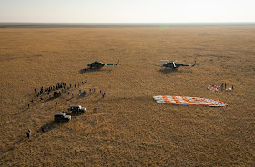
Expedition 40 Commander Steve Swanson of NASA and Flight Engineers Alexander Skvortsov and Oleg Artemyev of the Russian Federal Space Agency (Roscosmos) touched down southeast of the remote town of Dzhezkazgan in Kazakhstan at 10:23 p.m. EDT Wednesday, Sept. 10 (8:23 a.m., Sept. 11, in Dzhezkazgan).

During their time aboard the space station, the crew members participated in a variety of research focusing on Earth remote sensing, human behavior and performance and studies of bone and muscle physiology.

One of several key research focus areas during Expedition 40 was human health management for long duration space travel as NASA and Roscosmos prepare for two crew members to spend one year aboard the orbiting laboratory in 2015.


Image above: The Soyuz TMA-14M spacecraft carrying the Expedition 40 trio is seconds away from landing on time in Kazakhstan. Image Credit: NASA TV.

During their time on the station, the crew members orbited Earth more than 2,700 times, traveled more than 71.7 million miles and welcomed five cargo spacecraft. Two Russian ISS Progress cargo spacecraft docked to the station bringing tons of supplies in April and July. The fifth and final European Space Agency (ESA) Automated Transfer Vehicle also launched to the station in July with the spacecraft bearing the name of Belgian physicist Georges Lemaitre, who is considered the father of the big-bang theory.

SpaceX launched a Dragon cargo spacecraft to the station in April, the company's third of at least 12 planned commercial resupply missions. In July, Orbital Sciences’ Cygnus spacecraft completed its third of at least eight resupply missions scheduled through 2016 under NASA's Commercial Resupply Services contract.

 Expedition 40 Soyuz TMA-12M Landing. Image Credits: NASA /  Bill Ingalls.

During his time on the complex, Swanson ventured outside the confines of the space station for a spacewalk to replace a backup computer relay box that unexpectedly failed. Skvortsov and Artemyev conducted two spacewalks during Expedition 40, totaling 12 hours and 34 minutes.

The space station is more than a scientific research platform. It also serves as a test bed to demonstrate new technology. Even routine tasks, such as monitoring and operating the carbon dioxide removal system, provides valuable data for next-generation life support systems. Carbon dioxide removal from the pressurized compartments of the station proved to work differently in space than predicted by ground tests. The crew also saw the arrival of the Haptics-1 experiment, part of an effort to develop technology that would allow an astronaut in orbit to control a robot as it explores its target, such as an asteroid or Mars, during future human exploration missions.


Image above: A trio of International Space Station crew members returned to Earth and landed in Kazakhstan at 10:23 p.m. EDT on Sept. 10, 2014 (8:23 a.m., Sept. 11, in local time) after spending 167 days aboard the orbital laboratory. Seen left to right, Oleg Artemyev and Alexander Skvortsov of the Russian Federal Space Agency (Roscosmos) and NASA’s Steve Swanson were examined by medical personnel after being removed from their Russian Soyuz spacecraft. Image Credit: NASA TV.

Having completed his third space station mission, Swanson now has spent a total of 196 days in space. Skvortsov has accumulated 345 days in space on two flights, and Artemyev accrued 169 days in space on his first mission.

Expedition 41 now is operating aboard the station with Max Suraev of Roscosmos in command. Suraev and his crewmates, Flight Engineers Reid Wiseman of NASA and Alexander Gerst of ESA, will tend to the station as a three-person crew until the arrival in two weeks of three new crew members: Barry Wilmore of NASA and Alexander Samokutyaev and Elena Serova of Roscosmos. Wilmore, Samokutyaev and Serova are scheduled to launch from Kazakhstan Thursday, Sept. 25.

For more information on the International Space Station and its crews, visit: http://www.nasa.gov/station

For b-roll and other media resources, visit: http://www.nasa.gov/stationnews

Images (mentioned), Video, Text, Credits: NASA / Joshua Buck / Johnson Space Center / Dan Huot / NASA TV / ROSCOSMOS TV.

Greetings, Orbiter.ch

Station Trio Undocks Ending Expedition 40


ROSCOSMOS - Soyuz TMA-12M Mission patch.

September 10, 2014

Three Expedition 39/40 crew members are on their way home now having undocked at 7:01 p.m. EDT from the Poisk mini-research module. They will land in less than 3 ½ hours when their Soyuz TMA-12M spacecraft touches down in Kazakhstan.

Soyuz Commander Alexander Skvortsov of the Russian Federal Space Agency (Roscosmos), Expedition 40 Commander Steve Swanson and Flight Engineer Oleg Artemyev of Roscosmos closed the hatches to its Soyuz at 3:35 p.m. On Tuesday, Swanson handed over command of the International Space Station to cosmonaut Max Suraev during the traditional Change of Command Ceremony.

The homebound trio will orbit Earth twice before the Soyuz fires its deorbit engines at 9:30 p.m. sending the spacecraft on its way home. About 28 minutes later, the Soyuz spacecraft will separate into three sections with the descent module, sandwiched in between the orbital module and instrumentation/propulsion module, carrying the crew home.


Image above: The Expedition 40 trio waves goodbye to the Expedition 41 trio before closing the hatches to the Soyuz TMA-12M spacecraft. Image Credit: NASA TV.

The descent module will enter the atmosphere about 3 minutes later. The other two modules will burn up in the atmosphere. Two pilot parachutes will deploy first extracting the drogue chute to begin slowing the Soyuz’ descent. The main chute will then deploy in stages ultimately covering an area of 1,000 meters. Finally, less than a meter above the ground, rockets will fire to soften the landing as the Soyuz touches down in the steppe of Kazakhstan.

U.S. and Russian recovery personnel will be at the landing site southeast of the remote Kazakh town of Dzhezkazgan to extract the crew from the Soyuz. Medical personnel will then examine the crew at the landing site before they are helicoptered to Karaganda for a welcoming ceremony. Swanson will then be flown aboard a NASA jet back to the United States. Skvortsov and Artemyev will return to Star City, Russia.


Image above: The Expedition 40 trio poses for a portrait in their Russian Sokol launch and entry suits. Image Credit: Gagarin Cosmonaut Training Center.

Swanson, Skvortsov and Artemyev began their mission when they lifted off March 25 and docked to Poisk two days later. Their landing concludes 169 days in space during which Artemyev and Skvortsov conducted two spacewalks on June 19 and Aug. 18. Swanson was at the controls of the Canadarm2 and captured the Cygnus commercial cargo craft when it arrived July 16.

 Station Trio Boards Soyuz for Trip Back to Earth

Swanson flew to the station twice previously as a space shuttle mission specialist. In June 2007, he conducted two spacewalks at the space station after arriving aboard space shuttle Atlantis during STS-117. Swanson visited the station again in March 2009 during STS-119 aboard space shuttle Discovery and conducted a pair of spacewalks to install the S6 truss and outfit the orbital laboratory.

This was Skvortsov’s second tour of duty aboard the station. His first mission was in 2010 when he served as an Expedition 23 Flight Engineer and Expedition 24 Commander. He saw the arrival of space shuttles Discovery and Atlantis during the STS-131 and STS-132 missions.

Artemyev has completed his first space station mission.

Waiting back on Earth to replace the homebound trio are Soyuz Commander Alexander Samokutyaev of the Roscosmos and Flight Engineers Barry Wilmore of NASA and Elena Serova of Roscosmos. They represent the Expedition 41/42 trio and are scheduled to liftoff Sept. 25 aboard the Soyuz TMA-14M spacecraft.

 Expedition 40 Crew On the Way Home

Steve Swanson, Alexander Skvortsov and Oleg Artemyev undocked from the International Space Station's Poisk module at 7:01 p.m. EDT to begin their voyage home. The 4-minute, 40-second Soyuz TMA-12M deorbit burn completed at 9:35 p.m. EDT. The three Soyuz module sections separated at 9:58 p.m., atmospheric entry interface occurred at 10:01 p.m., parachutes have deployed and landing is targeted for 10:23 p.m. southeast of Dzhezkazgan in Kazakhstan.

For more information about the International Space Station (ISS), visit: http://www.nasa.gov/mission_pages/station/main/index.html

Images (mentioned), Videos, Text, Credits: NASA / NASA TV.

Greetings, Orbiter.ch

International Action Against Ozone Depleting Substances Yields Significant Gains


UNEP - United Nations Environmental Program logo.

September 10, 2014

Worldwide action to phase out ozone-depleting substances has resulted in remarkable success, according to a new assessment by 300 international scientists. The stratospheric ozone layer, a fragile shield of gas that protects Earth from harmful ultraviolet light, is on track to recovery over the next few decades.

The Assessment for Decision-Makers, a summary of the Scientific Assessment of Ozone Depletion 2014, provides new information to affirm that the 1987 international agreement known as the Montreal Protocol on Substances that Deplete the Ozone Layer has successfully resulted in global international policies to reduced levels of ozone-depleting substances.

Ozone Minimums, 1979 to 2013

Video above: Minimum concentration of ozone in the southern hemisphere for each year from 1979-2013 (there is no data from 1995). Each image is the day of the year with the lowest concentration of ozone. A graph of the lowest ozone amount for each year is shown. Image Credit: NASA's Goddard Space Flight Center/M. Radcliff.

The report is conducted by the World Meteorological Organization, or WMO, and the United Nations Environmental Program, or UNEP, and co-sponsored by NASA, National Oceanic and Atmospheric Administration, or NOAA, and the European Commission. Science teams from these organizations and other countries have been monitoring the ozone layer on the ground, by balloon and with a variety of satellite instruments dating back to NASA's Nimbus 4 satellite, launched in 1970.

The most current ozone hole satellite data comes from the Ozone Monitoring and Profiler Suite instrument on the NASA-NOAA Suomi National Polar-orbiting Partnership satellite, known as Suomi NPP, and the Ozone Monitoring Instrument and Microwave Limb Sounder on NASA's Aura satellite.


Image above: Satellites observed the largest ozone hole over Antarctica in 2006. Purple and blue represent areas of low ozone concentrations in the atmosphere; yellow and red are areas of higher concentrations. Image Credit: NASA.

"It is particularly gratifying to report that the ozone layer is on track for recovery to 1980 benchmark levels by mid-century," said Paul A. Newman, chief scientist for atmospheres at NASA's Goddard Space Flight Center in Greenbelt, Maryland, and a co-chair of the WMO/UNEP report. "Many of these early signs of ozone improvements are due to decades of work and contributions by NASA and NOAA instruments and scientists."

Ozone depleting substances are also powerful greenhouse gases. The Montreal Protocol provided a double benefit: stopping ozone depletion, and slowing the growth of greenhouse gases. “Substitutes for ozone depleting substances are ozone safe, but many are powerful greenhouse gases. These substitutes could offset the climate gains achieved by the Montreal Protocol in the future," Newman said.

The Assessment for Decision-Makers, a summary of the Scientific Assessment of Ozone Depletion 2014 is the first comprehensive update in four years. The full report will be available in early 2015.

Related Links:

- UNEP: Ozone Layer on Track to Recovery: Success Story Should Encourage Action on Climate: http://www.unep.org/newscentre/Default.aspx?DocumentID=2796&ArticleID=10978&l=en

- Assessment for Decision-Makers from UNEP/WMO (pdf): http://ozone.unep.org/Assessment_Panels/SAP/SAP2014_Assessment_for_Decision-Makers.pdf

- More information on the assessment from NOAA’s Earth System Research Laboratory: http://research.noaa.gov/News/NewsArchive/LatestNews/TabId/684/ArtMID/1768/ArticleID/10741/Ozone-layer-on-road-to-recovery.aspx

- NASA's Ozone Hole Watch website: http://ozonewatch.gsfc.nasa.gov/

- Gallery of HD ozone hole content from NASA Goddard's Scientific Visualization Studio: http://svs.gsfc.nasa.gov/Gallery/OzoneHole.html

Image (mentioned), Video (mentioned), Text, Credits: NASA's Goddard Space Flight Center / Audrey Haar.

Best regards, Orbiter.ch

Mars Rover Opportunity's Vista Includes Long Tracks


NASA - Mars Science Laboratory (MSL) patch.

September 10, 2014

Opportunity's Long Tracks on Crater Rim

From a ridgeline viewpoint, NASA's Mars Exploration Rover Opportunity recently recorded a scene looking back over its own tracks made from nearly half a mile (more than 700 meters) of southbound driving.

Opportunity's panoramic camera (Pancam) recorded the component images on Aug. 15, 2014, from an elevated portion of the west rim of Endeavour Crater. A brief video places the scene into context with the rover's entire driving route of more than 25 miles (40 kilometers) since the mission's 2004 landing in the Meridiani Planum region of Mars. The video is online at:

http://www.jpl.nasa.gov/video/?id=1325

The Pancam image in approximate true color is available at:

http://www.jpl.nasa.gov/spaceimages/details.php?id=PIA18604

The Opportunity mission has been investigating outcrops on the western rim of Endeavour Crater for three years. The crater spans 14 miles (22 kilometers) in diameter. During Opportunity's first decade on Mars and the 2004-to-2010 career of its twin, Spirit, NASA's Mars Exploration Rover Project yielded a range of findings proving wet environmental conditions on ancient Mars -- some very acidic, others milder and more conducive to supporting life.


Image above: This scene from the Pancam on NASA's Mars Exploration Rover Opportunity looks back toward part of the west rim of Endeavour Crater that the rover drove along, heading southward, during the summer of 2014. It combines exposures taken on Aug. 15, 2014, and is presented in approximate true color. Image Credit: NASA/JPL-Caltech/Cornell Univ./Arizona State Univ.

NASA's Jet Propulsion Laboratory, Pasadena, California, manages the Mars Exploration Rover Project for NASA's Science Mission Directorate in Washington. The California Institute of Technology in Pasadena manages JPL for NASA.

For more information about Spirit and Opportunity, visit:

http://www.nasa.gov/rovers

http://marsrovers.jpl.nasa.gov

You can follow the project on Twitter at:

http://twitter.com/MarsRovers

Image (mentioned), Video, Text, Credits: NASA / JPL / Guy Webster.

Greetings, Orbiter.ch

A Significant Flare Surges Off the Sun


NASA - Solar Dynamics Observatory (SDO) patch.

September 10, 2014


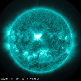
Image above: An X1.6 class solar flare flashes in the middle of the sun on Sept. 10, 2014. This image was captured by NASA's Solar Dynamics Observatory and shows light in the 131 Angstrom wavelength, which is typically colorized in teal. Image Credit: NASA/SDO.

The sun emitted a significant solar flare, peaking at 1:48 p.m. EDT on Sept. 10, 2014. NASA's Solar Dynamics Observatory captured images of the event. Solar flares are powerful bursts of radiation. Harmful radiation from a flare cannot pass through Earth's atmosphere to physically affect humans on the ground.  However -- when intense enough -- they can disturb the atmosphere in the layer where GPS and communications signals travel.

To see how this event may affect Earth, please visit NOAA's Space Weather Prediction Center at http://spaceweather.gov, the U.S. government's official source for space weather forecasts, alerts, watches and warnings.

This flare is classified as an X1.6 class flare. "X-class" denotes the most intense flares, while the number provides more information about its strength. An X2 is twice as intense as an X1, an X3 is three times as intense, etc.

Updates will be provided as needed.

What is a solar flare?

For answers to this and other space weather questions, please visit the Spaceweather Frequently Asked Questions page: http://www.nasa.gov/mission_pages/sunearth/spaceweather/index.html

Related Link:

View Past Solar Activity: http://www.nasa.gov/mission_pages/sunearth/multimedia/Solar-Events.html

For more information about Solar Dynamics Observatory (SDO), visit: http://sdo.gsfc.nasa.gov/

Image (mentioned), Text, Credits: NASA's Goddard Space Flight Center/Karen C. Fox.

Greetings. Orbiter.ch

Unprecedented X-ray View of Supernova Remains


ESA - XMM-Newton Mission patch.

Sept. 10, 2014

Unprecedented X-ray View of Supernova Remains

The destructive results of a powerful supernova explosion reveal themselves in a delicate tapestry of X-ray light, as seen in this image from NASA’s Chandra X-Ray Observatory and the European Space Agency's XMM-Newton.

The image shows the remains of a supernova that would have been witnessed on Earth about 3,700 years ago. The remnant is called Puppis A, and is around 7,000 light years away and about 10 light years across. This image provides the most complete and detailed X-ray view of Puppis A ever obtained, made by combining a mosaic of different Chandra and XMM-Newton observations. Low-energy X-rays are shown in red, medium-energy X-rays are in green and high energy X-rays are colored blue.

These observations act as a probe of the gas surrounding Puppis A, known as the interstellar medium. The complex appearance of the remnant shows that Puppis A is expanding into an interstellar medium that probably has a knotty structure.

Supernova explosions forge the heavy elements that can provide the raw material from which future generations of stars and planets will form. Studying how supernova remnants expand into the galaxy and interact with other material provides critical clues into our own origins.

A paper describing these results was published in the July 2013 issue of Astronomy and Astrophysics and is available online. The first author is Gloria Dubner from the Instituto de Astronomía y Física del Espacio in Buenos Aires in Argentina.

For more information about XMM-Newton Mission, visit: http://sci.esa.int/xmm-newton/

Chandra on Flickr: http://www.flickr.com/photos/nasamarshall/sets/72157606205297786/

Image, Text, Credits: NASA/CXC/IAFE/G.Dubner et al & ESA/XMM-Newton.

Cheers, Orbiter.ch

This Star Cluster Is Not What It Seems


ESO - European Southern Observatory logo.

10 September 2014

VLT observations of Messier 54 show the lithium problem also applies outside our galaxy

The globular star cluster Messier 54

This new image from the VLT Survey Telescope at ESO’s Paranal Observatory in northern Chile shows a vast collection of stars, the globular cluster Messier 54. This cluster looks very similar to many others but it has a secret. Messier 54 doesn’t belong to the Milky Way, but is part of a small satellite galaxy, the Sagittarius Dwarf Galaxy. This unusual parentage has now allowed astronomers to use the Very Large Telescope (VLT) to test whether there are also unexpectedly low levels of the element lithium in stars outside the Milky Way.

The globular star cluster Messier 54 in the constellation of Sagittarius

The Milky Way galaxy is orbited by more than 150 globular star clusters, which are balls of hundreds of thousands of old stars dating back to the formation of the galaxy. One of these, along with several others in the constellation of Sagittarius (The Archer), was found in the late eighteenth century by the French comet hunter Charles Messier and given the designation Messier 54.

Wide-field view of the sky around the globular star cluster Messier 54

For more than two hundred years after its discovery Messier 54 was thought to be similar to the other Milky Way globulars. But in 1994 it was discovered that it was actually associated with a separate galaxy — the Sagittarius Dwarf Galaxy. It was found to be at a distance of around 90 000 light-years — more than three times as far from Earth as the galactic centre.

Astronomers have now observed Messier 54 using the VLT as a test case to try to solve one of the mysteries of modern astronomy — the lithium problem.

Zooming in on the globular star cluster Messier 54

Most of the light chemical element lithium now present in the Universe was produced during the Big Bang, along with hydrogen and helium, but in much smaller quantities. Astronomers can calculate quite accurately how much lithium they expect to find in the early Universe, and from this work out how much they should see in old stars. But the numbers don’t match — there is about three times less lithium in stars than expected. This mystery remains, despite several decades of work [1].

Up to now it has only been possible to measure lithium in stars in the Milky Way. But now a team of astronomers led by Alessio Mucciarelli (University of Bologna, Italy) has used the VLT to measure how much lithium there is in a selection of stars in Messier 54. They find that the levels are close to those in the Milky Way. So, whatever it is that got rid of the lithium seems not to be specific to the Milky Way.

Close-up view of the globular star cluster Messier 54

This new image of the cluster was created from data taken with the VLT Survey Telescope (VST) at the Paranal Observatory. As well as showing the cluster itself it reveals the extraordinarily dense forest of much closer Milky Way stars that lie in the foreground.

Notes:

[1] There are several possible proposed solutions to the riddle. The first is that the calculations of the amounts of lithium produced in the Big Bang are wrong — but very recent tests suggest that this is not the case. The second is that the lithium was somehow destroyed in the earliest stars, before the formation of the Milky Way. The third is that some process in the stars has gradually destroyed lithium during their lives.

More information:

This research was presented in a paper, “The cosmological Lithium problem outside the Galaxy: the Sagittarius globular cluster M54”, by A. Mucciarelli et al., to appear in Monthly Notices of the Royal Astronomical Society (Oxford University Press).

The team is composed of: A. Mucciarelli (University of Bologna, Italy), M. Salaris (Liverpool John Moores University, Liverpool, UK), P. Bonifacio (Observatoire de Paris, France), L. Monaco (ESO, Santiago, Chile) and S. Villanova (Universidad de Concepcion, Concepcion, Chile).

ESO is the foremost intergovernmental astronomy organisation in Europe and the world’s most productive ground-based astronomical observatory by far. It is supported by 15 countries: Austria, Belgium, Brazil, the Czech Republic, Denmark, France, Finland, Germany, Italy, the Netherlands, Portugal, Spain, Sweden, Switzerland and the United Kingdom. ESO carries out an ambitious programme focused on the design, construction and operation of powerful ground-based observing facilities enabling astronomers to make important scientific discoveries. ESO also plays a leading role in promoting and organising cooperation in astronomical research. ESO operates three unique world-class observing sites in Chile: La Silla, Paranal and Chajnantor. At Paranal, ESO operates the Very Large Telescope, the world’s most advanced visible-light astronomical observatory and two survey telescopes. VISTA works in the infrared and is the world’s largest survey telescope and the VLT Survey Telescope is the largest telescope designed to exclusively survey the skies in visible light. ESO is the European partner of a revolutionary astronomical telescope ALMA, the largest astronomical project in existence. ESO is currently planning the 39-metre European Extremely Large optical/near-infrared Telescope, the E-ELT, which will become “the world’s biggest eye on the sky”.

Links:

Research paper: http://www.eso.org/public/archives/releases/sciencepapers/eso1428/eso1428a.pdf

Photos of the VST: http://www.eso.org/public/images/archive/category/surveytelescopes/

Images, Text, Credits: ESO/IAU and Sky & Telescope/Digitized Sky Survey 2/Videos: ESO/N. Risinger (skysurvey.org). Music: John Dyson.

Greetings, Orbiter.ch

Bardarbunga belches


ESA - EPS METOP Mission logo.

10 September 2014

Satellites are showing clouds of sulphur dioxide from Iceland’s restive Bardarbunga volcano.

ESA’s Volcanic Ash Strategic Initiative Team (VAST) and Support to Aviation Control Service (SACS) are monitoring the situation closely, and have detected sulphur dioxide emissions since early September. A small cloud of sulphur dioxide has been drifting toward Europe since late last night.

The Bardarbunga volcano has shown heightening activity since mid-August, causing thousands of local earthquakes, spewing lava and threatening air travel. The aviation alert level is high, fluctuating between orange and red as the potential of eruption is increased.

Bardarbunga plume

“The current volcanic activity is typically effusive and no ash has been detected so far with satellite measurements,” said Nicolas Theys from the Belgian Institute for Space Aeronomy.

“SACS, VAST and ESA partners will continue monitoring volcanic emissions over Bardarbunga and provide added-value services, in case the eruption becomes explosive, causing ash-producing activity with possible consequences for European air space.”

The presence of ash in the atmosphere can endanger jet engines, so timely information about ash, sulphur dioxide clouds and their dispersion are crucial to alert civil aviation authorities.

Bardarbunga sulphur dioxide spread

Earth-observing satellites can provide this information, especially for toxic gases like sulphur dioxide, which cannot be seen with the naked eye. With frequent and worldwide measurements of ash plumes and sulphur dioxide emissions, satellites help to improve aviation safety.

SACS and VAST uses multiple satellites – including Europe’s MetOp and Meteosat missions – to provide early warning information about volcanic eruptions.

When an eruption occurs, an alert is sent to interested users, most notably to Volcanic Ash Advisory Centres and airlines, and public maps are generated showing the extent and intensity of the volcanic plumes.

Related links:

Support to Aviation Control Service: http://sacs.aeronomie.be/index.php

Volcanic Ash Strategic Initiative Team (VAST): http://vast.nilu.no/

London Volcanic Ash Advisory Centre (VAAC): http://www.metoffice.gov.uk/aviation/vaac/

Icelandic Met Office: http://en.vedur.is/

O3MSAF: http://o3msaf.fmi.fi/

BIRA-IASB: http://www.aeronomie.be/

DLR: http://www.dlr.de/dlr/en/desktopdefault.aspx/tabid-10002/

EUMETSAT: http://www.eumetsat.int/

NILU–Support to Aviation for Volcanic Ash Avoidance: http://savaa.nilu.no/

Related missions:

MetOp: http://www.esa.int/Our_Activities/Observing_the_Earth/MetOp_overview

MSG: http://www.esa.int/msg

Animations, Text, Credits: ESA / NILU / BIRA / IASB.

Greetings, Orbiter.ch
mardi 9 septembre 2014

Science Continues on Orbital Lab While Trio Prepares for Departure


ISS - Expedition 40 Mission patch.

September 9, 2014

One set of Expedition 40 crew members is working advanced microgravity science while another set is wrapping up its stay in space.

NASA astronaut Reid Wiseman started his morning on a pair of fluid physics experiments. He first photographed samples of colloids, or microscopic particles suspended in liquids, for a version of the Binary Colloid Alloy Test experiment subtitled Low Gravity Phase Kinetics-Critical Point (BCAT-KP-1). Results may contribute to more advanced consumer products with unique properties and longer shelf lives.


Image above: NASA astronaut Steve Swanson (right foreground) handed over command of the International Space Station to Roscosmos cosmonaut Max Suraev (left foreground) Tuesday afternoon. Image Credit: NASA TV.

Wiseman then set up the bowling ball-sized satellites known as SPHERES (Synchronized Position Hold Engage Reorient Experimental Satellites) inside the Kibo laboratory to study how liquids behave inside containers in microgravity. The experiment, named SPHERES-Slosh, maneuvers the tiny satellites similar to an actual spacecraft with an externally mounted tank and observes the interaction between the sloshing fluid and the tank/vehicle dynamics.

Read more about SPHERES-Slosh: http://www.nasa.gov/mission_pages/station/research/experiments/980.html

German astronaut Alexander Gerst from the European Space Agency spent his afternoon installing a microscope for the Cell Mechanosensing-2 experiment. The Japanese experiment, which takes place in the Kibo lab’s Kobairo rack, seeks to identify gravity sensors in cells that may change the expression of key proteins and genes and allowing muscles to atrophy in microgravity.

Read more about the Cell Mechanosensing-2 experiment: http://www.nasa.gov/mission_pages/station/research/experiments/1207.html

Flight Engineer Max Suraev assisted his fellow cosmonauts Alexander Skvortsov and Oleg Artemyev as they donned Lower Body Negative Pressure suits during their exercise sessions. The anti-gravity suits alleviate the effects of returning to gravity by preventing blood from pooling in a crew member’s lower extremities during descent.

Suraev then moved some Russian science hardware before moving on to a radiation exposure experiment. Wiseman handed over dosimeters from the U.S. segment to Suraev so he could collect data for the Matryoshka study, which looks into how the station’s radiation environment affects a mannequin composed of materials that simulate human tissue.

Read more about Matryoshka: http://www.nasa.gov/mission_pages/station/research/experiments/643.html

Skvortsov and Artemyev had time set aside for light science and maintenance work while they worked toward their departure. Artemyev sampled the air inside the Zvezda service module for ammonia and monitored its sanitary and epidemiological status. Skvortsov worked with Suraev collecting and preparing Matryoshka detectors for return to Earth.

International Space Station (ISS). Image Credit: NASA

Commander Steve Swanson collected a urine sample and stored it in a science freezer first thing in the morning. He then stowed a medical kit and cleaned port-side crew quarters before working inside the Combustion Integrated Rack for hardware maintenance.


Expedition 40 Hands Over the Space Station to Expedition 41

Swanson handed over command of the International Space Station to Suraev Tuesday at 5:15 p.m. EDT in a traditional Change of Command Ceremony. He and his Expedition 39/40 crewmates, Skvortsov and Artemyev, are due to undock from the Poisk mini-research module Wednesday at 7:01 p.m. officially ending their mission. They will land in Kazakhstan about 3-1/2 hours later.

Watch NASA Television for live undocking activities on Wednesday. Coverage begins at 3:15 p.m. with crew farewells and hatch closure scheduled for 3:35 p.m. NASA TV will return at 6:45 p.m. for undocking coverage. Finally, landing coverage begins at 9:15 p.m. with the deorbit burn scheduled at 9:30 p.m. and landing at 10:23 p.m.

Watch NASA Television: http://www.nasa.gov/nasatv

Crew Landing TV Schedule: http://www.nasa.gov/press/2014/september/nasa-television-to-broadcast-sept-10-return-of-space-station-crew/

Images (mentioned), Video, Text, Credit: NASA / NASA TV.

Cheers, Orbiter.ch

NASA Identifying Candidate Asteroids for Redirect Mission


NASA logo.

September 9, 2014

NASA is on the hunt to add potential candidate target asteroids for the agency's Asteroid Redirect Mission (ARM). The robotic mission will identify, capture and redirect a near-Earth asteroid to a stable orbit around the moon. In the 2020s, astronauts will explore the asteroid and return to Earth with samples. This will test and advance new technologies and spaceflight experience needed to take humans to Mars in the 2030s.

NASA has two options for robotic asteroid capture. One concept would capture a small asteroid in its "native orbit" – the natural orbit in which it is found. The other would retrieve a boulder from a larger asteroid. NASA will decide between the capture options in December and hold a Mission Concept Review in early 2015, which will further refine the design of the mission.

Astronaut explore the asteroid and return to Earth with samples. Image Credit: NASA

A lean, agile team of NASA engineers are testing the two concepts, capitalizing on technology and engineering work already underway at NASA. Four industry teams selected through NASA’s recent Broad Agency Announcement also are developing concepts to either enhance this work or provide alternative ideas.

NASA’s plans to announce the target asteroid for the mission approximately a year before launching the robotic spacecraft, scheduled for no earlier than 2019. To date NASA has identified three valid candidates for the small asteroid concept and three for the boulder concept. The agency expects to identify one or two additional candidates each year that could become valid targets for the mission.

Before an asteroid can make the valid candidate list, NASA’s ARM target identification criteria must be met. Scientists must determine the rotation, shape, precise orbit, spectral class, and most importantly, size of the asteroid itself. With the asteroid millions of miles away from Earth, defining these factors requires a series of observations and analysis.


Images above: On the left, a notional concept image of ARM robotic capture option A, which would envelop an entire free-flying asteroid. On the right, a notional concept image of ARM robotic capture option B, which would retrieve a bolder from a larger asteroid. Image Credit: NASA.

Telescopes on Earth and in space contribute to the observation, tracking and characterization of an asteroid. The process begins by detecting Near Earth Objects (NEOs) and starting to track their orbits. Ground observatories first scan an area in the sky to detect an object moving across the background of stationary stars and report its position in relation to them. The International Astronomical Union Minor Planet Center collects the resulting data and determines if the object has already been identified. If classified as a new object, scientists will be able to have a rough orbit and estimate of the size of the object within a day or two of the initial discovery.

Detecting an asteroid isn’t enough to conclude it could be a good candidate for NASA’s asteroid mission. Scientists need to further understand an asteroid’s shape, size, spin rate, and even surface features when picking a candidate. The best way to precisely measure these characteristics is with interplanetary radar, but only if the object is close enough to Earth to be observed this way. When the asteroid is not within the range of radar, the NASA's Spitzer Space Telescope can contribute to the data collection using infrared imaging if the object can be seen by it.

Infrared light is a better indicator of an object’s true size because by measuring its infrared glow the amount of solar heating the entire object re-radiates can be determined. Combining the data collected by Spitzer and ground observatories allows an asteroid’s density and mass to be more precisely estimated. Spitzer’s infrared imaging has enabled NASA to determine the size of two ARM candidates thus far.


Image above: This image of asteroid 2011 MD was taken by NASA's Spitzer Space Telescope in Feb. 2014, over a period of 20 hours. Image Credit: NASA/JPL-Caltech/Northern Arizona University/SAO.

The three valid candidates so far for the small asteroid concept are 2009 BD, 2011 MD and 2013 EC20. The size of 2009 BD is estimated to be roughly 4 meters (13 feet) in size, while 2011 MD is estimated to be approximately 6 meters (20 feet). These sizes are inferred by data provided by the Spitzer observatory. 2013 EC20 is about 2 meters (7 feet) in size, as determined by radar imaging.

Most known large asteroids are too big to be fully captured and have orbits too distant for the ARM spacecraft to redirect them into orbit around the moon. Some are so distant when discovered that their size and makeup are difficult for even our most powerful telescopes to discern. Still, others could be potential candidates but go from newly discovered to out of our telescope range so quickly that there is not enough time to observe them adequately.

There are currently three validated asteroid candidates for the boulder concept, known as Itokawa, Bennu and 2008 EV5. Itokawa was well characterized by close and direct observation on the Japanese Hayabusa mission and is known to contain boulders an ideal size of roughly 3 meters (10 feet). Both 2008 EV5 and Bennu have been imaged via radar, collecting data from which it can be inferred they have boulders of the appropriate size. In addition, NASA’s OSIRIS-REx mission to launch in 2016 will study Bennu, and conduct detailed mapping of the surface of the asteroid in addition to taking samples and returning them to Earth for further study.


Animations above: On the left, a compilation of radar images of asteroid Bennu (formerly 1999 RQ36). On the right, a shape model based on available characteristics.  

Any asteroid ultimately chosen for the mission will contain remnants of material from the solar system's formation. In the 2020s, astronauts will visit the asteroid for a number of activities, including returning to Earth with substantial selected samples. The results could open new scientific learning about the formation of our solar system and the beginning of life on Earth, inform us about what resources asteroids may contain for use in future exploration, and foster partnerships with industry for future endeavors in space.

Animation: Asteroid Redirect Mission

ARM will help NASA test and advance the technologies necessary for future human missions to and from Mars, including Solar Electric Propulsion, human spaceflight aboard the Orion spacecraft and the Space Launch System (SLS) rocket, and complex mission operations in deep space orbits. To learn more about ARM’s impact on the manned mission to Mars, visit How Will NASA's Asteroid Redirect Mission Help Humans Reach Mars?

Related links:

Broad Agency Announcement: http://www.nasa.gov/content/nasa-selects-studies-for-the-asteroid-redirect-mission/

Near Earth Objects (NEOs): http://neo.jpl.nasa.gov/

The International Astronomical Union Minor Planet Center: http://www.minorplanetcenter.net/iau/mpc.html

NASA's Spitzer Space Telescope: http://www.nasa.gov/mission_pages/spitzer/main/index.html#.U-khYiTQQlE

OSIRIS-REx mission: http://www.nasa.gov/mission_pages/osiris-rex/#.U-khmyTQQlE

Orion spacecraft: http://www.nasa.gov/orion

Space Launch System (SLS) rocket: http://www.nasa.gov/sls

How Will NASA's Asteroid Redirect Mission Help Humans Reach Mars?: http://www.nasa.gov/content/how-will-nasas-asteroid-redirect-mission-help-humans-reach-mars/

Images (mentioned), Animations, Video, Text, Credit: NASA.

Best regards, Orbiter.ch