lundi 23 mai 2011

Satellites monitor Icelandic ash plume


ESA - EPS METOP Satellite logo / ESA - Meteosat Second Generation Satellite logo.

23 May 2011

As Iceland's Grímsvötn volcano spews ash high into the atmosphere, satellite observations are providing essential information to advisory centres assessing the possible hazards to aviation.

The Grímsvötn volcano in southeast Iceland, which had been dormant since 2004, started erupting in the evening of 21 May. As a consequence, the country's airspace has been closed.
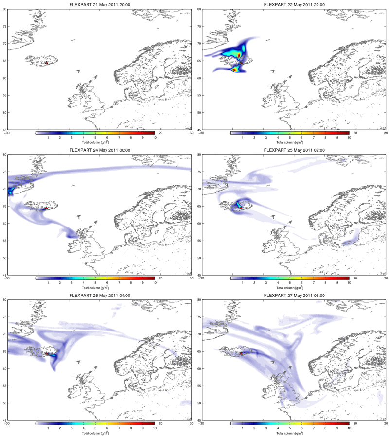
Predicted path of volcanic ash

Memories are still fresh of the chaos caused by the Eyjafjallajoekull eruption just over a year ago. European air traffic suffered major disruption, with hundreds of flights grounded owing to safety concerns about the ash cloud.

Although the Grímsvötn eruption is larger, it is unlikely to cause the same degree of disruption because the ash plume is being injected much higher into the atmosphere.

Ground-based radar measurements in Iceland indicate that the ash reached heights of 12–17 km and is initially moving towards northern Scandinavia.
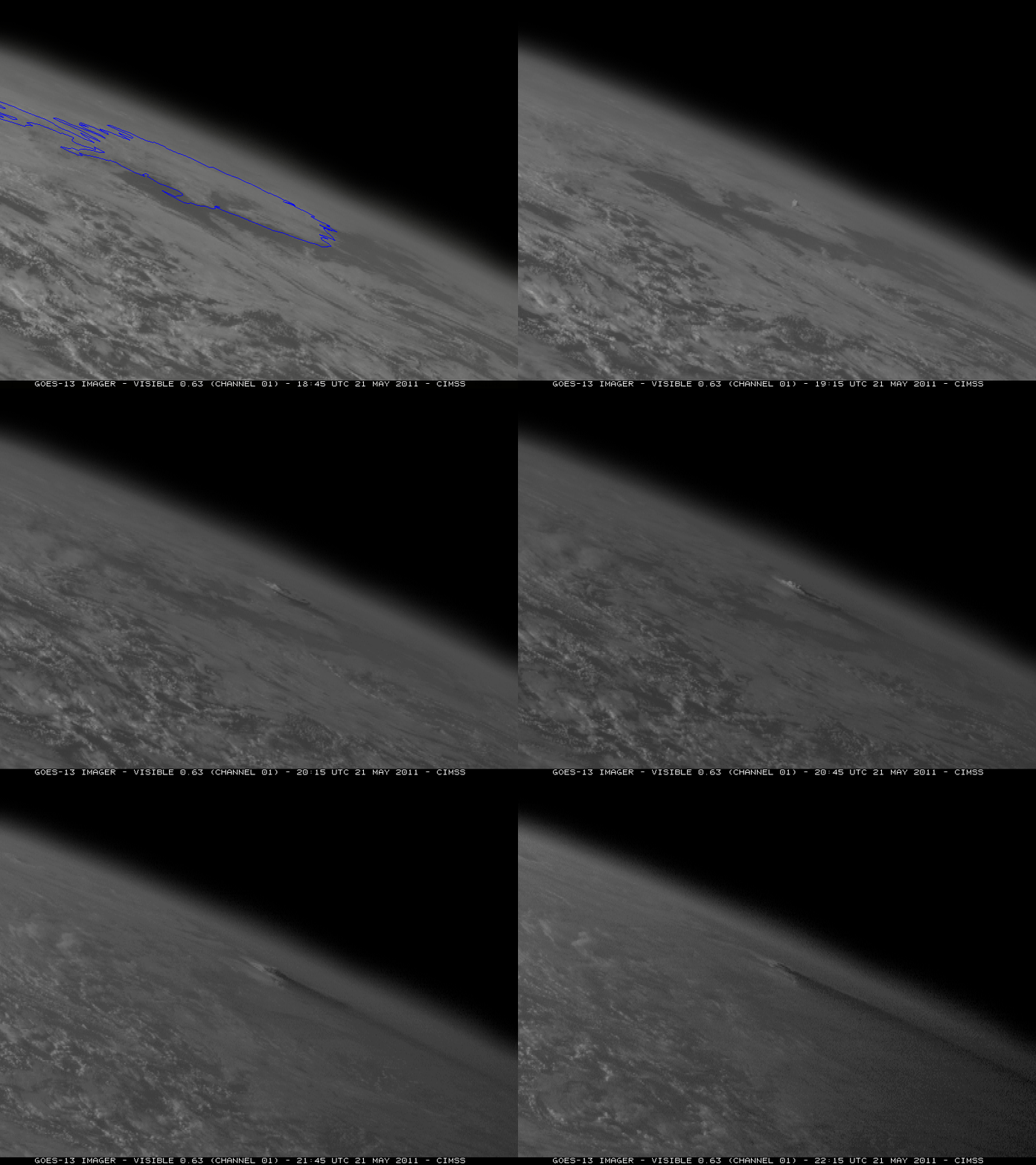
Grímsvötn volcanic eruption

As an expert in the remote sensing of volcanic plumes and the leader of ESA's Support to Aviation for Volcanic Ash Avoidance project, Fred Prata from the Norwegian Institute for Air Research states, "It was initially an ash-rich eruption that was also very wet. A large amount of ash has fallen out, mostly in the proximity of Iceland.

"The volcano has also emitted a lot of sulphur dioxide that has been spreading north and northeast. Because this has been a high eruption there is less likelihood that it will affect continental and European aviation.

"Things could change if there is more volcanic activity – so it is important to monitor the ongoing eruption."

Following the Eyjafjallajoekull eruption, new aviation security guidelines have been agreed. For example, no-fly zones are designated where ash concentrations are higher than 4 mg/m3.

The London Volcanic Ash Advisory Centre (VAAC) responsible for Icelandic eruptions collects all available information and issues advice to aviation companies.

Ash plume

Satellite measurements offer an excellent means to follow the spread, extension, concentration and movement of volcanic plumes. To this end, ESA has developed dedicated services to provide fast alerts on volcanic eruptions to support VAACs within the Support to Aviation Control Service project.

The Infrared Atmospheric Sounding Interferometer carried on Europe's polar-orbiting MetOp weather satellite was one of the first instruments to provide data for warnings concerning the current eruption.

Geostationary satellites can also follow the plume's progression, offering new data every 15 minutes. These data come from the Spinning Enhanced Visible and Infrared Imager on Europe's Meteosat Second Generation satellites and from the US Geostationary Operational Environmental Satellites.

Dispersion models that use key information such as the height of the plume at the eruption site can used to help forecast the ash cloud's path.

Sulphur dioxide emissions from Grímsvötn

The animation here shows that the volcanic plume split into a sulphur dioxide component that is now being carried northeast over the Arctic Ocean. The other component, which consists mainly of ash, is being transported towards the southeast, but is currently not posing a threat to aviation over Europe.

Only the efficient combination of different measurements acquired from satellites, aircraft and in situ, along with models that are being developed in preparation for services for the Global Monitoring for Environment and Security initiative will ensure safe aviation over Europe during volcanic eruptions.

Related links:

NILU–Support to Aviation for Volcanic Ash Avoidance: http://savaa.nilu.no/

Belgian Institute for Space Aeronomy–Support to Aviation Control Service: http://sacs.aeronomie.be/

Icelandic Met Office: http://en.vedur.is/

Cooperative Institute for Meteorological Satellite Studies–blog: http://cimss.ssec.wisc.edu/goes/blog/

London Volcanic Ash Advisory Centre: http://www.metoffice.gov.uk/aviation/vaac/

Eumetsat: http://www.eumetsat.int/Home/index.htm

GMES: http://www.esa.int/esaLP/LPgmes.html

Images, Animations, Text, Credits: ESA / NILU / Cooperative Institute for Meteorological Satellite Studies / BIRA / IASB–Belgian Institute for Space Aeronomy.

Best regards, Orbiter.ch

Galileo: Europe prepares for October launch


ESA - GALILEO Constellation Satellites logo.

23 May 2011

ESA - The European Space Agency, Arianespace and the European Commission announced today that the launch of the first two satellites of Europe's global navigation satellite system is planned to take place on 20 October.

This will be the first of a series of Galileo satellite launches by Arianespace from Europe's Spaceport in French Guiana.

The announcement follows a detailed review held on 12 May, under the chairmanship of the Director General of the European Space Agency (ESA) and with the participation of Arianespace and industrial prime contractors, which concluded that the space and ground elements will be ready for a launch in October.

First two Galileo IOV satellites

The two Galileo satellites will be deployed using a Soyuz launcher. The October launch will mark the inaugural Soyuz flight from its new launch facilities in French Guiana, built in the framework of a programme of the European Space Agency.

Jean-Jacques Dordain, Director General of ESA, pointed out the significance of this launch: "The October launch will be a perfect example of European and international cooperation. On one side we will have the first operational Galileo satellites in orbit, resulting from the cooperation between the European Union and ESA.

"On the other side, this is the first launch of Soyuz from French Guiana, a programme made possible through the cooperation between ESA and Russia."

Soyuz launching from French Guiana

"Arianespace is both proud and honoured to be contributing to this innovative project, reflecting the innovative technologies that are constantly being developed in Europe for the benefit of all citizens," said Jean-Yves Le Gall, Chairman and CEO of Arianespace.

"I would like to thank the European Commission and ESA for choosing our launch services, further recognition of our market leadership.

"With this launch, we will also be opening a new chapter in our own history, as we start Soyuz operations from the Guiana Space Centre. More than ever, we will be able to deliver the full range of launch services expected by our customers from around the world."

Background

The Galileo programme is Europe's initiative for a state-of-the-art global satellite navigation system, providing a highly accurate, guaranteed global positioning service under civil control.

Galileo satnav system
  
The definition, development and In-Orbit Validation phases were carried out by ESA and co-funded by ESA and the European Community.

The Full Operational Capability phase of the Galileo programme is managed and fully funded by the European Commission. The Commission and ESA have signed a delegation agreement by which ESA acts as design and procurement agent on behalf of the Commission.

ROSCOSMOS - Two Soyuz Rockets Shipped to CSG from TsSKB-Progress

Two Soyuz-ST-B rockets have been shipped to Guiana Space Center from TsSKB-Progress.
The rockets will be delivered first to the port of St. Petersbourg. Here, the Soyuzes will be loaded on the ship to be transported to French Guiana in June.


The shipment under Soyuz at the Guiana Space Center program implies no less than 50 Soyuz launches from Guiana within 15 years. The maiden launch is slated for this fall.

About Soyuz at the Guiana Space Center

The European Space Agency (ESA) set up the program “Soyuz at the Guiana Space Center (CSG)” to bolster collaboration with Russia on launch vehicles. The program is organized as follows:
• ESA is contracting authority and program manager and provides the Soyuz Launch Complex facilities to Arianespace.
• Russian Federal Space Agency (Roscosmos) bears overall responsibility for the program on the Russian side, and coordinates the activities of the Russian industry involved in the program.
• French space agency CNES is project prime contractor and system architect for the Soyuz launch system at CSG.
• Arianespace is responsible for the supply of Russian systems to CSG, coordination and support of the Russian activities for the development phase. Arianespace will be the Soyuz-ST launch operator at CSG for the operational phase.

Related links:

Galileo website (European Commission): http://www.ec.europa.eu/enterprise/policies/satnav

European GNSS Agency: http://www.gsa.europa.eu/

Arianespace: http://www.arianespace.com/

Images, Text, Credit: ESA / J. Huart / Roscosmos PAO.

Cheers, Orbiter.ch

dimanche 22 mai 2011

Fincke, Feustel Progressing on Second Spacewalk


NASA - STS-134 Mission patch.

Sun, 22 May 2011

Spacewalker Mike Fincke installed two radiator grapple bar stowage beams on the S1 segment of the station’s truss. The beams will be used to store handles that would be necessary if a radiator ever needed to be replaced.


Image above: Mission Specialists Drew Feustel (top) and Mike Fincke conduct the second spacewalk of the STS-134 mission. Photo credit: NASA TV.

Meanwhile, astronaut Drew Feustel conducted work on the Special Purpose Dexterous Manipulator, or Dextre. Inside the space station, astronauts Greg Johnson and Cady Coleman manipulated the station’s robotic arm to deliver Dextre to Feustel. He then installed a cover on one of the robot’s cameras and lubricated the snares that allow the robot to grab equipment.

STS-134 Daily Mission Recap - Flight Day 6

Both spacewalkers now are headed back to the P3 solar alpha rotary joint to apply another layer of lubricant. Flight controllers on the ground in Houston have rotated the solar alpha rotary joint 200 degrees to spread the first layer of grease. If Feustel and Fincke have time, they also will replace covers 16, 13 and 9 before making their way back to the Quest airlock.

Astronauts Drew Feustel and Mike Fincke completed an eight hour, seven minute spacewalk at 10:12 a.m. EDT, the 6th longest spacewalk in history. They completed all planned tasks, including refilling one of the station’s cooling loops with ammonia and lubricating one of the station’s massive solar alpha rotary joints.

STS-134 EVA-2 (Mike Fincke and Andrew Feustel)

This was the second of the four STS-134 spacewalks, for a mission total of 14 hours 26 minutes. It was the 246th spacewalk conducted by U.S. astronauts, the 116th from space station airlocks, and the 157th in support of space station assembly and maintenance, totaling 988 hours, 19 min. It was Feustel's fifth spacewalk for a total time of 35 hours and 24 minutes; he is 30th on the all-time list. It was Fincke's seventh spacewalk for a total time of 34 hours and 19 minutes; he is 32nd on the all-time list.

Exploring the Wonders of the Universe


Image above: The newly-installed Alpha Magnetic Spectrometer-2 is visible at center of the International Space Station's starboard truss. The Alpha Magnetic Spectrometer, or AMS, is the largest scientific collaboration to use the orbital laboratory. This investigation is sponsored by the U.S. Department of Energy and made possible by funding from 16 nations. Led by Nobel Laureate Samuel Ting, more than 600 physicists from around the globe will be able to participate in the data generated from this particle physics detector. The mission of the AMS is, in part, to seek answers to the mysteries of antimatter, dark matter and cosmic ray propagation in the universe.

The crew members for space shuttle Endeavour's STS-134 mission are Commander Mark Kelly, Pilot Gregory H. Johnson and Mission Specialists Michael Fincke, Greg Chamitoff, Andrew Feustel and European Space Agency astronaut Roberto Vittori.

During the 16-day mission, Endeavour and its crew will deliver the Alpha Magnetic Spectrometer (AMS) and spare parts including two S-band communications antennas, a high-pressure gas tank and additional spare parts for Dextre.

NASA's web coverage of STS-134 includes mission information, a press kit, interactive features, news conference images, graphics and videos. Mission coverage, including the latest NASA Television schedule, is available on the main space shuttle website at: http://www.nasa.gov/shuttle

NASA is providing continuous television and Internet coverage of the mission. NASA TV features live mission events, daily status news conferences and 24-hour commentary. For NASA TV streaming video, downlink and schedule information, visit: http://www.nasa.gov/ntv

Images, Videos, Text, Credit: NASA / NASA TV.

Greetings, Orbiter.ch

vendredi 20 mai 2011

First Spacewalk Complete; Focused Inspection to Proceed


NASA - STS-134 Mission patch.

Sat, 21 May 2011

Endeavour astronauts completed a 6-hour, 19-minute spacewalk at the International Space Station Friday, retrieving materials experiments and installing another, and installing an antenna.

STS-134 Daily Mission Recap - Flight Day 5
 
Mission Specialists Andrew Feustel and Greg Chamitoff also installed a light on a station handcart, set up equipment for adding ammonia to a cooling loop and installed a cover on a rotary joint for solar arrays.

An issue with a carbon dioxide level sensor in Chamitoff’s suit caused replanning of the later part of the spacewalk. Removal of a micro meteoroid debris shield to access some cable connection points and to hookup some of the cables was put on hold to ensure Chamitoff would be back in the airlock early. The spacewalk ended at 9:29 a.m. EDT.

The Mission Management Team decided to proceed with a focused inspection of one damage site on Endeavour’s underside Saturday morning. The location is between the right main landing gear door and the External Tank disconnect door.

The rest of Endeavour’s heat shield has been cleared for entry from ascent debris damage.


Image above: Mission Specialist Drew Feustel is seen in this view from the helmet camera of Mission Specialist Greg Chamitoff as they conduct the first spacewalk of the STS-134 mission. Photo credit: NASA TV.

The crew members for space shuttle Endeavour's STS-134 mission are Commander Mark Kelly, Pilot Gregory H. Johnson and Mission Specialists Michael Fincke, Greg Chamitoff, Andrew Feustel and European Space Agency astronaut Roberto Vittori.


Image above: Astronaut Drew Feustel works in the vacuum of space during the first of four spacewalks during the STS-134 mission of Space Shuttle Endeavour to the International Space Station. Credit: NASA TV.

During the 16-day mission, Endeavour and its crew will deliver the Alpha Magnetic Spectrometer (AMS) and spare parts including two S-band communications antennas, a high-pressure gas tank and additional spare parts for Dextre.

NASA's web coverage of STS-134 includes mission information, a press kit, interactive features, news conference images, graphics and videos. Mission coverage, including the latest NASA Television schedule, is available on the main space shuttle website at: http://www.nasa.gov/shuttle

NASA is providing continuous television and Internet coverage of the mission. NASA TV features live mission events, daily status news conferences and 24-hour commentary. For NASA TV streaming video, downlink and schedule information, visit: http://www.nasa.gov/ntv

Images, Video, Text, Credit: NASA / NASA TV.

Cheers, Orbiter.ch

Radio Telescopes Capture Best-Ever Snapshot Of Black Hole Jets


NASA - Fermi Gamma-ray Space Telescope logo / TANAMI Project array logo.

May 20, 2011


Video above: Centaurus A is a giant elliptical active galaxy 12 million light-years away. At its heart lies a black hole with a mass of 55 million suns. Now, the TANAMI project has provided the best-ever image of particle jets powered by the black hole, revealing features as small as 15 light-days across. The jets feed vast lobes of radio-emitting gas that reach far beyond the visible galaxy.

An international team, including NASA-funded researchers, using radio telescopes located throughout the Southern Hemisphere has produced the most detailed image of particle jets erupting from a supermassive black hole in a nearby galaxy.

"These jets arise as infalling matter approaches the black hole, but we don't yet know the details of how they form and maintain themselves," said Cornelia Mueller, the study's lead author and a doctoral student at the University of Erlangen-Nuremberg in Germany.


Image above: Merging X-ray data (blue) from NASA’s Chandra X-ray Observatory with microwave (orange) and visible images reveals the jets and radio-emitting lobes emanating from Centaurus A's central black hole. Credit: ESO/WFI (visible); MPIfR/ESO/APEX/A.Weiss et al. (microwave); NASA/CXC/CfA/R.Kraft et al. (X-ray).

The new image shows a region less than 4.2 light-years across -- less than the distance between our sun and the nearest star. Radio-emitting features as small as 15 light-days can be seen, making this the highest-resolution view of galactic jets ever made. The study will appear in the June issue of Astronomy and Astrophysics and is available online.

Mueller and her team targeted Centaurus A (Cen A), a nearby galaxy with a supermassive black hole weighing 55 million times the sun's mass. Also known as NGC 5128, Cen A is located about 12 million light-years away in the constellation Centaurus and is one of the first celestial radio sources identified with a galaxy.


Image above: Left: The giant elliptical galaxy NGC 5128 is the radio source known as Centaurus A. Vast radio-emitting lobes (shown as orange in this optical/radio composite) extend nearly a million light-years from the galaxy. Credit: Capella Observatory (optical), with radio data from Ilana Feain, Tim Cornwell, and Ron Ekers (CSIRO/ATNF), R. Morganti (ASTRON), and N. Junkes (MPIfR). Right: The radio image from the TANAMI project provides the sharpest-ever view of a supermassive black hole's jets. This view reveals the inner 4.16 light-years of the jet and counterjet, a span less than the distance between our sun and the nearest star. The image resolves details as small as 15 light-days across. Undetected between the jets is the galaxy's 55-million-solar-mass black hole. Credit: NASA/TANAMI/Müller et al.

Seen in radio waves, Cen A is one of the biggest and brightest objects in the sky, nearly 20 times the apparent size of a full moon. This is because the visible galaxy lies nestled between a pair of giant radio-emitting lobes, each nearly a million light-years long.

These lobes are filled with matter streaming from particle jets near the galaxy's central black hole. Astronomers estimate that matter near the base of these jets races outward at about one-third the speed of light.


Image above: The elliptical galaxy NGC 5128, host of the Centaurus A radio source, as it appears in visible light. The galaxy is located about 12 million light-years away and is one of the closest that sports an active supermassive black hole. Credit: Capella Observatory.

Using an intercontinental array of nine radio telescopes, researchers for the TANAMI (Tracking Active Galactic Nuclei with Austral Milliarcsecond Interferometry) project were able to effectively zoom into the galaxy's innermost realm.

"Advanced computer techniques allow us to combine data from the individual telescopes to yield images with the sharpness of a single giant telescope, one nearly as large as Earth itself," said Roopesh Ojha at NASA's Goddard Space Flight Center in Greenbelt, Md.

The enormous energy output of galaxies like Cen A comes from gas falling toward a black hole weighing millions of times the sun's mass. Through processes not fully understood, some of this infalling matter is ejected in opposing jets at a substantial fraction of the speed of light. Detailed views of the jet's structure will help astronomers determine how they form.

The jets strongly interact with surrounding gas, at times possibly changing a galaxy's rate of star formation. Jets play an important but poorly understood role in the formation and evolution of galaxies. NASA's Fermi Gamma-ray Space Telescope has detected much higher-energy radiation from Cen A's central region.


Image above: The TANAMI array consists of nine radio telescopes located on four continents. By combining data from the individual telescopes, astronomers can acquire images with the sharpness of a single telescope some 6,200 miles (10,000 km) across -- about 80 percent of Earth's diameter. Credit: Matthias Kadler (Univ. of Würzburg) and J. Wilms (Univ. of Erlangen-Nuremberg).

"This radiation is billions of times more energetic than the radio waves we detect, and exactly where it originates remains a mystery," said Matthias Kadler at the University of Wuerzburg in Germany and a collaborator of Ojha. "With TANAMI, we hope to probe the galaxy's innermost depths to find out."

Ojha is funded through a Fermi investigation on multiwavelength studies of Active Galactic Nuclei.

The astronomers credit continuing improvements in the Australian Long Baseline Array (LBA) with TANAMI's enormously increased image quality and resolution. The project augments the LBA with telescopes in South Africa, Chile and Antarctica to explore the brightest galactic jets in the southern sky.

NASA's Fermi Gamma-ray Space Telescope is an astrophysics and particle physics partnership, developed in collaboration with the U.S. Department of Energy, along with important contributions from academic institutions and partners in France, Germany, Italy, Japan, Sweden and the U.S. The Australia Long Baseline Array is part of the Australia Telescope National Facility, which is funded by the Commonwealth of Australia for operation as a National Facility managed by the Commonwealth Scientific and Industrial Research Organization.

For related multimedia, visit: http://svs.gsfc.nasa.gov/goto?10770

For more information about TANAMI Project, visit: http://pulsar.sternwarte.uni-erlangen.de/tanami/about/

Images (mentioned), Video, Text, Credits: NASA's Goddard Space Flight Center, Greenbelt, Md. / Francis Reddy.

Best regards, Orbiter.ch

Ariane 5’s third launch of 2011


ARIANESPACE FLIGHT - VA201 ST-2 & GSAT-8 poster.

20 May 2011

An Ariane 5 launcher lifted off this evening from Europe’s Spaceport in French Guiana on its mission to place two telecommunications satellites, ST-2 and GSAT-8, into their planned transfer orbits. Flight VA202 was the third Ariane 5 launch of 2011.

Liftoff of the 58th Ariane 5 mission came at 22:38 CEST (20:38 GMT; 17:38 French Guiana). The target injection orbit had a perigee altitude of 249 km, an apogee altitude at injection of 35 947 km and an inclination of 2.5º.

Ariane 5 flight VA202

The satellites were accurately injected into their transfer orbits about 27 minutes and 31 minutes after liftoff, respectively.

ST-2 will be positioned above the equator at 88°E. It will provide Internet-based fixed and mobile, voice and data transmission satellite services to businesses, in particular direct broadcast TV operators and maritime companies in Asia and the Middle East.

ST-2 satellite

GSAT-8, to be positioned over 55°E, will provide mainly direct-to-home TV broadcast and radionavigation services to the Indian subcontinent.


The payload mass for this launch was 9013 kg; the satellites totalled 8190 kg, with payload adapters and dispensers making up the additional 823 kg.

Ariane 5 flight VA202

Arianespace and Europe’s Spaceport are planning three more Ariane launches in 2011, maintaining the heavy-lift vehicle’s flight rate.

VA201 flight timeline

The Ariane 5’s cryogenic, liquid-propellant main engine was ignited first. Seven seconds later, the solid-propellant boosters also fired, and the vehicle lifted off a fraction of a second later.

The solid boosters were jettisoned 2 min 21 sec after main engine ignition, and the fairing protecting the payload during the climb through Earth’s atmosphere was discarded at 3 min 09 sec.

The launcher’s main engine was shut down at 8 min 54 sec; six seconds later, the main cryogenic stage separated from the upper stage and its payload.

Four seconds after main stage separation, the engine of the cryogenic upper stage was ignited to continue the journey. The engine was shut down at 24 min 51 sec into the flight, at which point the vehicle was travelling at 9350 m/s (33 660 km/h) at an altitude of 658.4 km. The conditions for geostationary transfer orbit injection had been achieved.

At 27 min 08 sec after main engine ignition, ST-2 separated from the upper stage, followed by GSAT-8 at 31 min 17 sec. Ariane 5’s flight operations were completed 46 min 08 sec after main engine ignition.

For more information about Arianespace, visit: http://www.arianespace.com/

Images, Video, Text, Credits: ESA / CNES / Arianespace / Photo Optique vidéo du CSG - S. Martin.

Greetings, Orbiter.ch

Galileo takes its place on top of the world


ESA - GALILEO Constellation Satellites logo.

20 May 2011

Preparing for this year’s launch of the first Galileo navigation satellites, ESA today inaugurated the most northerly node in its worldwide network of Galileo ground stations. Svalbard is positioned more than 78°N, less than a thousand kilometres from the North Pole.

Located on Spitsbergen, the largest island of Norway’s Svalbard archipelago, the Svalbard Satellite Station – SvalSat for short – already serves as a ground station to numerous polar-orbiting Earth observation missions, including ESA’s Envisat and ERS-2.

Svalbard from space

SvalSat was established by the Norwegian Space Centre in 1997. However, since 2002, the station has been owned and operated by Kongsberg Satellite Services.

The formal inauguration was performed by Didier Faivre, ESA’s Director of the Galileo Programme and Navigation-related Activities; Jean-Marc Pieplu, the European Commission's Galileo Project Manager; Bo Anderson, Director-General of the Norwegian Space Centre; and Alf-Eirik Røkenes, Kongsberg’s Vice-President for Finance and Administration.

Inauguration

At the same time, Director Faivre and Kongsberg VP Røkenes also signed contracts for Svalbard’s operation through to the end of 2014 as well as for two further Galileo ground stations on Norwegian territory: a station to be built on Jan Mayen Island in the North Atlantic, and an existing site at Norway’s Troll base in the Antarctic.

ESA signed the contracts in its capacity as procurement agent for the Galileo programme on behalf of the European Commission.

For Galileo, SvalSat will serve as a Sensor Station to check the timing and positioning accuracy of Galileo signals, as well as an Uplink Station to transmit correction messages to the satellites as needed, sharpening the overall accuracy of Galileo navigation services.

Ground stations from pole-to-pole

Svalbard is one of the remotest Galileo ground stations. The road to Spitsbergen’s main settlement of Longyearbyen is regularly blocked by severe weather – a helicopter pad provides back-up access for the 23-strong team of engineers who operate SvalSat around the clock – and there are more polar bears than people on the island as a whole.

Galileo on the ground

There is a lot more to Galileo than just satellites in space. The worldwide ground infrastructure ESA has put in place will ensure the continued reliability of the Galileo signal’s time and positioning information.

Satellite navigation relies on the user’s receiver calculating the time and place in space that the signal was transmitted to an extremely high level of accuracy. But onboard atomic clocks can still drift, as can the orbits of the satellites themselves, perturbed by gravitational influences and the slight but significant push of sunlight.

 Galileo constellation

So ESA’s network of ground stations continuously checks each satellite’s clock for any drift, as well as performing radio-ranging on the satellites to identify any orbital perturbation. If corrections are needed, they can be embedded in the latest version of the Galileo signal that is transmitted up to the satellites to be rebroadcast.

The entire Galileo system amounts to a combined ensemble of extremely accurate clocks that can inform its users if it is running slow or fast.

Related links, Meer op Internet:

Norwegian Space Centre: http://www.spacecentre.no/english/

Kongsberg Satellite Services: http://www.ksat.no/

Galileo website (European Commission): http://www.ec.europa.eu/enterprise/policies/satnav

European GNSS Agency: http://www.gsa.europa.eu/

Images, Text, Credits: ESA-J. Huart / KSAT.

Best regards, Orbiter.ch