lundi 1 décembre 2014

NASA’s CATS Eyes Clouds, Smoke and Dust from the Space Station


NASA Goddard logo.

December 1, 2014

Turn on any local TV weather forecast and you can get a map of where skies are blue or cloudy. But for scientists trying to figure out how clouds affect the Earth’s environment, what's happening inside that shifting cloud cover is critical and hard to see.

To investigate the layers and composition of clouds and tiny airborne particles like dust, smoke and other atmospheric aerosols, , scientists at NASA’s Goddard Space Flight Center in Greenbelt, Maryland have developed an instrument called the Cloud-Aerosol Transport System, or CATS. The instrument, which launches to the International Space Station in December 2014, will explore new technologies that could also be used in future satellite missions.


Image above: Different types of clouds and aerosols can be found at varying heights in the atmosphere. Depending on their properties and location, they can have varying radiative effects on Earth’s climate system. Image Credit: NASA.

From space, streaks of white clouds can be seen moving across Earth’s surface. Other tiny solid and liquid particles called aerosols are also being transported around the atmosphere, but these are largely invisible to our eyes. Aerosols are both natural and man-made, and include windblown desert dust, sea salt, smoke from fires, sulfurous particles from volcanic eruptions, and particles from fossil fuel combustion.

Currently, scientists get a broad picture of clouds and air quality conditions in the atmosphere and generate air quality forecasts by combining satellite, aircraft, and ground-based data with sophisticated computer models. However, most datasets do not provide information about the layered structure of clouds and aerosols.

CATS will provide data about aerosols at different levels of the atmosphere. The data are expected to improve scientists' ability to track different cloud and aerosol types throughout the atmosphere. These datasets will be used to improve strategic and hazard-warning capabilities of events in near real-time, such as tracking plumes from dust storms, volcanic eruptions, and wildfires. The information could also feed into climate models to help understand the effects of clouds and aerosols on Earth’s energy balance.

Clouds and aerosols reflect and absorb energy from the sun in a complex way. For example, when the sun’s energy reaches the top of the atmosphere, clouds can reflect incoming sunlight, cooling Earth’s surface. However, clouds can also absorb heat emitted from Earth and re-radiate it back down, warming the surface. The amount of warming or cooling is heavily dependent on the height, thickness, and structure of clouds in the atmosphere above.

"Clouds are one of the largest uncertainties in predicting climate change," said Matt McGill, principal investigator and payload developer for CATS at Goddard. “For scientists to create more accurate models of Earth’s current and future climate, they’ll have to include more accurate representations of clouds."


Image above: The interactions between clouds and aerosols are illustrated in this image, taken by retired astronaut Chris Hadfield onboard the International Space Station. It shows contrails produced by aircraft (bright streaks) over the ocean. Image Credit: NASA/Chris Hadfield.

That’s where a new instrument like CATS comes in. CATS is a lidar – similar to a radar, but instead of sending out sound, lidars use light. CATS will send a laser pulse through the atmosphere towards a distant object like a cloud droplet or aerosol particle. Once the energy reaches the object, some of the energy is reflected back to the lidar receiver. Scientists can calculate the distance between the instrument and the object, based on the time it takes the energy to return to the receiver, thereby determining the altitudes of cloud and aerosol layers. The intensity of this return pulse also allows scientists to infer other properties, such as the composition of clouds, and the abundance and sizes of aerosols,.

In 2006 NASA launched the Cloud-Aerosol Lidar and Infrared Pathfinder Satellite Observations, or CALIPSO, spacecraft—a joint mission between NASA and France’s space agency, the Centre National d’Études Spatiales. CALIPSO carries a lidar that provides vertical distributions and properties of clouds and aerosols along a flight track. However, the CALIPSO lidar has exceeded its three-year prime mission and has been using its backup laser since 2009.

A unique opportunity to continue gathering this type of data presented itself in 2011 when the International Space Station Progam’s NASA Research Office offered scientists at Goddard a mounting location aboard the space station for a new lidar instrument – CATS, and provided the funding for its construction.

Designed to operate for at least six months, CATS has a goal of operating for three years. With beams at three wavelengths (1064, 532, and 355 nanometers), CATS will be used to derive a variety of properties of cloud and aerosol layers. These properties include layer height, layer thickness, and at least coarse information on the type of aerosols and cloud in various atmospheric layers.

CATS will orbit aboard the space station, which flies at an altitude between 230 miles (375 kilometers) and 270 miles (435 kilometers) above Earth’s surface at a 51-degree inclination. This unique orbit path will allow the CATS instrument to observe locations at different times of day and allow scientists to study day-to-night changes in cloud and aerosol effects from space.

Studying clouds and aerosols won’t just help scientists study the climate, it’s also a chance to investigate air quality and how atmospheric particles affect daily life. That can range from volcano ash plumes, to dust storms, to pollution outbreaks, to wildfires, like the California Rim Fire in September 2013 that choked Yosemite National Park during the busy Labor Day weekend. These particles pose health risks to populations, especially to the medically vulnerable,  By infusing CATS data directly into aerosol models, data from CATS can make a difference in tracking and responding to impacts of similar events in the future.

For more information about CATS, visit: http://www.nasa.gov/cats or http://cats.gsfc.nasa.gov

For more information about the space station, visit: http://www.nasa.gov/station

Images (mentioned), Text, Credits: NASA's Goddard Space Flight Center/Heather Hanson and Kate Ramsayer.

Greetings, Orbiter.ch

New-generation navigation satellite GLONASS-K launched from Plesetsk


GLONASS logo.

December 1, 2014

Soyuz 2-1B rocket blasted off from Site 43/4 a the Plesetsk Cosmodrome

A Soyuz-2.1b carrier rocket with the Fregat upper stage and a GLONASS-K new-generation navigation satellite has been launched from the Plesetsk space center in Russia's northwestern Arkhangelsk.

New-generation navigation satellite GLONASS-K launched from Plesetsk

A Soyuz 2-1B rocket blasted off from Site 43/4 a the Plesetsk Cosmodrome, Russia’s primary military launch site, at 21:52 UTC on Sunday embarking on a three and a half-hour mission to deliver the Glonass-K1 #12 navigation satellite to an orbit over 19,000 Kilometers in altitude.

GLONASS-K satellite

Confirmation of launch success was provided by Russian media outlets after the satellite was delivered to the planned orbit, separating from the launcher at 1:25 UTC on Monday.

Roscosmos Press Release: http://www.federalspace.ru/21159/

Images, Video, Text, Credits: Russian Ministry of Defence/RT/Roscosmos.

Greetings, Orbiter.ch

samedi 29 novembre 2014

Laser link offers high-speed delivery


ESA - Sentinel-1 Mission logo / ESA - Alphasat Mission logo.

29 November 2014

Marking a first in space, Sentinel-1A and Alphasat have linked up by laser stretching almost 36 000 km across space to deliver images of Earth just moments after they were captured.

Sentinel-1A

This important step demonstrates the potential of Europe’s new space data highway to relay large volumes of data very quickly so that information from Earth-observing missions can be even more readily available.

Alphasat

Having timely access to imagery from the Sentinel-1 mission, for example, is essential for numerous applications such as maritime safety and helping to respond to natural disasters.

Linking to EDRS for continual data delivery

Orbiting from pole to pole about 700 km up, Sentinel-1A transmits data to Earth routinely, but only when it passes over its ground stations in Europe. However, geostationary satellites, hovering 36 000 km above Earth, have their ground stations in permanent view so they can stream data to Earth all the time.

This takes a great deal of coordination between the different teams working intensively. Later on, in routine operations, this will be fully automated.

Creating a link between the two kinds of satellites means that more information can be streamed to Earth, and almost continuously. Engineers have turned to laser to accomplish this.

Berlin from Sentinel-1A via laser

Funded by ESA and the DLR German Aerospace Center, Tesat has developed a laser communications terminal and downlink system that is carried on the geostationary Alphasat, Europe’s largest telecommunications satellite. This novel unit’s counterpart is flying on Sentinel-1A.

Over the past few weeks the Sentinel-1A operations teams at ESA’s European Space Operations Centre, ESOC, in Darmstadt, Germany, and ESA’s Earth Observation Centre, ESRIN, in Frascati, Italy, and German Space Operations Center, GSOC, in Oberpfaffenhofen, Germany, have been working intensively to prepare for the first laser link tests.

The image on the right, showing Berlin in Germany, is one of the first images delivered using this state-of-the-art technology.

“Demonstrating laser data link-ups in space has involved excellent teamwork by many at ESA, Inmarsat, Tesat and DLR,” says ESA’s Head of Mission Operations, Paolo Ferri.

EDRS–Sentinel-1A event

“I am especially proud of the major contribution the operations teams at ESOC and ESRIN have provided to the success of this activity, which will significantly improve data availability from Earth observation missions and enhance benefits for all citizens in the future.”

Heads of various agencies gathered at ESOC today to follow the operators as they linked the two satellites by laser. Radar data over Asia were acquired and downlink to Earth in near-real time.

Magali Vaissiere, ESA’s Director of Telecommunications and Integrated Applications, said, “Today, space systems have become part of the global Big Data challenge.

“You can visualise the link of today as an optical fibre in the sky that can connect the Sentinels back home to Europe, from wherever they are on their orbit around Earth.

The gold standard for EDRS

“The link is operated at 1.8 Gbit/s, with a design that could scale up to 7.2 Gbit/s in the future. Never has so much data travelled in space.”

Following processing by ESA’s Copernicus Ground Segment, images will be online and available to the public through the Sentinel data website: https://sentinel.esa.int/web/sentinel/home

Philippe Goudy, Head of ESA’s Earth Observation Projects Department, said, “This laser link between the two satellites marks an important milestone in efforts to further ensure that the Copernicus environmental services are fed with large volumes of data that are not only accurate, but are also provided as quickly as possible.

“By improving the availability of Copernicus information and services, EDRS will help to unleash the economic potential of Copernicus and thus give a boost to the overall economy.”

As today’s events show, this precursor to the future European Data Relay System (EDRS) has paved the way for an entirely new approach of delivering data.

Gerd Gruppe, DLR Member of the Executive Board Space Administration, added, “This technology has been fostered by DLR for more than 20 years. Today, laser communication technology allows a transmission of 2.7 million full written pages per minute. That’s why we have to establish this technology as a standard of communication.

EDRS

“Space laser communication is the future!”

The first EDRS element will be carried on the Eutelsat-9B satellite, launched next year. In the meantime, Sentinel-1A will now be able to connect through the precursor laser terminal on Alphasat. Sentinel-2A, scheduled for launch next spring, also carries the same payload.

Both Sentinel missions are dedicated to delivering key information for Europe’s environmental monitoring Copernicus programme.

Related links:

EDRS: http://www.esa.int/Our_Activities/Telecommunications_Integrated_Applications/EDRS

Sentinel-1: http://www.esa.int/Our_Activities/Observing_the_Earth/Copernicus/Sentinel-1

Operations: http://www.esa.int/Our_Activities/Operations

DLR: http://www.dlr.de/dlr/en/desktopdefault.aspx/tabid-10002/

Teasat Spacecom: http://www.tesat.de/en/

Inmarsat: http://www.inmarsat.com/

Airbus Defence and Space: http://www.space-airbusds.com/de/

European Commission Copernicus site: http://www.copernicus.eu/

Images, Videos, Text, Credits: ESA/J. Mai/Copernicus data/Airbus Defence and Space SAS/ATG medialab.

Greetings, Orbiter.ch

jeudi 27 novembre 2014

Venus Express rises again


ESA - Venus Express Mission patch.

November 27, 2014

Between 23 and 30 November the operations team at ESOC will conduct manoeuvres to raise the pericentre of the Venus Express (VEX) orbit again, in an effort to keep the spacecraft in productive orbit around Venus.


Image above: Visualisation of Venus Express during  aerobraking manoeuvre in 2014. The altitude of the orbit will now be raised back up, allowing science investigations to continue into 2015. Image Credits: ESA/C. Carreau.

These manoeuvres could be the last  for VEX due to low propellant levels, but all being well, VEX will continue its valuable scientific observations into 2015. The question is: how much longer can the spacecraft operate?

Venus Express has been in a reduced science phase since its orbit was changed following the hugely successful aerobraking campaign during the summer of 2014. The mission, originally planned for two-plus-two (two years nominal operation with a two-year extension) years, has been successfully collecting critical science data from the ‘Morning Star’ for over eight years now.

“This has been a fantastic mission and a great achievement for science over the last eight years and Venus Express continues to return excellent scientific data,” states Håkan Svedhem, Venus Express Project Scientist.

“The spacecraft remains healthy after this year’s demanding aerobraking campaign and return to scientific productivity, and we’re looking forward to getting as much science as possible while the fuel lasts.”

Lifting the orbit

Due to a combination of effects from the gravity of Venus and our Sun, VEX’s closest point of approach, the pericentre, is constantly descending closer to Venus. This ‘decay’ of the pericentre altitude would eventually damage the spacecraft (due to drag) if it is not raised away from the atmosphere.

The OCMs taking place now are using the spacecraft’s thrusters to lift the satellite at controlled increments back to a safer orbit. Without them, the pericentre altitude falls around 3 to 5 km per day.

Visualisation of Venus Express during  aerobraking manoeuvre. Image Credits: ESA/C. Carreau

As a result of the successful aerobraking manoeuvres earlier this year, the nominal 24-hr orbital period has been reduced to just over 22 hrs. Given that the routine flight control procedures followed for the last eight years – science planning, observations, ground station passes, reaction wheel offloading – were designed for a 24-hr orbit, the change of orbital period by nearly two hours has affected many aspects of planning and operations for the flight control team.

“It’s increasingly demanding to fly the spacecraft during this reduced science phase due to the changed orbit,” says Adam Williams, acting Spacecraft Operations Manager of Venus Express at ESOC.

“For most of our mission, we had a very regular 24-hour orbit. Now, we’re in a 22-hour orbit and this results in varying periods for science and ground station passes, so our operations tempo is much more irregular and very demanding.”

Correcting orbital decay

The OCMs scheduled for this month will correct the natural decay that has occurred since the PRM (pericentre raising manoeuvres) conducted in July, after the aerobraking activity.

“Aerobraking was very successful in July. It’s a credit to the designers that we have such a robust spacecraft capable of these demanding manoeuvres, and to the operators that they have kept it working so well. The mission has continued for much longer than its planned nominal lifetime and will likely continue even further,” explains Patrick Martin, Venus Express Mission Manager.

Venus Express aerobraking

Video above: Visualisation of the first Venus Express aerobraking manoeuvre, which will see the spacecraft orbiting Venus at an altitude of around 130 km from 18 June to 11 July. In the month before, the altitude will gradually be reduced from around 200 km to 130 km. If the spacecraft survives and fuel permits, the elevation of the orbit will be raised back up to approximately 450 km, allowing operations to continue for a further few months. Eventually, however, the spacecraft will plunge back into the atmosphere and the mission will end. Video Credits: ESA/C.Carreau.

Adding to the challenge, the team won’t know if each manoeuvre has been successful until the following day’s communications pass. In one case, they will have to wait two days for their telemetry to return due to ground station availability constraints.

How much fuel do we have?

Everything now hangs on the amount of fuel and oxidiser on board the spacecraft.

It is calculated that there is around 3 kg of fuel and 5 kg of oxidiser remaining, although some of this may not be usable due to movement of propellant in the tanks. Estimates indicate around 1.4 kg of fuel and 2 kg of oxidiser are needed for the manoeuvres.

However, it’s impossible to be certain just how much propellant is actually available and the mission’s continuation into 2015 has been approved on the assumption that propellant remains available.

Whatever happens, once the fuel is exhausted, this hugely successful mission will come to a natural end.

A monumental mission

The Venus Express mission has observed Venus for over eight years and returned startling and amazing data from Earth’s nearest planetary neighbour. Observations have focused on the structure, dynamics, composition and chemistry of the dense atmosphere and overlying clouds. VEX also investigated the swirling vortex at the planet’s south pole.

Venus Express  discovered Venus’ surprisingly cold region high in the planet’s atmosphere, and the high-altitude ozone layer. The mission confirmed that Venus is losing water from its upper atmosphere and that it may have been much more humid and Earth-like.


Image above: Andrea Accomazzo, 3rd from right, Venus Express Spacecraft Operations Manager, and members of the Venus Express mission control team anxiously await confirmation of orbit entry in ESOC's Main Control Room, 11 April 2006. Credit: ESA/J. Mai.

Some observations of the surface terrain were possible with the Visible and Infrared Thermal Imaging Spectrometer (VIRTIS). The data provide the best evidence to date that Venus has been volcanically active in recent geological times. In the upper atmosphere, large variations of sulphur dioxide have been discovered.

Toward the end of an era

Venus Express continues going strong, generating valuable scientific data, and is expected to continue to do so in robust health into 2015. The satellite itself is in excellent condition, as are all its functional instruments.

"It is a bit sad to know that sooner or later the spacecraft will run out of propellant," says ESA's Andrea Accomazzo, Head of the Solar and Planetary Missions Division at ESOC and the first Venus Express Spacecraft Operations Manager.

"When we launched Venus Express, nobody thought it would last this long. This spacecraft has been operating in a very demanding environment for many years;  with this mission we could capitalise and consolidate our early experiences with Rosetta and Mars Express. This all contributed to the now very well established capability at ESA to conceive and operate interplanetary missions.”

“Venus Express is, after Rosetta and Mars Express, the most recently launched of ESA’s interplanetary jewels. It was supposed to be a short mission, but the robustness of the spacecraft and the skills of our operations and flight dynamics teams have made it a much longer lasting, incredibly successful mission,” says Paolo Ferri, Head of Mission Operations.

“Its mission at Venus has been not only a major scientific achievement, but also very important for our teams to gain experience in operating a probe so close to the Sun. This will be extremely useful also for the preparation of the upcoming BepiColombo mission to Mercury.”

Access more information on the discoveries of the mission here: http://sci.esa.int/venus-express/33010-summary/

Related articles:

Venus Express gets ready to take the plunge: http://orbiterchspacenews.blogspot.ch/2014/05/venus-express-gets-ready-to-take-plunge.html

Venus Express: up above the clouds so high: http://orbiterchspacenews.blogspot.ch/2014/07/venus-express-up-above-clouds-so-high.html

Venus Express rise again: http://orbiterchspacenews.blogspot.ch/2014/07/venus-express-rise-again.html

Related links:

Venus Express Mission: http://www.esa.int/Our_Activities/Space_Science/Venus_Express

Images (mentioned), Video (mentioned), Text, Credits: ESA.

Greetings, Orbiter.ch

Frost-covered chaos on Mars


ESA - Mars Express Mission patch.

27 November 2014

Hellas Chaos

Thanks to a break in the dusty ‘weather’ over the giant Hellas Basin at the beginning of this year, ESA’s Mars Express was able to look down into the seven kilometre-deep basin and onto the frosty surface of Hellas Chaos.

Hellas Basin sits in the southern highlands of Mars and is one of the Solar System’s largest impact basins, with a diameter of 2300 km. It is thought to have formed some 3.8–4.1 billion years ago, during the heavy bombardment that subjected all the inner Solar System planets to a heavy rain of asteroids and comets.

Since its formation, Hellas has been sculpted by wind, ice, water and volcanic activity. It is also where most global dust storms on Mars originate.

Hellas Chaos in context

The region presented here, known as Hellas Chaos, lies in the southern central part of the basin. The high-resolution stereo camera on Mars Express captured it on 23 January.

Much of the scene is dusted with carbon dioxide frost, although in places the underlying surface is exposed. In contrast to the frosty terrain, the ridges running through the centre of the image appear golden, probably from the low Sun angle of around 25°. Flows of sediments are also visible on some portions of their flanks.

Trough in Hellas Chaos

Immediately to the north (right) of the ridges, the elevation drops down into a large east–west trough (best seen in the topography map), the floor of which displays many small knobs with a rough surface.

To the right again, the curved outline of large sublimation pits can be seen, interspersed with polygonal-patterned terrain. These features develop as a result of the contraction and relaxation during freeze–thaw cycles as the seasons change.

A few distinct impact craters can also be seen in this scene. For example, at the bottom right, one with a layered rim exhibits some dark internal streaks that could be dunes shaped by prevailing winds.

Hellas Chaos topography

In the top-right corner, a large flat-topped ‘mesa’ rises from the surface. The flanks of the mesa are covered with dust that seems to flow down into the surrounding depression. Here, the material is pushed together, presumably from successive flows producing parallel ridges of piled sediment layers.

Smaller craters can also be seen in the right-hand part of the image, some with debris blankets that appear fluidised, indicating the presence of subsurface ice that melted during the impacts that created the craters.

In the left-hand portion of the image, there are also two large, noteworthy features. At the lower left, there appear to be the remains of two overlapping craters, with the eroded rim of the smaller one sitting inside a larger crater. Both display eroded walls and host interesting internal features.

Meanwhile, in the top-left corner of the image, a region of lower elevation is littered by curious ridges and blocks of material that exhibit the same rough textures as the knobs in the central part of the image.

Hellas Chaos in 3D

The origin of the Hellas Chaos region in general is widely debated. One idea is that large amounts of sediments were deposited inside the Hellas Basin and later eroded by wind and water.

Another idea suggests that volcanic activity might be the cause. The context map shows extensive lava flows around the ‘chaos’, perhaps related to the nearby volcano Amphitrites Patera.

Alternatively, floods of lava inside the Hellas Basin, following the formation of the basin itself, could have given rise to the structures seen in this region today.

Related links:

Looking at Mars: http://www.esa.int/Our_Activities/Space_Science/Mars_Express

Mars Express overview: http://www.esa.int/Our_Activities/Space_Science/Mars_Express_overview

Mars Express 10 year brochure: http://esamultimedia.esa.int/multimedia/publications/BR-312/

High Resolution Stereo Camera: http://berlinadmin.dlr.de/Missions/express/indexeng.shtml

Behind the lens...: http://www.esa.int/Our_Activities/Space_Science/Mars_Express/Behind_the_lens

Frequently asked questions: http://www.esa.int/Our_Activities/Space_Science/Mars_Express/Frequently_asked_questions

ESA Planetary Science archive (PSA): http://www.rssd.esa.int/PSA

NASA Planetary Data System: http://pds-geosciences.wustl.edu/missions/mars_express/hrsc.htm

HRSC data viewer: http://hrscview.fu-berlin.de/

Mars Express blog: http://blogs.esa.int/mex/

Mars Webcam: http://blogs.esa.int/vmc

Images, Text, Credits: ESA/DLR/FU Berlin.

Greetings, Orbiter.ch

mercredi 26 novembre 2014

High-flying Turkey on Station Crew’s Thanksgiving Menu


ISS - Expedition 42 Mission patch.

November 26, 2014

The International Space Station is operating at full capacity as the six-member Expedition 42 crew ramps up new science experiments by setting up research hardware.

Commander Barry Wilmore partnered up with new Flight Engineer Terry Virts in Japan’s Kibo laboratory module setting up a nanosatellite deployer known as Cyclops. Wilmore then moved on to science freezer maintenance while Virts worked on the Aniso Tubule botany study and measured air velocity in Kibo.


Image above: The Kibo laboratory module, where the Cyclops nanosatellite deployer is being prepared for service, is seen from a camera on the International Space Station. Credit: NASA TV.

Read more about the Cyclops nanosatellite launcher: http://www.nasa.gov/mission_pages/station/research/experiments/1014.html

Read more about Aniso Tubule: http://www.nasa.gov/mission_pages/station/research/experiments/1013.html

Italian astronaut Samantha Cristoforetti on her first space mission set up gear for the Blind and Imagined experiment that observes visual and sensory changes in crew members on long-duration space missions. The three cosmonauts worked on a variety of Russian science experiments including the study of the cardiovascular system, radiation exposure in the station and plasma research.

Read more about Blind and Imagined: http://www.nasa.gov/mission_pages/station/research/experiments/127.html

The NASA astronauts on the orbital complex will have a light day on Thursday for the Thanksgiving holiday and will share a meal with the rest of their crewmates.

The six International Space Station crew members, in orbit 260 miles above Earth, will enjoy a somewhat traditional Thanksgiving dinner but with a few tweaks.

While most Americans are roasting turkeys and emptying cranberry sauce out of cans, the station crew will be cutting open bags of freeze-dried, irradiated and thermostabilized foods.

Their menu will include traditional holiday fare with a space-food flair — irradiated smoked turkey, thermostabilized candied yams and freeze-dried green beans and mushrooms. The meal also will feature NASA’s own freeze-dried cornbread dressing — just add water. Dessert features thermostabilized cherry-blueberry cobbler.


Image above: Commander Barry Wilmore talks about what he’s grateful for, gives thanks to the military for their service and reveals what he and Expedition 42 crew are eating on Thanksgiving. Watch his video message. Image Credit: NASA TV.

The space station Expedition 42 crew is made up of Commander Barry “Butch” Wilmore of NASA, Flight Engineer Terry Virts of NASA, Flight Engineers Anton Shkaplerov, Alexander Samokutyaev and Elena Serova of Russia’s Roscosmos and Italian Flight Engineer Samantha Cristoforetti of the European Space Agency.

Station food generally resembles that, for the most part, flown in space since the inception of the Space Shuttle Program some 30 years ago. NASA is researching and developing ways to extend the shelf-life of food needed for deep space missions, such as those to Mars, and to minimize the volume of packaging. The agency also is using the International Space Station as a laboratory to learn how to grow plants, such as lettuce, in space.

Future crew members spending Thanksgiving in space may have one traditional staple, fresh sweet potatoes. The sweet potato may be one of the crops chosen for crews to grow on deep space missions. It provides an important energy source — carbohydrate — as well as beta-carotene.

Thanksgiving Feast on Orbit

Video above: NASA Commentator Pat Ryan talks with International Space Station Food System Manager Vickie Kloeris about the types of food that are prepared for crews on orbit and the selections available for the Expedition 42 Thanksgiving celebration. Video Credit: NASA TV.

The sweet potato is able to adapt to a controlled environment with artificial sunlight. It is highly adaptable to a variety of vine-training architectures. The main shoot tip, or the end of the main vine, is the only really sensitive part. It sends hormones throughout the plant that stimulate root development, which is important since it is the roots that become the sweet potatoes. The side shoots, if picked when young, are tender and can be eaten in salads, improving the plant’s usefulness.

Scientists believe most food items in the transit food system on future deep space missions will resemble those used on the station. Advanced processing and packaging methods will be needed to provide extended shelf lives and improved nutrition for the longer missions. Stored food and salad crops will be used in the early stages of planetary stays until permanent living bases are constructed.

For more information about the International Space Station (ISS), visit: http://www.nasa.gov/mission_pages/station/main/index.html

Images (mentioned), Video (mentioned), Text, Credit: NASA.

Cheers, Orbiter.ch
NASA's Van Allen Probes Spot an Impenetrable Barrier in Space


NASA - Van Allen Probes Mission patch.

November 26, 2014

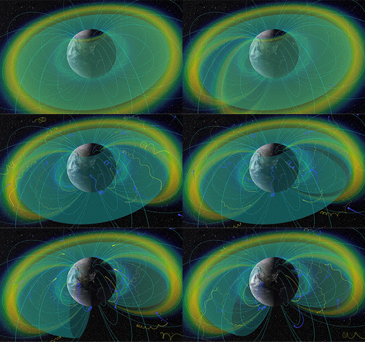
Two donuts of seething radiation that surround Earth, called the Van Allen radiation belts, have been found to contain a nearly impenetrable barrier that prevents the fastest, most energetic electrons from reaching Earth.


Image above: A cloud of cold, charged gas around Earth, called the plasmasphere and seen here in purple, interacts with the particles in Earth's radiation belts — shown in grey— to create an impenetrable barrier that blocks the fastest electrons from moving in closer to our planet. Image Credit: NASA/Goddard.

The Van Allen belts are a collection of charged particles, gathered in place by Earth’s magnetic field. They can wax and wane in response to incoming energy from the sun, sometimes swelling up enough to expose satellites in low-Earth orbit to damaging radiation. The discovery of the drain that acts as a barrier within the belts was made using NASA's Van Allen Probes, launched in August 2012 to study the region. A paper on these results appeared in the Nov. 27, 2014, issue of Nature magazine.

“This barrier for the ultra-fast electrons is a remarkable feature of the belts," said Dan Baker, a space scientist at the University of Colorado in Boulder and first author of the paper. "We're able to study it for the first time, because we never had such accurate measurements of these high-energy electrons before."

Understanding what gives the radiation belts their shape and what can affect the way they swell or shrink helps scientists predict the onset of those changes. Such predictions can help scientists protect satellites in the area from the radiation.

The Van Allen belts were the first discovery of the space age, measured with the launch of a US satellite, Explorer 1, in 1958. In the decades since, scientists have learned that the size of the two belts can change – or merge, or even separate into three belts occasionally. But generally the inner belt stretches from 400 to 6,000 miles above Earth's surface and the outer belt stretches from 8,400 to 36,000 miles above Earth's surface.

A slot of fairly empty space typically separates the belts. But, what keeps them separate? Why is there a region in between the belts with no electrons?

Enter the newly discovered barrier. The Van Allen Probes data show that the inner edge of the outer belt is, in fact, highly pronounced. For the fastest, highest-energy electrons, this edge is a sharp boundary that, under normal circumstances, the electrons simply cannot penetrate.

"When you look at really energetic electrons, they can only come to within a certain distance from Earth," said Shri Kanekal, the deputy mission scientist for the Van Allen Probes at NASA's Goddard Space Flight Center in Greenbelt, Maryland and a co-author on the Nature paper. "This is completely new. We certainly didn't expect that."

The team looked at possible causes. They determined that human-generated transmissions were not the cause of the barrier. They also looked at physical causes. Could the very shape of the magnetic field surrounding Earth cause the boundary? Scientists studied but eliminated that possibility. What about the presence of other space particles? This appears to be a more likely cause.


Animation above: This animated gif shows how particles move through Earth’s radiation belts, the large donuts around Earth. The sphere in the middle shows a cloud of colder material called the plasmasphere. New research shows that the plasmasphere helps keep fast electrons from the radiation belts away from Earth. Image Credit: NASA/Goddard/Scientific Visualization Studio.

The radiation belts are not the only particle structures surrounding Earth. A giant cloud of relatively cool, charged particles called the plasmasphere fills the outermost region of Earth's atmosphere, beginning at about 600 miles up and extending partially into the outer Van Allen belt. The particles at the outer boundary of the plasmasphere cause particles in the outer radiation belt to scatter, removing them from the belt.

This scattering effect is fairly weak and might not be enough to keep the electrons at the boundary in place, except for a quirk of geometry: The radiation belt electrons move incredibly quickly, but not toward Earth. Instead, they move in giant loops around Earth. The Van Allen Probes data show that in the direction toward Earth, the most energetic electrons have very little motion at all – just a gentle, slow drift that occurs over the course of months. This is a movement so slow and weak that it can be rebuffed by the scattering caused by the plasmasphere.

Radiation Belts & Plasmapause

Video above: Visualisation of the radiation belts with confined charged particles (blue & yellow) and plasmapause boundary (blue-green surface). Video Credit: NASA's Scientific Visualization Studio.

This also helps explain why – under extreme conditions, when an especially strong solar wind or a giant solar eruption such as a coronal mass ejection sends clouds of material into near-Earth space – the electrons from the outer belt can be pushed into the usually-empty slot region between the belts.

"The scattering due to the plasmapause is strong enough to create a wall at the inner edge of the outer Van Allen Belt," said Baker. "But a strong solar wind event causes the plasmasphere boundary to move inward."

A massive inflow of matter from the sun can erode the outer plasmasphere, moving its boundaries inward and allowing electrons from the radiation belts the room to move further inward too.

The Johns Hopkins Applied Physics Laboratory in Laurel, Maryland, built and operates the Van Allen Probes for NASA's Science Mission Directorate. The mission is the second in NASA's Living With a Star program, managed by Goddard.

For more information about the Van Allen Probe, visit: http://www.nasa.gov/vanallenprobes

Image & Animation (mentioned), Video (mentioned), Text, Credits: NASA's Goddard Space Flight Center/Karen C. Fox.

Greetings, Orbiter.ch