mardi 17 février 2015

Progress M-26M has successfully docked with the ISS


ROSCOSMOS - Russian Vehicle patch.

17.02.2015

Feb 17 at 07:57 p.m. Moscow time the cargo spacecraft Progress M-26M has successfully docked with the ISS through the Functional Cargo Block Zarya.

The docking operation was produced in the automatic mode under control of the Russian crew members of ISS and specialist from the Mission Control Center.

Progress-M space cargo

The space cargo (SC) has delivered on aloft more than 2,6 tones of different supplies, like scientific equipment, propellant components, meals and personal effects.

ROSCOSMOS Press Release: http://en.federalspace.ru/20382/

Image, Text, Credits: Press-service of Roscosmos/ROSCOSMOS/NASA.

Greetings, Orbiter.ch

Resolving to Stay Fit in Space and on Earth


ISS - International Space Station logo.

February 17, 2015

In February, our attention turns to romantic matters of the heart. As American Heart Month, this month is also a time to focus on heart health and a perfect excuse to start working out to improve your physical fitness. Astronauts on the International Space Station are working to keep their hearts healthy too, and at the same time they are generating data to advance knowledge of health and fitness in space and on Earth.

Astronauts exercise regularly while in space to maintain muscle, bone, and cardiovascular health and fitness and to remain fit and strong enough to perform physically demanding tasks such as extravehicular activity. Scientists have frequently measured the effectiveness of that exercise during short spaceflights.


Image above: Catherine (Cady) Coleman, Expedition 26 flight engineer, performs calibrations on the VO2max Portable Pulmonary Function System (PPFS). The PPFS is located next to the Cycle Ergometer with Vibration Isolation System (CEVIS) so astronauts can measure their oxygen consumption while riding the CEVIS. Image Credit: NASA.

Now, researchers have assessed exercise on longer spaceflights with the help of astronauts on the space station, measuring their VO2 peak before, during and after missions of four to five months.

Widely accepted as the best measure of cardiovascular fitness, VO2peak, also called VO2max, is a measure of peak oxygen uptake. That represents the highest amount of oxygen your body can use to produce energy during exercise. Oxygen is used by cells to provide the energy to perform work and a more aerobically fit person’s cells take up and use more oxygen, explains Meghan Downs, senior researcher at NASA’s Exercise Physiology Laboratory. 

VO2peak is measured using a bicycle test, with astronauts starting at low intensity and gradually increasing pedaling resistance over a short period of time until they could no longer pedal the bike. The tests were performed three months before launch to the space station; after approximately 15 days in space; every 30 days throughout flight; and one, 10 and 30 days following return to Earth.

According to the results, published in the Journal of Applied Physiology, VO2peak decreased by an average of 17 percent by day 15 in space, but then gradually increased during flight. Most astronauts never recovered their preflight V02peak levels during the mission, but a few were able to maintain or even improve VO2peak during flight with frequent bouts of high intensity exercise.


Image above: NASA astronaut Sunita Williams, Expedition 32 flight engineer, performs a VO2max test while using the Cycle Ergometer with Vibration Isolation System (CEVIS) in the Destiny laboratory. Image Credit: NASA.

Currently, each crew member is prescribed a two-hour daily workout using three pieces of equipment on the station. This investigation will help scientists design these individualized exercise programs. The data also will help predict what activities an astronaut should be able to tolerate after a long spaceflight, which will help in planning future missions. Astronauts with higher VO2peak levels, for example, would be better able to work in heavy spacesuits exploring an asteroid or walking around Mars.

“We now have evidence that VO2peak can be maintained during long-duration missions using available exercise hardware and prescriptions,” says Downs. “However, the hardware currently in use on the space station is simply too big and draws more power than exploration vehicles will allow. We will need to find new and creative ways to maintain astronaut health and fitness on those missions.”

One way could be interval exercise, which alternates periods of high intensity with short periods of low intensity effort. According to Mark Guilliams, head of the Astronaut Strength, Conditioning and Rehabilitation group, this approach has been shown to be effective at maintaining VO2peak in space. It also has wide-ranging applications on Earth.

International Space Station (ISS). Image Credit: NASA

“High intensity protocols are very effective in the general population,” says Stuart Lee, lead research scientist in NASA’s Cardiovascular Laboratory. “This form of exercise can benefit not just 20-year olds who want to be fit and strong, but also those in cardiac rehabilitation and pulmonary care.” An ongoing study on the station, called SPRINT, is evaluating the effectiveness of this protocol during long-duration spaceflight. 

Thanks to these investigations, improved workouts will keep astronauts fit and ready to perform, and could give the rest of us a reason to celebrate.

Related links:

American Heart Month: http://www.cdc.gov/Features/HeartMonth/

Journal of Applied Physiology: http://jap.physiology.org/content/117/3/231

SPRINT: http://www.nasa.gov/mission_pages/station/research/experiments/972.html

For more information about International Space Station (ISS), visit: http://www.nasa.gov/mission_pages/station/main/index.html

Images (mentioned), Text, Credits: NASA/International Space Station Program Office/Melissa Gaskill.

Greetings, Orbiter.ch

Voyager 1 - 'Pale Blue Dot' Images Turn 25


NASA - Voyager 1 Mission patch.

February 17, 2015

February 14 Valentine's Day is special for NASA's Voyager mission. It was on Feb. 14, 1990, that the Voyager 1 spacecraft looked back at our solar system and snapped the first-ever pictures of the planets from its perch at that time beyond Neptune.

Reflections on the Pale Blue Dot

Video above: Ann Druyan, Carl Sagan's co-author and widow, reflects on the meaning of Voyager's "pale blue dot" image of Earth. Video Credit: NASA/JPL-Caltech.

This "family portrait" captures Neptune, Uranus, Saturn, Jupiter, Earth and Venus from Voyager 1's unique vantage point. A few key members did not make it in: Mars had little sunlight, Mercury was too close to the sun, and dwarf planet Pluto turned out too dim.

Taking these images was not part of the original plan, but the late Carl Sagan, a member of the Voyager imaging team at the time, had the idea of pointing the spacecraft back toward its home for a last look. The title of his 1994 book, "Pale Blue Dot," refers to the image of Earth in this series.

"Twenty-five years ago, Voyager 1 looked back toward Earth and saw a 'pale blue dot,' " an image that continues to inspire wonderment about the spot we call home," said Ed Stone, project scientist for the Voyager mission, based at the California Institute of Technology, Pasadena.


Images above: These six narrow-angle color images were made from the first ever "portrait" of the solar system taken by Voyager 1, which was more than 4 billion miles from Earth and about 32 degrees above the ecliptic. Images Credit: NASA/JPL-Caltech.

The image of Earth contains scattered light that resembles a beam of sunlight, which is an artifact of the camera itself that makes the tiny Earth appear even more dramatic. Voyager 1 was 40 astronomical units from the sun at this moment. One astronomical unit is 93 million miles, or 150 million kilometers.

These family portrait images are the last that Voyager 1, which launched in 1977, returned to Earth. Mission specialists subsequently turned the camera off so that the computer controlling it could be repurposed. The spacecraft is still operating, but no longer has the capability to take images.


Image above: The cameras of Voyager 1 on Feb. 14, 1990, pointed back toward the sun and took a series of pictures of the sun and the planets, making the first ever "portrait" of our solar system as seen from the outside. Image Credit: NASA/JPL-Caltech.

"After taking these images in 1990, we began our interstellar mission. We had no idea how long the spacecraft would last," Stone said.

Today, Voyager 1, at a distance of 130 astronomical units, is the farthest human-made object from Earth, and it still regularly communicates with our planet. In August 2012, the spacecraft entered interstellar space – the space between the stars -- and has been delivering data about this uncharted territory ever since. Its twin, Voyager 2, also launched in 1977, is also journeying toward interstellar space.

Voyager 1 is more than three times farther from Earth than it was on Valentine's Day 25 years ago. Today, Earth would appear about 10 times dimmer from Voyager's vantage point.


Image above: This narrow-angle color image of the Earth, dubbed "Pale Blue Dot," is a part of the first ever "portrait" of the solar system taken by Voyager 1. Image Credit: NASA/JPL-Caltech.

Sagan wrote in his "Pale Blue Dot" book: "That's here. That's home. That's us. On it everyone you love, everyone you know, everyone you ever heard of, every human being who ever was, lived out their lives. … There is perhaps no better demonstration of the folly of human conceits than this distant image of our tiny world."

NASA's Jet Propulsion Laboratory, Pasadena, California, built and operates the twin Voyager spacecraft. The Voyagers Interstellar Mission is a part of NASA's Heliophysics System Observatory, sponsored by the Heliophysics Division of NASA's Science Mission Directorate in Washington.

For more information about Voyager, visit: http://voyager.jpl.nasa.gov

NASA/JPL/Elizabeth Landau.

Dawn Approaches: Two Faces of Ceres


NASA - Dawn Mission patch.

Feb. 17, 2015


These two views of Ceres were acquired by NASA's Dawn spacecraft on Feb. 12, 2015, from a distance of about 52,000 miles (83,000 kilometers) as the dwarf planet rotated. The images have been magnified from their original size.

The Dawn spacecraft is due to arrive at Ceres on March 6, 2015.

Dawn's mission to Vesta and Ceres is managed by the Jet Propulsion Laboratory for NASA's Science Mission Directorate in Washington. Dawn is a project of the directorate's Discovery Program, managed by NASA's Marshall Space Flight Center in Huntsville, Alabama. UCLA is responsible for overall Dawn mission science. Orbital ATK, Inc., of Dulles, Virginia, designed and built the spacecraft.

JPL is managed for NASA by the California Institute of Technology in Pasadena. The framing cameras were provided by the Max Planck Institute for Solar System Research, Göttingen, Germany, with significant contributions by the German Aerospace Center (DLR) Institute of Planetary Research, Berlin, and in coordination with the Institute of Computer and Communication Network Engineering, Braunschweig.

Artist's view of Dawn spacecraft heading Ceres

The visible and infrared mapping spectrometer was provided by the Italian Space Agency and the Italian National Institute for Astrophysics, built by Selex ES, and is managed and operated by the Italian Institute for Space Astrophysics and Planetology, Rome. The gamma ray and neutron detector was built by Los Alamos National Laboratory, New Mexico, and is operated by the Planetary Science Institute, Tucson, Arizona.

For more information about Dawn mission, visit: http://www.nasa.gov/mission_pages/dawn/main/

Images, Text, Credits: NASA/JPL-Caltech/UCLA/MPS/DLR/IDA

Cheers, Orbiter.ch

SMOS on acid


ESA - SMOS Mission logo.

17 February 2015

SMOS in orbit

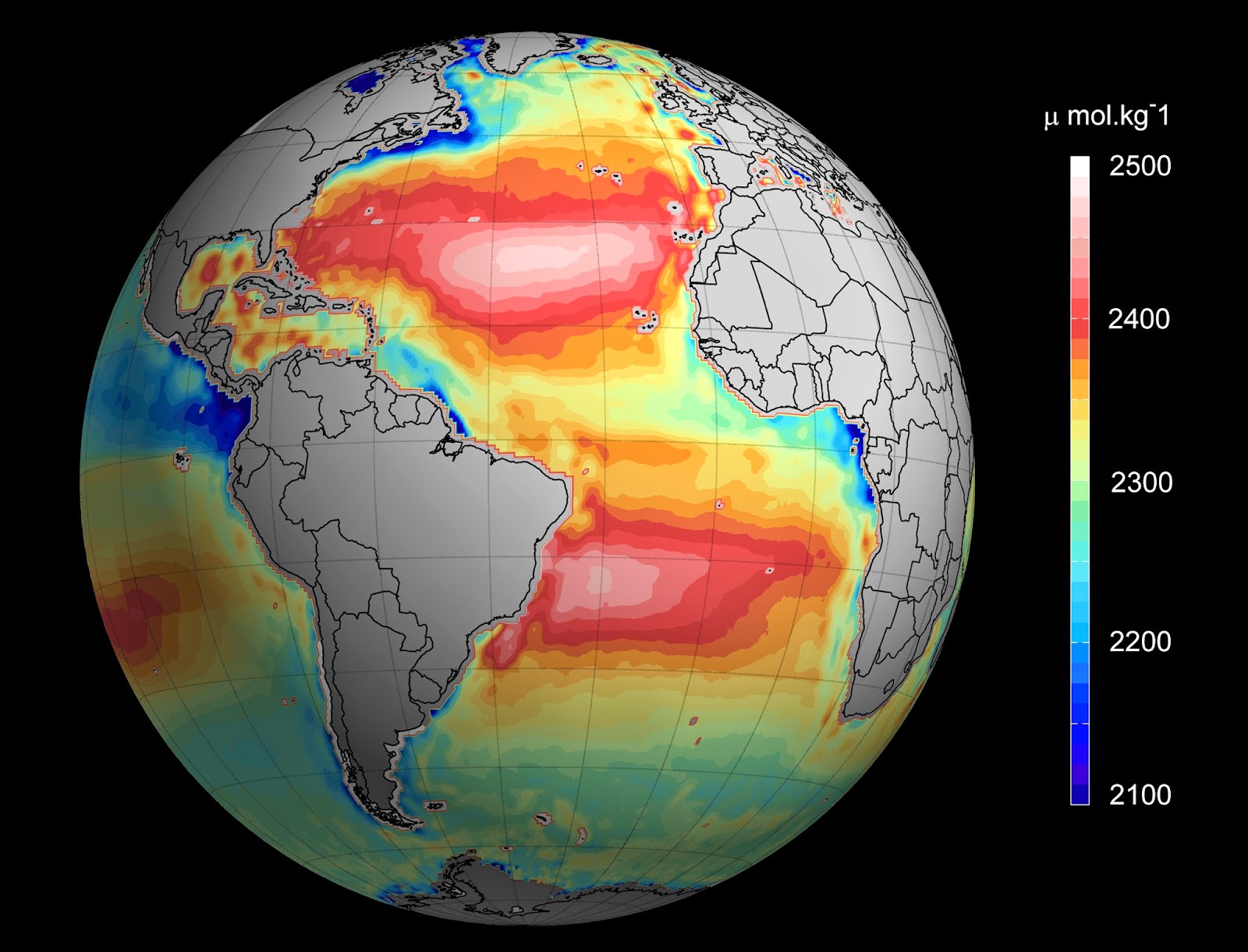
With fundamental changes happening to the chemistry of the world’s oceans, salinity information from ESA’s SMOS mission is being used with other Earth observation data to obtain information on ‘the other carbon dioxide problem’ – ocean acidification.

This new step is set to advance the way ocean biologists and climatologists study the oceans.

More than a quarter of the carbon dioxide we release into the atmosphere every year is soaked up by the oceans.

Ocean alkalinity

Initially, this may appear to be a good thing, tempering global warming, but there is a downside.

As more carbon dioxide dissolves into the oceans, the more acidic the seawater becomes – with extremely damaging effects.

Over the next century, ocean acidification has the potential to alter many marine ecosystems so that sea life is affected as well as fisheries – a basic food source on which many rely.

Carefully assessing changes in ocean acidity is essential, and particularly because these changes are not uniform around the world.

Until now, this information has only been available from measurements taken from research vessels and laboratory experiments, which is clearly limited.

Surface ocean pH

Researchers at the University of Exeter, Plymouth Marine Laboratory, Ifremer, ESA and a team of international collaborators are developing new methods that allow ocean acidity around the globe to be quantified using satellite measurements.

Piecing together salinity data from SMOS with satellite sea-surface temperature measurements and additional auxiliary data, it is possible to work out the pH of seawater and therefore provide accurate information to help address the growing problem of ocean acidification.

Roberto Sabia, Earth observation data engineer at ESA, explains, “By unifying various different efforts, for the first time we are now able to use satellites to systematically determine the pH of surface seawater.

“In particular, by capitalising on salinity measurements from SMOS, we aim to routinely generate a novel value-added data product: a global surface ocean pH atlas.”

Jamie Shutler from the University of Exeter, who is leading the research, added, “Satellites are likely to become increasingly important for monitoring ocean acidification, especially in remote waters.

Under threat

“We are pioneering this data fusion approach so that we can observe large areas of Earth’s oceans, allowing us to quickly and easily identify those areas most at risk from the increasing acidification.”

This research, which is being carried out through ESA’s Earth Observation Support to Science Element (STSE), was published today in the journal Environmental Science and Technology: http://pubs.acs.org/doi/abs/10.1021/es504849s

Lead author Peter Land, from Plymouth Marine Laboratory, said, “It is now time to evaluate how to make the most of satellite and in situ data to help us understand ocean acidification, and to establish where remotely-sensed data can make the best contribution."

Related links:

University of Exeter: http://www.exeter.ac.uk/

Plymouth Marine Laboratory: http://www.pml.ac.uk/

Sea-surface salinity remote sensing: http://www.salinityremotesensing.ifremer.fr/

Support to Science Element: http://due.esrin.esa.int/stse/

More information:

Salinity from space unlocks satellite-based assessment of ocean acidification: http://pubs.acs.org/doi/abs/10.1021/es504849s

Images, Text, Credits: ESA/R. Sabia/V. Piazza/Ifremer/CNES.

Greetings, Orbiter.ch

Soyuz-U with Progress-M26M on board was launched from the Cosmodrome Baikonur


ROSCOSMOS - Russian Vehicles patch.

17.02.2015

Soyuz-U carrying Progress M-26M launch

Feb 17 at 02:00 p.m. Moscow time the launch vehicle Soyuz-U with the space cargo (SC) Progress M-26M on board was successfully launched  from the Launch Pad N°1 of Baikonur Cosmodrome.

At 02:09 p.m. MT Progress M-26M had undocked from the third stage of  launcher vehicle (LV) and had reached the target orbit.

Soyuz-U carrying Progress M-26M launch

The docking of cargo spacecraft with the ISS is scheduled on 07:59 p.m. MT on Feb 17.

The cargo SC Progress M-26M will deliver on aloft more than 2,6 tones of different supplies, like scientific equipment, propellant components, meals and personal effects.

ROSCOSMOS Press Release: http://en.federalspace.ru/20379/

Image, Video, Text, Credits: Press-service of Roscosmos/ROSCOSMOS TV/Orbiter.ch Aerospace.

Greetings, Orbiter.ch

lundi 16 février 2015

Rosetta - Close encounter


ESA - Rosetta Mission patch.

16 February 2015

Comet on 14 February from 8.7 km

On 14 February 2015, Rosetta swooped over the surface of Comet 67P/Churyumov–Gerasimenko at a distance of just 6 km. The closest approach took place at 12:41 GMT over a region known as Imhotep, which is on the larger of the comet’s two lobes.

The image reveals the contrasting terrains seen on this comet. Layered and fractured exposed surfaces contrast against expanses of smooth, dust-covered terrain. In some places, such as to the lower right of this image, the faint outline of raised near-circular objects with smooth surfaces can be seen. Elsewhere, boulders ranging in size from a few metres to a few tens of metres are scattered across the surface. The largest boulder, seen to the upper right, is named Cheops.

14 February close flyby, 10:15 GMT

Images above: Four-image montage of Comet 67P/Churyumov–Gerasimenko comprising images taken on 14 February 2015 during the first dedicated close flyby. This image set was taken at 10:32 GMT from a distance of 12.6 km from the comet centre, or about 10.6 km from the surface seen in the foreground. Using the surface distance, the image scale is 0.9 m/pixel and the montage measures about 1.8 km across.

As well as providing the opportunity to take close-up high-resolution images of the surface, flybys like this also allow Rosetta’s instruments to sample the innermost parts of the comet’s atmosphere, or coma, to understand the connection between the source of the observed activity and the wider coma.

The spacecraft has now begun a new phase of observations, whereby it will continue to fly past at a range of distances, typically between about 15 km and 100 km.

The more distant flybys will provide the broader context of a wide-angle view of the nucleus and its growing coma as the comet moves towards perihelion – the closest approach to the Sun along its orbit. Rosetta is today 345 million kilometres from the Sun; at perihelion, on 13 August this year, it will be at about 186 million kilometres, between the orbits of Earth and Mars.

14 February close flyby, 19:42 GMT

Images above: Four-image montage of Comet 67P/Churyumov–Gerasimenko comprising images taken on 14 February 2015 during the first dedicated close flyby. This set was taken at 19:42 GMT from a distance of 31.6 km from the comet centre. The image scale is 2.7 m/pixel and the montage measures 5.5 km across.

The image presented here was taken with the navigation camera shortly after closest approach, at 14:19 GMT, from a distance of 8.7 km. It has a scale of 0.74 m/pixel and measures 0.76 km across.

For more information about Rosetta mission, visit: http://www.esa.int/Our_Activities/Space_Science/Rosetta

Images, Text, Credits: ESA/Rosetta/NavCam – CC BY-SA IGO 3.0.

Greetings, Orbiter.ch