jeudi 20 janvier 2022

NASA Solar Sail Mission to Chase Tiny Asteroid After Artemis I Launch


NASA - NEA Scout Mission patch.


Jan 20, 2022

NEA Scout will visit an asteroid estimated to be smaller than a school bus – the smallest asteroid ever to be studied by a spacecraft.

Launching with the Artemis I uncrewed test flight, NASA’s shoebox-size Near-Earth Asteroid Scout will chase down what will become the smallest asteroid ever to be visited by a spacecraft. It will get there by unfurling a solar sail to harness solar radiation for propulsion, making this the agency’s first deep space mission of its kind.


Images above: NEA Scout is composed of a small, shoebox-sized CubeSat (top left) and a thin, aluminum-coated solar sail about the size of a racquetball court (bottom left). After the spacecraft launches aboard Artemis I, the sail will use sunlight to propel the CubeSat to a small asteroid (as depicted in an illustration, right). Image Credit: NASA.

The target is 2020 GE, a near-Earth asteroid (NEA) that is less than 60 feet (18 meters) in size. Asteroids smaller than 330 feet (100 meters) across have never been explored up close before. The spacecraft will use its science camera to get a closer look, measuring the object’s size, shape, rotation, and surface properties while looking for any dust and debris that might surround 2020 GE.

Because the camera has a resolution of less than 4 inches (10 centimeters) per pixel, the mission’s science team will be able to determine whether 2020 GE is solid – like a boulder – or if it’s composed of smaller rocks and dust clumped together like some of its larger asteroid cousins, such as asteroid Bennu.

“Thanks to the discoveries of NEAs by Earth-based observatories, several targets had been identified for NEA Scout, all within the 16-to-100-foot [5-to-30-meter] size range,” said Julie Castillo-Rogez, the mission’s principal science investigator at NASA’s Jet Propulsion Laboratory in Southern California. “2020 GE represents a class of asteroid that we currently know very little about.”

2020 GE was first observed on March 12, 2020, by the University of Arizona’s Catalina Sky Survey as part of its search for near-Earth objects for NASA’s Planetary Defense Coordination Office.

NEA Scout Mission sail deployment. Animation Credit: NASA

Developed under NASA’s Advanced Exploration Systems Division by Marshall Space Flight Center in Huntsville, Alabama, and JPL, NEA Scout is a science and technology demonstration mission that will enhance the agency’s understanding of small NEAs. Using a six-unit CubeSat form factor, it will ride as one of 10 secondary payloads aboard the powerful Space Launch System (SLS) rocket, which will launch no earlier than March 2022 at NASA’s Kennedy Space Center in Florida. NEA Scout will then be deployed from a dispenser attached to the adapter ring that connects the rocket and Orion spacecraft.

The mission will act as a nimble scout for future human and robotic missions that may utilize asteroid resources – and will gain important planetary defense insights about this class of NEA.

“Although large asteroids are of most concern from a planetary defense perspective, objects like 2020 GE are far more common and can pose a hazard to our planet, despite their smaller size,” said Castillo-Rogez. The Chelyabinsk meteor was caused by a small asteroid about 65 feet (20 meters) in diameter – it exploded over the Russian city on Feb. 15, 2013, creating a shockwave that broke windows all over the city and injured more than 1,600 people. That was the same class of NEA as 2020 GE.

Low Mass, High Performance

Learning more about asteroid 2020 GE is only part of NEA Scout’s job. It will also demonstrate solar sail technology for deep space encounters. When released from its dispenser after launch, the spacecraft will use stainless steel alloy booms to unfurl a solar sail that will expand from a small package to a sail about the size of a racquetball court, or 925 square feet (86 square meters).

Made from plastic-coated aluminum thinner than a human hair, this lightweight, mirror-like sail will generate thrust by reflecting solar photons – quantum particles of light radiating from the Sun. The sail will provide most of NEA Scout’s propulsion, but small cold-gas thrusters with a limited propellant supply will also assist with maneuvers and orientation.

“The genesis of this project was a question: Can we really use a tiny spacecraft to do deep space missions and produce useful science at a low cost?” said Les Johnson, the mission’s principal technology investigator at Marshall. “This is a huge challenge. For asteroid characterization missions, there’s simply not enough room on a CubeSat for large propulsion systems and the fuel they require.”

Sunlight acts as a constant force, so a tiny spacecraft equipped with a large solar sail can eventually travel many miles per second. Solar sails are a high-performance propulsion system for low-mass and low-volume spacecraft, according to Johnson. NEA Scout will maneuver by tipping and tilting its sail to change the angle of sunlight, altering the amount of thrust and direction of travel, similar to how a boat uses the wind to sail.

In September 2023, asteroid 2020 GE will make a close approach with Earth, and with a gravitational assist from the Moon, NEA Scout will have gathered enough speed to catch up. Mission navigators will fine-tune NEA Scout’s trajectory before the spacecraft approaches within a mile of the asteroid.

“NEA Scout will accomplish probably the slowest flyby of an asteroid ever – at a relative speed of less than 100 feet [30 meters] per second,” said Castillo-Rogez. “This will give us a few hours to gather invaluable science and allow us to see what asteroids of this class look like up close.”

NEA Scout sets the stage for future solar sails: NASA’s Advanced Composite Solar Sail System will demonstrate novel, lightweight booms to deploy a solar sail from a CubeSat following its 2022 launch. After that, Solar Cruiser, an 18,000-square-foot (nearly 1,700-square-meter) solar sail technology demonstration, will use sunlight to travel toward the Sun in 2025, enabling future missions to better monitor space weather.

For more about the NEA Scout mission, visit: https://www.nasa.gov/content/nea-scout

Related links:

Catalina Sky Survey: https://catalina.lpl.arizona.edu/

Planetary Defense Coordination Office: https://www.nasa.gov/planetarydefense

Advanced Exploration Systems Division: https://www.nasa.gov/directorates/heo/aes/index.html

Advanced Composite Solar Sail System: https://www.nasa.gov/directorates/spacetech/small_spacecraft/ACS3

Image (mentioned), Animation (mentioned), Text, Credits: NASA/Naomi Hartono/Marshall Space Flight Center/Molly Porter/JPL/Ian J. O’Neill.

Best regards, Orbiter.ch

Mega iceberg released 152 billion tonnes of freshwater


ESA - ERS Mission logo.


Jan 20, 2022

In July 2017, a giant iceberg, named A-68, snapped off Antarctica’s Larsen-C ice shelf and began an epic journey across the Southern Ocean. Three and a half years later, the main part of iceberg, A-68A, drifted worryingly close to South Georgia. Concerns were that the berg would run aground in the shallow waters offshore. This would not only cause damage to the seafloor ecosystem but also make it difficult for island wildlife, such as penguins, to make their way to the sea to feed. Using measurements from satellites, scientists have charted how A-68A shrunk towards the end of its voyage, which fortunately prevented it from getting stuck. However, the downside is that it released a colossal 152 billion tonnes of freshwater close to the island, potentially having a profound effect on the island’s marine life.

When A-68 was spawned, it had a surface area of more than twice the size of Luxemburg – one of the largest icebergs on record.

It lost a chunk of ice almost immediately after being calved, resulting in the larger berg being renamed A-68A, and its offspring became A-68B. In April 2020, A-68A lost another chunk subsequently called A-68C.

Antarctic icebergs are named from the Antarctic quadrant in which they were originally sighted, then a sequential number, and then if the iceberg breaks, a sequential letter is added.

A-68 drift from Antarctica to South Georgia

For the first two years of its life, A-68A stayed in the cold waters of the Weddell Sea close to its parent ice shelf. Here, it experienced little in the way of melting.  However, once the berg began its northward journey across the Drake Passage, it travelled through increasingly warm waters and began to melt.

Altogether, the A-68A iceberg thinned by 67 metres from its initial thickness of 235 metres, with the rate of melting rising sharply as the berg drifted in the Scotia Sea around South Georgia.

A paper published in Remote Sensing of Environment describes how researchers from the Centre for Polar Observation and Modelling in the UK and the British Antarctic Survey combined measurements from different satellites to chart how A-68A changed in area and thickness throughout its life cycle.

A68’s journey

The journey of A-68A was charted using observations from five different satellite missions.

To track how the area of A-68A changed, they used optical imagery from the Copernicus Sentinel-3 mission and from the MODIS instrument on the US Terra mission, along with radar data from the Copernicus Sentinel-1 mission. While the Sentinel-1 radar imagery offers all-weather capability and higher spatial resolution, MODIS and Sentinel-3 optical imagery have higher temporal resolution but cannot be used during the polar night and on cloudy days.

To measure changes in the iceberg’s freeboard, or the height of the ice above the sea surface, they used data from ESA’s CryoSat mission and from the US ICESat-2 mission. Knowing the freeboard of the ice means that the thickness of the entire iceberg can be calculated.

All these measurements together allowed the scientists to calculated how the iceberg’s volume changed and therefore how much freshwater it released.

Tommaso Parrinello, ESA’s CryoSat Mission Manager, said, “Our ability to study every move of the iceberg in such detail is thanks to advances in satellite techniques and the use of a variety of measurements. Imaging satellites record the shape of the iceberg and data from altimetry missions like CryoSat add another important dimension as they measure the height of surfaces – which is essential for calculating changes in volume.”

Visualising the amount of freshwater released from A-68A

The new study reveals that A-68A collided only briefly with the sea floor and broke apart shortly afterwards, making it less of a risk in terms of blockage.  By the time it reached the shallow waters around South Georgia, the iceberg’s keel had reduced to 141 metres below the ocean surface, shallow enough to just avoid the seabed which is around 150 metres deep.

If an iceberg’s keel is too deep it can get stuck on the sea floor. This can be disruptive in many ways; the scour marks can destroy fauna, and the berg itself can block ocean currents and predator foraging routes.

However, a side effect of the melting was the release of a colossal 152 billion tonnes of freshwater close to the island – a disturbance that could have a profound impact on the island’s marine habitat.

When icebergs detach from ice shelves, they drift with the ocean currents and wind, releasing cold fresh meltwater and nutrients as they melt. This process influences the local ocean circulation and fosters biological production around the iceberg.

A-68A’s position on 17 December

Anne Braakmann-Folgmann, PhD candidate at the Centre for Polar Observation and Modelling and lead author of the study said, “This is a huge amount of meltwater, and the next thing we want to learn is whether it had a positive or negative impact on the ecosystem around South Georgia.

“Because A-68A took a common route across the Drake Passage, we hope to learn more about icebergs taking a similar trajectory, and how they influence the polar oceans.”

Related links:

ERS-1 & ERS-2: https://www.esa.int/Applications/Observing_the_Earth/ERS_1_2_tandem_mission

Observing the Earth: https://www.esa.int/Applications/Observing_the_Earth

Images, Video, Text, Credits: ESA/British Antarctic Survey/Contains modified Copernicus Sentinel data (2021), processed by ESA; Antarctic Iceberg Tracking Database/CPOM/GEBCO Compilation Group/WOA/Antarctic Tracking Database/CPOM/ESA/Google basemap.

Greetings, Orbiter.ch

mercredi 19 janvier 2022

Cosmonauts Wrap Up Spacewalk after Russian Module Work


ROSCOSMOS - Russian Cosmonauts patch.


Jan 19, 2022

Russian cosmonauts Anton Shkaplerov and Pyotr Dubrov of Roscosmos concluded their spacewalk at 2:28 p.m. EST after 7 hours and 11 minutes.


Image above: Cosmonauts (from left) Anton Shkaplerov and Pyotr Dubrov are conducting the first spacewalk of 2022. Image Credits: ROSCOSMOS/NASA.

Shkaplerov, designated extravehicular crew member 1 (EV1), is wearing a Russian Orlan spacesuit with red stripes, and Dubrov is wearing a spacesuit with blue stripes as extravehicular crew member 2 (EV2).


Image above: Cosmonauts (from left) Anton Shkaplerov and Pyotr Dubrov are pictured in their Russian Orlan spacesuits for a fit check and leak checks on Jan. 14. Image Credits: ROSCOSMOS/NASA.

Shkaplerov and Dubrov completed their major objectives for today to ready the new Prichal module for future Russian visiting spacecraft. The cosmonauts installed handrails, rendezvous antennas, a television camera, and docking targets on Prichal, which automatically docked to the Nauka multipurpose laboratory module in November.

Russian Spacewalk to Outfit Nauka Module in space

This was the first spacewalk this year and the 246th overall in support of space station assembly, maintenance and upgrades. Spacewalkers have now spent a total of 64 days, 19 hours, and 37 minutes working outside the station.


Image above: Cosmonaut Pyotr Dubrov works to configure and activate the Prichal module during a spacewalk on Jan. 19, 2022. Image Credit: NASA TV.

This was the third spacewalk in Shkaplerov’s career, who has now spent a total of 21 hours and 39 minutes spacewalking, and the fourth for Dubrov, bringing his total to 29 hours and 49 minutes of spacewalk time.

Additional spacewalks are planned this spring to outfit a European robotic arm on the Nauka laboratory and to activate Nauka’s airlock for future spacewalk activity.

Related links:

Nauka multipurpose laboratory module:  https://www.roscosmos.ru/tag/nauka/

Space Station Research and Technology: https://www.nasa.gov/mission_pages/station/research/overview.html

International Space Station (ISS): https://www.nasa.gov/mission_pages/station/main/index.html

Images (mentioned) Video (NASA TV), Text, Credits: NASA/Mark Garcia.

Best regards, Orbiter.ch

SpaceX Starlink 35 launch


SpaceX - Falcon 9 / Starlink Mission patch.


Jan 19, 2022

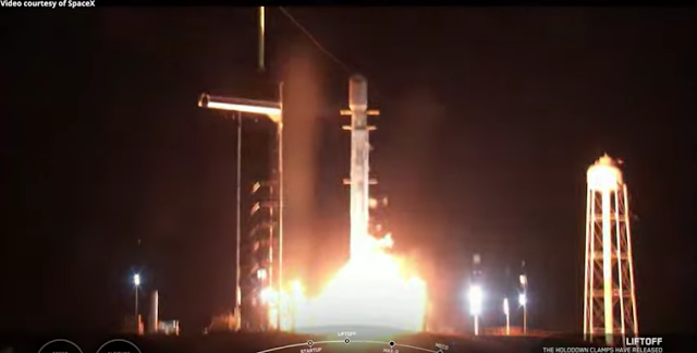
SpaceX Starlink 35 liftoff

A SpaceX Falcon 9 rocket launched 49 Starlink satellites (Starlink-35) from Launch Complex 39A (LC-39A) at Kennedy Space Center in Florida, on 19 January 2022, at 02:02 UTC (18 January, at 21:02 EST).

SpaceX Starlink 35 launch & Falcon 9 first stage landing, 19 January 2022

Following stage separation, Falcon 9’s first stage landed on the “A Shortfall of Gravitas” droneship, stationed in the Atlantic Ocean. Falcon 9’s first stage (B1060) previously supported nine missions: Transporter-2, GPS-III Space Vehicle 03, Turksat 5A and six Starlink missions.

Related links:

SpaceX: https://www.spacex.com/

Starlink: https://www.starlink.com/
 
Image, Video, Text, Credits: SpaceX/SciNews/Orbiter.ch Aerospace/Roland Berga.

Best regards, Orbiter.ch

Hunga Tonga-Hunga Ha‘apai Erupts


Natural Disasters logo.


Jan 19, 2022

A powerful volcanic eruption has obliterated a small, uninhabited South Pacific island known as Hunga Tonga-Hunga Ha‘apai. Damage assessments are still ongoing, but preliminary reports indicate that some communities in the island nation of Tonga have been severely damaged by volcanic ash and significant tsunami waves.


The volcano had sporadically erupted multiple times since 2009. The most recent activity began in late December 2021 as a series of Surtseyan eruptions built up and reshaped the island, while sending bursts of tephra and volcanic gases spewing from the vent. Relatively powerful blasts shook Hunga Tonga-Hunga Ha‘apai on January 13, but it was an even more intense series of explosions early on January 15 that generated atmospheric shock waves, sonic booms, and tsunami waves that traveled the world.

Several Earth-observing satellites collected data during and after the eruption. Scientists affiliated with NASA’s Disasters program are now gathering imagery and data, and they are sharing it with colleagues around the world, including disaster response agencies.

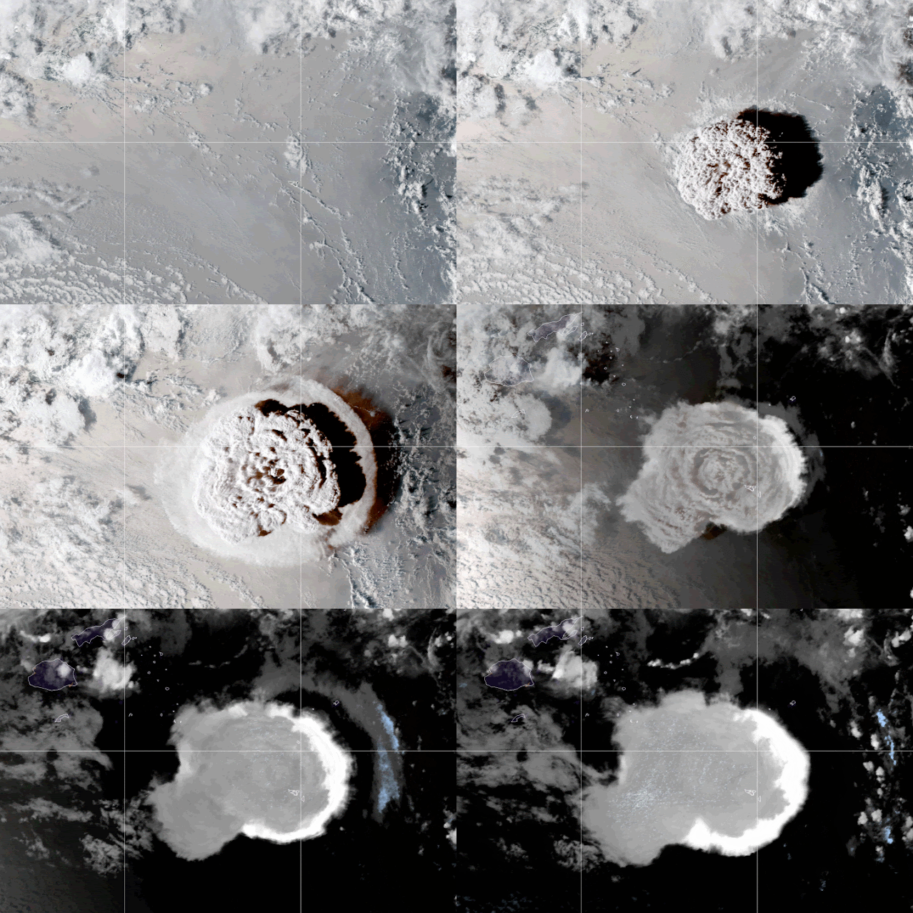
The sheer power of the eruption was quickly apparent in satellite imagery. As shown in the animation above, a vast plume of material created what volcanologists call an umbrella cloud with crescent-shaped bow shock waves and a vast number of lightning strikes.

“The umbrella cloud was about 500 kilometers (300 miles) in diameter at its maximum extent,” said Michigan Tech volcanologist Simon Carn. “That is comparable to Pinatubo and one of the largest of the satellite era. However, the involvement of water in the Tonga eruption may have increased the explosivity compared to a purely magmatic eruption like Pinatubo.”

NOAA's Geostationary Operational Environmental Satellite 17 (GOES-17) captured the images for the animation above. The natural-color views from the satellite’s Advanced Baseline Imager were acquired between 5 and 8 p.m. local time (04:00 to 07:00 Universal Time) as the volcanic plume expanded upward and outward over the South Pacific. (NASA builds and launches the GOES series of satellites for NOAA.)


The second image, based on data collected on January 16 by the Cloud-Aerosol Lidar and Infrared Pathfinder Satellite Observations (CALIPSO) mission, shows material from the eruption rising to an altitude of 31 kilometers (19 miles). Other CALIPSO data collected on January 15 indicates that a small amount of ash and gas may have reached as high as 39.7 kilometers (24.7 miles).

“This is by far the highest volcanic plume we've ever measured with CALIPSO,” said Jason Tackett, a researcher at NASA’s Langley Research Center. CALIPSO was launched in 2006 by NASA and France’s National Centre for Space Studies (CNES).

The eruption was powerful enough to inject volcanic material into the stratosphere, which generally begins above 15 kilometers (9 miles) in this part of the world. Scientists watch closely when volcanic materials reach this relatively dry layer of the atmosphere because particles linger much longer and travel much farther than if they remain in the lower, wetter troposphere. If enough volcanic material reaches the stratosphere, it can start to exert a cooling influence on global temperatures.

Despite the extreme height of the January 15 plume, scientists do not expect it to have much impact on climate. Satellite observations indicate the eruption injected about 0.4 teragrams of sulfur dioxide into the upper atmosphere, but the threshold for climate impacts is about 5 teragrams. “It is not unlike a dozen other eruptions that have occurred in the past 20 years in terms of likely impacts on climate,” explained Brian Toon, an atmospheric scientist at the University of Colorado. “It is possible the impacts will be observable in very closely studied data (when the effects of La Niña and El Niño are removed), but the impacts will be too small to be felt by the average person.”


Why this eruption was so violent is not clear yet. “With something this explosive, it is typically a consequence of a large volume of seawater coming into contact with a large reservoir of magma in a confined geologic setting,” explained Daniel Slayback, a NASA scientist who visited Hunga Tonga-Hunga Ha‘apai in 2019 to study how erosion was affecting the youngest parts of the island. Understanding erosion processes around volcanic features on Earth provides insights into how related processes may have played out in other parts of the solar system, including Mars.

Preliminary imagery from commercial satellites and European and Canadian radar imagers suggest that little of Hunga Tonga-Hunga Ha‘apai still stands above the water line. The volcanic island first rose from the sea in January 2015. Eruptive activity built up ash around a new volcanic cone and connected the older, more lava-based islands of Hunga Tonga and Hunga Ha‘apai to create Hunga Tonga-Hunga Ha‘apai.

Signs of the island’s recent demise were easy for satellites to spot in the seas. The trio of natural-color images above shows how sediment, ash, pumice, and possibly continuing emissions from the volcano discolored the water in the days after the event. The images were acquired by the Moderate Resolution Imaging Spectroradiometer (MODIS) on NASA’s Aqua satellite.

The geologic record suggests Hunga Tonga may have produced large explosive eruptions like this in the past. “I just didn't expect to see one happen quite so soon,” said Slayback. “It was a beautiful little island with a thriving ecosystem of grasses, tropical birds, and other wildlife.”

Editor’s Note:

This story was updated on January 19, 2022, to add more context and quotes from scientists studying the volcano.

Related article:

Tonga eruption heard in New Zealand, pressure waves picked up in Europe
https://orbiterchspacenews.blogspot.com/2022/01/tonga-eruption-heard-in-new-zealand.html

Related links:

CALIPSO: https://www-calipso.larc.nasa.gov/

EOSDIS LANCE: https://earthdata.nasa.gov/lance

GIBS/Worldview: https://worldview.earthdata.nasa.gov/

Suomi National Polar-orbiting Partnership: https://www.nasa.gov/mission_pages/NPP/main/index.html

National Environmental Satellite, Data, and Information Service (NESDIS): https://www.nesdis.noaa.gov/

References & Resources

- The Conversation (2022, January 15) Why the volcanic eruption in Tonga was so violent, and what to expect next. Accessed January 18, 2022.
https://theconversation.com/why-the-volcanic-eruption-in-tonga-was-so-violent-and-what-to-expect-next-175035

- Discover (2022, January 15) Major Blast in Tonga Create Tsunami and Heavy Ash Fall. Accessed January 18, 2022.
https://www.discovermagazine.com/planet-earth/major-blast-in-tonga-create-tsunami-and-heavy-ash-fall

- NASA Earth Expeditions (2019) Tonga. Accessed January 18, 2022.
https://blogs.nasa.gov/earthexpeditions/tag/tonga/

- NASA Earth Observatory (2022) Undersea Eruption Near Tonga.
https://earthobservatory.nasa.gov/images/event/85016/undersea-eruption-near-tonga

- Smithsonian Institution Global Volcanism Program (2022) Hunga Tonga-Hunga Ha‘apai. Accessed January 18, 2022.
https://volcano.si.edu/volcano.cfm?vn=243040

- University of Wisconsin-Madison (2022, January 15) Explosive eruption of the Hunga Tonga volcano. Accessed January 18, 2022.
https://cimss.ssec.wisc.edu/satellite-blog/archives/44252

- International Charter Space & Major Disasters (2022, January 15) Volcanic eruption in Tonga and Pacific. Accessed January 18, 2022.
https://disasterscharter.org/web/guest/activations/-/article/ocean-wave-in-tonga-activation-744-

- National Geographic (2022, January 15) The Tonga eruption explained, from tsunami warnings to sonic booms. Accessed January 18, 2022.
https://www.nationalgeographic.com/science/article/the-science-behind-the-tonga-eruption-and-tsunami

- NPR (2022, January 18) NASA scientists estimate Tonga blast at 10 megatons. Accessed January 18, 2022.
https://www.npr.org/2022/01/18/1073800454/nasa-scientists-estimate-tonga-blast-at-10-megatons

Credits: NASA Earth Observatory images by Joshua Stevens and Lauren Dauphin, using CALIPSO data from NASA/CNES, MODIS and VIIRS data from NASA EOSDIS LANCE and GIBS/Worldview and the Suomi National Polar-orbiting Partnership, and GOES imagery courtesy of NOAA and the National Environmental Satellite, Data, and Information Service (NESDIS). Story by Adam Voiland, with Mike Carlowicz.

Greetings, Orbiter.ch

Wanted: recycling methods to keep astronauts alive


ESA - European Space Agency emblem.


Jan 19, 2022

ESA astronaut Thomas Pesquet helping grow chilli peppers on ISS

It took a crop of potatoes to keep Matt Damon alive on the red planet in The Martian. And in future, real life astronauts on the Moon and Mars will have to be gardeners, farmers and expert recyclers as well as explorers. Do you have promising ideas that might help them to get by in space on next to no resources?

International Space Station (ISS)

While human settlements on the Moon and Mars are still to come – along with a planned Mars Transit habitat – the fundamentals of living in space are already being clear. To make such plans sustainable over the long term, settlers will have to recycle their air, water and nutrients as much as possible, to minimise their reliance on long, costly supply lines back to their distant home planet.

So ESA and the European Innovation Council – the new body guiding the commercialisation of high-risk, high-impact technologies in Europe – are teaming up to crowd source ideas for implementing ‘circular economy’ technologies and sustainable processes in space.

Reuse and recycling in space

The aim is to seek out concepts targeting the reuse and recycling of water, food, oxygen, nitrogen and other scarce resources from apparent waste material. And further to their use in space, these solutions should also have wider uses on Earth, creating synergies with terrestrial moves towards a circular economy.

On the ISS all available water is recycled

The underlying idea is not new. The International Space Station already recycles all the water it can, including crew urine, sweat, moisture from wet towels, even the humidity from astronauts’ breathing.

And for more than three decades now the ESA-led Micro-Ecological Life Support Alternative, MELiSSA Foundation has investigated the designing ‘regenerative’ or closed loop life support systems for crewed missions into deep space.

MELiSSA processes

On Earth we get all the oxygen, water and food we need from Earth’s ecosystem. Future explorers can’t take all of that ecosystem into space with them, but perhaps they can reproduce some key elements.

The 11-nation MELiSSA effort has established a ‘pilot plant’ in Barcelona of interlinked airtight compartments based on aquatic terrestrial ecosystems.

Life-supporting pilot plant

This includes a bioreactor containing ‘nitrifying’ bacteria and an algae-based photo-bioreactor, which have succeeded in keeping crews of rats alive and comfortable for almost six months at a time. The bacteria transform the urine to feed the algae while the algae take the carbon dioxide exhaled by the rats and convert it into fresh oxygen.

The wider MELiSSA Foundation has resulted so far in hundreds of academic papers, patents and terrestrial spin-offs in areas ranging from food preparation to water purification and microbial safety – along with numerous experiments flown aboard the International Space Station.

Send us your ideas

Algae bioreactor building facade based on MELiSSA technology

Guided in part by MELiSSA experience, ESA and the EIC have selected four dedicated challenges:

• Circular System Design Methodology - relating to the different approaches and design guidelines that can be used to create, simulate and predict robust circular systems

• Circular Waste Management - relating to specific processes for the recycling and reuse of wastes

• Circular Urine Management - including urine recovery/recycling systems and urine to food processes

• Circular Food Management - including biomass production processing/preparation/optimisation, new food sources, food production, recipes, processes and safety.

Within these areas, ideas are being sought for critical technology building blocks, policy, legislation and investment frameworks. Ideas will be evaluated, and the winning contributors will be invited to a workshop, which aims to produce joint strategy proposal for the coming decade.

Future Moon base

Wane to get involved? More details on the submission process and challenges are provided in the letter of invitation and proposal template. Anyone interested can also watch a recorded webinar and write direct to EIC-ESA.WhitePaper@ec.europa.eu to deal with any questions and clarifications.

Related links:

European Innovation Council: https://eic.ec.europa.eu/index_en

Mars Transit habitat: https://www.youtube.com/watch?v=LCrqrHe2hSc

MELiSSA Foundation: https://www.melissafoundation.org/

Space Engineering & Technology: https://www.esa.int/Enabling_Support/Space_Engineering_Technology

Images, Animation, Text, Credits: ESA/NASA/T. Pesquet/P. Carril/UAB/In Vivo.

Greetings, Orbiter.ch

mardi 18 janvier 2022

Crew Gets Ready for Spacewalk and Dragon Departure This Week


ISS - Expedition 66 Mission patch.


Jan 18, 2022

The Expedition 66 crew is getting ready for a spacewalk on Wednesday while packing a U.S. resupply ship for its departure on Friday. Meanwhile, the International Space Station also hosted a pair of space biology studies exploring exercise and vision.

Cosmonauts Anton Shkaplerov and Pyotr Dubrov finalized their preparations today for the first spacewalk of 2022 set to begin at 7 a.m. EST on Wednesday. The duo completed reviewing the procedures they will use during the seven-hour spacewalk to outfit Russia’s new Nauka and Prichal modules. They will wear their Russian Orlan spacesuits and exit the Poisk module’s airlock at 7 a.m. where their spacewalking gear is staged.  NASA TV, on the NASA app and the agency’s website, will broadcast the space activities live beginning at 6 a.m.


Image above: Cosmonaut Pyotr Dubrov is pictured during a spacewalk on Sept. 3, 2021, to begin outfitting Russia’s Nauka multipurpose laboratory module. Image Credits/NASA/ROSCOSMOS.

Three NASA astronauts continued loading the SpaceX Cargo Dragon vehicle ahead of its undocking on Friday at 10:40 a.m. Flight Engineers Mark Vande Hei and Raja Chari started the loading after lunch time, before NASA astronaut Thomas Marshburn joined them at the end of the day to help organize and secure the cargo.

Marshburn, along with astronaut Matthias Maurer from ESA (European Space Agency), also participated in an workout session on the exercise cycle located in the U.S. Destiny laboratory module. The duo took turns pedaling for an hour each wearing monitors that measured their heart rate for a human research study.

Crown aurora borealis

Video above: Timelapse video made during ESA astronaut Thomas Pesquet’s second mission to the International Space Station, “Alpha” around 4 November 2021. The camera was setup to take pictures at intervals of two a second, and the pictures are then edited into this video that plays at 25 pictures a second. The video is around 12 times faster than real speed. Video Credits: ESA/Thomas Pesquet.

Maurer then joined NASA Flight Engineer Kayla Barron for the rest of the day inside the Kibo laboratory module for a vision investigation. The pair conducted the research operations using the Life Science Glovebox to understand how a long-term space mission affects an astronaut’s visual function and to promote eye health on Earth.

Axiom Mission 1, the first private astronaut mission to the International Space Station, is now targeting to launch March 31 to account for additional spacecraft preparations and space station traffic. Once aboard the orbiting laboratory, the four-person Axiom Space crew will conduct science, outreach, and commercial activities for eight days before their return to Earth.

Related links:

NASA TV: https://www.nasa.gov/live

Expedition 66: https://www.nasa.gov/mission_pages/station/expeditions/expedition66/index.html

Poisk module: https://www.nasa.gov/mission_pages/station/structure/elements/poisk-mini-research-module-2

U.S. Destiny laboratory module: https://www.nasa.gov/mission_pages/station/structure/elements/us-destiny-laboratory

Kibo laboratory module: https://www.nasa.gov/mission_pages/station/structure/elements/japan-kibo-laboratory

Life Science Glovebox: https://www.nasa.gov/mission_pages/station/research/experiments/explorer/Facility.html?#id=7676

Visual function: https://www.nasa.gov/mission_pages/station/research/experiments/explorer/Investigation.html?#id=7930

Nauka multipurpose laboratory module:  https://www.roscosmos.ru/tag/nauka/

Space Station Research and Technology: https://www.nasa.gov/mission_pages/station/research/overview.html

International Space Station (ISS): https://www.nasa.gov/mission_pages/station/main/index.html

Image (mentioned), Video (mentioned), Text, Credits: NASA/Heidi Lavelle.

Best regards, Orbiter.ch