mercredi 1 juin 2022

NASA’s MAVEN Spacecraft Resumes Science & Operations, Exits Safe Mode


NASA - MAVEN Mission patch.


Jun 1, 2022

NASA’s Mars Atmosphere and Volatile EvolutioN, or MAVEN, mission returned to normal science and relay operations on May 28, 2022, after recovering from an extended safe mode event. The spacecraft encountered problems in February with its Inertial Measurement Units (IMUs). The mission team successfully diagnosed the issue with these navigation instruments and developed a system for the spacecraft to navigate by the stars, which should allow for continued MAVEN mission operations through the next decade.


Image above: Mars Atmosphere and Volatile EvolutioN, or MAVEN. Image Credit: NASA.

“This was a critical challenge facing the mission, but thanks to the work of our spacecraft and operations team, MAVEN will continue producing important science and operating as a relay for the surface assets through the end of the decade,” said Shannon Curry, MAVEN’s principal investigator at the University of California, Berkeley. “I couldn’t be prouder of our team.”

MAVEN launched in November 2013 and entered orbit around Mars in September 2014. The mission’s goal is to explore the planet’s upper atmosphere, ionosphere, and interactions with the Sun and solar wind to explore the loss of the Martian atmosphere to space. Understanding atmospheric loss gives scientists insight into the history of Mars' atmosphere and climate, liquid water, and planetary habitability. MAVEN’s primary mission was one year in duration. It has since far surpassed that and was recently approved for its fifth extended mission.

Safe mode event

On Tuesday, Feb. 22, 2022, the team lost contact with the spacecraft after it performed a routine scheduled power cycle of IMU-1. IMUs are used to determine the spacecraft’s attitude in space by measuring its rate of rotation. MAVEN has two identical IMUs on board: IMU-1 is the primary unit, and IMU-2 is the back-up unit. Once contact with the spacecraft was restored, engineering telemetry showed that the spacecraft was unable to determine its attitude from either IMU. In response, the spacecraft performed a computer reboot but could still not determine its orientation. As a last resort, the spacecraft swapped to the backup computer, which allowed MAVEN to get accurate readings from IMU-2. The spacecraft entered “safe mode,” where it ceased all planned activities, including science and relay operations, and awaited further instructions from the ground.

The team had already been working to develop all-stellar mode – a system to navigate by the stars without IMUs – to be implemented in October 2022 because IMU-1 had previously shown anomalies and IMU-2 was nearing the end of its lifespan. The development and switch to all-stellar mode is a standard practice when IMUs degrade on aging orbiters.

“This was a situation that no one initially anticipated, but the spacecraft performed as designed,” said Micheal Haggard, the Lockheed Martin MAVEN spacecraft team lead in Littleton, Colorado. “By the time we ended up on the backup computer, the spacecraft had been attempting to fix the problem with IMU-1 for about 78 minutes. We ended up on IMU-2, and the pressure was on to get the all-stellar mode ready as quickly as possible.”

A race against time  

In the following months, the spacecraft team at Lockheed Martin worked to expedite the development of software to enable all-stellar mode, since the predicted lifetime of IMU-2 would not last until October. On April 19, five months ahead of schedule, the spacecraft team completed development and uplinked the software patch to MAVEN. As soon as the code was uplinked, IMU-2 was powered off, preserving its remaining life for future spacecraft needs. Following the uplink, a series of tests were performed to verify the functionality of all-stellar mode, since the code had not previously been tested in flight.

“The team really stepped up to an existential threat,” said Rich Burns, the MAVEN project manager at NASA’s Goddard Space Flight Center in Greenbelt, Maryland. “When we recognized in the fall that IMU-2 was degrading, we knew we were going to have to shorten the schedule for all-stellar mode. The spacecraft team rose to the challenge, working under intense pressure after the anomaly.”

Once all-stellar mode was uplinked, the spacecraft and science teams powered on the instruments and configured them for science operation. All instruments were healthy and successfully resumed observations; however, the spacecraft was constrained to pointing at the Earth until testing of all-stellar mode was completed, so the instruments were not oriented as they normally would be during science operations. Nevertheless, some limited science was still possible, and MAVEN even observed a coronal mass ejection impact Mars less than two days after the instruments were powered on.

Onwards to science and relay

MAVEN returned to nominal science and relay operations on Saturday, May 28, 2022, after successfully transitioning to full all-stellar navigation.

The MAVEN spacecraft continues to operate successfully using all-stellar mode. Typically, there are certain times each year that IMUs must be used, so the team will need to continue finding innovative ways to control the spacecraft's orientation. This will ensure that MAVEN can keep operating through its extended mission lifetime, which will enable the orbiter to continue to make observations during the most extreme conditions in the Martian atmosphere that the mission has so far encountered.

MAVEN’s principal investigator is based at the University of California, Berkeley, while NASA’s Goddard Space Flight Center in Greenbelt, Maryland, manages the MAVEN mission. Lockheed Martin Space built the spacecraft and is responsible for mission operations. NASA’s Jet Propulsion Laboratory in Pasadena, California, provides navigation and Deep Space Network support. The Laboratory for Atmospheric and Space Physics at the University of Colorado Boulder is responsible for managing science operations and public outreach and communication.

Related link:

MAVEN (Mars Atmosphere and Volatile Evolution): https://www.nasa.gov/mission_pages/maven/main/index.html

Image (mentioned), Text, Credits: NASA/Jamie Adkins/Laboratory for Atmospheric and Space Physics, University of Colorado Boulder/MAVEN Communications Lead/Willow Reed.

Greetings, Orbiter.ch

NASA Partners with Industry for New Spacewalking, Moonwalking Services


NASA - ARTEMIS Program logo.


Jun 1, 2022

NASA has selected Axiom Space and Collins Aerospace to advance spacewalking capabilities in low-Earth orbit and at the Moon, by buying services that provide astronauts with next generation spacesuit and spacewalk systems to work outside the International Space Station, explore the lunar surface on Artemis missions, and prepare for human missions to Mars.


Image above: An artist’s illustration of two suited crew members working on the lunar surface. The one in the foreground lifts a rock to examine it while the other photographs the collection site in the background. Image Credit: NASA.

The awards leverage NASA expertise with commercial innovation to support continued science at the orbiting laboratory and long-term human exploration at the Moon under Artemis, including landing the first woman and first person of color on the lunar surface.

“With these awards, NASA and our partners will develop advanced, reliable spacesuits that allow humans to explore the cosmos unlike ever before,” said Vanessa Wyche, director of NASA’s Johnson Space Center in Houston. “By partnering with industry, we are efficiently advancing the necessary technology to keep Americans on a path of successful discovery on the International Space Station and as we set our sights on exploring the lunar surface.”

The companies selected were chosen from the Exploration Extravehicular Activity Services (xEVAS) contract solicitation. The contract enables selected vendors to compete for task orders for missions that will provide a full suite of capabilities for NASA’s spacewalking needs during the period of performance through 2034. The indefinite delivery and indefinite quantity, milestone-based xEVAS contract has a combined maximum potential value of $3.5 billion for all task order awards. The first task orders to be competed under the contract will include the development and services for the first demonstration outside the space station in low-Earth orbit and for the Artemis III lunar landing.

Each partner has invested a significant amount of its own money into development. Partners will own the spacesuits and are encouraged to explore other non-NASA commercial applications for data and technologies they co-develop with NASA. This new approach to spacewalk services encourages an emerging commercial market for a range of customers, and grants NASA the right to use the same data and technologies within the agency and on future exploration program procurements.

NASA experts defined the technical and safety standards by which the spacesuits will be built, and the chosen companies agreed to meet these key agency requirements. The commercial partners will be responsible for design, development, qualification, certification, and production of spacesuits and support equipment to enable space station and Artemis missions.

“Our commercial partnerships will help realize our human exploration goals,” said Mark Kirasich, deputy associate administrator of NASA’s Artemis Campaign Development Division. “We look forward to using these services for NASA’s continued presence in low-Earth orbit and our upcoming achievement of returning American astronauts to the Moon’s surface. We are confident our collaboration with industry and leveraging NASA’s expertise gained through over 60 years of space exploration will enable us to achieve these goals together.”

The agency will continue to make flight- and ground-based test data from NASA-led space station spacewalks and NASA’s Exploration Extravehicular Mobility Unit (xEMU) development project available to companies through the EVA Technical Library. This will encourage an accelerated transition to industry while reducing risks and providing access to previous NASA investments in advanced exploration spacesuit development.

NASA designed the contract to endure and evolve with needs of the agency and space industry. The contract also provides the agency with an optional mechanism to add additional vendors that were not selected in the original award announcement as the commercial space services market evolves.

The xEVAS contract is managed by the EVA & Human Surface Mobility Program at NASA Johnson. NASA’s goal is to provide safe, reliable, and effective capabilities that allow astronauts to survive and work outside the confines of a spacecraft to maintain space station and explore the areas on and around the Moon.

Learn more about spacewalking at: https://nasa.gov/suitup

Related links:

Humans in Space: https://www.nasa.gov/topics/humans-in-space

Artemis: https://www.nasa.gov/artemisprogram

International Space Station (ISS): https://www.nasa.gov/mission_pages/station/main/index.html

Image (mentioned), Text, Credits: NASA/Gerelle Dodson/Vanessa Lloyd/Kathryn Hambleton/JSC/Rebecca Wickes.

Greetings, Orbiter.ch

Japanese weather satellite accidentally watched Betelgeuse go dim


Japan Aerospace Exploration Agency (JAXA) logo.


June 1, 2022

Observations say that two main explanations for the star's fading are both right.


Image above: These images, taken with the SPHERE instrument on ESO's Very Large Telescope, show the surface of the red supergiant star Betelgeuse during its unprecedented dimming. The image on the far left, taken in January 2019, shows the star at its normal brightness. The remaining images, from December 2019, January 2020, and March 2020 were all taken when the star's brightness had noticeably dropped. Image Credits: ESO/VLT/SPHERE.

Over the last couple of years, Ars has dedicated a fair number of electrons to our local red supergiant, Betelgeuse. The massive star went through an odd uneven dimming, leaving the astronomy community scrambling for explanations and observation time. While a degree of consensus slowly emerged, the lack of some key details left a lot unexplained.

It turns out that some of the answers were accidentally captured by an Earth-facing Japanese weather satellite that had Betelgeuse in-frame across the entire process of its dimming.

In the archives

In the new paper describing the results, Daisuke Taniguchi, Kazuya Yamazaki, and Shinsuke Uno say the astronomy community has settled on two options for explaining why a giant star like Betelgeuse might get dimmer. One is that internal processes could lower the star's effective temperature and thus its light output. The other option is that dust ends up between the star and Earth, absorbing some of the star's light. But both of those explanations are short on details; we don't really know what's happening inside the star or how enough dust could end up between Betelgeuse and Earth.

Figuring out what's going on requires us to image the star at wavelengths that can identify the presence (or absence) of dust. But most of the wavelengths that help us image dust are absorbed by the Earth's atmosphere, meaning space-based observatories are the best option. But we didn't happen to have them pointed at Betelgeuse as the dimming started.

Or so we thought. Taniguchi, Yamazaki, and Uno say that one was pointed at Betelgeuse this entire period. It just happened to be Himawari-8, an Earth-facing weather satellite.

Himawari-8 geostationary satellite. Image Credit: JAXA

Himawari-8 is a geostationary satellite that, starting in 2015, has been regularly imaging Earth in visible and infrared wavelengths. Inevitably, some of those images contain the stars near the Earth's rim from the satellite's perspective. One of those stars was Betelgeuse, which shows up about once every day and a half. So, thanks to Himawari-8, we have about 4.5 years of observations of the star at visible and infrared wavelengths.

¿Por qué no los dos? (Why not both?)

By comparing the light at different wavelengths, the three astronomers tracked a number of the star's parameters throughout the great dimming. These include the apparent radius of the star, its effective temperature, and the amount of light obscured by dust. These measurements indicated that the star cools off during the dimming, with its effective temperature dropping by about 140 Kelvin. But there was an increase in dust at the same time. So the dimming appears to have two causes.

These findings are roughly in line with observations made after the event had started, which led researchers to conclude that both dust and a cool spot on the star were responsible for the dimming.

By going back before the event, the Himawari-8 observations may tell us something about how the dust got there. It's likely that, before the dimming, Betelgeuse ejected matter that only formed dust after it had cooled down. The researchers tracked the behavior of water in the environment near the star, which showed that, somewhat prior to the onset of the dimming, the water shifted from emitting light at this wavelength to absorbing it. This change happened rapidly—they estimate that it took a week or less.

The researchers suggest one explanation for this rapid change is a shockwave that reached a cloud of water that formed from the material ejected by Betelgeuse. And the onset correlates with when the dust began to lower the light reaching Earth from the star. Taniguchi, Yamazaki, and Uno aren't sure what the connection between the two is, but they suspect that the timing is unlikely to be coincidental.

Nature Astronomy, 2022. DOI: http://dx.doi.org/10.1038/s41550-022-01680-5

Related link:

Japan Aerospace Exploration Agency (JAXA): https://global.jaxa.jp/

European Southern Observatory (ESO): https://www.eso.org/public/

Images (mentioned), Text, Credits: JAXA/Nature/arsTECHNICA/John Timmer.

Best regards, Orbiter.ch

Hubble Helps Explain Why Uranus and Neptune Are Different Colours


NASA / ESA - Hubble Space Telescope (HST) patch.


June 1, 2022

Hubble’s Observations of Uranus and Neptune in 2021

Astronomers may now know why Uranus and Neptune are different colours. Using observations from the NASA/ESA Hubble Space Telescope, as well as the Gemini North telescope and the NASA Infrared Telescope Facility, researchers have developed a single atmospheric model that matches observations of both planets. The model reveals that excess haze on Uranus builds up in the planet’s stagnant, sluggish atmosphere and makes it appear a lighter tone than Neptune.

Neptune and Uranus have much in common — they have similar masses, sizes, and atmospheric compositions — yet their appearances are notably different. At visible wavelengths Neptune is a rich, deep azure hue whereas Uranus is a distinctly pale shade of cyan. Astronomers now have an explanation for why the two planets are different colours.

Diagram of the Atmospheres of Uranus and Neptune

New research suggests that a layer of concentrated haze that is present on both planets is thicker on Uranus than on Neptune and therefore ‘whitens’ Uranus’s appearance more than Neptune’s [1]. If there was no haze in the atmospheres of Neptune and Uranus, both would appear almost equally blue as a result of blue light being scattered in their atmospheres [2].

This conclusion comes from a model [3] that an international team led by Patrick Irwin, Professor of Planetary Physics at Oxford University, developed to describe aerosol layers in the atmospheres of Neptune and Uranus [4]. Previous investigations of these planets’ upper atmospheres had focused on the appearance of the atmosphere at only specific wavelengths. However, this new model consists of multiple atmospheric layers and matches observations from both planets across a wide range of wavelengths. The new model also includes haze particles within deeper layers that had previously been thought to contain only clouds of methane and hydrogen sulphide ices.

Hubble’s Observation of Uranus in 2021

“This is the first model to simultaneously fit observations of reflected sunlight from ultraviolet to near-infrared wavelengths,” explained Irwin, who is the lead author of a paper presenting this result in the Journal of Geophysical Research: Planets. “It’s also the first to explain the difference in visible colour between Uranus and Neptune.”

The team’s model consists of three layers of aerosols at different heights [5]. The key layer that affects the colours is the middle layer, which is a layer of haze particles (referred to in the paper as the Aerosol-2 layer) that is thicker on Uranus than on Neptune. The team suspects that, on both planets, methane ice condenses onto the particles in this layer, pulling the particles deeper into the atmosphere in a shower of methane snow. Because Neptune has a more active, turbulent atmosphere than Uranus does, the team believes Neptune’s atmosphere is more efficient at churning up methane particles into the haze layer and producing this snow. This removes more of the haze and keeps Neptune’s haze layer thinner than it is on Uranus, with the result that the blue colour of Neptune looks stronger.

Hubble’s Observation of Neptune in 2021

“We hoped that developing this model would help us understand clouds and hazes in the ice giant atmospheres,” commented Mike Wong, an astronomer at the University of California, Berkeley, and a member of the team behind this result. “Explaining the difference in colour between Uranus and Neptune was an unexpected bonus!”

To create this model, Irwin’s team analysed archival data spanning several years from the NASA/ESA Hubble Space Telescope. This spectrographic data was obtained with Hubble’s Space Telescope Imaging Spectrograph (STIS), covering a broad range of wavelengths from ultraviolet through to visible and infrared (0.3–1.0 micrometres). It was complemented with data from ground-based telescopes: a set of new observations from the Gemini North telescope, and archival data from the NASA Infrared Telescope Facility, both located in Hawai‘i.


Video above: Space Sparks Episode 15: Hubble Helps Explain Why Uranus and Neptune Are Different Colours.

Not only did the team examine the spectra of the planets, they also made use of some of the many images Hubble has taken of the two planets with its Wide Field Camera 3 (WFC3) instrument. Hubble provides excellent views of the distinctive atmospheric storms shared by both planets known as ‘dark spots’, which astronomers have been aware of for many years. It wasn't known exactly which atmospheric layers were disturbed by dark spots to make them visible to Hubble. The model produced by the team explains what gives the spots a dark appearance, and why they are more easily detectable on Uranus compared to Neptune.

The authors thought that a darkening of the aerosols at the deepest layer of their model would produce dark spots similar to those seen on Neptune and perhaps Uranus. With the detailed images from Hubble, they could check and confirm their hypothesis. Indeed, simulated images based on that model were seen to closely match the WFC3 images of both planets, producing dark spots visible at the same wavelengths. The same thick haze in the Aerosol-2 layer on Uranus that causes its lighter blue colour is believed also to obscure these dark spots more often than on Neptune.

Hubble Space Telescope (HST)

Notes

[1] This whitening effect is similar to how clouds in exoplanet atmospheres dull or ‘flatten’ features in the spectra of exoplanets.

[2] This process — referred to as Rayleigh scattering — is what makes the sky blue here on Earth. Rayleigh scattering occurs predominantly at shorter, bluer wavelengths; the red light scattered from the haze and air molecules is more absorbed than the blue light by methane molecules in the atmosphere of the planets. On Earth, it is nitrogen molecules in the atmosphere that scatter most of the light in this way, while on Neptune and Uranus hydrogen is the main scattering molecule.

[3] A scientific model is a computational tool used by scientists to test predictions about a phenomenon that would be impossible to test in the real world.

[4] An aerosol is a suspension of fine droplets or particles in a gas. Common examples on Earth include mist, soot, smoke, and fog. On Neptune and Uranus, particles produced by sunlight interacting with elements in the atmosphere (photochemical reactions) are responsible for aerosol hazes in these planets’ atmospheres.

[5] The deepest layer (referred to in the paper as the Aerosol-1 layer) is thick and is composed of a mixture of hydrogen sulphide ice and particles produced by the interaction of the planets’ atmospheres with sunlight. The top layer is an extended layer of haze (the Aerosol-3 layer) similar to the middle layer but more tenuous. On Neptune, large methane ice particles also form above this layer.

More information

The Hubble Space Telescope is a project of international cooperation between ESA and NASA.

Gemini North is one half of the international Gemini Observatory, which is a Program of NSF's NOIRLab.

This research was presented in the paper “Hazy blue worlds: A holistic aerosol model for Uranus and Neptune, including Dark Spots” to appear in the Journal of Geophysical Research: Planets.

The team is composed of P. G. J. Irwin (Department of Physics, University of Oxford, UK), N. A. Teanby (School of Earth Sciences, University of Bristol, UK), L. N. Fletcher (School of Physics & Astronomy, University of Leicester, UK), D. Toledo (Instituto Nacional de Tecnica Aeroespacial, Spain), G. S. Orton (Jet Propulsion Laboratory, California Institute of Technology, USA), M. H. Wong (Center for Integrative Planetary Science, University of California, Berkeley, USA), M. T. Roman (School of Physics & Astronomy, University of Leicester, UK), S. Perez-Hoyos (University of the Basque Country, Spain), A. James (Department of Physics, University of Oxford, UK), J. Dobinson (Department of Physics, University of Oxford, UK).

The observations were conducted as part of the following Hubble observing programmes: spectra of Neptune with HST/STIS, 9330 (PI: E. Karkoschka); spectra of Uranus with HST/STIS, 9035 (PI: E. Karkoschka), 12894 (PI: L. Sromovsky), 14113 (PI: L. Sromovsky); imaging of Uranus and Neptune with HST/WFC3, 13937 and 15262 (PI: A. Simon).

Links:

Images of Hubble: https://esahubble.org/images/archive/category/spacecraft/
 
Science paper: https://agupubs.onlinelibrary.wiley.com/doi/10.1029/2022JE007189

NOIRLab release: https://noirlab.edu/public/news/noirlab2211/

ESA's Hubblesite: https://esahubble.org/

NASA/ESA Hubble Space Telescope (HST): https://hubblesite.org/

Space Telescope Imaging Spectrograph (STIS): https://esahubble.org/about/general/instruments/stis/

Infrared Telescope Facility: http://irtfweb.ifa.hawaii.edu/

Wide Field Camera 3 (WFC3): https://esahubble.org/about/general/instruments/wfc3/

Images Credits: NASA, ESA, A. Simon (Goddard Space Flight Center), and M. H. Wong (University of California, Berkeley) and the OPAL team/International Gemini Observatory/NOIRLab/NSF/AURA, J. da Silva/NASA/JPL-Caltech/B. Jónsson/NASA, ESA, A. Simon (Goddard Space Flight Center), and M.H. Wong (University of California, Berkeley) and the OPAL team/Animation Credits: NASA/ESA/Video Credits: Directed by: Bethany Downer and Nico Bartmann/Editing: Nico Bartmann/Web and technical support: Enciso Systems/Written by: Bethany Downer/Music:  Stan Dart - Organic Life/Footage and photos: ESA/Hubble, ESA, NASA, STScI/Text, Credits: ESA/Hubble/Bethany Downer/University of Oxford/Patrick Irwin.

Greetings, Orbiter.ch

Looking ahead to Webb’s first images


NASA / ESA / CSA-ASC - James Webb Space Telescope (JWST) patch.


June 1, 2022

The NASA/ESA/CSA James Webb Space Telescope will release its first full-colour images and spectroscopic data on 12 July 2022.

Webb wallpaper

As the largest and most complex observatory ever launched into space, Webb has been going through a six-month period of preparation before it can begin science work, calibrating its instruments to its space environment and aligning its mirrors. This careful process, not to mention years of new technology development and mission planning, has built up to the first images and data: a demonstration of Webb at its full power, ready to begin its science mission and unfold the infrared Universe.

“This first release will be a remarkable moment for the mission, giving us a first glimpse of how Webb will transform our view of the Universe," said Chris Evans, ESA Webb Project Scientist. "We are looking forward to sharing the experience of seeing these first images and spectra with the public across Europe.”

Behind the scenes: creating Webb’s first images

“As we near the end of preparing the observatory for science, we are on the precipice of an incredibly exciting period of discovery about our Universe. The release of Webb’s first full-colour images will offer a unique moment for us all to stop and marvel at a view humanity has never seen before,” said Eric Smith, Webb program scientist at NASA Headquarters in Washington. “These images will be the culmination of decades of dedication, talent, and dreams – but they will also be just the beginning.”

Webb in full focus

Deciding what Webb should look at first has been a project more than five years in the making, undertaken by an international partnership between NASA, ESA, the Canadian Space Agency, and the Space Telescope Science Institute (STScI) in Baltimore, USA, home to Webb’s science and mission operations.

“Our goals for Webb’s first images and data are both to showcase the telescope’s powerful instruments and to preview the science mission to come,” said astronomer Klaus Pontoppidan, Webb project scientist at STScI. “They are sure to deliver a long-awaited ‘wow’ for astronomers and the public.”

The James Webb Space Telescope’s Science Goals: ESA/Webb Space Sparks Episode 1

Once each of Webb’s instruments has been calibrated, tested, and given the green light by its science and engineering teams, the first images and spectroscopic observations will be made. The team will proceed through a list of targets that have been preselected and prioritised by an international committee to exercise Webb’s powerful capabilities. Then the production team will receive the data from Webb’s instrument scientists and process it into images for astronomers and the public.

“I feel very privileged to be a part of it,” said Alyssa Pagan, a science visuals developer at STScI. “Typically, the process from raw telescope data to final, clean image that communicates scientific information about the Universe can take anywhere from weeks to a month,” Pagan said.

What will we see?

While careful planning for Webb’s first full-colour images has been underway for a long time, the new telescope is so powerful that it is difficult to predict exactly how the first images will look.

“Of course, there are things we are expecting and hoping to see, but with a new telescope and this new high-resolution infrared data, we just won’t know until we see it,” said STScI’s lead science visuals developer Joseph DePasquale.

Webb reaches alignment milestone: image of focused star

Early alignment imagery has already demonstrated the unprecedented sharpness of Webb’s infrared view. However, these new images will be the first in full colour and the first to showcase Webb’s full science capabilities. In addition to imagery, Webb will be capturing spectroscopic data – detailed information astronomers can read in light. The first images package of materials will highlight the science themes that inspired the mission and will be the focus of its work: the early Universe, the evolution of galaxies through time, the lifecycle of stars, and other worlds. All of Webb’s commissioning data – the data taken while aligning the telescope and preparing the instruments – will also be made publicly available.

What’s next?

Science! After capturing its first images, Webb’s scientific observations will begin, continuing to explore the mission’s key science themes. Teams have already applied through a competitive process for time to use the telescope, in what astronomers call its first “cycle,” or first year of observations. Observations are carefully scheduled to make the most efficient use of the telescope’s time.

Webb science

These observations mark the official beginning of Webb’s general science operations – the work it was designed to do. Astronomers will use Webb to observe the infrared Universe, analyse the data collected, and publish scientific papers on their discoveries.

Beyond what is already planned for Webb, there are the unexpected discoveries astronomers can’t anticipate. One example: In 1990 when the NASA/ESA Hubble Space Telescope launched, dark energy was completely unknown. Now it is one of the most exciting areas of astrophysics. What will Webb discover?

Join the celebration

This top-secret and highly anticipated collection of images and spectra are intended to be shared widely around the world. To help celebrate this important release, ESA/Webb is inviting proposals from organisations, institutions, and groups across Europe to maximise the reach and impact of these products with special events. These products will be provided in digital format and we welcome creative and innovative ideas for how these images and spectra can be shared with the greater public across Europe.

Webb liftoff on Ariane 5

Please see the official solicitation call for more information on how to get involved. The deadline for applications is 8 June 2022.

The James Webb Space Telescope is the world's premier space science observatory. Webb will solve mysteries in our Solar System, look beyond to distant worlds around other stars, and probe the mysterious structures and origins of our Universe and our place in it. Webb is an international partnership between NASA, ESA and CSA. The telescope launched on an Ariane 5 from Europe's Spaceport in French Guiana.

Related links:

NASA/ESA Hubble Space Telescope: http://esahubble.org/

Official solicitation call: https://esawebb.org/ero-events-call/

James Webb Space Telescope (JWST): https://www.esa.int/Science_Exploration/Space_Science/Webb

Images, Video, Text, Credits: ESA/S. Corvaja/NASA/ATG medialab/STScI.

Best regards, Orbiter.ch
mardi 31 mai 2022

Planetary Defense Exercise Uses Apophis as Hazardous Asteroid Stand-In


NASA - Planetary Defense Coordination Office patch.


May 31, 2022

Over 100 participants from 18 countries – including NASA scientists and the agency’s NEOWISE mission – took part in the international exercise.


Image above: Clockwise from top left are three of the observatories that participated in a 2021 planetary defense exercise: NASA’s Goldstone planetary radar, the Mount Lemmon telescope of the Catalina Sky Survey, and NASA’s NEOWISE mission. At bottom left is an illustration of the path of Apophis’ close approach in 2029. Images Credits: NASA/JPL-Caltech/University of Arizona.

Watching the skies for large asteroids that could pose a hazard to the Earth is a global endeavor. So, to test their operational readiness, the international planetary defense community will sometimes use a real asteroid’s close approach as a mock encounter with a “new” potentially hazardous asteroid. The lessons learned could limit, or even prevent, global devastation should the scenario play out for real in the future.

To that end, more than 100 astronomers from around the world participated in an exercise last year in which a large, known, and potentially hazardous asteroid was essentially removed from the planetary defense-monitoring database to see whether it could be properly detected anew. Not only was the object “discovered” during the exercise, its chances of hitting Earth were continually reassessed as it was tracked, and the possibility of impact was ruled out.

Coordinated by the International Asteroid Warning Network (IAWN) and NASA’s Planetary Defense Coordination Office (PDCO), the exercise confirmed that, from initial detection to follow-up characterization, the international planetary defense community can act swiftly to identify and assess the hazard posed by a new near-Earth asteroid discovery. The results of the exercise are detailed in a study published in the Planetary Science Journal on Tuesday, May 31.


Image above: Eyes on Asteroids uses science data to help visualize asteroid and comet orbits around the Sun. Image Credits: NASA/Orbiter.ch Aerospace.

Eyes on Asteroids: https://eyes.nasa.gov/apps/asteroids/#/asteroids

The exercise focused on the real asteroid Apophis. For a short while after its discovery in 2004, Apophis was assessed to have a significant chance of impacting Earth in 2029 or later. But based on tracking measurements taken during several close approaches since the asteroid’s discovery, astronomers have refined Apophis’ orbit and now know that it poses no impact hazard whatsoever for 100 years or more. Scientific observations of Apophis’ most recent close approach, which occurred between December 2020 and March 2021, were used by the planetary defense community for this exercise.

“This real-world scientific input stress-tested the entire planetary defense response chain, from initial detection to orbit determination to measuring the asteroid’s physical characteristics and even determining if, and where, it might hit Earth,” said Vishnu Reddy, associate professor at the University of Arizona’s Lunar and Planetary Laboratory in Tucson, who led the campaign.

Tracking a ‘New’ Target

Astronomers knew Apophis would approach Earth in early December 2020. But to make the exercise more realistic, the Minor Planet Center (MPC) – the internationally recognized clearinghouse for the position measurements of small celestial bodies – pretended that it was an unknown asteroid by preventing the new observations of Apophis from being connected with previous observations of it. When the asteroid approached, astronomical surveys had no prior record of Apophis.

On Dec. 4, 2020, as the asteroid started to brighten, the NASA-funded Catalina Sky Survey in Arizona made the first detection and reported the object’s astrometry (its position in the sky) to the Minor Planet Center. Because there was no prior record of Apophis for the purpose of this exercise, the asteroid was logged as a brand-new detection. Other detections followed from the Hawaii-based, NASA-funded Asteroid Terrestrial-impact Last Alert System (ATLAS) and Panoramic Survey Telescope and Rapid Response System (Pan-STARRS).

As Apophis drifted into the field of view of NASA’s Near-Earth Object Wide-field Infrared Survey Explorer (NEOWISE) mission, the MPC linked its observations with those made by ground-based survey telescopes to show the asteroid’s motion through the sky. On Dec. 23, the MPC announced the discovery of a “new” near-Earth asteroid. Exercise participants quickly gathered additional measurements to assess its orbit and whether it could impact Earth.


Image above: These images of Apophis were recorded by radio antennas at NASA’s Goldstone Deep Space Communications Complex in California and the Green Bank Telescope in West Virginia between March 8 and 10, 2021, during the asteroid’s close approach, when it was about 10.6 million miles (17 million kilometers) away. Image Credits: NASA/JPL-Caltech and NSF/AUI/GBO.

“Even though we knew that, in reality, Apophis was not impacting Earth in 2029, starting from square one – with only a few days of astrometric data from survey telescopes – there were large uncertainties in the object’s orbit that theoretically allowed an impact that year,” said Davide Farnocchia, a navigation engineer at NASA’s Jet Propulsion Laboratory in Southern California, who led the orbital determination calculations for JPL’s Center for Near Earth Object Studies (CNEOS).

During the asteroid’s March 2021 close approach, JPL astronomers used NASA’s 230-foot (70-meter) Goldstone Solar System Radar in California to image and precisely measure the asteroid’s velocity and distance. These observations, combined with measurements from other observatories, enabled astronomers to refine Apophis’ orbit and rule out a 2029 impact for the purpose of the exercise. (Beyond the exercise, they also were able to rule out any chance of impact for 100 years or more.)

NEOWISE Homes In

Orbiting far above Earth’s atmosphere, NEOWISE provided infrared observations of Apophis that would be not have been possible from the ground because moisture in the Earth’s atmosphere absorbs light at these wavelengths.

“The independent infrared data collected from space greatly benefited the results from this exercise,” said Akash Satpathy, an undergraduate student who led a second paper with NEOWISE Principal Investigator Amy Mainzer at the University of Arizona, describing the results with inclusion of their data in the exercise. “NEOWISE was able to confirm Apophis’ rediscovery while also rapidly gathering valuable information that could be used in planetary defense assessments, such as its size, shape, and even clues as to its composition and surface properties.”

By better understanding the asteroid’s size, participating scientists at NASA’s Ames Research Center in Silicon Valley, California, could also estimate the impact energy that an asteroid like Apophis would deliver. And the participants simulated a swath of realistic impact locations on Earth’s surface that, in a real situation, would help disaster agencies with possible evacuation efforts.

“Seeing the planetary defense community come together during the latest close approach of Apophis was impressive,” said Michael Kelley, a program scientist with PDCO, within NASA’s Planetary Science Division at NASA Headquarters in Washington, who provided guidance to the exercise participants. “Even during a pandemic, when many of the exercise participants were forced to work remotely, we were able to detect, track, and learn more about a potential hazard with great efficiency. The exercise was a resounding success.”

Additional key planetary defense exercise working group leads included Jessie Dotson at NASA Ames, Nicholas Erasmus at the South African Astronomical Observatory, David Polishook at the Weizmann Institute in Israel, Joseph Masiero at Caltech-IPAC in Pasadena, and Lance Benner at JPL, a division of Caltech.

NEOWISE’s successor, the next-generation NEO Surveyor, is scheduled to launch no earlier than 2026 and will greatly expand the knowledge NEOWISE has amassed about the near-Earth asteroids that populate our solar system.

More information about CNEOS, asteroids, and near-Earth objects can be found at:

https://www.jpl.nasa.gov/asteroid-watch

Related links:

International Asteroid Warning Network (IAWN): https://iawn.net/

NASA’s Planetary Defense Coordination Office (PDCO): https://www.nasa.gov/planetarydefense

Minor Planet Center (MPC): https://minorplanetcenter.net/

Catalina Sky Survey: https://catalina.lpl.arizona.edu/

Asteroid Terrestrial-impact Last Alert System (ATLAS): https://atlas.fallingstar.com/home.php

Panoramic Survey Telescope and Rapid Response System (Pan-STARRS): https://www.ifa.hawaii.edu/research/Pan-STARRS.shtml

Near-Earth Object Wide-field Infrared Survey Explorer (NEOWISE): https://neowise.ipac.caltech.edu/

Center for Near Earth Object Studies (CNEOS): https://cneos.jpl.nasa.gov/

Planetary Science Journal: https://doi.org/10.3847/PSJ/ac66eb

For asteroid and comet news and updates, follow https://twitter.com/AsteroidWatch on Twitter.

Images (mentioned), Text, Credits: NASA/Tony Greicius/Karen Fox/Josh Handal/Alana Johnson/JPL/Ian J. O’Neill.

Best regards, Orbiter.ch

NASA Eyes November for Launch of NOAA’s JPSS-2


NOAA & NASA - Polar Satellite System Program (JPSS) patch.


May 31, 2022

NASA and the National Oceanic and Atmospheric Administration (NOAA) are now targeting Nov. 1, 2022, as the new launch date for NOAA’s Joint Polar Satellite System-2 (JPSS-2) satellite mission. During recent tests of a key instrument designed to collect visible and infrared images, the team found and corrected an issue, which resulted in additional time needed to complete thermal vacuum testing.


Image above: An artist's rendering of the JPSS-2 satellite, which will be renamed NOAA-21 once in orbit. Image Credit: NOAA.

The Visible Infrared Imaging Radiometer Suite instrument, or VIIRS, experienced a test equipment issue during thermal vacuum testing. Engineers determined the issue was the result of the movement of test equipment caused by temperature fluctuations during the test. After modifying the test set up, the team retested the system, and it demonstrated excellent performance.

JPSS-2, the third satellite in the Joint Polar Satellite System series, is scheduled to lift off from the Vandenberg Space Force Base in California, on a United Launch Alliance (ULA) Atlas V rocket. The satellite, to be renamed NOAA-21 upon successfully reaching orbit, will continue the work of its predecessors NOAA-20 (formerly JPSS-1) and the NOAA-NASA Suomi National Polar-orbiting Partnership (Suomi-NPP). NASA’s Launch Services Program (LSP), based at Kennedy Space Center, is managing the launch.

JPSS-2 will scan the globe as it orbits from the North to the South Pole, crossing the equator 14 times a day. From 512 miles above Earth, it will capture data that inform weather forecasts, extreme weather events, and climate change. VIIRS collects imagery for global observations of the land, atmosphere, cryosphere, and oceans.


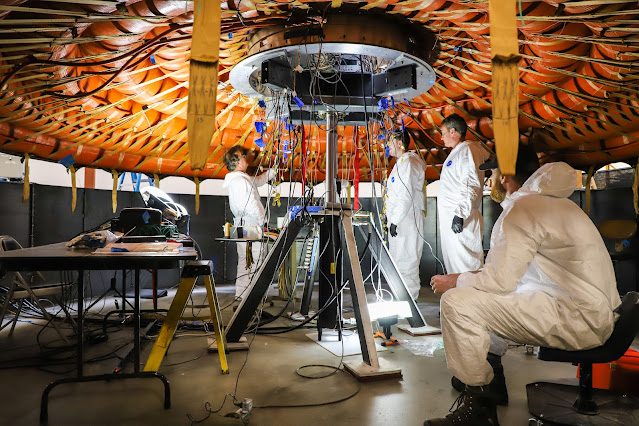
Image above: A teams works on NASA’s Low-Earth Orbit Flight Test of an Inflatable Decelerator (LOFTID), dedicated to the memory of Bernard Kutter, which will launch as a secondary payload aboard the Joint Polar Satellite System-2 (JPSS-2) mission. LOFTID is a demonstration of a hypersonic inflatable aerodynamic decelerator, or aeroshell, technology that could one day help land humans on Mars. Image Credit: NASA.

Launching as a secondary payload to JPSS-2 is NASA’s Low-Earth Orbit Flight Test of an Inflatable Decelerator (LOFTID), dedicated to the memory of Bernard Kutter. LOFTID is a demonstration of a hypersonic inflatable aerodynamic decelerator, or aeroshell, technology that could one day help land humans on Mars.

Inflatable Decelerator (LOFTID). Image Credit: NASA

Together, NOAA and NASA oversee the development, launch, testing, and operation of all the satellites in the JPSS program. NOAA funds and manages the program, operations, and data products. On behalf of NOAA, NASA develops and builds the instruments, spacecraft, and ground system, and launches the satellites, which NOAA operates.

The LOFTID project is sponsored by the Technology Demonstration Missions program within NASA’s Space Technology Mission Directorate in partnership with United Launch Alliance. LOFTID is managed by NASA’s Langley Research Center in Hampton, Virginia, with contributions from NASA’s Ames Research Center in California’s Silicon Valley, NASA’s Marshall Space Flight Center in Huntsville, Alabama, and NASA’s Armstrong Flight Research Center in Edwards, California.

Related links:

NASA’s Launch Services Program (LSP): https://www.nasa.gov/centers/kennedy/launchingrockets/index.html

Low-Earth Orbit Flight Test of an Inflatable Decelerator (LOFTID): https://www.nasa.gov/mission_pages/tdm/loftid/index.html

NASA’s Space Technology Mission Directorate: https://www.nasa.gov/directorates/spacetech/home/index.html

Joint Polar Satellite System-2 (JPSS-2): https://www.nesdis.noaa.gov/about/our-offices/joint-polar-satellite-system-jpss-program-office

NOAA: https://www.nasa.gov/subject/3649/noaa

Images (mentioned), Text, Credits: NASA/Linda Herridge.

Greetings, Orbiter.ch