samedi 17 octobre 2020

NASA InSight's 'Mole' Is Out of Sight


NASA - InSight Mission patch.


October 17, 2020

Now that the heat probe is just below the Martian surface, InSight's arm will scoop some additional soil on top to help it keep digging so it can take Mars' temperature.


Animation above: NASA's InSight retracted its robotic arm on Oct. 3, 2020, revealing where the spike-like "mole" is trying to burrow into Mars. The copper-colored ribbon attached to the mole has sensors to measure the planet's heat flow. In the coming months, the arm will scrape and tamp down soil on top of the mole to help it dig. Animation Credits: NASA/JPL-Caltech.

NASA's InSight lander continues working to get its "mole" - a 16-inch-long (40-centimeter-long) pile driver and heat probe - deep below the surface of Mars. A camera on InSight's arm recently took images of the now partially filled-in "mole hole," showing only the device's science tether protruding from the ground.

Sensors embedded in the tether are designed to measure heat flowing from the planet once the mole has dug at least 10 feet (3 meters) deep. The mission team has been working to help the mole burrow to at least that depth so that it can take Mars' temperature.

The mole was designed so that loose soil would flow around it, providing friction against its outer hull so that it can dig deeper; without this friction, the mole just bounces in place as it hammers into the ground. But the soil where InSight landed is different than what previous missions have encountered: During hammering, the soil sticks together, forming a small pit around the device instead of collapsing around it and providing the necessary friction.


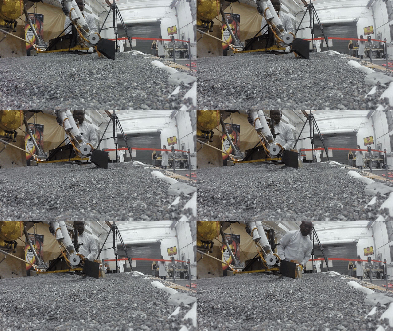
Animation above: This footage from Aug. 19, 2019, shows a replica of InSight scraping soil with a scoop on the end of its robotic arm in a test lab at JPL. A replica of the "mole" - the lander's self-hammering heat probe - comes in to view as the scoop moves to the left. On Mars, InSight will scrape and tamp down soil on top of the mole to help it dig. Animation Credits: NASA/JPL-Caltech.

After the mole unexpectedly backed out of the pit while hammering last year, the team placed the small scoop at the end of the lander's robotic arm on top of it to keep it in the ground. Now that the mole is fully embedded in the soil, they will use the scoop to scrape additional soil on top of it, tamping down this soil to help provide more friction. Because it will take months to pack down enough soil, the mole isn't expected to resume hammering until early 2021.

"I'm very glad we were able to recover from the unexpected 'pop-out' event we experienced and get the mole deeper than it's ever been," said Troy Hudson, the scientist and engineer at NASA's Jet Propulsion Laboratory who led the work to get the mole digging. "But we're not quite done. We want to make sure there's enough soil on top of the mole to enable it to dig on its own without any assistance from the arm."

The mole is formally called the Heat Flow and Physical Properties Package, or HP3, and was built and provided to NASA by the German Space Agency (DLR). JPL in Southern California leads the InSight mission. Read more about the mole's recent progress at this DLR blog.

More About the Mission

JPL manages InSight for NASA's Science Mission Directorate. InSight is part of NASA's Discovery Program, managed by the agency's Marshall Space Flight Center in Huntsville, Alabama. Lockheed Martin Space in Denver built the InSight spacecraft, including its cruise stage and lander, and supports spacecraft operations for the mission.


Image above: This illustration shows NASA's InSight spacecraft with its instruments deployed on the Martian surface. Image Credits: NASA/JPL-Caltech.

A number of European partners, including France's Centre National d'Études Spatiales (CNES) and the German Aerospace Center (DLR), are supporting the InSight mission. CNES provided the Seismic Experiment for Interior Structure (SEIS) instrument to NASA, with the principal investigator at IPGP (Institut de Physique du Globe de Paris). Significant contributions for SEIS came from IPGP; the Max Planck Institute for Solar System Research (MPS) in Germany; the Swiss Federal Institute of Technology (ETH Zurich) in Switzerland; Imperial College London and Oxford University in the United Kingdom; and JPL. DLR provided the Heat Flow and Physical Properties Package (HP3) instrument, with significant contributions from the Space Research Center (CBK) of the Polish Academy of Sciences and Astronika in Poland. Spain's Centro de Astrobiología (CAB) supplied the temperature and wind sensors.

Related links:

DLR blog: https://www.dlr.de/blogs/en/desktopdefault.aspx/tabid-5893/9577_read-1144/ressort-2/

Experiment for Interior Structure (SEIS): https://mars.nasa.gov/insight/mission/instruments/seis/

Heat Flow and Physical Properties Package (HP3): https://mars.nasa.gov/insight/mission/instruments/hp3/

InSight: https://www.nasa.gov/mission_pages/insight/main/index.html

Animations (mentioned), Image (mentioned), Text, Credits: NASA/Alana Johnson/Grey Hautaluoma/JPL/Andrew Good.

Greetings, Orbiter.ch

vendredi 16 octobre 2020

Space Science Picking Up Before Trio Departs for Earth


ISS - Expedition 64 Mission patch.


October 16, 2020

Science is doubling up on the International Space Station with the addition of three new space residents. However, they will split up on Oct. 21 before four more astronauts launch to join the Expedition 64 crew in November.

NASA astronaut Kate Rubins, on her second station mission, is stepping into her role as space scientist today while getting up to speed with life on orbit. She wore virtual reality goggles to explore how her sense of perception is adapting to microgravity. Rubins later serviced a biology research device that can produce up to 2g of artificial gravity.


Image above: Expedition 63 Flight Engineer Ivan Vagner transfers biological samples into a science freezer for stowage and later analysis aboard the International Space Station. Image Credit: NASA.

Rubins’ fellow crewmates Sergey Ryzhikov and Sergey Kud-Sverchkov will stay with her in space until April. Ryzhikov, on his second stay aboard the orbiting lab, unpacked cargo from the new Soyuz MS-17 crew ship today. First-time space-flyer Kud-Sverchkov checked out Russian science hardware.

Station Commander Chris Cassidy is nearing the end of his stay onboard the station with crewmates Anatoly Ivanishin and Ivan Vagner. The trio have been packing cargo and personal items inside the Soyuz MS-16 spacecraft that will parachute the crew back to Earth on Oct. 21. Cassidy will hand over command of the station to Ryzhikov on Oct. 20.

Soyuz MS spacecraft parachute the crew back to Earth. Animation Credits: ROSCOSMOS/NASA

All six station residents got together in the middle of the day and reviewed their emergency roles and responsibilities.

Meanwhile, four astronauts are planning to launch to the station aboard the SpaceX Crew Dragon vehicle. The company’s first operational crew mission is targeted to launch no sooner than early-to-mid November. Commander Mike Hopkins of NASA will lead Pilot Victor Glover and Mission Specialists Shannon Walker and Soichi Noguchi and stay in space until the Spring.

Related links:

Expedition 64: https://www.nasa.gov/mission_pages/station/expeditions/expedition64/index.html

Sense of perception: https://www.nasa.gov/mission_pages/station/research/experiments/explorer/Investigation.html?#id=7484

2g of artificial gravity: https://www.nasa.gov/mission_pages/station/research/experiments/explorer/Facility.html?#id=1777

Space Station Research and Technology: https://www.nasa.gov/mission_pages/station/research/overview.html

International Space Station (ISS): https://www.nasa.gov/mission_pages/station/main/index.html

Image (mentioned), Animation (mentioned), Text, Credits: NASA/Mark Garcia.

Best regards, Orbiter.ch

U.S.-European Sea Level Satellite Gears Up for Launch


ESA - Sentinel-6 Mission logo.


Oct. 16, 2020

The Sentinel-6 Michael Freilich spacecraft will soon be heading into orbit to monitor the height of the ocean for nearly the entire globe.


Animation above: This animation shows the radar pulse from the Sentinel-6 Michael Freilich satellite's altimeter bouncing off the sea surface in order to measure the height of the ocean. Animation Credits: NASA/JPL-Caltech.

Preparations are ramping up for the Nov. 10 launch of the world's latest sea level satellite. Since arriving in a giant cargo plane at Vandenberg Air Force Base in California last month, Sentinel-6 Michael Freilich has been undergoing final checks, including visual inspections, to make sure it's fit to head into orbit.

Surviving the bone-rattling vibrations and sounds of launch atop a Falcon 9 rocket is just the start of the mission. Once in orbit some 830 miles (1,336 kilometers) above Earth, Sentinel-6 Michael Freilich has the task of collecting sea level measurements with an accuracy of a few centimeters (for a single measurement) for more than 90% of the world's oceans. And it will be making those measurements while repeatedly flying through an area of intense radiation known as the South Atlantic Anomaly, which can scramble electronics.

That's why engineers and researchers have put Sentinel-6 Michael Freilich through a battery of tests to ensure that the spacecraft will survive launch and the harsh environment of space. But how will the mission pull the rest of it off? With sophisticated instruments, global navigation satellites, and lasers – lots of lasers. They'll all work in concert to enable the spacecraft to carry out its task of observing the ocean.

Given the challenges and goals of the mission, the satellite's moniker is appropriate: It's named after noted researcher Dr. Michael Freilich, the former director of NASA's Earth Science Division.

A second spacecraft identical to Sentinel-6 Michael Freilich, Sentinel-6B, will launch in 2025 to continue the work after its sibling's five-and-a-half-year prime mission ends. Together, the satellites make up the Sentinel-6/Jason-CS (Continuity of Service) mission, which is a partnership between NASA, ESA (the European Space Agency), the European Organisation for the Exploitation of Meteorological Satellites (EUMETSAT), and the National Oceanic and Atmospheric Administration (NOAA).

Collectively, the satellites will add a decade's worth of the most accurate satellite data yet on ocean height to a nearly 30-year record documenting how our oceans are rising in response to climate change. Both spacecraft will also collect data on atmospheric temperature and humidity that will help to improve weather forecasts as well as atmospheric and climate models.

This is where those sophisticated instruments, global navigation satellites, and lasers come in.


Image above: The Sentinel-6 Michael Freilich satellite undergoes final preparations in a clean room at Vandenberg Air Force Base in California for an early November launch. Image Credits: ESA/Bill Simpson.

How It Works

To accurately measure extremely small variations in sea level, Sentinel-6 Michael Freilich will rely on a suite of three instruments that provide scientists information to determine the spacecraft's exact position in orbit.

One component of this positioning package is the laser retroreflector array, a set of nine small, precisely shaped mirrors. Lasers are directed at them from ground stations on Earth, and they reflect the (harmless) beams right back to their point of origin. These laser-emitting ranging stations, as they're known, calculate how long the laser takes to bounce off the reflectors and return, which gives the distance between the satellite and the station.

Another instrument, the Global Navigation Satellite System – Precise Orbit Determination (GNSS-POD), tracks GPS and Galileo navigation signals. Researchers analyze these signals to help determine the satellite's position.

The third instrument in the positioning package is the Doppler Orbitography and Radioposition Integrated by Satellite (DORIS). It analyzes radio signals from 55 global ground stations, measuring the Doppler shift of the radio signals' frequencies to determine the 3D position of the satellite over time. When used together, these instruments provide the data needed to ascertain the precise position of the satellite, which in turn helps to determine the height of the sea surface.

On the science side are two instruments that work in concert to determine sea level and a third that collects atmospheric data. The Poseidon-4 radar altimeter measures ocean height by bouncing radar pulses off the water's surface and calculating the time it takes for the signal to return to the satellite. However, water vapor in the atmosphere affects the propagation of the radar pulses from the altimeter, which can make the ocean appear higher or lower than it actually is. To correct for this affect, an instrument called the Advanced Microwave Radiometer for Climate (AMR-C) measures the amount of water vapor between the spacecraft and the ocean.

"AMR-C is the next generation of AMR instruments, and it includes new components that will enable more accurate measurements along coastlines and throughout the mission," said Shannon Statham, AMR-C integration and test lead at NASA's Jet Propulsion Laboratory in Southern California.

Behind the Spacecraft – Sentinel-6 Michael Freilich – Sea Level Scout

Video above: Our planet is changing. Our ocean is rising. And it affects us all. That’s why a new international satellite will continue the decades-long watch over our global ocean and help us better understand how climate change is reshaping our planet.

For information on the atmosphere, the Global Navigation Satellite System – Radio Occultation (GNSS-RO) instrument gathers data on temperature and humidity that can help to improve weather forecasts. GNSS-RO analyzes radio signals from global navigational satellites as they appear and disappear beyond the limb of the Earth – the hazy blue edge of the atmosphere that's visible when you look at pictures of our planet in space. As these radio signals travel through different layers of the atmosphere, they bend and slow by varying degrees. Sentinel-6 Michael Freilich and satellites like it use GNSS-RO technology to measure these changes, enabling researchers to then extract atmospheric characteristics like temperature and humidity at different altitudes.

All the instruments, power systems, telecommunications – everything that makes Sentinel-6 Michael Freilich tick – must work together to accomplish the mission's science goals, much like the international partners have worked together to get this satellite ready for launch.

"Copernicus Sentinel-6 Michael Freilich is a great contribution to climate change, environment monitoring, and to the Digital Twin Earth. Sentinel-6 is a reference model of the cooperation between the U.S. and Europe on Earth Observation and represents a good foundation for future projects," said Josef Aschbacher, ESA director of Earth Observation Programmes.


Image above: In this illustration, the Sentinel-6 Michael Freilich spacecraft – the world's latest sea-level satellite – orbits Earth with its deployable solar panels extended. Image Credits: NASA/JPL-Caltech.

More About the Mission

Sentinel-6/Jason-CS is being jointly developed by ESA, EUMETSAT, NASA, and NOAA, with funding support from the European Commission and technical support from France's National Centre for Space Studies (CNES).

JPL, a division of Caltech in Pasadena, is contributing three science instruments for each Sentinel-6 satellite: the Advanced Microwave Radiometer, the Global Navigation Satellite System - Radio Occultation, and the Laser Retroreflector Array. NASA is also contributing launch services, ground systems supporting operation of the NASA science instruments, the science data processors for two of these instruments, and support for the international Ocean Surface Topography Science Team.

The Sentinel-6 Michael Freilich press kit:

https://www.jpl.nasa.gov/news/press_kits/sentinel-6/

To learn more about Sentinel-6 Michael Freilich, visit:

https://www.nasa.gov/sentinel-6

https://www.esa.int/Sentinel-6

https://www.copernicus.eu/en/documentation/information-material/general-factsheets

Images (mentioned), Animation (mentioned), Video (mentioned), Text, Credits: NASA/Naomi Hartono/JPL/Jane J. Lee/Ian J. O'Neill.

Greetings, Orbiter.ch

Ten Things to Know About Bennu


NASA - OSIRIS-REx Mission patch.


Oct. 16, 2020

NASA’s first mission to return a sample from an ancient asteroid arrived at its target, the asteroid Bennu, on Dec. 3, 2018. This mission, the Origins, Spectral Interpretation, Resource Identification, Security-Regolith Explorer, or OSIRIS-REx, is a seven-year long voyage set to conclude upon the delivery to Earth of at least 2.1 ounces (60 grams) and possibly up to almost four and a half pounds (two kilograms) of sample. It promises to be the largest amount of extraterrestrial material brought back from space since the Apollo era. The 20-year anniversary of the asteroid’s discovery was in September 2019 — and scientists have been collecting data ever since. Here’s what we already know (and some of what we hope to find out) about this pristine remnant from the early days of our solar system.

Tour of Asteroid Bennu

Video aobove: Now, thanks to laser altimetry data and high-resolution imagery from OSIRIS-REx, we can take a tour of Bennu’s remarkable terrain. Video Credits: NASA's Goddard Space Flight Center.

1. IT’S VERY, VERY DARK...

Bennu is classified as a B-type asteroid, which means it contains a lot of carbon in and along with its various minerals. Bennu’s carbon content creates a surface on the asteroid that reflects about four percent of the light that hits it — and that’s not a lot. For contrast, the solar system’s brightest planet, Venus, reflects around 65 percent of incoming sunlight, and Earth reflects about 30 percent. Bennu is a carbonaceous asteroid that hasn’t undergone drastic, composition-altering change, meaning that on and below its deeper-than-pitch-black surface are chemicals and rocks from the birth of the solar system.


Image above: This mosaic image of asteroid Bennu is composed of 12 PolyCam images collected on Dec. 2, 2018 by the OSIRIS-REx spacecraft from a range of 15 miles (24 km). Image Credits: NASA/Goddard/University of Arizona.

2. ...AND VERY, VERY OLD.

Bennu has been (mostly) undisturbed for billions of years. Not only is it conveniently close and carbonaceous, it is also so primitive that scientists calculated it formed in the first 10 million years of our solar system’s history — over 4.5 billion years ago. Thanks to the Yarkovsky effect -- the slight push created when the asteroid absorbs sunlight and re-emits that energy as heat -- and gravitational tugs from other celestial bodies, it has drifted closer and closer to Earth from its likely birthplace: the Main Asteroid Belt between Mars and Jupiter.

3. BENNU IS A “RUBBLE-PILE” ASTEROID — BUT DON’T LET THE NAME TRICK YOU.

Is Bennu space trash or scientific treasure? While “rubble pile” sounds like an insult, it’s actually a real astronomy classification. Rubble-pile asteroids like Bennu are celestial bodies made from lots of pieces of rocky debris that gravity compressed together. This kind of detritus is produced when an impact shatters a much larger body (for Bennu, it was a parent asteroid around 60 miles [about 100 km] wide). Bennu, for contrast, is about as tall as the Empire State Building. It likely took just a few weeks for these shards of space wreckage to coalesce into the rubble-pile that is Bennu. Bennu is full of holes inside, with 20 to 40 percent of its volume being empty space. The asteroid is actually in danger of flying apart, if it starts to rotate much faster or interacts too closely with a planetary body.

4. ASTEROIDS MAY HARBOR HINTS ABOUT THE ORIGIN OF ALL LIFE ON EARTH...

Bennu is a primordial artifact preserved in the vacuum of space, orbiting among planets and moons and asteroids and comets. Because it is so old, Bennu could be made of material containing molecules that were present when life first formed on Earth. All Earth life forms are based on chains of carbon atoms bonded with oxygen, hydrogen, nitrogen and other elements. However, organic material like the kind scientists hope to find in a sample from Bennu doesn’t necessarily always come from biology. It would, though, further scientists’ search to uncover the role asteroids rich in organics played in catalyzing life on Earth.

5. ...BUT ALSO PLATINUM AND GOLD!

Extraterrestrial jewelry sounds great, and Bennu is likely to be rich in platinum and gold compared to the average crust on Earth. Although most aren’t made almost entirely of solid metal (but asteroid 16 Psyche may be!), many asteroids do contain elements that could be used industrially in lieu of Earth’s finite resources. Closely studying this asteroid will give answers to questions about whether asteroid mining during deep-space exploration and travel is feasible. Although rare metals attract the most attention, water is likely to be the most important resource in Bennu. Water (two hydrogen atoms bound to an oxygen atom) can be used for drinking or separated into its components to get breathable air and rocket fuel. Given the high cost of transporting material into space, if astronauts can extract water from an asteroid for life support and fuel, the cosmic beyond is closer than ever to being human-accessible.

6. SUNLIGHT CAN CHANGE THE ASTEROID’S ENTIRE TRAJECTORY.

Gravity isn’t the only factor involved with Bennu’s destiny. The side of Bennu facing the Sun gets warmed by sunlight, but a day on Bennu lasts just 4 hours and 17.8 minutes, so the part of the surface that faces the Sun shifts constantly. As Bennu continues to rotate, it expels this heat, which gives the asteroid a tiny push towards the Sun by about 0.18 miles (approximately 0.29 kilometers) per year, changing its orbit.

OSIRIS-REx collecting sample. Animation Credit: NASA

7. THERE IS A SMALL CHANCE THAT BENNU WILL IMPACT EARTH LATE IN THE NEXT CENTURY.

The NASA-funded Lincoln Near-Earth Asteroid Research team discovered Bennu in 1999. NASA’s Planetary Defense Coordination Office continues to track near-Earth objects (NEOs), especially those like Bennu that will come within about 4.6 million miles (7.5 million kilometers) of Earth’s orbit and are classified as potentially hazardous objects. Between the years 2175 and 2199, the chance that Bennu will impact Earth is only 1-in-2,700, but scientists still don’t want to turn their backs on the asteroid. Bennu swoops through the solar system on a path that scientists have confidently predicted, but they will refine their predictions with the measurement of the Yarkovsky Effect by OSIRIS-REx and with future observations by astronomers.

8. SAMPLING BENNU WILL BE HARDER THAN WE THOUGHT.

Early Earth-based observations of the asteroid suggested it had a smooth surface with a regolith (the top layer of loose, unconsolidated material) composed of particles less than an inch (a couple of centimeters) large — at most. As the OSIRIS-REx spacecraft was able to take pictures with higher resolution, it became evident that sampling Bennu would be far more hazardous than what was previously believed: new imagery of Bennu’s surface show that it’s mostly covered in massive boulders, not small rocks. OSIRIS-REx was designed to be navigated within an area on Bennu of nearly 2,000 square yards (meters), roughly the size of a parking lot with 100 spaces. Now, it must maneuver to a safe spot on Bennu’s rocky surface within a constraint of less than 100 square yards, an area of about five parking spaces.


Animation above: Captured on Aug. 11, 2020 during the second rehearsal of the OSIRIS-REx mission’s sample collection event, this series of images shows the SamCam imager’s field of view as the NASA spacecraft approaches asteroid Bennu’s surface. The rehearsal brought the spacecraft through the first three maneuvers of the sampling sequence to a point approximately 131 feet (40 meters) above the surface, after which the spacecraft performed a back-away burn. Animation Credits: NASA/Goddard/University of Arizona.

9. BENNU WAS NAMED AFTER AN ANCIENT EGYPTIAN DEITY.

Bennu was named in 2013 by a nine-year-old boy from North Carolina who won the Name that Asteroid! competition, a collaboration between the mission, the Planetary Society, and the LINEAR asteroid survey that discovered Bennu. Michael Puzio won the contest by suggesting that the spacecraft’s Touch-and-Go Sample Mechanism (TAGSAM) arm and solar panels resemble the neck and wings in illustrations of Bennu, whom ancient Egyptians usually depicted as a gray heron. Bennu is the ancient Egyptian deity linked with the Sun, creation and rebirth — Puzio also noted that Bennu is the living symbol of Osiris. The myth of Bennu suits the asteroid itself, given that it is a primitive object that dates back to the creation of the Solar System. Themes of origins and rebirth are part of this asteroid’s story. Birds and bird-like creatures are also symbolic of rebirth, creation and origins in various ancient myths.

10. BENNU IS STILL SURPRISING US!

The spacecraft’s navigation camera observed that Bennu was spewing out streams of particles a couple of times each week. Bennu apparently is not only a rare active asteroid (only a handful of them have been as of yet identified), but possibly with Ceres explored by NASA’s Dawn mission, among the first of its kind that humanity has observed from a spacecraft. More recently, the mission team discovered that sunlight can crack rocks on Bennu, and that it has pieces of another asteroid scattered across its surface. More pieces will be added to Bennu’s cosmic puzzle as the mission progresses, and each brings the solar system’s evolutionary history into sharper and sharper focus.


Image above: This view of asteroid Bennu ejecting particles from its surface on January 19, 2019 was created by combining two images taken on board NASA’s OSIRIS-REx spacecraft. Other image processing techniques were also applied, such as cropping and adjusting the brightness and contrast of each image. Image Credits: NASA/Goddard/University of Arizona/Lockheed Martin.

Goddard provides overall mission management, systems engineering, and the safety and mission assurance for OSIRIS-REx. Dante Lauretta of the University of Arizona, Tucson, is the principal investigator, and the University of Arizona also leads the science team and the mission’s science observation planning and data processing. Lockheed Martin Space in Denver built the spacecraft and is providing flight operations. Goddard and KinetX Aerospace are responsible for navigating the OSIRIS-REx spacecraft. OSIRIS-REx is the third mission in NASA’s New Frontiers Program, which is managed by NASA’s Marshall Space Flight Center in Huntsville, Alabama, for the agency’s Science Mission Directorate in Washington.

For more information about NASA's OSIRIS-REx mission, visit:

OSIRIS-REx (Origins Spectral Interpretation Resource Identification Security Regolith Explorer): http://www.nasa.gov/mission_pages/osiris-rex/index.html

Images (mentioned), Animations (mentioned), Text, Credits: NASA/GSFC/Bill Steigerwald/Nancy Jones/By Tamsyn Brann.

Best regards, Orbiter.ch

Space Station Science Highlights: Week of October 12, 2020


ISS - Expedition 63 Mission patch.


Oct. 16, 2020

Crew members aboard the International Space Station conducted studies of muscle loss, fungi and bacteria in soil, and boiling phenomena during the week of Oct. 12. NASA astronaut Kate Rubins and Roscosmos cosmonauts Sergey Ryzhikov and Sergey Kud-Sverchkov arrived at the space station early on Wednesday, Oct.14. NASA astronaut Chris Cassidy and cosmonauts Anatoly Ivanishin and Ivan Vagner began packing for their return to Earth, currently scheduled for Oct. 21. Their departure marks the beginning of Expedition 64.


Image above: The Soyuz spacecraft is shown docked to the space station Wednesday morning. The hatches officially opened at 7:07 a.m. EDT for the three new crew members to enter the orbiting lab, restoring the crew complement to six for the remainder of Expedition 63. Image Credit: NASA.

Now in its 20th year of continuous human presence, the space station provides a platform for long-duration research in microgravity and for learning to live and work in space. Experience gained on the orbiting lab supports Artemis, NASA’s program to go forward to the Moon and on to Mars.

Here are details on some of the microgravity investigations currently taking place:

Observing muscle properties


Image above: A bubble generated during operations of Multiscale Boiling. This investigation from the ESA (European Space Agency) tests fundamentals of boiling such as the onset of bubbles, which behave differently in microgravity than on Earth. Image Credits: Institute of Technical Thermodynamics, Darmstadt, Germany.

The crew completed blood collection and processing as well as scans of specific muscle targets for the Muscle Tone in Space (Myotones), an ESA (European Space Agency) investigation, during the week. This observation of the biochemical properties of muscles during long-term exposure to spaceflight is expected to provide insight into principles of human resting muscle tone. Results could lead to the development of new strategies for alternative treatments to combat muscle loss during future space missions and from disease and disuse on Earth.

Healthier soil for better food production


Image above: This image shows the Tangolab CubeLab for Pharmaceutical Excipient Ingredient Stability in Microgravity, an investigation by the University of Adelaide that tests long-duration stability of medicines in space. Researchers hope to develop spacelabs for on-orbit formulation and manufacturing of pharmaceuticals. Image Credit: NASA.

The rhizosphere, or layer of soil that interacts with plant roots, contains clumps of soil particles called aggregates. Formed by fungi and bacteria, these aggregates provide the nutrients plants need to grow. Recent studies have shown a connection between biological activity, aggregation formation, and the overall capacity of soils to sustainably produce nutritious food crops. Soil Health in Space: Determination of Gravitational Effects on Soil Stability for Controlled Environment Agriculture (Rhodium Space Rhizosphere) examines how spaceflight affects soil aggregates in order to help improve food production in space and on Earth. The crew prepared sample chambers for the investigation during this week.

A better look at boiling

Boiling is a common but complex phenomenon important to many applications, including energy conversion, food and chemical processes, fuel storage and propulsion, and electronics cooling. Multiscale Boiling, an investigation from the ESA (European Space Agency), tests fundamentals of boiling such as the onset of bubbles and transfer of heat. Conducting the experiments in microgravity makes it possible to observe effects that are too fast and too small to be measured under normal gravity conditions. A better understanding of the dynamics of boiling could improve the design of future space applications such as fuel storage, propulsion, and cooling of electronic devices. During the week, crew members set up the Multi-Scale Boiling Experiment Container in the ESA Fluid Science Laboratory (FSL), a multiuser facility designed for conducting fluid physics research in microgravity

Other investigations on which the crew performed work:

- Evaluation of Long-Term Stability of Pharmaceutical Ingredients in an Excipient Matrix for Use in Potential Future On-Orbit Manufacturing (Pharmaceutical Excipient Ingredient Stability in Microgravity) evaluates the effects of microgravity and radiation on the long-term stability of non-active ingredients of medicines. Results could support development of the capability to formulate medicines in space.
https://www.nasa.gov/mission_pages/station/research/experiments/explorer/Investigation.html?#id=8307

- The Effect of Long Duration Hypogravity on the Perception of Self-Motion (VECTION), a Canadian Space Agency investigation, determines to what extent microgravity disrupts an astronaut's ability to visually interpret motion, orientation, and distance as well as how those abilities may adapt in space and change again upon return to Earth.
https://www.nasa.gov/mission_pages/station/research/experiments/explorer/Investigation.html?#id=7484

- The Whole Genome Fitness of Bacteria under Microgravity (Bacterial Genome Fitness) investigation looks at what environmental factors and processes are important for bacteria to grow in space. Results could help spacecraft designers control or prevent bacterial growth.
https://www.nasa.gov/mission_pages/station/research/experiments/explorer/Investigation.html?#id=8020

- Actiwatch is a monitor worn by a crew member that continuously collects data on circadian rhythms, sleep-wake patterns, and activity during flight, beginning as soon as possible after arrival aboard the station.
https://www.nasa.gov/mission_pages/station/research/experiments/explorer/Facility.html?#id=838

- Leveraging Microgravity to Screen Onco-selective Messenger RNAs for Cancer Immunotherapy (Onco-Selectors) tests drugs based on messenger ribonucleic acids (mRNA) to treat leukemia.
https://www.nasa.gov/mission_pages/station/research/experiments/explorer/Investigation.html?#id=8265

- The Integrated Impact of Diet on Human Immune Response, the Gut Microbiota, and Nutritional Status During Adaptation to Spaceflight (Food Physiology) investigation documents the effects of dietary improvements on immune function and the gut microbiome and the ability of those improvements to support adaptation to spaceflight.
https://www.nasa.gov/mission_pages/station/research/experiments/explorer/Investigation.html?#id=7870

- ISS Ham Radio gives students an opportunity to talk directly with crew members via ham radio, engaging and educating students, teachers, parents, and other members of the community in science, technology, engineering, and math.
https://www.nasa.gov/mission_pages/station/research/experiments/explorer/Investigation.html?#id=337 

Space to Ground: Fresh Dining: 10/16/2020

Related links:

Expedition 63: https://www.nasa.gov/mission_pages/station/expeditions/expedition63/index.html

Myotones: https://www.nasa.gov/mission_pages/station/research/experiments/explorer/Investigation.html?#id=7573

Rhodium Space Rhizosphere: https://www.nasa.gov/mission_pages/station/research/experiments/explorer/Investigation.html?#id=8305

Multiscale Boiling: https://www.nasa.gov/mission_pages/station/research/experiments/explorer/Investigation.html?#id=8224

Fluid Science Laboratory (FSL): https://www.nasa.gov/mission_pages/station/research/experiments/explorer/Facility.html?#id=258

ISS National Lab: https://www.issnationallab.org/

Spot the Station: https://spotthestation.nasa.gov/

Space Station Research and Technology: https://www.nasa.gov/mission_pages/station/research/overview.html

International Space Station (ISS): https://www.nasa.gov/mission_pages/station/main/index.html

Images (mentioned), Video (NASA), Text, Credits: NASA/Michael Johnson/John Love, ISS Research Planning Integration Scientist Expedition 63.

Best regards, Orbiter.ch

Hubble Snaps a Special Stellar Nursery


ESA & NASA - Hubble Space Telescope (HST) patch.


Oct. 16, 2020


This image, taken with the NASA/ESA Hubble Space Telescope, depicts a special class of star-forming nursery known as Free-floating Evaporating Gaseous Globules, or frEGGs for short. This object is formally known as J025157.5+600606.

When a massive new star starts to shine while still within the cool molecular gas cloud from which it formed, its energetic radiation can ionize the cloud’s hydrogen and create a large, hot bubble of ionized gas. Amazingly, located within this bubble of hot gas around a nearby massive star are the frEGGs: dark compact globules of dust and gas, some of which are giving birth to low-mass stars. The boundary between the cool, dusty frEGG and the hot gas bubble is seen as the glowing purple/blue edges in this fascinating image.

Hubble Space Telescope (HST)

For more information about Hubble, visit:

http://hubblesite.org/

http://www.nasa.gov/hubble

http://www.spacetelescope.org/

Text Credits: ESA (European Space Agency)/NASA/Rob Garner/Image, Animation Credits: ESA/Hubble & NASA, R. Sahai.

Greetings, Orbiter.ch

Cliffs in Ancient Ice on Mars


NASA - Mars Reconnaissance Orbiter (MRO) patch.


Oct. 16, 2020

Scientists have come to realize that, just below the surface, about one third of Mars is covered in ice. We study this ice to learn about Mars' ancient climate and astronauts' future water supplies.


Sometimes we see the buried ice because cliffs form like the one in this image. On the brownish, dusty cliff wall, the faint light-blue-colored ice shows through. Some of these cliffs change before our eyes and boulders of ice can tumble downhill. We take repeat images of these scenes to check for changes like this.

For additional information about Mars Reconnaissance Orbiter (MRO), visit: http://www.nasa.gov/mission_pages/MRO/main/index.html

Images, Text Credits: NASA/Yvette Smith/JPL-Caltech/University of Arizona.

Greetings, Orbiter.ch

jeudi 15 octobre 2020

New Space Residents Adjust to Life on Station


ISS - Expedition 63 Mission patch.


October 15, 2020

International Space Station (ISS). Animation Credit: NASA

Six International Space Station residents will spend a week working together in low-Earth orbit before splitting up on Oct. 21. As the new Expedition 64 trio gets used to life in space, four more astronauts are planning to join them in November.

Three new station crew members are adapting to living and working in space after a short trip to the orbiting lab in their Soyuz MS-17 crew ship on Wednesday. NASA astronaut Kate Rubins and Roscosmos cosmonaut Sergey Ryzhikov are each beginning their second mission in microgravity. The experienced pair, including fellow crewmate and new space-flyer Sergey Kud-Sverchkov from Roscosmos, will conduct their space research mission until April of next year.


Image above: The Soyuz MS-17 spacecraft, with the Expedition 64 crew inside, approaches the space station for a docking on Oct. 14. Image Credit: NASA.

Meanwhile, Rubins got right to work today and assisted station Commander Chris Cassidy servicing hardware inside the Japanese Kibo laboratory module. Ryzhikov and Kud-Sverchkov unpacked gear from their Soyuz spacecraft. The Russian duo also joined Expedition 63 Flight Engineer Ivan Vagner for handover activities to get up to speed with lab systems.

Cassidy and Vagner are also getting ready to return to Earth on Oct. 21 with Soyuz Commander Anatoly Ivanishin. The trio has begun packing station gear and personal items inside their Soyuz MS-16 spacecraft. They are also in the process of handing over station responsibilities to the new Expedition 64 trio.


Image above: The Soyuz MS-15 spacecraft is seen as it lands in a remote area near the town of Zhezkazgan, Kazakhstan with Expedition 62 crew members Jessica Meir and Drew Morgan of NASA, and Oleg Skripochka of Roscosmos, Friday, April 17, 2020. Meir and Skripochka returned after 205 days in space, and Morgan after 272 days in space. All three served as Expedition 60-61-62 crew members onboard the International Space Station. Image Credits: NASA/GCTC/Andrey Shelepin.

Back on Earth, four astronauts are getting ready to launch to the station aboard the SpaceX Crew Dragon vehicle for the company’s first operational crew mission targeted to launch no sooner than early-to-mid November. Commander Mike Hopkins of NASA will lead Pilot Victor Glover and Mission Specialists Shannon Walker and Soichi Noguchi and stay in space until the Spring.

Related article:

Landing Coverage Set for NASA Astronaut Chris Cassidy, Space Station Crew
https://www.nasa.gov/press-release/landing-coverage-set-for-nasa-astronaut-chris-cassidy-space-station-crew

Related links:

Expedition 63: https://www.nasa.gov/mission_pages/station/expeditions/expedition63/index.html

Expedition 64: https://www.nasa.gov/mission_pages/station/expeditions/expedition64/index.html

Kibo laboratory module: https://www.nasa.gov/mission_pages/station/structure/elements/japan-kibo-laboratory

Space Station Research and Technology: https://www.nasa.gov/mission_pages/station/research/overview.html

International Space Station (ISS): https://www.nasa.gov/mission_pages/station/main/index.html

Animation (mentioned), Images (mentioned), Text, Credits: NASA/Mark Garcia.

Best regards, Orbiter.ch

Prior Weather Linked to Rapid Intensification of Hurricanes Near Landfall


NASA logo.


Oct. 15, 2020

New study results show that ocean heat waves can provide enough fuel for hurricanes to gain momentum as they approach land.


Image above: Hurricane Michael was captured from the International Space Station on Oct. 10, 2018, after the storm made landfall as a Category 4 hurricane over the Florida Panhandle. The National Hurricane Center reported maximum sustained winds near 145 mph (233 kph) with the potential to bring dangerous storm surge and heavy rains to the Florida Panhandle. Image Credit: NASA.

Although most hurricanes tend to weaken as they approach land, some rapidly increase in strength just prior to landfall – a phenomenon that is both dangerous and hard to forecast. As the climate continues to warm, the number of storms that fall into the latter category is likely to increase, presenting a stark reality for communities in their paths. Because current weather models can't accurately predict this sudden intensification, communities preparing for a lesser storm often don't have time to respond to the arrival of a much stronger one or to the magnitude of destruction it is likely to leave behind.


Image above: This map of the Gulf of Mexico shows areas with unusually high sea surface temperatures before Hurricane Michael. The area from land down to the green line, and the small, enclosed areas below the green line experienced an extreme ocean heat wave in this period. The smaller circles show the path of Tropical Storm Gordon (TS), which preceded Michael; larger, darker circles show Michael's track and intensification. The legend's first four icons mark data stations. Image Credits: NASA/JPL-Caltech/University of South Alabama/DISL.

The good news? The results of a new study published in September in Nature Communications identify pre-storm conditions that can contribute to this rapid intensification – an important step in improving our ability to forecast it.

"We analyzed the events that led up to Hurricane Michael in 2018 and found that the storm was preceded by a marine heat wave, an area of the coastal ocean water that had become abnormally warm," said Severine Fournier, a NASA Jet Propulsion Laboratory scientist and a co-author of the study. "Marine heat waves like this one can form in areas that have experienced back-to-back severe weather events in a short period of time."


Image above: NOAA's GOES-East satellite captured this image of Hurricane Michael as it came ashore near Mexico Beach, Florida, on Oct. 10, 2018. Image Credit: NOAA.

In October 2018, Hurricane Michael intensified from a Category 2 to a Category 5 storm the day before it made landfall in the Florida Panhandle. Michael is the most intense storm on record to hit the area, having left some $25 billion in damage in its wake. Using a combination of data gathered from weather buoys and satellites, the science team behind the study examined ocean conditions before, during, and after the hurricane.

About a month before the hurricane arrived, Tropical Storm Gordon moved through the Gulf of Mexico. Under normal circumstances, a tropical storm or hurricane – Gordon, in this case – mixes the ocean water over which it travels, bringing up the cold water that is deeper in the water column to the surface and pushing the warm surface water down toward the bottom. This newly present colder water at the surface typically causes the storm to weaken.

But Tropical Storm Gordon was immediately followed by a severe atmospheric heat wave during which the warm air heated the cooler ocean water that had recently been brought to the surface. This, combined with the warm water that Gordon had pushed down through the water column, ultimately produced plenty of warm-water fuel for an incoming hurricane.

"In that situation, basically the whole water column was made up of warm water," said Fournier. "So when the second storm – Hurricane Michael – moved in, the water it brought up during mixing was warm just like the surface water being pushed down. Hurricanes feed off the heat of the ocean, so this sequence of weather events created conditions that were ideal for hurricane intensification."

Although the study focuses in-depth on Hurricane Michael, the scientists note that the pattern of weather events leading up to a major storm – and the resulting storm intensification – doesn't appear to be unique to Michael.


Image above: A buoy marks the West End CP mooring site south of Dauphin Island, Alabama, in the Gulf of Mexico. It is one of many stations that collect data on ocean conditions like temperature and salinity. Image Credits: University of South Alabama/DISL.

"Both Hurricane Laura and Hurricane Sally, which impacted the U.S. Gulf Coast in 2020, appeared to have similar setups to Michael, with both storms being preceded by smaller storms [Hurricane Hanna and Hurricane Marco, respectively]," said lead author Brian Dzwonkowski of the University of South Alabama/Dauphin Island Sea Lab. "Combined with warmer-than-average summer conditions in the region, this pre-storm setup of the oceanic environment likely contributed to those intensifications prior to landfall as well."

NASA scientists have been tackling the question of what causes hurricanes to intensify rapidly just before landfall from multiple angles. Another recent study led by JPL's Hui Su found that other factors, including the rainfall rate inside a hurricane, are also good indicators that can help forecast if and how much a hurricane is likely to intensify in the hours that follow. Both studies bring us closer to understanding and being better able to forecast rapid intensification of hurricanes near landfall.

Related links:

Hurricanes: http://www.nasa.gov/mission_pages/hurricanes/main/index.html

Jet Propulsion Laboratory (JPL): https://www.nasa.gov/centers/jpl/home/index.html

Images (mentioned), Text, Credits: NASA/Tony Greicius/JPL/Ian J. O'Neill/Jane J. Lee/Written by Esprit Smith, NASA's Earth Science News Team.

Greetings, Orbiter.ch

BepiColombo flies by Venus en route to Mercury


ESA & JAXA - BepiColombo Mission patch.


Oct. 15, 2020

The ESA-JAXA BepiColombo mission has completed the first of two Venus flybys needed to set it on course with the Solar System’s innermost planet, Mercury.

The closest approach of the flyby took place at 03:58 GMT (05:58 CEST) this morning at a distance of about 10 720 km from the planet’s surface.

Launched 20 October 2018, the spacecraft needs nine gravity assist flybys – one at Earth, two at Venus and six at Mercury before entering orbit around the planet in 2025. Flybys ultilise the gravitational pull of the planets to help alter the speed and direction of the spacecraft, and together with the spacecraft’s solar electric propulsion system, help BepiColombo steer into Mercury orbit against the strong gravitational pull of the Sun.

The first flyby – of Earth – took place 10 April this year, returning poignant images of our home planet as the world faced lockdown due to the COVID-19 pandemic.

Flying by teleworking


 BepiColombo images Venus during close approach

“For the Venus flyby we conducted the large majority of our preparations over the last three months via teleworking, with only the minimum personnel required onsite during the flyby to ensure the safe operation of the spacecraft,” says Elsa Montagnon, ESA’s BepiColombo Spacecraft Operations Manager.

The on-site team at ESA’s mission control centre in Darmstadt, Germany, comprised four members of the flight control team split into two groups over a period of 36 hours, together with a ground station manager, and two team members joining around closest approach to manage the images as they were downloaded from the spacecraft. 

Image above: This sequence of 64 images was captured by the Monitoring Camera 3 onboard the Mercury Transfer Module between 06:58 UTC and 13:57 UTC on 14 October 2020, corresponding to a distance of approximately 600 000 km to 400 000 km from Venus. One image was taken approximately every three minutes. At first, Venus is seen clearly moving across the field of view close to the spacecraft body on the left, because the spacecraft is slewing to point to Venus. Then, Venus gets progressively bigger in the field of view, as the spacecraft approaches. The shadow moving across the spacecraft is cast by the Mercury Transfer Module solar array.

“The flyby itself was very successful,” confirms Elsa. “The only difference to normal cruise phase operations is that near to Venus we have to temporarily close the shutter of any of the star trackers that are expected to be blinded by the planet, similar to closing your eyes to avoid looking at the Sun.”

Two of the three monitoring cameras onboard the Mercury Transfer Module were activated during dedicated imaging slots from 20 hours before closest approach through to 15 minutes afterwards. From afar, Venus is seen as a small disc in the camera’s field of view, close to the spacecraft body. During the closest approach phase the planet dominates the view, 'rising' behind the magnetometer boom of the Mercury Planetary Orbiter.

BepiColombo’s first Venus flyby

Science in the making

Seven of the eleven science instruments onboard the European Mercury Planetary Orbiter, plus its radiation monitor, and three of five onboard the Japanese Mercury Magnetospheric Orbiter were active during the flyby. While the suite of sensors are designed to study the rocky, atmosphere-free environment at Mercury, the flyby offered a unique opportunity to collect valuable science data at Venus.

“Following the successful Earth flyby where our instruments worked even better than expected, we are looking forward to see what will come out of the Venus flyby,” says Johannes Benkhoff, ESA’s BepiColombo Project Scientist.

Venus setting

“We’ll have to be patient while our Venus specialists look carefully into the data, but we hope to be able to provide some atmosphere temperature and density profiles, information about the chemical composition and cloud cover, and on the magnetic environment interaction between the Sun and Venus. But we rather anticipate more results next year than now, given the closer flyby distance, so watch this space!”

The 2021 flyby, planned for 10 August, will see the spacecraft pass within just 550 km of the planet’s surface.

Telescope teamwork

BepiColombo’s first glimpse of Venus

Today’s encounter also provided the chance to make simultaneous measurements with JAXA’s Akatsuki Venus Climate Orbiter and its Earth-orbiting Hisaki Spectroscopic Planet Observatory, together with ground-based observatories to study Venus from multiple viewpoints and at different scales.

“Akatsuki is currently the only spacecraft in orbit around Venus and because of its elliptical orbit it was actually 30 times further away from the planet than BepiColombo during the flyby, meaning we can compare close observations of BepiColombo with Akatsuki’s global-scale view,” says Go Murakami, JAXA’s BepiColombo Project Scientist.

“A large campaign of coordinated observations are ongoing, involving professional and amateur astronomers alike, that will build a three-dimensional picture of what’s happening over time in Venus’ atmosphere, something that cannot be achieved by one spacecraft or one telescope alone," says Valeria Mangano, of the National Institute for Astrophysics in Italy, and chair of the Venus flyby working group.

BepiColombo’s first Venus flyby

Next steps

While the science teams are busy diving into the new flyby data, the operations teams will assess the performance of the Venus flyby and make a routine trajectory correction of the spacecraft on 22 October. The next dedicated solar electric propulsion arc is planned for May 2021.

BepiColombo will also make its first Mercury flyby next year, in October, at a distance of just 200 km, providing the first tantalizing taste of what will follow once the mission’s two science orbiters have arrived in their dedicated orbits around the planet. There they will study Mercury’s mysteries, addressing numerous open questions in planetary science, such as: where in the Solar System did Mercury form? What is the nature of the ice in Mercury’s shadowed craters? Is the planet still geologically active? How can such a small planet still have a magnetic field?

“With each flyby completed we get a step closer to answering some of these perplexing questions about mysterious planet Mercury,” adds Johannes. “Learning more about Mercury will shed light on the history of the entire Solar System, helping us to better understand our own place in space.”

"While gravity assists have a practical function to set us on course for Mercury, it is wonderful to have these brief opportunities to observe Venus as we fly through the Solar System," says Simon Plum, ESA's Head of Mission Operations.
"Thanks to the teams who have been working hard behind the scenes over the last months to make this flyby a success. While we work with incredibly far distances and a tremendous amount of space as we navigate the Solar System, we are again dealing with special operations under pandemic situation, where space between our people matter and the safety of our colleagues remain the number one priority.”

About BepiColombo

BepiColombo is Europe's first mission to Mercury. Launched on 20 October 2018, it is on a seven-year journey to the smallest and least explored terrestrial planet in our Solar System. The mission is a joint endeavour between ESA and the Japan Aerospace Exploration Agency (JAXA), carried out under ESA leadership.

BepiColombo comprises two scientific orbiters: ESA’s Mercury Planetary Orbiter (MPO) and JAXA’s Mercury Magnetospheric Orbiter (Mio). The European Mercury Transfer Module (MTM) carries the orbiters to Mercury. After arrival at Mercury in late 2025, the spacecraft will separate and the two orbiters will manoeuvre to their dedicated polar orbits around the planet. Starting science operations in early 2026, both orbiters will gather data during a one-year nominal mission, with a possible one-year extension.

The mission is named after the Italian mathematician and engineer Giuseppe (Bepi) Colombo (1920–84).

Follow the mission via https://www.esa.int/BepiColombo/

The JAXA mission website is available in English here: http://mio.isas.jaxa.jp/en/

Images, Animation, Video, Text, Credits: ESA/BepiColombo/MTM, CC BY-SA 3.0 IGO.

Best regards, Orbiter.ch

mercredi 14 octobre 2020

Earth and Moon Once Shared a Magnetic Shield, Protecting Their Atmospheres


NASA - ARTEMIS Program logo.


Oct. 14, 2020

Four-and-a-half billion years ago, Earth’s surface was a menacing, hot mess. Long before the emergence of life, temperatures were scorching, and the air was toxic. Plus, as a mere toddler, the Sun bombarded our planet with violent outbursts of radiation called flares and coronal mass ejections. Streams of charged particles called the solar wind threatened our atmosphere. Our planet was, in short, uninhabitable.


Image above: The Earth and Moon, shown here in a composite of two images from the Galileo mission of the 1990s, have a long shared history. Billions of years ago, they had connected magnetic fields. Image Credits: NASA/JPL/USGS.

But a neighboring shield may have helped our planet retain its atmosphere and eventually go on to develop life and habitable conditions. That shield was the Moon, says a NASA-led study in the journal Science Advances.

“The Moon seems to have presented a substantial protective barrier against the solar wind for the Earth, which was critical to Earth’s ability to maintain its atmosphere during this time,” said Jim Green, NASA’s chief scientist and lead author of the new study. “We look forward to following up on these findings when NASA sends astronauts to the Moon through the Artemis program, which will return critical samples of the lunar South Pole.”


Image above: This illustration shows magnetic field lines that Earth generates today. The Moon no longer has a magnetic field. Image Credit: NASA.

A brief history of the Moon

The Moon formed 4.5 billion years ago when a Mars-sized object called Theia slammed into the proto-Earth when our planet was less than 100 million years old, according to leading theories. Debris from the collision coalesced into the Moon, while other remnants reincorporated themselves into the Earth. Because of gravity, the presence of the Moon stabilized the Earth’s spin axis. At that time, our planet was spinning much faster, with one day lasting only 5 hours.

And in the early days, the Moon was a lot closer, too. As the Moon’s gravity pulls on our oceans, the water is slightly heated, and that energy gets dissipated. This results in the Moon moving away from Earth at a rate of 1.5 inches per year, or about the width of two adjacent dimes. Over time, that really adds up. By 4 billion years ago, the Moon was three times closer to Earth than it is today – about 80,000 miles away, compared to the current 238,000 miles. At some point, the Moon also became “tidally locked,” meaning Earth sees only one side of it.

Scientists once thought that the Moon never had a long-lasting global magnetic field because it has such a small core. A magnetic field causes electrical charges to move along invisible lines, which bow down toward the Moon at the poles. Scientists have long known about Earth’s magnetic field, which creates the beautifully colored aurorae in the Arctic and Antarctic regions.


Image above: When the Moon had a magnetic field, it would have been shielded from incoming solar wind, as shown in this illustration. Image Credit: NASA.

A magnetic field serves as a shield causing electrical charges to move along its invisible lines. Scientists have long known about Earth’s magnetic field, which causes the beautifully colored aurorae in the Arctic and Antarctic regions. The movement of liquid iron and nickel deep inside the Earth, still flowing because of the heat left over from Earth’s formation, generates the magnetic fields that make up a protective bubble surrounding Earth, the magnetosphere.

But thanks to studies of samples of the lunar surface from the Apollo missions, scientists figured out that the Moon once had a magnetosphere, too. Evidence continues to mount from samples that were sealed for decades and recently analyzed with modern technology.

Like Earth, the heat from the Moon’s formation would have kept iron flowing deep inside, although not for nearly as long because of its size.

“It’s like baking a cake: You take it out of the oven, and it’s still cooling off,” Green said. “The bigger the mass, the longer it takes to cool off.”

A magnetic shield

The new study simulates how the magnetic fields of the Earth and Moon behaved about 4 billion years ago. Scientists created a computer model to look at the behavior of the magnetic fields at two positions in their respective orbits.

At certain times, the Moon’s magnetosphere would have served as a barrier to the harsh solar radiation raining down on the Earth-Moon system, scientists write. That’s because, according to the model, the magnetospheres of the Moon and Earth would have been magnetically connected in the polar regions of each object. Importantly for the evolution of Earth, the high-energy solar wind particles could not completely penetrate the coupled magnetic field and strip away the atmosphere.

But there was some atmospheric exchange, too. The extreme ultraviolet light from the Sun would have stripped electrons from neutral particles in Earth’s uppermost atmosphere, making those particles charged and enabling them to travel to the Moon along the lunar magnetic field lines. This may have contributed to the Moon maintaining a thin atmosphere at that time, too. The discovery of nitrogen in lunar rock samples support the idea that Earth’s atmosphere, which is dominated by nitrogen, contributed to the Moon’s ancient atmosphere and its crust.


Image above: This illustration shows how Earth and its Moon both had magnetic fields that were connected billions of years ago, helping to protect their atmospheres from streams of damaging solar particles, according to new research. Image Credit: NASA.

Scientists calculate that this shared magnetic field situation, with Earth and Moon’s magnetospheres joined, could have persisted from 4.1 to 3.5 billion years ago.

“Understanding the history of the Moon's magnetic field helps us understand not only possible early atmospheres, but how the lunar interior evolved,” said David Draper, NASA’s deputy chief scientist and study co-author. “It tells us about what the Moon's core could have been like -- probably a combination of both liquid and solid metal at some point in its history -- and that is a very important piece of the puzzle for how the Moon works on the inside.”

Over time, as the Moon’s interior cooled, our nearest neighbor lost its magnetosphere, and eventually its atmosphere. The field must have diminished significantly 3.2 billion years ago, and vanished by about 1.5 billion years ago. Without a magnetic field, the solar wind stripped the atmosphere away. This is also why Mars lost its atmosphere: Solar radiation stripped it away.

If our Moon played a role in shielding our planet from harmful radiation during a critical early time, then in a similar way, there may be other moons around terrestrial exoplanets in the galaxy that help preserve atmospheres for their host planets, and even contribute to habitable conditions, scientists say. This would be of interest to the field of astrobiology – the study of the origins of life and the search for life beyond Earth.

Human exploration can tell us more

This modeling study presents ideas for how the ancient histories of Earth and Moon contributed to the preservation of Earth’s early atmosphere. The mysterious and complex processes are difficult to figure out, but new samples from the lunar surface will provide clues to the mysteries.

As NASA plans to establish a sustainable human presence on the Moon through the Artemis program, there may be multiple opportunities to test out these ideas. When astronauts return the first samples from the lunar South Pole, where the magnetic fields of the Earth and Moon connected most strongly, scientists can look for chemical signatures of Earth’s ancient atmosphere, as well as the volatile substances like water that were delivered by impacting meteors and asteroids. Scientists are especially interested in areas of the lunar South Pole that have not seen any sunlight at all in billions of years -- the “permanently shadowed regions” – because the harsh solar particles would not have stripped away volatiles.

Nitrogen and oxygen, for example, may have traveled from Earth to Moon along the magnetic field lines and gotten trapped in those rocks.

“Significant samples from these permanently shadowed regions will be critical for us to be able to untangle this early evolution of the Earth’s volatiles, testing our model assumptions,” Green said.

The other co-authors on the paper are Scott Boardsen from the University of Maryland, Baltimore County; and Chuanfei Dong from Princeton University in New Jersey.

Related links:

Science Advances: https://advances.sciencemag.org/content/6/42/eabc0865

ARTEMIS: http://www.nasa.gov/mission_pages/artemis/index.html

Moon to Mars: https://www.nasa.gov/topics/moon-to-mars/

Images (mentioned), Text, Credits: NASA/Tricia Talbert/Written by Elizabeth Landau.

Greetings, Orbiter.ch
Pluto's Ice Caps Made of Methane, Turns Earth's Process Upside Down


NASA - New Horizons Mission patch.


Oct. 14, 2020

The mountains discovered on Pluto during the New Horizons spacecraft's flyby of the dwarf planet in 2015 are covered by a blanket of methane ice, creating bright deposits strikingly like the snow-capped mountain chains found on Earth.


Image above: Pluto as seen from data taken by New Horizon's flyby in 2015 of the dwarf planet, with a close-up view of the Pigafetta Montes mountain range. The colorization on the right indicates the concentrations of methane ice, with the highest concentrations at higher elevations in red, decreasing downslope to the lowest concentrations in blue. Image Credits: NASA/JHUAPL/SwRI and Ames Research Center/Daniel Rutter.

New research conducted by an international team of scientists, including researchers at NASA's Ames Research Center in California's Silicon Valley, analyzed New Horizons data from Pluto’s atmosphere and surface, using numerical simulations of Pluto's climate to reveal that these ice caps are created through an entirely different process than they are on Earth.

"It is particularly remarkable to see that two very similar landscapes on Earth and Pluto can be created by two very dissimilar processes," said Tanguy Bertrand, a postdoctoral researcher at Ames and lead author on the paper detailing these results, which was published in Nature Communications. "Though theoretically objects like Neptune's moon Triton could have a similar process, nowhere else in our solar system has ice-capped mountains like this besides Earth."

On our planet, atmospheric temperatures decrease with altitude, mostly because of the cooling induced by the expansion of the air in upward motions. The cool atmosphere in turn cools temperatures at the surface. When a moist wind approaches a mountain on Earth, its water vapor cools and condenses, forming clouds and then the snow seen on mountain tops. But on Pluto, the opposite occurs. The dwarf planet's atmosphere actually gets warmer as altitude increases because the methane gas that's more concentrated higher up absorbs solar radiation. However, the atmosphere is too thin to impact the surface temperatures, which remain constant. And unlike Earth's upward winds, on Pluto, winds that travel down mountain slopes dominate.

New Horizons Pluto flyby. Animation Credit: NASA

To understand how the same landscape could be produced with different materials and under different conditions, the researchers developed a 3D model of Pluto's climate at the Laboratoire de Météorologie in Paris, France, simulating the atmosphere and surface over time. They found that Pluto's atmosphere has more gaseous methane at its warmer, higher altitudes, allowing for that gas to saturate, condense, and then freeze directly on the mountain peaks without any clouds forming. At lower altitudes, there's no methane frost because there's less of this gaseous methane, making it impossible for condensation to occur.

This process not only creates the methane ice caps on Pluto's mountains, but also similar features on its crater rims as well. The mysterious bladed terrain that can be found in the Tartarus Dorsa region around Pluto's equator is also explained by this cycle.

"Pluto really is one of the best natural laboratories we have to explore the physical and dynamic processes involved when compounds that regularly transition between solid and gas states interact with a planetary surface," said Bertrand. "The New Horizons flyby revealed astonishing glacial landscapes we continue to learn from."

Related links:

Nature Communications: https://www.nature.com/articles/s41467-020-18845-3

New Horizons: http://www.nasa.gov/mission_pages/newhorizons/main/index.html

Image (mentioned), Animation (mentioned), Text, Credits: NASA/Frank Tavares.

Greetings, Orbiter.ch