vendredi 17 août 2018

Unexpected Future Boost of Methane Possible from Arctic Permafrost


NASA - Arctic-Boreal Vulnerability Experiment (ABoVE) patch.

Aug. 17, 2018

New NASA-funded research has discovered that Arctic permafrost’s expected gradual thawing and the associated release of greenhouse gases to the atmosphere may actually be sped up by instances of a relatively little known process called abrupt thawing. Abrupt thawing takes place under a certain type of Arctic lake, known as a thermokarst lake that forms as permafrost thaws.

New Arctic Lakes Could Soon Be a Major Source of Atmospheric Methane

Video above: For centuries, a massive store of carbon has been locked underground in the Arctic's permanently frozen soil known as permafrost. As Earth's climate continues to warm, that carbon has begun to leach into the atmosphere, the result of microbes waking up and digesting once-frozen organic materials. Video Credits: NASA's Goddard Space Flight Center/Katy Mersmann.

The impact on the climate may mean an influx of permafrost-derived methane into the atmosphere in the mid-21st century, which is not currently accounted for in climate projections.

The Arctic landscape stores one of the largest natural reservoirs of organic carbon in the world in its frozen soils. But once thawed, soil microbes in the permafrost can turn that carbon into the greenhouse gases carbon dioxide and methane, which then enter into the atmosphere and contribute to climate warming.

"The mechanism of abrupt thaw and thermokarst lake formation matters a lot for the permafrost-carbon feedback this century," said first author Katey Walter Anthony at the University of Alaska, Fairbanks, who led the project that was part of NASA’s Arctic-Boreal Vulnerability Experiment (ABoVE), a ten-year program to understand climate change effects on the Arctic. "We don’t have to wait 200 or 300 years to get these large releases of permafrost carbon. Within my lifetime, my children’s lifetime, it should be ramping up. It’s already happening but it’s not happening at a really fast rate right now, but within a few decades, it should peak."

The results were published in Nature Communications.

Using a combination of computer models and field measurements, Walter Anthony and an international team of U.S. and German researchers found that abrupt thawing more than doubles previous estimates of permafrost-derived greenhouse warming. They found that the abrupt thaw process increases the release of ancient carbon stored in the soil 125 to 190 percent compared to gradual thawing alone. What's more, they found that in future warming scenarios defined by the Intergovernmental Panel on Climate Change, abrupt thawing was as important under the moderate reduction of emissions scenario as it was under the extreme business-as-usual scenario. This means that even in the scenario where humans reduced their global carbon emissions, large methane releases from abrupt thawing are still likely to occur.


Animation above: Arctic Lakes Could Soon Be a Major Source of Atmospheric Methane. Animation Credits: NASA's Goddard Space Flight Center.

Permafrost is ground that is frozen year-round. In the Arctic, ice-rich permafrost soils can be up to 260 feet (80 meters) thick. Due to human-caused warming of the atmosphere from greenhouse gas emissions, a gradual thawing of the permafrost is currently taking place where the upper layer of seasonally thawed soil is gradually getting thicker and reaching deeper into the ground. This process wakes up microbes in the soil that decompose soil organic matter and as a result release carbon dioxide and methane back into the atmosphere. This gradual thaw process is accounted for in climate models and is thought to have minimal effect as thawed ground also stimulates the growth of plants, which counterbalance the carbon released into the atmosphere by consuming it during photosynthesis.

However, in the presence of thermokarst lakes, permafrost thaws deeper and more quickly. Thermokarst lakes form when substantial amounts of ice in the deep soil melts to liquid water. Because the same amount of ice takes up more volume than water, the land surface slumps and subsides, creating a small depression that then fills with water from rain, snow melt and ground ice melt. The water in the lakes speeds up the thawing of the frozen soil along their shores and expands the lake size and depth at a much faster pace than gradual thawing.

"Within decades you can get very deep thaw-holes, meters to tens of meters of vertical thaw," Walter Anthony said. "So you’re flash thawing the permafrost under these lakes. And we have very easily measured ancient greenhouse gases coming out."

These ancient greenhouse gases, produced from microbes chewing through ancient carbon stored in the soil, range from 2,000 to 43,000 years old. Walter Anthony and her colleagues captured methane bubbling out of 72 locations in 11 thermokarst lakes in Alaska and Siberia to measure the amount of gas released from the permafrost below the lakes, as well as used radiocarbon dating on captured samples to determine their age. They compared the emissions from lakes to five locations where gradual thawing occurs. In addition, they used the field measurements to evaluate how well their model simulated the natural field conditions.


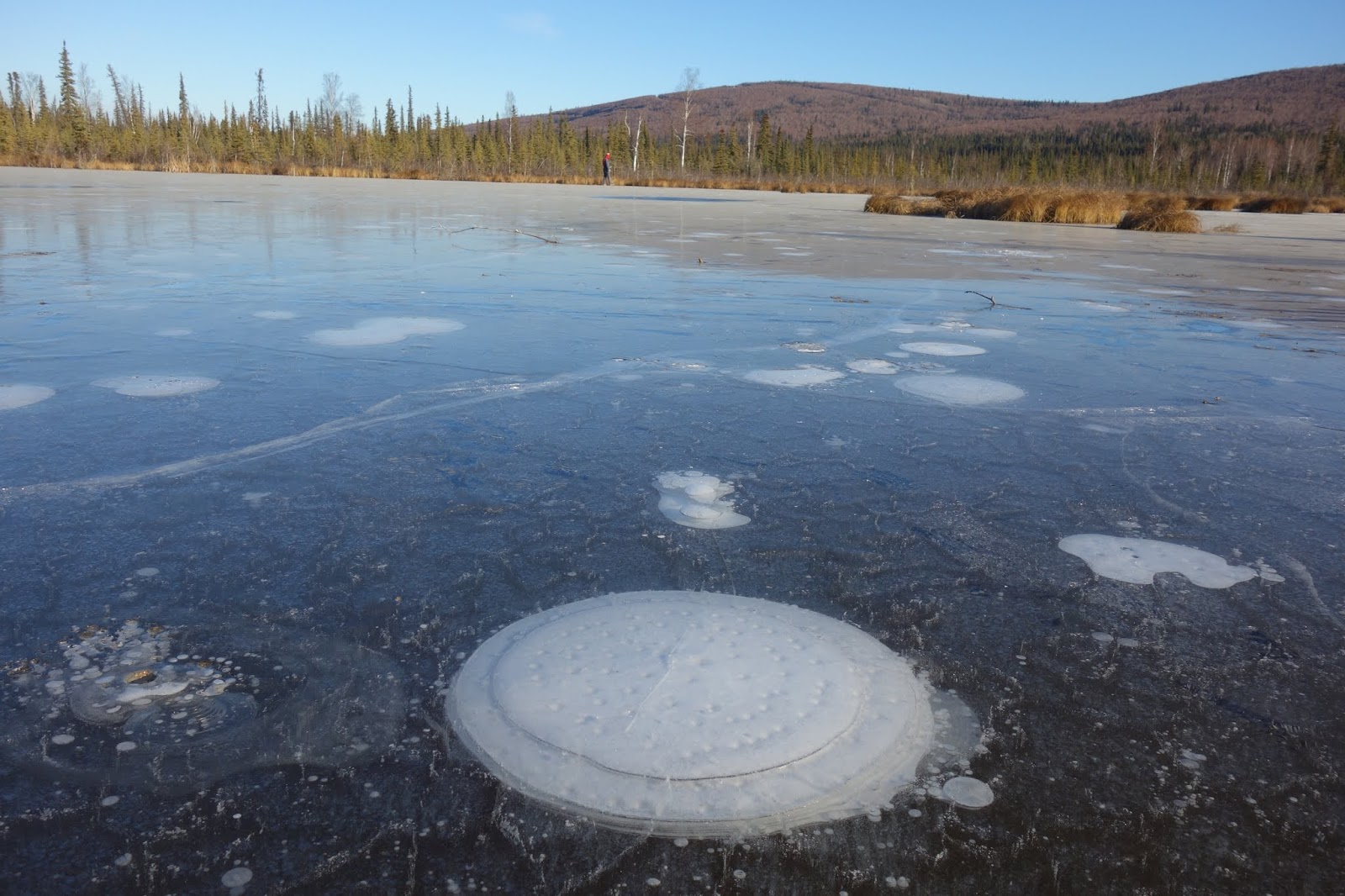
Image above: Methane bubbles up from the thawed permafrost at the bottom of the thermokarst lake through the ice at its surface. Image Credits: Katey Walter Anthony/ University of Alaska Fairbanks.

Team members with the Alfred Wegener Institute (AWI) for Polar and Marine Research in Germany then used U.S. Geological Survey-NASA Landsat satellite imagery from 1999 to 2014 to determine the speed of lake expansion across a large region of Alaska. From this data they were able to estimate the amount of permafrost converted to thawed soil in lake bottoms.

U.S. Geological Survey-NASA Landsat satellite. Image Credits: USGS/NASA

"While lake change has been studied for many regions, the understanding that lake loss and lake gain have a very different outcome for carbon fluxes is new," said co-author Guido Grosse of AWI. "Over a few decades, thermokarst lake growth releases substantially more carbon than lake loss can lock in permafrost again [when the lake bottoms refreeze]."

Because the thermokarst lakes are relatively small and scattered throughout the Arctic landscapes, computer models of their behavior are not currently incorporated into global climate models. However, Walter Anthony believes including them in future models is important for understanding the role of permafrost in the global carbon budget. Human fossil fuel emissions are the number one source of greenhouse gases to the atmosphere, and in comparison, methane emissions from thawing permafrost make up only one percent of the global methane budget, Walter Anthony said. "But by the middle to end of the century the permafrost-carbon feedback should be about equivalent to the second strongest anthropogenic source of greenhouse gases, which is land use change," she said.

To learn more about ABoVE, visit: https://above.nasa.gov/

Earth Research Findings: https://www.nasa.gov/subject/7782/earth-research-findings

Landsat: http://www.nasa.gov/mission_pages/landsat/main/index.html

Climate: https://www.nasa.gov/subject/3127/climate

Images (mentioned), Animation (mentioned), Video (mentioned), Text, Credits: NASA/Sara Blumberg/Earth Science News Team, by Ellen Gray.

Greetings, Orbiter.ch

Robot Science, Spacewalk Preps Ahead of Japanese Cargo Mission


ISS - Expedition 56 Mission patch.

August 17, 2018

 International Space Station (ISS). Animation Credit: NASA

The Expedition 56 crew members explored using algorithms to remotely control a robot on the ground and satellites from the International Space Station today. The orbital residents are also cleaning up after a Russian spacewalk while preparing for a pair of upcoming U.S. spacewalks and a Japanese cargo mission.

Astronaut Alexander Gerst of the European Space Agency is testing the ability to control a robot on a planetary surface from an orbiting spacecraft. The study seeks to bolster the success and safety of future space missions with astronauts and robots sharing decision-making responsibilities.

DLR's Rollin' Justin robot

Image above: This Friday 17 August, ESA astronaut Alexander Gerst will be directing this humanoid robot Rollin’ Justin – based in the DLR German Aerospace Center establishment in Oberpfaffenhofen, Germany – from aboard the International Space Station, flying at 28 800 km/h and 400 km above Earth. Image Credit: DLR.

Commander Drew Feustel joined Flight Engineer Ricky Arnold in the Japanese Kibo lab module monitoring a pair of tiny internal satellites, also known as SPHERES. They are evaluating an algorithm that controls the operation of the SPHERES in formation using six degrees of freedom.

Cosmonauts Oleg Artemyev and Sergey Prokopyev are cleaning up after Wednesday’s spacewalk enabling new science outside of the space station. The two dried out their Russian Orlan spacesuits and water feed lines then began stowing spacewalk tools and gear.


Image above: Roscosmos cosmonaut Sergey Prokopyev lays cable for the installation of the Icarus animal-tracking experiment on the Zvezda service module during a spacewalk that lasted seven hours and 46 minutes. Image Credit: NASA TV.

At the end of the day, Gerst started charging U.S. spacesuit batteries ahead of two maintenance spacewalks planned for Sept. 20 and 26. Gerst and fellow spacewalkers Feustel and Arnold will replace batteries on the Port 4 truss structure’s power channels. The Japanese “Kounotori” HTV-7 cargo ship is targeted to deliver the new batteries ahead of the two spacewalks on Sept. 14.

Related article:

Cosmonauts Wrap Up Russian Spacewalk for Science Work
https://orbiterchspacenews.blogspot.com/2018/08/cosmonauts-wrap-up-russian-spacewalk.html


Related links:

SPHERES: https://www.nasa.gov/mission_pages/station/research/experiments/explorer/Facility.html?#id=1760

Expedition 56: https://www.nasa.gov/mission_pages/station/expeditions/expedition56/index.html

Space Station Research and Technology: https://www.nasa.gov/mission_pages/station/research/index.html

International Space Station (ISS): https://www.nasa.gov/mission_pages/station/main/index.html

Animation (mentioned), Images (mentioned), Text, Credits: ESA/NASA/Mark Garcia.

Best regards, Orbiter.ch

jeudi 16 août 2018

Six Things About Opportunity's Recovery Efforts


NASA - Mars Exploration Rover B (MER-B) patch.

Aug. 16, 2018

NASA's Opportunity rover has been silent since June 10, when a planet-encircling dust storm cut off solar power for the nearly-15-year-old rover. Now that scientists think the global dust storm is "decaying" -- meaning more dust is falling out of the atmosphere than is being raised back into it -- skies might soon clear enough for the solar-powered rover to recharge and attempt to "phone home."

No one will know how the rover is doing until it speaks. But the team notes there’s reason to be optimistic: They’ve performed several studies on the state of its batteries before the storm, and temperatures at its location. Because the batteries were in relatively good health before the storm, there’s not likely to be too much degradation. And because dust storms tend to warm the environment -- and the 2018 storm happened as Opportunity’s location on Mars entered summer -- the rover should have stayed warm enough to survive.


Animation above: Side-by-side movies shows how dust has enveloped the Red Planet, courtesy of the Mars Color Imager (MARCI) wide-angle camera onboard NASA's Mars Reconnaissance Orbiter (MRO). Animation Credits: NASA/JPL-Caltech/MSSS.

What will engineers at NASA's Jet Propulsion Laboratory in Pasadena, California, be looking for -- and what will those signs mean for recovery efforts?

A tau below 2

Dust storms on Mars block sunlight from reaching the surface, raising the level of a measurement called "tau." The higher the tau, the less sunlight is available; the last tau measured by Opportunity was 10.8 on June 10. To compare, an average tau for its location on Mars is usually 0.5.

JPL engineers predict that Opportunity will need a tau of less than 2.0 before the solar-powered rover will be able to recharge its batteries. A wide-angle camera on NASA’s Mars Reconnaissance Orbiter will watch for surface features to become visible as the skies clear. That will help scientists estimate the tau.

Updates on the dust storm and tau can be found here: https://mars.nasa.gov/mer/mission/status_opportunityAll.html

Two Ways to Listen for Opportunity

Several times a week, engineers use NASA’s Deep Space Network, which communicates between planetary probes and Earth, to attempt to talk with Opportunity. The massive DSN antennas ping the rover during scheduled "wake-up" times, and then search for signals sent from Opportunity in response.

In addition, JPL's radio science group uses special equipment on DSN antennas that can detect a wider range of frequencies. Each day, they record any radio signal from Mars over most of the rover's daylight hours, then search the recordings for Opportunity's "voice."

Rover faults out

When Opportunity experiences a problem, it can go into so-called "fault modes" where it automatically takes action to maintain its health. Engineers are preparing for three key fault modes if they do hear back from Opportunity.

- Low-power fault: engineers assume the rover went into low-power fault shortly after it stopped communicating on June 10. This mode causes the rover to hibernate, assuming that it will wake up at a time when there's more sunlight to let it recharge.

- Clock fault: critical to operating while in hibernation is the rover's onboard clock. If the rover doesn't know what time it is, it doesn't know when it should be attempting to communicate. The rover can use environmental clues, like an increase in sunlight, to make assumptions about the time.

- Uploss fault: when the rover hasn't heard from Earth in a long time, it can go into "uploss" fault -- a warning that its communication equipment may not be functioning. When it experiences this, it begins to check the equipment and tries different ways to communicate with Earth.

What happens if they hear back?

After the first time engineers hear from Opportunity, there could be a lag of several weeks before a second time. It's like a patient coming out of a coma: It takes time to fully recover. It may take several communication sessions before engineers have enough information to take action.

Mars Exploration Rover (MER). Image Credits: NASA/JPL-Caltech

The first thing to do is learn more about the state of the rover. Opportunity's team will ask for a history of the rover's battery and solar cells and take its temperature. If the clock lost track of time, it will be reset. The rover would take pictures of itself to see whether dust might be caked on sensitive parts, and test actuators to see if dust slipped inside, affecting its joints.

Once they've gathered all this data, the team would take a poll about whether they're ready to attempt a full recovery.

Not out of the woods

Even if engineers hear back from Opportunity, there's a real possibility the rover won’t be the same.

The rover's batteries could have discharged so much power -- and stayed inactive so long -- that their capacity is reduced. If those batteries can’t hold as much charge, it could affect the rover’s continued operations. It could also mean that energy-draining behavior, like running its heaters during winter, could cause the batteries to brown out.

Dust isn’t usually as much of a problem. Previous storms plastered dust on the camera lenses, but most of that was shed off over time. Any remaining dust can be calibrated out.

Send Opportunity a postcard

Do you miss Opportunity as much as the rover's team? You can write a message sharing your thoughts here: https://mars.nasa.gov/participate/postcard/opportunity-rover/

Read more about Opportunity at: https://mars.nasa.gov/mer/highlights/

Mars Exploration Rovers (Spirit and Opportunity): https://www.nasa.gov/mission_pages/mer/index.html

Deep Space Network: https://deepspace.jpl.nasa.gov/

Animation (mentioned), Image (mentioned), Text, Credits: NASA/JoAnna Wendel​/Tony Greicius/JPL/Andrew Good.

Greetings, Orbiter.ch

Severe Storms Show off their “Plume-age”


NASA logo.

Aug. 15, 2018


Animation above: Easily identifiable in satellite imagery, an Above Anvil Cirrus Plume looks like a plume of smoke emanating out from the top of a storm. The plume is a strong indicator that a storm may produce a tornado, large hail or powerful wind. These plumed storms over North Dakota produced baseball-sized hail. Animation Credit: NASA.

It's not quite a smoking gun, but one could be forgiven for thinking of it that way: a distinctive cloud formation that often signals damaging storms below.

Easily identifiable in satellite imagery, the Above Anvil Cirrus Plume, or AACP, looks like a plume of smoke emanating out from the top of what, in all likelihood, is a serious storm.

"The plume pattern in the imagery instantly tells you without the need for radar or lightning observations or other information that these are the storms you really, really need to look out for," said Kris Bedka, an atmospheric scientist at NASA's Langley Research Center in Hampton, Virginia.

The plumes have been a frequent sight over the U.S. this summer as outbreaks of severe weather have raked across the Midwest, bringing high winds, tornadoes and hail with them.


Image above: In this still image of the North Dakota storms, jet stream air collides with towering updrafts and forms U-shaped areas of cold temperatures shown in blue. The warmer plumes, which are represented by yellow tints, are visible traveling downstream. Image Credit: NASA.

Bedka is studying the AACP phenomenon with colleagues at the University of Oklahoma. Their research is showing that compared to non-plumed storms, plumed storms are significantly more likely to produce high winds, major tornadoes and large hail. In addition, their findings could help weather forecasters provide earlier warnings of severe and tornadic storms not just in the U.S. but around the world.

There are also implications for climate.

“Plume signatures are not only useful for identifying potentially severe storms, but they also represent transport of ice and water vapor into the stratosphere," said Elisa Murillo, a graduate student at the University of Oklahoma who has collaborated extensively with Bedka on AACP research. "Water vapor is a powerful greenhouse gas, and its presence in the stratosphere has strong impacts on climate.”

The Makings of a Plume

To understand why the plumes are such good indicators of severe weather, it helps to understand the conditions that generate them.

Typical thunderstorms top out at the tropopause, the boundary between the troposphere — the lowest part of Earth's atmosphere — and the stratosphere. As storm-producing cumulonimbus clouds hit the tropopause their tops flatten out, giving them an anvil-like appearance.

Plumes form when intense updrafts puncture the tropopause and drag cloud tops up into the stratosphere with them. There, racing stratospheric jet-stream winds and powerful updrafts collide.

"You have wind flows exceeding 100 miles an hour at the jet-stream level running into this towering updraft," said Bedka. "So jet-stream winds are forced to go around."

As the jet-stream air collides with the updraft, it rises slightly and becomes colder, forming a U- or V-shaped area of cold temperatures.


Image above: In May, these plumed storms over northeast Kansas and southern Nebraska produced numerous tornadoes, baseball-sized hail and 80 mph straight-line winds. Image Credit: NASA.

The collision between updraft and jet stream also causes a ripple effect and transports cirrus cloud ice downstream to form the plume. Plumes are typically warmer than the underlying anvil cloud because they mix with the air in the stratosphere where temperature warms with height.

Where there's Smoke…

Over the course of their research, Bedka and his colleagues identified hundreds of plumed storms over the U.S. using highly detailed imagery collected at one-minute intervals by the National Oceanic and Atmospheric Administration's Geostationary Operational Environmental Satellite System, specifically GOES-14 and GOES-16. They then determined when the plumes first formed, how long they lasted and when they decayed.

Next, they linked that satellite data to radar and lightning data from the same storms. They also compared the timing of plume formation to when severe weather actually occurred and when severe weather warnings were issued by the National Weather Service. What they found was significant.

"We found about 400 plume-producing storms across 13 severe weather outbreaks," said Bedka, "and in about 100 of them you had a plume appearing 10 minutes before the first warning, potentially providing additional lead time for saving lives and property."

In a few storms that lead time stretched out even further to about 30 minutes.

The plume-producing storms also generated 14 times more severe weather events per storm than storms without plumes. In addition, 88 percent of EF-2 or greater tornadoes and 86 percent of 2-inch-plus hail reports came from plume-producing storms.

"Identifying this plume feature can be paired with radar observations, routinely available here in the U.S., to improve our warning capabilities," said Murillo. "In many places across the world where radar data are not as accessible, early identification of AACPs can help improve warnings and severe weather preparedness."

Hail, Hail the Cirrus Plume

In terms of cost, storms that drop hail — often storms of the plumed variety — are the most significant.

According to the National Weather Service, hail did $1.7 billion in damage in the U.S. in 2017 — more than all the damage from lightning, tornadoes and thunderstorm winds combined.

If they're big enough, hailstones can shatter glass, dent metal, break shingles and mangle crops. A plumed storm over the Cordoba region of Argentina in February 2018 produced hailstones more than 7 inches in diameter. Hail more than 8 inches in diameter has been recorded over Nebraska and South Dakota in recent years.


Image above: Kris Bedka, atmospheric scientist at NASA's Langley Research Center, is studying Above Anvil Cirrus Plumes with colleagues at the University of Oklahoma. Their research could improve storm warning capabilities in the U.S. and around the world. Image Credits: NASA/David C. Bowman.

Though these extreme hail events are rare, Bedka and colleagues hope their research might add a new dimension to the prediction of the severe storms that generate the most dangerous, expensive weather. They're already collaborating with other scientists to develop an algorithm to automatically detect plumes in satellite imagery.

"The combination of new satellite information such as that from GOES-16 with radar and lightning observations collected from the ground provides an unprecedented package to unravel and provide advance warning of these complex storms," said Bedka.

Bedka and his colleagues published their findings in a study available in early online release (https://journals.ametsoc.org/doi/pdf/10.1175/WAF-D-18-0040.1) through the American Meteorological Society's Weather and Forecasting journal: https://www.ametsoc.org/ams/index.cfm/publications/journals/weather-and-forecasting/

Climate: https://www.nasa.gov/subject/3127/climate

Animation (mentioned), Images (mentioned), Text, Credits: NASA's Langley Research Center/Joe Atkinson.

Greetings, Orbiter.ch

Hubble Paints Picture of the Evolving Universe


NASA - Hubble Space Telescope patch.

Aug. 16, 2018

Astronomers using the ultraviolet vision of NASA’s Hubble Space Telescope have captured one of the largest panoramic views of the fire and fury of star birth in the distant universe. The field features approximately 15,000 galaxies, about 12,000 of which are forming stars. Hubble’s ultraviolet vision opens a new window on the evolving universe, tracking the birth of stars over the last 11 billion years back to the cosmos’ busiest star-forming period, which happened about 3 billion years after the big bang.

Ultraviolet light has been the missing piece to the cosmic puzzle. Now, combined with infrared and visible-light data from Hubble and other space and ground-based telescopes, astronomers have assembled one of the most comprehensive portraits yet of the universe’s evolutionary history.


Image above: Astronomers have just assembled one of the most comprehensive portraits yet of the universe’s evolutionary history, based on a broad spectrum of observations by the Hubble Space Telescope and other space and ground-based telescopes. In particular, Hubble’s ultraviolet vision opens a new window on the evolving universe, tracking the birth of stars over the last 11 billion years back to the cosmos’ busiest star-forming period, about 3 billion years after the big bang. This photo encompasses a sea of approximately 15,000 galaxies — 12,000 of which are star-forming — widely distributed in time and space. This mosaic is 14 times the area of the Hubble Ultra Violet Ultra Deep Field released in 2014. Image Credits: NASA, ESA, P. Oesch (University of Geneva), and M. Montes (University of New South Wales).

The image straddles the gap between the very distant galaxies, which can only be viewed in infrared light, and closer galaxies, which can be seen across a broad spectrum. The light from distant star-forming regions in remote galaxies started out as ultraviolet. However, the expansion of the universe has shifted the light into infrared wavelengths. By comparing images of star formation in the distant and nearby universe, astronomers glean a better understanding of how nearby galaxies grew from small clumps of hot, young stars long ago.

Because Earth’s atmosphere filters most ultraviolet light, Hubble can provide some of the most sensitive space-based ultraviolet observations possible.

Hubble Space Telescope (HST). Animation Credits: NASA/ESA

The program, called the Hubble Deep UV (HDUV) Legacy Survey, extends and builds on the previous Hubble multi-wavelength data in the CANDELS-Deep (Cosmic Assembly Near-infrared Deep Extragalactic Legacy Survey) fields within the central part of the GOODS (Great Observatories Origins Deep Survey) fields. This mosaic is 14 times the area of the Hubble Ultra Violet Ultra Deep Field released in 2014.

This image is a portion of the GOODS-North field, which is located in the northern constellation Ursa Major.

The Hubble Space Telescope is a project of international cooperation between NASA and ESA (European Space Agency). NASA's Goddard Space Flight Center in Greenbelt, Maryland, manages the telescope. The Space Telescope Science Institute (STScI) in Baltimore, Maryland, conducts Hubble science operations. STScI is operated for NASA by the Association of Universities for Research in Astronomy in Washington, D.C.

The science paper by P. Oesch et al.: https://media.stsci.edu/preview/file/science_paper/file_attachment/341/Oesch_published_ApJS_paper.pdf

NASA's Hubble Portal: http://www.nasa.gov/hubble

GOODS-North Field: http://hubblesite.org/image/3300/news_release/2014-05

GOODS-South Field: http://hubblesite.org/image/3920/news_release/2016-39

Ultraviolet Coverage of the Hubble Ultra Deep Field: http://hubblesite.org/image/3380/news_release/2014-27

MAST Portal for Hubble Deep UV (HDUV) Legacy Survey: https://archive.stsci.edu/prepds/hduv/

Image (mentioned), Animation (mentioned), Text, Credits: NASA/Karl Hille/Space Telescope Science Institute/Ann Jenkins/Ray Villard/University of Geneva/Pascal Oesch/University of New South Wales/Mireia Montes.

Best regards, Orbiter.ch

Sun's Magnetic Field Portrayed


NASA - Solar Dynamics Observatory (SDO) patch.

Aug. 16, 2018


NASA's Solar Dynamics Observatory (SDO) scientists used their computer models to generate a view of the Sun's magnetic field on August 10, 2018. The bright active region right at the central area of the Sun clearly shows a concentration of field lines, as well as the small active region at the Sun's right edge, but to a lesser extent. Magnetism drives the dynamic activity near the Sun's surface.

SDO is managed by NASA's Goddard Space Flight Center, Greenbelt, Maryland, for NASA's Science Mission Directorate, Washington. Its Atmosphere Imaging Assembly was built by the Lockheed Martin Solar Astrophysics Laboratory (LMSAL), Palo Alto, California.

SDO (Solar Dynamics Observatory): http://www.nasa.gov/mission_pages/sdo/main/index.html

Image, Text, Credits: NASA/Sarah Loff/GSFC/Solar Dynamics Observatory.

Greetings, Orbiter.ch

mercredi 15 août 2018

Cosmonauts Wrap Up Russian Spacewalk for Science Work


EVA - Extra Vehicular Activities patch / Russian Federation Cosmonaut patch.

August 15, 2018

Expedition 56 Flight Engineers Oleg Artemyev and Sergey Prokopyev of the Russian space agency Roscosmos have completed a spacewalk lasting 7 hours and 46 minutes.


Image above: Cosmonaut Sergey Prokopyev hand-deploys a SiriusSat nano-satellite into Earth orbit while tethered to the Pirs airlock on the International Space Station. Image Credit: NASA TV.

The two cosmonauts opened the hatch to the Pirs docking compartment to begin the spacewalk at 12:17 p.m. EDT. They re-entered the airlock and closed the hatch at 8:03 p.m. EDT.

How to launch satellites by hand

During the spacewalk, the duo manually launched four small technology satellites and installed an experiment called Icarus onto the Russian segment of the space station.


Image above: Image from camera helmet of Cosmonaute Sergey Prokopyev seeing  Cosmonaut Oleg Artemyev at work during today spacewalk. Image Credits: NASA TV/ISS HD-Live/Orbiter.ch Aerospace/Roland Berga.

It was the 212th spacewalk in support of International Space Station assembly, maintenance and upgrades, the third in Artemyev’s career and the first for Prokopyev.

Related links:

Expedition 56: https://www.nasa.gov/mission_pages/station/expeditions/expedition56/index.html

Space Station Research and Technology: https://www.nasa.gov/mission_pages/station/research/index.html

International Space Station (ISS): https://www.nasa.gov/mission_pages/station/main/index.html

Images (mentioned), Video, Text, Credits: NASA/Mark Garcia/NASA TV/SciNews/Orbiter.ch Aerospace/Roland Berga.

Best regards, Orbiter.ch

Cosmonauts Working Outside Station for Russian Spacewalk


EVA - Extra Vehicular Activities patch / Russian Federation Cosmonauts patch.

August 15, 2018

Spacewalk currently underway

Expedition 56 Flight Engineers Oleg Artemyev and Sergey Prokopyev of the Russian space agency Roscosmos began a spacewalk when they opened the hatch of the Pirs docking compartment of the International Space Station at 12:17 p.m. EDT.


Image above: Flight Engineers Oleg Artemyev and Sergey Prokopyev are conducting the 7th spacewalk of the year at the International Space Station today. Image Credit: NASA.

Artemyev will be designated extravehicular crew member 1 (EV1) for the spacewalk wearing the Russian Orlan spacesuit with red stripes. Prokopyev will be extravehicular crew member 2 (EV2) wearing the Russian Orlan spacesuit with blue stripes.


Image above: Russian cosmonaut Oleg Artemyev works outside the International Space Station during a 5-hour, 11-minute spacewalk that took place Aug. 18, 2014, when he was an Expedition 40 Flight Engineer. Image Credit: NASA.

Coverage of the spacewalk continues on NASA Television and the agency’s website. Views from a camera on Artemyev’s helmet are designated with the number 20, and Prokopyev’s is labeled with the number 18.

Related links:

NASA TV: https://www.nasa.gov/nasalive

Expedition 56: https://www.nasa.gov/mission_pages/station/expeditions/expedition56/index.html

Space Station Research and Technology: https://www.nasa.gov/mission_pages/station/research/index.html

International Space Station (ISS): https://www.nasa.gov/mission_pages/station/main/index.html

Images (mentioned), Text, Credits: NASA/Mark Garcia.

Best regards, Orbiter.ch

mardi 14 août 2018

Crew Preps for Russian, U.S. Spacewalks While Juggling Space Research


ISS - Expedition 56 Mission patch.

August 14, 2018

The Expedition 56 crew is getting ready for a spacewalk Wednesday outside the International Space Station’s Russian segment. Meanwhile, the orbital residents continued apace with space science and preparation for a pair of September spacewalks.


Image above: A Russian Orlan spacesuit is pictured inside the Pirs airlock where Russian spacewalks are staged. Image Credit: Roscosmos.

Two cosmonauts will suit up inside their Orlan spacesuits and exit the Pirs airlock Wednesday at 11:58 a.m. EDT for about six hours of science and maintenance work. Oleg Artemyev and Sergey Prokopyev will toss four tiny satellites into space, install antennas and cables for the Icarus animal-tracking experiment and collect exposed science experiments.

NASA astronauts Drew Feustel, Ricky Arnold and Serena Auñón-Chancellor assisted the cosmonauts throughout Tuesday and reviewed their roles for tomorrow’s spacewalk. NASA TV begins its live spacewalk coverage Wednesday at 11:15 a.m.


Image above: Russian cosmonaut Gennady Padalka deploys a small ball-shaped science satellite during a spacewalk at the International Space Station Aug. 20, 2012, during Expedition 32. Image Credit: NASA.

Arnold started his morning replacing gear inside the Combustion Integrated Rack then ended his day with plumbing duty on the Water Processing Assembly. Auñón-Chancellor checked on mice being observed for the Rodent Research-7 study that observes how internal microbes impact organisms living in space.

Finally, European Space Agency astronaut Alexander Gerst spent the afternoon working on U.S. spacesuits. He, Feustel and Arnold are gearing up for two spacewalks at the end of September to replace batteries on the Port 4 truss structure’s power channels.

Related article:

NASA Television to Air Russian Spacewalk at International Space Station
https://www.nasa.gov/press-release/nasa-television-to-air-russian-spacewalk-at-international-space-station

Related links:

NASA Television: https://www.nasa.gov/live

Expedition 56: https://www.nasa.gov/mission_pages/station/expeditions/expedition56/index.html

Combustion Integrated Rack: https://www.nasa.gov/mission_pages/station/research/experiments/explorer/Facility.html?#id=317

Rodent Research-7: https://www.nasa.gov/mission_pages/station/research/experiments/explorer/Investigation.html?#id=7425

Space Station Research and Technology: https://www.nasa.gov/mission_pages/station/research/index.html

International Space Station (ISS): https://www.nasa.gov/mission_pages/station/main/index.html

Images (mentioned), Text, Credits: NASA/Mark Garcia.

Best regards, Orbiter.ch

Hyperspectral Imager Leaves a Legacy of Contributions to Coastal Research


ISS - International Space Station logo.

Aug. 14, 2018

Images of Earth from space are not only beautiful and inspirational, they also provide valuable information for science and commerce that cannot be obtained any other way.

International Space Station (ISS). Animation Credit: NASA

The HICO and RAIDS Experiment Payload (HREP-HICO) created particularly valuable images of a critical part of Earth: its coastal areas. During a five-year run aboard the International Space Station, it collected some 10,000 such images by combining two experimental sensors, the Hyperspectral Imager for the Coastal Ocean (HICO) and the Remote Atmospheric and Ionospheric Detection System (RAIDS).

Scientists, corporations and agencies have used HICO images to estimate concentrations of healthy and harmful phytoplankton, identify Harmful Algal blooms (HABs) in drinking water reservoirs, and assess water quality. HICO also contributed to planning and executing humanitarian relief operations and military actions, and identifying oil spilled from ruptured pipelines.


Image above: The Hyperspectral Imager for Coastal Oceans (HICO) and Remote Atmospheric and Ionospheric Detection System (RAIDS) Experiment Payload on the Japanese Experiment Module - Exposed Facility and the port side Solar Array Wings.
Image Credit: NASA.

“HICO’s ability to look at the coastal oceans was very important for the needs of our planet, helping us understand the coastal environment,” said Mary Kappus, branch head for Coastal and Ocean Remote Sensing at the Naval Research Laboratory, which developed the investigation. “Hyperspectral imagery teaches us more about that environment than regular images. HICO was the first time we put a hyperspectral sensor in space appropriate for looking at coastal oceans.”

HICO was mounted on the exterior of the Japanese Experiment Module Exposed Facility (JEM-EF) in 2009. The space station’s unique orbit offers views that differ from those of traditional Earth-viewing satellites, enabling exceptional views of the coastal ocean and Great Lakes. HICO collected the full spectrum of wavelengths from visible to near-infrared; a regular camera acquires three spectral channels. RAIDS measured the density, temperature, and composition of the ionosphere and thermosphere, regions of Earth’s atmosphere at altitudes between 59 and 186 miles.

HICO met all of its primary mission objectives within its first year, and was subsequently sponsored for mission extensions by both the Office of Naval Research and NASA. In September 2014, HICO’s computer took a severe radiation hit from a solar storm and never recovered. On June 14, 2018, crew members powered down HICO for the last time.

The investigation’s days may have ended, but its work lives on. Most HICO images remain available online. Taking quality images made HREP-HICO a success from the beginning, and the science built on those images add to its success.


Image above: HICO image of algal bloom on Lake Erie, Ohio, in 2011. Image Credit: HICO.

“Researchers have used it to answer science questions about water quality and algal blooms,” Kappus said. “A number of papers have been published on the incidence of algal blooms, which affect many people. We have some idea where they might happen, but are not really good at predicting them. Having images that show where they are and how they develop is important.”

Its legacy also includes advances in the science of remote hyperspectral sensing and important innovations such as improved algorithms to analyze images of coastal zones and advances in processing large amounts of data. An online web application, The Hyperspectral Imager for the Coastal Ocean Image Processing System (HICO IPS), provides cloud-based remote sensing data analysis. Developed by HySpeed Computing, in part through International Space Station National Lab funding and support, HICO IPS provides the global community access to these data.


Image above: HICO image showing eddies along the coast of New Zealand near Christchurch. Image Credit: HICO.

Kappus points to the sheer depth and breadth of phenomena in HCIO’s encyclopedia of images as one of its prime accomplishments. “It was able to show an incredible range of things, images of plumes coming out of a river, eddies, sharp contrasts, even the coastal ocean bottom. It took great images of lakes as well. Many of the images are also beautiful.”

Related links:

HICO and RAIDS Experiment Payload (HREP-HICO): https://www.nasa.gov/mission_pages/station/research/experiments/explorer/Investigation.html?#id=678

Coastal and Ocean Remote Sensing: https://www.nrl.navy.mil/rsd/

Japanese Experiment Module Exposed Facility (JEM-EF): https://www.nasa.gov/mission_pages/station/research/experiments/explorer/Facility.html?#id=134

HICO images: http://hico.coas.oregonstate.edu/

Coastal Ocean Image Processing System (HICO IPS): https://upward.iss-casis.org/constellations-clouds-the-conundrum-of-big-data-processing/

International Space Station National Lab: https://www.nasa.gov/mission_pages/station/research/nlab/index.html

Space Station Research and Technology: https://www.nasa.gov/mission_pages/station/research/index.html

International Space Station (ISS): https://www.nasa.gov/mission_pages/station/main/index.html

Animation (mentioned), Images (mentioned), Text, Credits: NASA/Michael Johnson/JSC/International Space Station Program Science Office/Melissa Gaskill.

Greetings, Orbiter.ch

NASA’s NICER Does the Space Station Twist


ISS - NICER & SEXTANT Mission patch.

Aug. 14, 2018

International Space Station (ISS). Image Credits: NASA/STS-132

This time-lapse video, obtained June 8, 2018, shows the precise choreography of NASA’s Neutron star Interior Composition Explorer (NICER) as it studies pulsars and other X-ray sources from its perch aboard the International Space Station. NICER observes and tracks numerous sources each day, ranging from the star closest to the Sun, Proxima Centauri, to X-ray sources in other galaxies. Movement in the movie, which represents a little more than one 90-minute orbit, is sped up by 100 times.


Animation above: Animation of the NICER on the International Space Station. Animation Credits: NASA's Goddard Space Flight Center.

One factor in NICER’s gyrations is the motion of the space station’s solar arrays, each of which extends 112 feet (34 meters). Long before the panels can encroach on NICER’s field of view, the instrument pirouettes to aim its 56 X-ray telescopes at a new celestial target.

As the movie opens, the station’s solar arrays are parked to prepare for the arrival and docking of the Soyuz MS-09 flight, which launched on June 6 carrying three members of the Expedition 56 crew. Then the panels reorient themselves and begin their normal tracking of the Sun.

NASA’s NICER Does the Space Station Twist

Video above: This time-lapse video, obtained June 8, 2018, shows the precise choreography of NASA's Neutron star Interior Composition Explorer (NICER) as it studies pulsars and other X-ray sources from its perch aboard the International Space Station. Video Credits: NASA's Goddard Space Flight Center/Scientific Visualization Studio.

Neutron stars, also called pulsars, are the crushed cores left behind when massive stars explode. They hold more mass than the Sun in a ball no bigger than a city. NICER aims to discover more about pulsars by obtaining precise measures of their size, which will determine their internal make-up. An embedded technology demonstration, called Station Explorer for X-ray Timing and Navigation Technology (SEXTANT), is paving the way for using pulsars as beacons for a future GPS-like system to aid spacecraft navigation in the solar system — and beyond.

Related links:

Neutron star Interior Composition Explorer (NICER): https://www.nasa.gov/nicer

Soyuz MS-09 flight: https://www.nasa.gov/image-feature/the-soyuz-ms-09-rocket-is-launched

Expedition 56: https://www.nasa.gov/mission_pages/station/expeditions/expedition56/index.html

Station Explorer for X-ray Timing and Navigation Technology (SEXTANT): https://www.nasa.gov/feature/goddard/2018/nasa-team-first-to-demonstrate-x-ray-navigation-in-space

International Space Station (ISS): https://www.nasa.gov/mission_pages/station/main/index.html

Image (mentioned), Animation, Video (mentioned), Text, Credits: NASA/Rob Garner/Goddard Space Flight Center/Claire Saravia.

Greetings, Orbiter.ch

lundi 13 août 2018

Station Gears Up for Spacewalk During Advanced Science Work


ISS - Expedition 56 Mission patch.

August 13, 2018

Two Expedition 56 cosmonauts packed a Russian resupply ship today before preparing for Wednesday’s spacewalk. The other four International Space Station crew members worked on a variety of space science experiments and lab maintenance duties.

Cosmonauts Oleg Artemyev and Sergey Prokopyev are loading a Progress 69 (69P) cargo craft with trash ahead of its departure next week. The 69P delivered over three tons of food, fuel and supplies in February. The spacecraft will undock on Aug. 22 for a fiery disposal over the Pacific Ocean one week later after a series of engineering tests.


Image above: Expedition 56 Flight Engineer Ricky Arnold inspects U.S. spacesuits and tethers in the Quest airlock ahead of a pair of U.S. spacewalks currently planned for September. Image Credit: NASA.

The cosmonauts then turned their attention to Wednesday’s spacewalk when they will hand-deploy four tiny satellites, install antennas and cables and collect exposed science experiments. They continued setting up their spacewalking gear inside the Pirs airlock today. They will exit Pirs Wednesday at 11:58 a.m. EDT for about six hours of work outside the station’s Russian segment inside their Orlan spacesuits. NASA TV’s live coverage of the spacewalk begins at 11:15 a.m.

Commander Drew Feustel and Flight Engineer Serena Auñón-Chancellor performed the majority of the science work today onboard the orbital complex. Feustel explored how proteins crystallize and grow in microgravity to help scientists develop safer, more advanced drug therapies on Earth. Auñón-Chancellor started her day with a blood draw before researching radio spectrum usage in space which may benefit satellite communications. Finally, she studied the sedimentation of quartz and clay particles possibly assisting future planetary exploration missions and the petroleum industry on Earth.


Image above: Flying over North Atlantic Ocean, seen by EarthCam on ISS, speed: 27'622 Km/h, altitude: 408,08 Km, image captured by Roland Berga (on Earth in Switzerland) from International Space Station (ISS) using ISS-HD Live application with EarthCam's from ISS on August 13, 2018 at 20:11 UTC. Image Credits: Orbiter.ch Aerospace/Roland Berga.

Flight Engineer Ricky Arnold spent some time inspecting U.S. spacesuit lights and replacing fan filters before assisting Feustel with the protein crystal growth experiment. Alexander Gerst of ESA checked out U.S. spacesuit batteries then moved on to verifying the functionality of fire extinguishers and breathing masks.

Related links:

Expedition 56: https://www.nasa.gov/mission_pages/station/expeditions/expedition56/index.html

NASA TV’s live coverage of the spacewalk: https://www.nasa.gov/press-release/nasa-television-to-air-russian-spacewalk-at-international-space-station

Proteins crystallize and grow in microgravity: https://www.nasa.gov/mission_pages/station/research/experiments/explorer/Investigation.html?#id=7690

Radio spectrum usage in space: https://www.nasa.gov/mission_pages/station/research/experiments/explorer/Investigation.html?#id=7752

Sedimentation of quartz and clay particles: https://www.nasa.gov/mission_pages/station/research/experiments/explorer/Investigation.html?#id=7668

Space Station Research and Technology: https://www.nasa.gov/mission_pages/station/research/index.html

International Space Station (ISS): https://www.nasa.gov/mission_pages/station/main/index.html

Images (mentioned), Text, Credits: NASA/Mark Garcia/Orbiter.ch Aerospace/Roland Berga.

Best regards, Orbiter.ch

dimanche 12 août 2018

NASA, ULA Launch Parker Solar Probe on Historic Journey to Touch Sun


ULA - Delta IV Heavy / Parker Solar Probe Mission poster.


Aug. 12, 2018

Hours before the rise of the very star it will study, NASA’s Parker Solar Probe launched from Florida Sunday to begin its journey to the Sun, where it will undertake a landmark mission. The spacecraft will transmit its first science observations in December, beginning a revolution in our understanding of the star that makes life on Earth possible.

Roughly the size of a small car, the spacecraft lifted off at 3:31 a.m. EDT on a United Launch Alliance Delta IV Heavy rocket from Space Launch Complex-37 at Cape Canaveral Air Force Station. At 5:33 a.m., the mission operations manager reported that the spacecraft was healthy and operating normally.


Image above: The United Launch Alliance Delta IV Heavy rocket launches NASA's Parker Solar Probe to touch the Sun, Sunday, Aug. 12, 2018, from Launch Complex 37 at Cape Canaveral Air Force Station, Florida. Parker Solar Probe is humanity’s first-ever mission into a part of the Sun’s atmosphere called the corona. Here it will directly explore solar processes that are key to understanding and forecasting space weather events that can impact life on Earth. Image Credits: NASA/Bill Ingalls.

The mission’s findings will help researchers improve their forecasts of space weather events, which have the potential to damage satellites and harm astronauts on orbit, disrupt radio communications and, at their most severe, overwhelm power grids.

“This mission truly marks humanity’s first visit to a star that will have implications not just here on Earth, but how we better understand our universe,” said Thomas Zurbuchen, associate administrator of NASA’s Science Mission Directorate. “We’ve accomplished something that decades ago, lived solely in the realm of science fiction.”

Parker Solar Probe Mission Launches to Touch the Sun

During the first week of its journey, the spacecraft will deploy its high-gain antenna and magnetometer boom. It also will perform the first of a two-part deployment of its electric field antennas. Instrument testing will begin in early September and last approximately four weeks, after which Parker Solar Probe can begin science operations.

“Today’s launch was the culmination of six decades of scientific study and millions of hours of effort,” said project manager Andy Driesman, of the Johns Hopkins University Applied Physics Laboratory (APL) in Laurel, Maryland. “Now, Parker Solar Probe is operating normally and on its way to begin a seven-year mission of extreme science.”

Over the next two months, Parker Solar Probe will fly towards Venus, performing its first Venus gravity assist in early October – a maneuver a bit like a handbrake turn – that whips the spacecraft around the planet, using Venus’s gravity to trim the spacecraft’s orbit tighter around the Sun. This first flyby will place Parker Solar Probe in position in early November to fly as close as 15 million miles from the Sun – within the blazing solar atmosphere, known as the corona – closer than anything made by humanity has ever gone before.


Animation above: Illustration of Parker Solar Probe circling the Sun. Animation Credits: NASA/JHUAPL.

Throughout its seven-year mission, Parker Solar Probe will make six more Venus flybys and 24 total passes by the Sun, journeying steadily closer to the Sun until it makes its closest approach at 3.8 million miles. At this point, the probe will be moving at roughly 430,000 miles per hour, setting the record for the fastest-moving object made by humanity.

Parker Solar Probe will set its sights on the corona to solve long-standing, foundational mysteries of our Sun. What is the secret of the scorching corona, which is more than 300 times hotter than the Sun’s surface, thousands of miles below? What drives the supersonic solar wind – the constant stream of solar material that blows through the entire solar system? And finally, what accelerates solar energetic particles, which can reach speeds up to more than half the speed of light as they rocket away from the Sun?

Scientists have sought these answers for more than 60 years, but the investigation requires sending a probe right through the unrelenting heat of the corona. Today, this is finally possible with cutting-edge thermal engineering advances that can protect the mission on its daring journey.

“Exploring the Sun’s corona with a spacecraft has been one of the hardest challenges for space exploration,” said Nicola Fox, project scientist at APL. “We’re finally going to be able to answer questions about the corona and solar wind raised by Gene Parker in 1958 – using a spacecraft that bears his name – and I can’t wait to find out what discoveries we make. The science will be remarkable.”

Parker Solar Probe carries four instrument suites designed to study magnetic fields, plasma and energetic particles, and capture images of the solar wind. The University of California, Berkeley, U.S. Naval Research Laboratory in Washington, University of Michigan in Ann Arbor, and Princeton University in New Jersey lead these investigations.

Parker Solar Probe is part of NASA’s Living with a Star program to explore aspects of the Sun-Earth system that directly affect life and society. The Living with a Star program is managed by the agency’s Goddard Space Flight Center in Greenbelt, Maryland, for NASA’s Science Mission Directorate in Washington. APL designed and built, and operates the spacecraft.

The mission is named for Eugene Parker, the physicist who first theorized the existence of the solar wind in 1958. It’s the first NASA mission to be named for a living researcher.


Image above: Renowned physicist Eugene Parker watches the launch of the spacecraft that bears his name – NASA’s Parker Solar Probe – early in the morning on Aug. 12, 2018, from Launch Complex 37 at Cape Canaveral Air Force Station in Florida. Image Credits: NASA/Glenn Benson.

A plaque dedicating the mission to Parker was attached to the spacecraft in May. It includes a quote from the renowned physicist – “Let’s see what lies ahead.” It also holds a memory card containing more than 1.1 million names submitted by the public to travel with the spacecraft to the Sun.

For more information on Parker Solar Probe, go to: https://www.nasa.gov/solarprobe

Images (mentioned), Animation (mentioned), Video (NASA TV), Text, Credits: NASA/Dwayne Brown/Karen Fox/Karen Northon/KSC/Tori McLendon/Johns Hopkins University Applied Physics Laboratory/Geoffrey Brown.

Best regards, Orbiter.ch