samedi 6 décembre 2014

Sixth launch for Ariane 5 this year


ARIANESPACE - Ariane 5 Flight VA 221 Mission poster.


6 December 2014

Ariane 5 liftoff on flight VA221

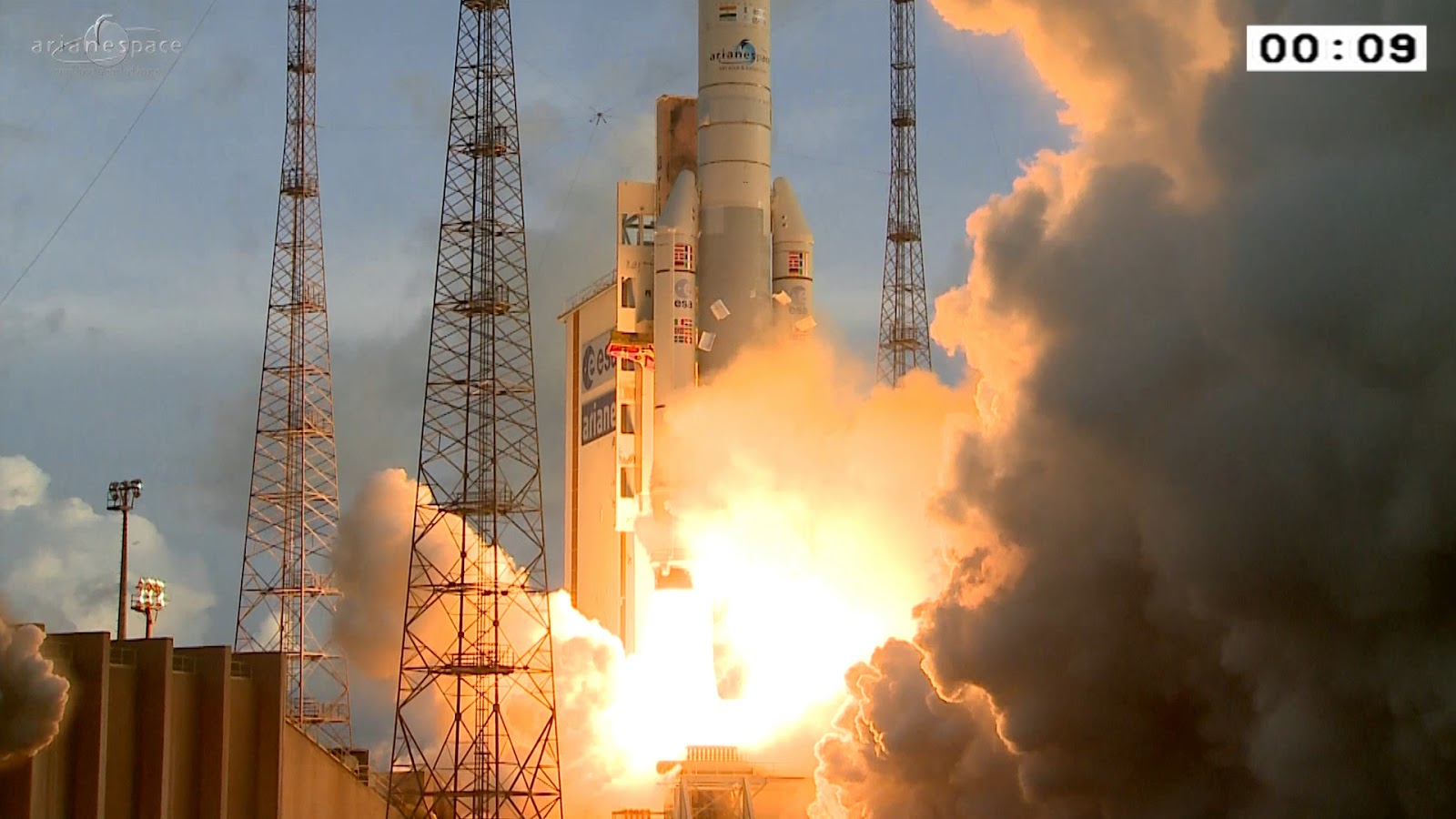
An Ariane 5 has lifted off from Europe’s Spaceport in Kourou, French Guiana and delivered two telecom satellites into their planned orbits.

Launch of flight VA221 occurred on 6 December at 20:40 GMT (21:40 CET, 17:40 local time).

Ariane 5 flight VA221 liftoff replay

DirecTV-14, with a mass of about 6300 kg and mounted on top of Ariane’s Sylda dual-payload carrier, was the first to be released about 28 minutes into the mission.

DirecTV-14 satellite

Following a series of burns controlled by Ariane’s computer, the Sylda structure encasing the 3181 kg GSAT-16 was then jettisoned. GSAT was released into its own transfer orbit about four and a half minutes after the first satellite.

DirecTV-14, owned by DirecTV, will be positioned at 99°W longitude in geostationary orbit to deliver Ultra HD direct-to-home TV across the USA and Puerto Rico. The satellite has a design life of about 15 years.

GSAT-16 satellite

GSAT-16, owned by the Indian Space Research Organization, will be positioned at 55°E in geostationary orbit to augment communication services across India. It has a design life of 12 years.
The payload mass for this launch was 10 352 kg. The satellites totalled 9481 kg, with payload adapters and carrying structures making up the rest.

Flight VA221 was the 77th Ariane 5 mission.

Related links:

Arianespace: http://www.arianespace.com/

About the launcher: http://www.esa.int/Our_Activities/Launchers/Launch_vehicles/Ariane_5_ECA2

Images, Video, Text, Credits: ESA/Arianespace/Gunter Space Page.

Greetings, Orbiter.ch

vendredi 5 décembre 2014

Dawn Snaps Its Best-Yet Image of Dwarf Planet Ceres


NASA - DAWN Mission patch.

December 5, 2014

The Dawn spacecraft has delivered a glimpse of Ceres, the largest body in the main asteroid belt, in a new image taken 740,000 miles (1.2 million kilometers) from the dwarf planet. This is Dawn's best image yet of Ceres as the spacecraft makes its way toward this unexplored world. 


Image above: From about three times the distance from Earth to the moon, NASA's Dawn spacecraft spies its final destination -- the dwarf planet Ceres. This uncropped, unmagnified view of Ceres was taken by Dawn on Dec. 1, 2014. Image Credit: NASA/JPL-Caltech/UCLA/MPS/DLR/IDA.

"Now, finally, we have a spacecraft on the verge of unveiling this mysterious, alien world. Soon it will reveal myriad secrets Ceres has held since the dawn of the solar system," said Marc Rayman, of NASA's Jet Propulsion Laboratory in Pasadena, California, chief engineer and mission director of the Dawn mission.

Dawn will be captured into Ceres' orbit in March, marking the first visit to a dwarf planet by a spacecraft. To date, the best images of Ceres come from the Hubble Space Telescope. In early 2015, however, Dawn will begin delivering images at much higher resolution.


Image above: From about three times the distance from Earth to the moon, NASA's Dawn spacecraft spies its final destination -- the dwarf planet Ceres. This zoomed-in image was taken on Dec. 1, 2014 with the Dawn spacecraft's framing camera. Image Credit: NASA/JPL-Caltech/UCLA/MPS/DLR/IDA.

Since launching in 2007, Dawn has already visited Vesta, a giant protoplanet currently located 104 million miles (168 million kilometers) away from Ceres. The distance between Vesta and Ceres is greater than the distance between the Earth and the sun. During its 14 months in orbit around Vesta, the spacecraft delivered unprecedented scientific insights, including images of its cratered surface and important clues about its geological history. Vesta and Ceres are the two most massive bodies in the main asteroid belt.

The nine-pixel-wide image of Ceres released today serves as a final calibration of the science camera that is necessary before Dawn gets to Ceres. The dwarf planet appears approximately as bright as Venus sometimes appears from Earth. Ceres has an average diameter of about 590 miles (950 kilometers).


Image above: The Dawn spacecraft acquired this view as part of a calibration of its science camera. Ceres is the bright spot in the center of the image. A cropped, magnified view of Ceres appears in the inset image at lower left. Image Credit: NASA/JPL-Caltech/UCLA/MPS/DLR/IDA.

Dawn begins its approach phase toward Ceres on December 26.

The Dawn mission to Vesta and Ceres is managed by NASA's Jet Propulsion Laboratory, a division of the California Institute of Technology in Pasadena, for NASA's Science Mission Directorate, Washington D.C. UCLA is responsible for overall Dawn mission science. The Dawn framing cameras were developed and built under the leadership of the Max Planck Institute for Solar System Research, Gottingen, Germany, with significant contributions by German Aerospace Center (DLR), Institute of Planetary Research, Berlin, and in coordination with the Institute of Computer and Communication Network Engineering, Braunschweig. The Framing Camera project is funded by the Max Planck Society, DLR, and NASA/JPL.

More information about Dawn is online at http://dawn.jpl.nasa.gov.

Images (mentioned), Text, Credits: NASA/JPL/Elizabeth Landau.

Greetings, Orbiter.ch

Warm Gas Pours 'Cold Water' on Galaxy's Star-Making


ESA - HerschelMission patch / NASA - Spitzer Space Telescope logo / NASA - Hubble Space Telescope patch.

December 5, 2014


Image above: A new feature in the evolution of galaxies has been captured in this image of galactic interactions. Image Credit: NASA/CFHT/NRAO/JPL-Caltech/Duc/Cuillandre.

Some like it hot, but for creating new stars, a cool cosmic environment is ideal. As a new study suggests, a surge of warm gas into a nearby galaxy -- left over from the devouring of a separate galaxy -- has extinguished star formation by agitating the available chilled gas.  

The unique findings illustrate a new dimension to galaxy evolution, and come courtesy of the European Space Agency's Herschel space observatory, in which NASA played a key role, and NASA's Spitzer and Hubble space telescopes.

Herschel space observatory. Image Credit: ESA

Astronomers want to understand why galaxies in the local universe fall into two major categories: younger, star-forming spirals (like our own Milky Way), and older ellipticals, in which fresh star making has ceased. The new study's galaxy, NGC 3226, occupies a transitional middle ground, so getting a bead on its star formation is critical.   

"We have explored the fantastic potential of big data archives from NASA's Hubble, Spitzer and ESA's Herschel observatory to pull together a picture of an elliptical galaxy that has undergone huge changes in its recent past due to violent collisions with its neighbors," said Philip Appleton, project scientist for the NASA Herschel Science Center at the California Institute of Technology in Pasadena and lead author of a recent Astrophysical Journal paper detailing the results. "These collisions are modifying not only its structure and color, but also the condition of the gas that resides in it, making it hard -- at the moment -- for the galaxy to form many stars."

NGC 3226 is relatively close, just 50 million light-years away. Several star-studded, gassy loops emanate from NGC 3226. Filaments also run out from it and between a companion galaxy, NGC 3227. These streamers of material suggest that a third galaxy probably existed there until recently -- that is, until NGC 3226 cannibalized it, strewing pieces of the shredded galaxy all over the area.

A prominent piece of these messy leftovers stretches 100,000 light-years and extends right into the core of NGC 3226. This long tail ends as a curved plume in a disk of warm hydrogen gas and a ring of dust. Contents of the tail, thought to be the debris from that departed galaxy, are falling into NGC 3226, drawn by its gravity.

Spitzer Space Telescope. Image Credit: NASA

In many instances, adding material to galaxies in this manner rejuvenates them, triggering new rounds of star birth thanks to gas and dust gelling together. Yet data from the three telescopes agree that NGC 3226 has a very low rate of star formation. It appears that in this case, the material falling into NGC 3226 is heating up as it collides with other galactic gas and dust, quenching star formation instead of fueling it.

The outcome could have been different, as NGC 3226 hosts a supermassive black hole at its center. The influx of gas and dust might have ended up just feeding the black hole, setting off energetic outpourings as the material crashed together while whirling toward its doom. Instead, the black hole in NGC 3226's core is just snacking, not gorging, as the material has spread out in the galaxy's central regions.

"We are discovering that gas does not simply funnel down into the center of a galaxy and feed the supermassive black hole known to be lurking there," Appleton said. "Rather, it gets hung up in a warm disk, shutting down star formation and probably frustrating the black hole's growth by being too turbulent at this point in time."

NGC 3226 is considered something between a youthful "blue" galaxy and an old "red" galaxy. The colors refer to the predominantly galactic blue light radiated by giant, young stars -- a telltale sign of recent star formation -- and the reddish light cast by mature stars in the absence of new, blue ones.

This intermediary galaxy illuminates how galaxies accruing fresh gas and dust can bloom with new stars or have their stellar factories close shop, at least temporarily. After all, as the warm gas flooding NGC 3226 cools to star-forming temperatures, the galaxy should get a second wind.

Intriguingly, ultraviolet and optical light observations suggest that NGC 3226 may have produced more stars in the past, leading to its current intermediate color, somewhere between red and blue. The new study indicates that those traces of youth must indeed be lingering from higher levels of star formation, before the infalling gas scrambled the scene.

Hubble Space Telescope. Image Credit: NASA/ESA

"NGC 3226 will continue to evolve and may hatch abundant new stars in the future," said Appleton. "We're learning that the transition from young- to old-looking galaxies is not a one-way, but a two-way street."

Other authors of the report are: C. Mundell of Liverpool John Moores University, England; M. Lacy of National Radio Astronomy Observatory, Charlottesville, Virginia; V. Charmandaris of University of Creete, Greece; P-A. Duc of CEA-Saclay, France; U. Lisenfeld of University of Granda, Spain; and T. Bitsakis, K. Alatalo, L. Armus and P. Ogle of Caltech.

Herschel is a European Space Agency mission, with science instruments provided by consortia of European institutes and with important participation by NASA. While the observatory stopped making science observations in April 2013, after running out of liquid coolant, as expected, scientists continue to analyze its data. NASA's Herschel Project Office is based at NASA's Jet Propulsion Laboratory, Pasadena, California. JPL contributed mission-enabling technology for two of Herschel's three science instruments. The NASA Herschel Science Center, part of the Infrared Processing and Analysis Center at Caltech, supports the U.S. astronomical community.

JPL manages the Spitzer Space Telescope mission for NASA's Science Mission Directorate, Washington. Science operations are conducted at the Spitzer Science Center at Caltech. Spacecraft operations are based at Lockheed Martin Space Systems Company, Littleton, Colorado. Data are archived at the Infrared Science Archive housed at the Infrared Processing and Analysis Center at Caltech.

Caltech manages JPL for NASA.

The Hubble Space Telescope is a project of international cooperation between NASA and the European Space Agency. NASA's Goddard Space Flight Center in Greenbelt, Maryland, manages the telescope. The Space Telescope Science Institute (STScI) in Baltimore conducts Hubble science operations. STScI is operated for NASA by the Association of Universities for Research in Astronomy, Inc., in Washington.

Fore more information about NASA's role in Herschel, visit: http://www.nasa.gov/herschel

For more information about Spitzer, visit: http://www.nasa.gov/spitzer

For more information about Hubble, visit: http://www.nasa.gov/hubble

Images (mentioned), Text, Credits: NASA/JPL/Whitney Clavin.

Cheers, Orbiter.ch

LIFTOFF! Orion Begins New Era in Space Exploration!


NASA - Orion EFT-1 Mission patch / ULA - Delta IV Heavy EFT Mission patch.

December 5, 2014

 Launch of Orion. Photo Credit: NASA/Bill Ingalls

The Orion spacecraft is heading into orbit on the brilliant fire and power of the United Launch Alliance Delta IV Heavy rocket! Orion launched from Cape Canaveral this morning at 7:05 a.m EST (12:05 GMT).

Orion Soars on First Flight Test

Booster Burnout and Jettison


The core stages to the left and right on the rocket burned through their propellants in less than four minutes and have fallen away. A single core stage is now powering Orion toward space. The second stage will take over in 93 seconds.

Fairing Jettison Image


A camera aboard the Delta IV Heavy recorded the separation of the fairing panels over the Orion service module during the climb into orbit. The fairing provided structural support during the early phases of launch.

Second Stage Engine Cutoff – Orion’s In Orbit


The second stage engine completed its first burn and Orion is in orbit now, on a path that is about 560 miles by 120 miles above Earth. There will be another burn by the Delta IV second stage to lift its orbit and then push it out 3,600 miles from Earth. For now, though, Orion begins a coast phase of about 97 minutes. The second stage will reignite at the 1 hour, 55 minute, 26 second point of the mission. The coast phase will allow flight controllers to continue evaluating telemetry coming down from the spacecraft and make sure Orion is healthy thus far in its mission.

Second Stage Ignites to Lift Orbit

Upper Stage Re-Ignition animation

The single engine of the second stage is firing now, using its 24,750 pounds of thrust to push Orion higher above Earth. This burn will last 4 minutes and 42 seconds and place Orion on a path through the Van Allen radiation belts and then back to Earth’s atmosphere at high speed.

Peak Heating


Orion continues to slow down quickly as the atmosphere it flies through gets thicker and thicker. The thickening air also generates more heat and the spacecraft is now passing through that hottest part of reentry.

Main Chutes Deployed!


Orion is falling gently toward the Pacific Ocean surface under three parachutes that combined would cover a football field.

Orion on the Ocean Surface


The Orion capsule landed upright on its base in a position called Stable 1 and remains in Stable 1 as it floats on the Pacific’s surface. The spacecraft’s systems performed perfectly throughout the mission including two passes through the Van Allen radiation belts and the heat of re-entry.

 Orion Splashes Down in the Pacific Ocean

Critical Step on the Journey to Mars

The Orion crew module splashed down in the Pacific Ocean approximately 600 southwest of San Diego at 11:29 a.m. EST. Flight controllers have reported that the spacecraft is in a stable configuration. The recovery team from NASA, the U.S. Navy and Lockheed Martin will perform initial recovery operations, including safing the crew module and towing it into the well deck of the USS Anchorage ahead of its return to U.S. Naval Base, San Diego and then on to NASA’s Kennedy Space Center in Florida. Orion launched from Cape Canaveral this morning at 7:05 a.m. EST (12:05 GMT).

Orion Explore and Beyond

For more information about Orion Crew Module, visit: http://www.nasa.gov/orion/

Images, Videos, Text, Credits: NASA/Bill Ingalls/NASA blog/NASA TV/Screen captures from NASA TV by Orbiter.ch Aerospace.

Best regards, Orbiter.ch

jeudi 4 décembre 2014

European Astronomers spot faint asteroid


Asteroid Watch logo.

4 December 2014

European experts have spotted one of the faintest asteroids ever found – a chunk of space rock thought to be about 100 m in diameter beyond the orbit of Mars.

Asteroid

Astronomers at the Large Binocular Telescope in Arizona, USA, spotted 2014 KC46 on the nights of 28 and 30 October. The difficult observations, close to the limits of the telescope, were carried out through a new collaboration between the Italian telescope team and ESA’s Near-Earth Object (NEO) Coordination Centre near Rome.

The observations marked the ‘recovery’ of the asteroid – it had been seen before but then lost. This was one of the faintest recoveries of a NEO ever achieved.

Spotting a space rock

The telescope, operated by a group of institutes including the Italian National Institute for Astrophysics, spotted the object – which is about as wide as a football pitch – just beyond the orbit of Mars.

The measurement of its position was sufficiently accurate to refine its orbital path and eliminate any possibility that it might hit Earth in the near future.

“This success highlights the importance of quick response and cooperation across the asteroid community in verifying NEO orbits,” says Detlef Koschny, Head of the NEO Segment in ESA’s Space Situational Awareness programme office.

Asteroid orbit

“It also proved the effectiveness of the telescope in detecting faint objects that have large positional uncertainties.”

The measurements have been accepted by the International Astronomical Union’s Minor Planet Center, the organisation responsible for collecting data for small bodies of the Solar System.

Dual-mirror view of the solar system

The observation of this asteroid was made possible by the unique performance of the telescope, which features a large field of view combined with the ability to spot very faint objects thanks to the twin 8.4 m-diameter mirrors.

The telescope sits at an altitude of 3200 m on Mt Graham in Arizona and has a light-gathering power equivalent to a single 11.8 m-diameter instrument.

It is a collaboration between the Instituto Nazionale di Astrofisica, the University of Arizona, Arizona State University, Northern Arizona University, LBT Beteiligungsgesellschaft in Germany, Ohio State University, the Research Corporation in Tucson and the University of Notre Dame.

Space Situational Awareness - Near Earth Objects (Artist's concept)

ESA’s NEO Segment coordinates and combines information from different sources, analyses them to predict possible Earth impacts, assesses the danger and analyses possible mitigation measures, including the deflection of a threatening asteroid.

The NEO Coordination Centre at ESA’s establishment in Frascati, near Rome, provides data and services on NEO hazards and coordinates follow-up astronomical observations.

More information:

Minor Planet Center: http://www.minorplanetcenter.org/iau/mpc.html

Spaceguard Central Node: http://spaceguard.rm.iasf.cnr.it/

European Asteroid Research Node: http://earn.dlr.de/

Near-Earth Objects - Dynamic Site: http://newton.dm.unipi.it/neodys/

UK Spaceguard Centre: http://www.spaceguarduk.com/

Related links:

NASA NEO Office: http://neo.jpl.nasa.gov/

NEO mission studies: http://www.esa.int/Our_Activities/Space_Engineering_Technology/NEO

Torino impact hazard scale: http://neo.jpl.nasa.gov/torino_scale.html

Palermo Technical Impact Hazard Scale: http://neo.jpl.nasa.gov/risk/doc/palermo.html

UNOOSA/UN-SPIDER: http://www.un-spider.org/

Large Binocular Telescope: http://www.lbto.org/index.htm

INAF: http://www.inaf.it/

Images, Text, Credits: ESA/P.Carril/LBTO/INAF.

Greetings, Orbiter.ch

Flight Status of Micro Deep-Space Explorer "PROCYON"


JAXA logo.

December 4, 2014

The University of Tokyo and the Japan Aerospace Exploration Agency (JAXA) received signals from the Micro deep-space explorer "PROCYON" at 8:51 p.m. on December 3, 2014 (Japan Standard Time), to confirm it had been inserted into the scheduled interplanetary orbit.

PROCYON spacecraft

The satellite is now in the initial operation phase. PROCYON was launched by the H-IIA Launch Vehicle No. 26 as a secondary payload of the Asteroid Explorer "Hayabusa2" at 1:22:04 p.m. on Dec. 3, 2014 (JST) from the Tanegashima Space Center.


Related link:

H-IIA Launch Vehicle: http://global.jaxa.jp/projects/rockets/h2a/

For more information about PROCYON, visit: http://www.jaxa.jp/press/2014/12/20141204_procyon_j.html

Images, Text, Credits: Japan Aerospace Exploration Agency (JAXA)/The University of Tokyo.

Cheers, Orbiter.ch

mercredi 3 décembre 2014

Timing carbon turnover


ESA -European Space Agency patch.

3 December 2014

Scientists are using satellite data to improve understanding of the time it takes for a carbon atom fixed in a plant by photosynthesis to return into the atmosphere as carbon dioxide – known as ‘carbon turnover’.

Forests play a crucial role in Earth’s carbon cycle. In general, forests are ‘carbon sinks’ as they absorb and store carbon dioxide from the atmosphere. Forests that are logged or burnt down, however, release parts of the stored carbon into the atmosphere.

According to a study published in Nature, the global average carbon turnover is 23 years. But the study shows, for the first time, how this turnover time varies in different regions around the world.

Turnover times

To derive these figures on carbon stores and turnover, the scientists used forest carbon stock estimates from Earth observation data. For boreal and temperate forests, these were based on radar data from ESA’s veteran Envisat mission.

About 70 000 Envisat ASAR radar images acquired between October 2009 and February 2011 were fed into a hypertemporal algorithm developed by the Swiss Gamma Remote Sensing corporation and Germany’s University of Jena to obtain the required information over the northern hemisphere.

“The objective of our work was to serve the scientific community with a data product that could enhance knowledge of key processes in northern latitudes,” said Maurizio Santoro, from Gamma.

“In this sense, public availability of the forest biomass information derived from the ASAR data is seen as a means to foster studies on such processes.”

In the Tropics, the average carbon turnover time is 15 years, while at higher latitudes it takes some 255 years for the stored carbon atom to be released. As expected, these latitudinal patterns are strongly dependent on temperature: the warmer it is, the faster dead biomass degrades.

Precipitation showed to be just as important in determining how quickly carbon is converted in an ecosystem. In the savannahs and even in tropical grasslands, carbon turnover time decreases as precipitation increases.

Northern biomass

“This is completely plausible, as the microorganisms that are involved in the decomposition of plants need water for their metabolism,” said Nuno Carvalhais from the Max Planck Institute for Biogeochemistry in Jena, Germany, who led the study.

“It takes much longer for a dead plant to decompose in a desert than it does in the rainforest.”

The study also revealed that land ecosystems store approximately 2800 billion tonnes of carbon – around 400 billion tonnes more than previous studies had estimated.

This new information on carbon turnover provides new insight into how land ecosystems respond to global warming, and will be used to improve global climate models and assist in climate forecasting. However, it is still unclear how climate forecasts will change as a result of more precise carbon balancing.

Biomass

Looking to the future, the delivery of multiyear retrievals from ESA’s future Biomass satellite mission will provide a unique opportunity to study the changes in forest carbon storage and, in the long term, its potential links to changes in climate.

Until then, the new ESA GlobBiomass project will prepare the pathway for a synergistic Earth observation approach to improve carbon stocks globally.

GlobBiomass exploits archived radar and optical data – including data from the Sentinel fleet of satellites – to develop new algorithms in cooperation with expert teams from across the globe.

Related links:

Gamma Remote Sensing: http://www.gamma-rs.ch/

Biomasar project: http://www.biomasar.org/

University of Jena: http://www.uni-jena.de/en/start.html

Max Planck Institute for Biogeochemistry: https://www.bgc-jena.mpg.de/

Support to Science Element: http://due.esrin.esa.int/stse/

Related missions:

Envisat: http://www.esa.int/Our_Activities/Observing_the_Earth/Envisat

Biomass: http://esamultimedia.esa.int/docs/EarthObservation/BIOMASS_sheet_130611.pdf

Images, Text, Credits: ESA/N. Carvalhais/S. Schott/MPI-BGC/Biomasar-II/AOES Medialab.

Best regards, Orbiter.ch

Galileo satellite recovered and transmitting navigation signals


ESA - Galileo Navigation Satellites logo.

3 December 2014

Europe’s fifth Galileo satellite, one of two delivered into a wrong orbit by VS09 Soyuz-Fregat launcher in August, has transmitted its first navigation signal in space on Saturday 29 November 2014. It has reached its new target orbit and its navigation payload has been successfully switched on.

Galileo satellite

A detailed test campaign is under way now the satellite has reached a more suitable orbit for navigation purposes.

Recovery

The fifth and sixth Galileo satellites, launched together on 22 August, ended up in an elongated orbit travelling up to 25 900 km above Earth and back down to 13 713 km.

A total of 11 manoeuvres were performed across 17 days, gradually nudging the fifth satellite upwards at the lowest point of its orbit.

As a result, it has risen more than 3500 km and its elliptical orbit has become more circular.

“The manoeuvres were all normal, with excellent performance both in terms of thrust and direction,” explained Daniel Navarro-Reyes, ESA Galileo mission analyst.

Galileo satellite's revised orbit

The commands were issued from the Galileo Control Centre by Space Opal, the Galileo operator, at Oberpfaffenhofen in Germany, guided by calculations from a combined flight dynamics team of ESA’s Space Operations Centre, ESOC, in Darmstadt, Germany and France’s CNES space agency.

The commands were uploaded to the satellite via an extended network of ground stations, made up of Galileo stations and additional sites coordinated by France’s CNES space agency.

Satellite manufacturer OHB also provided expertise throughout the recovery, helping to adapt the flight procedures.

Until the manoeuvres started, the combined ESA–CNES team maintained the satellites pointing at the Sun using their gyroscopes and solar sensors. This kept the satellites steady in space but their navigation payloads could not be used reliably.

In the new orbit, the satellite’s radiation exposure has also been greatly reduced, ensuring reliable performance for the long term.

A suitable orbit

The revised, more circular orbit means the fifth satellite’s Earth sensor can be used continuously, keeping its main antenna oriented towards Earth and allowing its navigation payload to be switched on.

Significantly, the orbit means that it will now overfly the same location on the ground every 20 days. This compares to a normal Galileo repeat pattern of every 10 days, effectively synchronising its ground track with the rest of the Galileo constellation.

The navigation test campaign

The satellite’s navigation payload was activated on 29 November, to begin the full ‘In-Orbit Test’ campaign. This is being performed from ESA’s Redu centre in Belgium, where a 20 m-diameter antenna can study the strength and shape of the navigation signals at high resolution.

“First, the various payload elements, especially the Passive Hydrogen Maser atomic clock, were warmed up, then the payload’s first ‘signal in space’ was transmitted,” said David Sanchez-Cabezudo, managing the test campaign.

Controlling Galileo

“The satellite-broadcast L-band navigation signal is monitored using the large antenna at Redu, with experts from OHB and Surrey Satellite Technology Ltd – the payload manufacturer, based in Guildford, UK – also on hand to analyse how it performs over time.”

The first Galileo FOC navigation signal-in-space transmitting in the three Galileo frequency bands (E5/E6/L1) was tracked  by Galileo Test User Receivers deployed at various locations in Europe, namely at Redu (B), ESTEC (NL), Weilheim (D) and Rome (I). The quality of the signal is good and in line with expectations.

The Search And Rescue (SAR) payload will be switched on in few days in order to complement the in-orbit test campaign.

The way forward

The same recovery manoeuvres are planned for the sixth satellite, taking it into the same orbital plane but on the opposite side of Earth.

Galileo L-band antenna at Redu

The decision whether to use the two satellites for Navigation and SAR purposes as part of the Galileo constellation will be taken by the European Commission based on the test results.

About Galileo

Galileo is Europe’s own global satellite navigation system. It will consist of 30 satellites and their ground infrastructure.

The definition phase and the development and In-Orbit Validation phase of the Galileo programme were carried out by the European Space Agency (ESA) and co-funded by ESA and the European Union. This phase has created a mini-constellation of four satellites and a reduced ground segment dedicated to validating the overall concept.

Full Galileo constellation

The four satellites launched during the IOV phase form the core of the constellation that is being extended to reach Full Operational Capability (FOC).

The FOC phase is fully funded by the European Commission. The Commission and ESA have signed a delegation agreement by which ESA acts as design and procurement agent on behalf of the Commission.

Learn more about Galileo at: http://www.esa.int/Our_Activities/Navigation

About the European Space Agency

The European Space Agency (ESA) provides Europe’s gateway to space.

ESA is an intergovernmental organisation, created in 1975, with the mission to shape the development of Europe’s space capability and ensure that investment in space delivers benefits to the citizens of Europe and the world.

ESA has 20 Member States: Austria, Belgium, the Czech Republic, Denmark, Finland, France, Germany, Greece, Ireland, Italy, Luxembourg, the Netherlands, Norway, Poland, Portugal, Romania, Spain, Sweden, Switzerland and the United Kingdom, of whom 18 are Member States of the EU. Two other Member States of the EU, Hungary and Estonia, are likely soon to become new ESA Member States.

ESA has Cooperation Agreements with six other Member States of the EU. Canada takes part in some ESA programmes under a Cooperation Agreement.

ESA is also working with the EU on implementing the Galileo and Copernicus programmes.

By coordinating the financial and intellectual resources of its members, ESA can undertake programmes and activities far beyond the scope of any single European country.

ESA develops the launchers, spacecraft and ground facilities needed to keep Europe at the forefront of global space activities.

Today, it develops and launches satellites for Earth observation, navigation, telecommunications and astronomy, sends probes to the far reaches of the Solar System and cooperates in the human exploration of space.

Learn more about ESA at http://www.esa.int

Related links:

ESOC - European Space Operations Centre: http://www.esa.int/About_Us/ESOC

Team of teams: http://www.esa.int/Our_Activities/Operations/Highlights/Team_of_teams

Flight Dynamics: http://www.esa.int/Our_Activities/Operations/Ground_Systems_Engineering/Flight_Dynamics

Images, Text, Credits: ESA/P. Carril.

Cheers, Orbiter.ch

Launch Success of H-IIA Launch Vehicle No. 26 with "Hayabusa 2" Onboard


JAXA - Hayabusa 2 Mission logo.

December 3, 2014 (JST)

Launch of H-IIA Launch Vehicle No. 26 with "Hayabusa2" Onboard

Mitsubishi Heavy Industries, Ltd. and the Japan Aerospace Exploration Agency (JAXA) successfully launched the H-IIA Launch Vehicle No. 26 (H-IIA F26) with the Asteroid Explorer “Hayabusa2” onboard at 1:22:04 p.m. on December 3, 2014 (Japan Standard Time, JST) from the Tanegashima Space Center. The launch vehicle flew as planned, and at approximately one hour, 47 minutes and 21 seconds after liftoff, the separation of the Hayabusa2 to earth-escape trajectory was confirmed.

With a launch success rate for H-IIA/B launch vehicles at 96.7%, this launch confirms the quality and reliability of the H-IIA/B.

The Asteroid Explorer “Hayabusa2” is a successor to the “Hayabusa”, which verified various new exploration technologies and returned to Earth in June 2010. The “Hayabusa2” is setting out on a journey to clarify the origin and evolution of the solar system as well as life matter. The “Hayabusa2” will find out more about the world.

Hayabusa 2 approaching the asteroid

We would like to express our profound appreciation for the cooperation and support of all related personnel and organizations that helped contribute to the successful launch of the H-IIA F26.

The Japan Aerospace Exploration Agency (JAXA) received signals from the Asteroid Explorer "Hayabusa2" at 3:44 p.m. on December 3, 2014 (Japan Standard Time) at the NASA Goldstone Deep Space Communication Complex (in California) and confirmed that its initial sequence of operations including the solar array paddle deployment and sun acquisition control have been performed normally.

Hayabusa 2 collecting samples on the asteroid

The Hayabusa2 was launched on the H-IIA Launch Vehicle No. 26 from the Tanegashima Space Center at 1:22:04 p.m.on the same day (JST.) The explorer is also confirmed to be inserted into the scheduled orbit by the H-IIA F26.

The explorer is now in a stable condition.

For more information about the Hayabusa2, please refer to the following JAXA website "Hayabusa2 special site": http://global.jaxa.jp/projects/sat/hayabusa2/index.html

Images, Video, Text, Credits: Japan Aerospace Exploration Agency (JAXA)/Mitsubishi Heavy Industries, Ltd.

Greetings, Orbiter.ch

mardi 2 décembre 2014

Stardust Not Likely to Block Planet Portraits


W. M. Keck Observatory telescopes logo.

December 2, 2014


Image above: A dusty planetary system (left) is compared to another system with little dust in this artist's conception. Image Credit: NASA/JPL-Caltech.

Planet hunters received some good news recently. A new study concluded that, on average, sun-like stars aren't all that dusty. Less dust means better odds of snapping clear pictures of the stars' planets in the future.

These results come from surveying nearly 50 stars from 2008 to 2011 using the Keck Interferometer, a former NASA key science project that combined the power of the twin W. M. Keck Observatory telescopes atop Mauna Kea, Hawaii.

"Dust is a double-edged sword when it comes to imaging distant planets," explained Bertrand Mennesson of NASA's Jet Propulsion Laboratory, Pasadena, California, lead author of an Astrophysical Journal report to be published online Dec. 8. "The presence of dust is a signpost for planets, but too much dust can block our view." Mennesson has been involved in the Keck Interferometer project since its inception more than 10 years ago, both as a scientist and as the optics lead for one of its instruments.

Ground- and space-based telescopes have already captured images of exoplanets -- planets orbiting stars beyond our sun. These early images, which show giant planets in cool orbits far from the glow of their stars, represent a huge technological leap. The glare from stars can overwhelm the light of planets, like a firefly buzzing across the sun. So, researchers have developed complex instruments to block the starlight, allowing information about the planet to shine through.

The next challenge is to image smaller planets in the "habitable" zone around stars where possible life-bearing "exo-Earths" -- Earth-like planets outside the solar system -- could reside. Such a lofty goal may take decades, but researchers are already on the path to getting there, developing new instrument designs and analyzing the dust kicked up around stars to better understand how to snap crisp planetary portraits. Scientists want to find out which stars have the most dust, and how dusty the habitable zones of sun-like stars are.

The Keck Interferometer was built to seek out this dust, and to ultimately help in the design and target selection of future NASA exo-Earth missions. Like planets around other stars, dust near a star is also hard to detect. Interferometry is a high-resolution imaging technique that can be used to block out a star's light, making the region nearby easier to observe. Light waves from the precise location of a star, collected separately by the twin 10-meter Keck Observatory telescopes, are combined and canceled out in a process called nulling.

"If you don't turn off the star, you are blinded and can't see dust or planets," said co-author Rafael Millan-Gabet of NASA's Exoplanet Science Institute at the California Institute of Technology in Pasadena, who led the Keck Interferometer's science operations system.

In the latest study, mature, sun-like stars were analyzed with high precision to search for warm, room-temperature dust in their habitable zones. Roughly half of the stars selected for the study had previously shown no signs of cool dust circling in their outer reaches. This outer dust is easier to see than the inner, warm dust due to its greater distance from the star. Of this first group of stars, none were found to host the warm dust, making them good targets for planet imaging, and a good indication that other, relatively dust-free stars are out there.

The other stars in the study were already known to have significant amounts of distant, cold dust orbiting them. In this group, many of the stars were found to also have the room-temperature dust. This is the first time a direct link between the cold and warm dust has been established. In other words, if a star is observed to have a cold belt of dust, astronomers now can make an educated guess that its warm habitable zone is also riddled with dust, making it a poor target for imaging exo-Earths.

"We want to avoid planets that are buried in dust," said Mennesson. "The dust glows in the infrared and reflects starlight in the visible, both of which can outshine the planet's light."

Like a busy construction site, the process of building planets is messy. It is common for young, developing star systems to be covered in dust. Proto-planets collide, scattering dust. But eventually, the chaos settles and the dust clears -- except around some older stars. Why are these mature stars still laden with warm dust in their habitable zones?

The newfound link between cold and warm dust belts helps answer this question.

"The outer belt is somehow feeding material into the inner, warm belt," said Geoff Bryden of JPL, a co-author of the study. "This transport of material could be accomplished as dust smoothly flows inward, or there could be larger comets thrown directly into the inner system."


Image above: W. M. Keck Observatory telescopes atop Mauna Kea, Hawaii. Image Credit: CC (Creative Commons image).

Upcoming, more-sensitive measurements by NASA's Large Binocular Telescope Interferometer on Mount Graham in Arizona will further improve these measurements of dust in star systems, narrowing in on its quantity, origin and whereabouts. With these early efforts to sift through the murk around stars, astronomers are making their way down the path to one day finding planets similar to our own.

The Keck Interferometer completed its NASA prime mission in 2012. It was funded by NASA and managed by JPL. JPL is managed by Caltech for NASA.

The W. M. Keck Observatory operates the largest, most scientifically productive telescopes on Earth. The two, 10-meter optical/infrared telescopes near the summit of Mauna Kea on the Island of Hawaii feature a suite of advanced instruments including imagers, multi-object spectrographs, high-resolution spectrographs, integral-field spectrographs and world-leading laser guide star adaptive optics systems.

Keck Observatory is a private 501(c) 3 non-profit organization and a scientific partnership of Caltech, the University of California System and NASA.

Related link:

NASA's Large Binocular Telescope Interferometer: http://www.jpl.nasa.gov/news/news.php?feature=2839

For more information about W. M. Keck Observatory, visit: http://www.keckobservatory.org/

Images (mentioned), Text, Credits: NASA/JPL/Whitney Clavin.

Best regards, Orbiter.ch

Fogo volcano on Sentinel’s radar


ESA - Sentinel-1 Mission logo.

2 December 2014

Sentinel-1A satellite

Radar images from the Sentinel-1A satellite are helping to monitor ground movements of the recently erupted Fogo volcano.

Located on Cape Verde’s Fogo island, the volcano erupted on 23 November for the first time in 19 years and has been active ever since. Lava flows are threatening nearby villages, and local residents have been evacuated.

Radar scans from the Sentinel-1A satellite are being used to study the volcano. The image above – an ‘interferogram’ – is a combination of two radar images from 3 November and 27 November, before and during the eruption.

 Sentinel-1 maps Fogo eruption

Deformation on the ground causes changes in radar signals that appear as the rainbow-coloured patterns.

Scientists can use the deformation patterns to understand the subsurface pathways of molten rock moving towards the surface. In this case, the radar shows that the magma travelled along a crack at least 1 km wide.

“By acquiring regular images from Sentinel-1, we will be able to monitor magma movement in the subsurface, even before eruptions take place, and use the data to provide warnings,” said Tim Wright from the University of Leeds and director of the UK Natural Environment Research Council’s Centre for the Observation and Modelling of Earthquakes, Volcanoes and Tectonics.

 Mapping for emergency response

This is particularly valuable in places with few sensors on the ground.

“With this stunning result, the great potential of Sentinel-1 for geophysical applications has been once again unequivocally demonstrated,” said Yngvar Larsen from Norway’s Northern Research Institute, and science leader of ESA’s InSARap project: http://insarap.org/

Dr Larsen and his team were also involved in mapping the earthquake that struck California’s Napa Valley earlier this year.

Launched in April, Sentinel-1A is the first in a fleet of satellites being developed for Europe’s Copernicus environment monitoring programme. With its radar vision, the Sentinel-1 mission provides an all-weather, day-and-night supply of imagery of Earth’s surface.

Sentinel-1A passes over the same spot on the ground with the same viewing geometry every 12 days. However, once its identical twin, Sentinel-1B, is launched in 2016, this will be cut to just six days, so that changes can be mapped even faster.

Napa Valley quake

“The coverage and repeat visit time of Sentinel-1 is unprecedented and we are currently working on a system that will use Sentinel-1 to monitor all of the visible volcanoes in the world,” said Andy Hooper, also from the University of Leeds.

Related links:

Mapping the earthquake that struck California’s Napa Valley: http://www.esa.int/Our_Activities/Observing_the_Earth/Copernicus/Sentinel-1/Radar_vision_maps_Napa_Valley_earthquake

Sentinel-1: http://www.esa.int/Our_Activities/Observing_the_Earth/Copernicus/Sentinel-1

Sentinel data access & technical information: https://sentinel.esa.int/web/sentinel/home

INSARAP: http://insarap.org/

University of Leeds School of Earth and Environment: http://www.see.leeds.ac.uk/

Northern Research Institute: http://norut.no/en

COMET: http://comet.nerc.ac.uk/

European Commission Copernicus site: http://www.copernicus.eu/

Scientific exploitation of operational missions: http://seom.esa.int/

Copernicus emergency management service: http://emergency.copernicus.eu/mapping/copernicus-emergency-management-service#zoom=2&lat=38.01685&lon=43.0188&layers=000BT000

Images, Text, Credits: ESA/Copernicus data (2014)/Norut-PPO.labs–COMET-SEOM InSARap study.

Cheers, Orbiter.ch