samedi 13 juillet 2019

Roscosmos - Spektr-RG launched


ROSCOSMOS logo.

13 juil. 2019

Proton-M carrying Spektr-RG launch

A Proton-M launch vehicle, with a DM-03 upper stage, launched Spektr-RG astrophysical space observatory from the Baikonur Cosmodrome in Kazakhstan, on 13 July 2019, at 12:30:57 UTC (18:30 local time).

Spektr-RG launch

Spektr-RG (Спектр-Рентген-Гамма, Spectrum X-ray Gamma, SRG) is an astrophysical space observatory, aimed at studying the Universe in the X-ray band of the electromagnetic spectrum from the Lagrange point L2 of the Sun-Earth system, 1.5 million kilometers away from Earth.

Spektr-RG X-ray observatory

Spektr-RG is a joint project between Roscosmos and DLR, the Russian and German space agencies. The mission will conduct an all-sky X-ray survey, observing galaxies and large-scale galactic clusters to help astronomers examine the role of dark energy and dark matter in the evolution of the universe.

Spektr-RG description

Spektr-RG is a Russian project with German participation, aimed at creating an orbital astrophysical observatory for studying the Universe in the X-ray wavelength range. The main goal of the project is to build a map of the whole sky, on which all the largest clusters of galaxies (about a hundred thousand) will be marked, and also to register about three million supermassive black holes.

Roscosmos Press Releases:

https://www.roscosmos.ru/26562/

https://www.roscosmos.ru/26334/

Images, Video, Text, Credits: Roscosmos/КЦ «Южный»/ЦЭНКИ/SciNews/Orbiter.ch Aerospace/Roland Berga.

Best regards, Orbiter.ch

vendredi 12 juillet 2019

NASA Finds an Asymmetric Tropical Storm Barry


NASA - EOS Aqua Mission logo.

July 12, 2019

Barry (was TD2) – Atlantic Ocean

Infrared imagery from NASA’s Aqua satellite shows that Tropical Storm Barry doesn’t look like a typical strong tropical cyclone. Imagery revealed that Barry is elongated and the strongest storms were south of it’s stretched out center of circulation.  


Image above: On July 12 at 4:10 a.m. EDT (0810 UTC) the MODIS instrument that flies aboard NASA’s Aqua satellite showed strongest storms in Tropical Storm Barry were south of the elongated center where cloud top temperatures were as cold as minus 70 degrees Fahrenheit (minus 56.6 Celsius). Image Credits: NASA/NRL.

Warnings and Watches

At 8 a.m. EDT (1200 UTC) on Friday, July 12, NOAA’s National Hurricane Center (NHC) in Miami, Florida said that Barry is moving slowly to the west-northwest in the Gulf of Mexico, and south of the coast of southeastern Louisiana. NHC warns of dangerous storm surge, heavy rains, and wind conditions expected across the north-central Gulf coast.

Many warnings and watches are in effect as Barry hugs that northern Gulf coast, hammering the region. A Hurricane Warning is in effect from Intracoastal City to Grand Isle, Louisiana. A Tropical Storm Warning is in effect from the mouth of the Pearl River to Grand Isle, La. and for Lake Pontchartrain and Lake Maurepas including metropolitan New Orleans, and from Intracoastal City, Louisiana to Cameron, Louisiana.

A Storm Surge Warning is in effect from Intracoastal City to Shell Beach, Louisiana. A Storm Surge Watch is in effect from Shell Beach to the Mississippi/Alabama border and for Lake Pontchartrain. A Hurricane Watch is in effect from the mouth of the Mississippi River to Grand Isle, La. and for Intracoastal City to Cameron, La. A Tropical Storm Watch is in effect from east of the Mouth of the Pearl River to the Mississippi/Alabama border.

Satellite Imagery

NASA’s Aqua satellite used infrared light to analyze the strength of storms and found the bulk of them in the southern quadrant. Infrared data provides temperature information, and the strongest thunderstorms that reach high into the atmosphere have the coldest cloud top temperatures.

On July 12 at 4:10 a.m. EDT (0810 UTC),  the Moderate Imaging Spectroradiometer or MODIS instrument that flies aboard NASA’s Aqua satellite gathered infrared data on Tropical Storm Barry. Strongest thunderstorms had cloud top temperatures as cold as minus 70 degrees Fahrenheit (minus 56.6 Celsius). Cloud top temperatures that cold indicate strong storms with the potential to generate heavy rainfall. Those strongest storms were south and southeast of the center of the elongated circulation.

EOS Aqua satellite. Image Credit: NASA

The NHC said, “Barry does not have the typical presentation of a tropical cyclone on satellite imagery at this time. The cloud pattern consists of a cyclonically curved convective band on the southern semicircle, and the system is devoid of an inner convective core near the center. Barry is an asymmetric storm with most of the tropical-storm-force winds occurring in the eastern semicircle. Tropical-storm-force winds extend outward up to 175 miles (280 km) to the east of the center.”

Barry’s Status on July 12, 2019 at 8 a.m. EDT


On July 12 at 8 a.m. EDT (1200 UTC), the National Hurricane Center (NHC) said the broad circulation center of Tropical Storm Barry was located near latitude 28.2 degrees north and longitude 90.3 degrees west. The minimum central pressure based on the Hurricane Hunter aircraft data is 998 millibars (29.47 inches).

Barry is moving toward the west-northwest near 5 mph (7 kph). A track toward the northwest is expected to begin later in the day on Friday, July 12, followed by a turn toward the north on Saturday, July 13.

Reports from NOAA and Air Force Reserve Hurricane Hunter aircraft indicate that the maximum sustained winds remain near 50 mph (85 kph) with higher gusts. Some strengthening is expected during the next day or so, and Barry could become a hurricane tonight or early on July 13 when the center is near the Louisiana coast. After landfall, weakening is expected after Barry moves inland.

Barry’s Path Forward

On the NHC forecast track, the center of Barry will be near or over the central or southeastern coast of Louisiana tonight or Saturday, July 13 and then move inland over the Lower Mississippi Valley on Sunday, July 14.

Key Messages from the National Hurricane Center

- There is a danger of life-threatening storm surge inundation along the coast of southern and southeastern Louisiana where a Storm Surge Warning is in effect. The highest storm surge inundation is expected between Intracoastal City and Shell Beach. Residents in these areas should listen to any advice given by local officials.

- The slow movement of Barry will result in a long duration heavy rainfall and flood threat along the central Gulf Coast and inland through the lower Mississippi Valley through the weekend into early next week. Flash flooding and river flooding will become increasingly likely, some of which may be significant, especially along and east of the track of the system.

- Hurricane conditions are expected along a portion of the coast of Louisiana, where a Hurricane Warning has been issued. Residents in these areas should rush their preparations to completion, as tropical storm conditions are expected to arrive in the warning area by Friday morning.

Related article:

NASA Tracks Tropical Storm Barry in Gulf of Mexico
https://orbiterchspacenews.blogspot.com/2019/07/nasa-tracks-tropical-storm-barry-in.html

For updated forecasts, visit: https://www.nhc.noaa.gov

NASA’s Aqua satellite: https://www.nasa.gov/mission_pages/aqua/index.html

Images (mentioned), Text, Credits: NASA’s Goddard Space Flight Center, by Rob Gutro.

Greetings, Orbiter.ch

New Crew, New Science Experiments Launching Next Weekend


ISS - Expedition 60 Mission patch.

July 12, 2019

The International Space Station is gearing up for a pair of spaceships launching next weekend to deliver a new crew and more science and supplies. The Expedition 60 crew is also testing a new robotic assistant and learning how long-term weightlessness impacts crew performance.

Three people are at the Baikonur Cosmodrome in Kazakhstan counting down to their historic July 20 launch to the orbiting lab aboard the Soyuz MS-13 crew ship. Astronauts Drew Morgan and Luca Parmitano will flank cosmonaut Alexander Skvortsov in the Soyuz spaceship as he commands their six-and-a-half hour ride to their new home in space. The trio’s launch comes 50 years to the day when Neil Armstrong and Buzz Aldrin stepped foot on the Moon for the first time.


Image above: The Soyuz MS-13 spacecraft that will carry three new crewmembers to the International Space Station is processed for its July 20 launch at the Baikonur Cosmodrome in Kazakhstan. Image Credit: Roscosmos.

The following day on July 21, SpaceX will launch its Dragon space freighter from Florida on a day-and-a-half flight to the space station. Dragon is delivering supplies and a variety of new research gear to explore space-mining techniques, neurodegenerative disease treatments, space botany and microbial evolution.

NASA Flight Engineers Nick Hague and Christina Koch are training to capture Dragon with the Canadarm2 robotic arm when it arrives Tuesday, July 23. Hague will command Canadarm2 to reach out and grapple Dragon when the resupply ship reaches a point about 10 meters from the station. Koch will back up Hague and monitor Dragon’s approach and rendezvous from inside the cupola.


Image above: At the Baikonur Cosmodrome in Kazakhstan, Expedition 60 crew members Drew Morgan of NASA, Alexander Skvortsov of the Russian space agency Roscosmos and Luca Parmitano of ESA (European Space Agency) pose for pictures July 5, 2019, in front of their Soyuz MS-13 spacecraft during prelaunch preparations. They will launch July 20, 2019 from Baikonur for their mission on the International Space Station. Image Credits: Roscosmos/Andrey Shelepin.

Koch set up the Astrobee free-flying robotic helper Friday afternoon and monitored its flight test in the Kibo laboratory module. Engineers are testing and calibrating the cube-shaped Astrobee’s mobility for its potential to perform routine lab monitoring and station tasks.

Hague started the day helping scientists understand how microgravity affects blood flow to the brain for the Cerebral Autoregulation biomedical study. After completing that study, he closed out the Two-Phase Flow heat transfer experiment that may advance the design of cooling systems for Earth and space applications.

Station Commander Alexey Ovchinin is helping his home space agency, Roscosmos, train future cosmonauts today. He performed tasks to help scientists understand how microgravity affects a crewmember’s ability to pilot a spacecraft or remotely control a robotic vehicle on a planetary surface.

Related links:

NASA to Broadcast Launch, Arrival of Astronaut Andrew Morgan at Space Station:
https://www.nasa.gov/press-release/nasa-to-broadcast-launch-arrival-of-astronaut-andrew-morgan-at-space-station

Expedition 60: https://www.nasa.gov/mission_pages/station/expeditions/expedition60/index.html

SpaceX: https://www.nasa.gov/spacex

Variety of new research gear: https://www.nasa.gov/press-release/nasa-highlights-science-on-18th-spacex-resupply-mission-to-space-station

Canadarm2: https://www.nasa.gov/mission_pages/station/structure/elements/mobile-servicing-system.html

Cupola: https://www.nasa.gov/mission_pages/station/structure/elements/cupola.html

Astrobee: https://www.nasa.gov/mission_pages/station/research/experiments/explorer/Facility.html?#id=1891

Kibo laboratory module: https://www.nasa.gov/mission_pages/station/structure/elements/japan-kibo-laboratory

Cerebral Autoregulation: https://www.nasa.gov/mission_pages/station/research/experiments/explorer/Investigation.html?#id=1938

Two-Phase Flow: https://www.nasa.gov/mission_pages/station/research/experiments/explorer/Investigation.html?#id=1034

Space Station Research and Technology: https://www.nasa.gov/mission_pages/station/research/index.html

International Space Station (ISS): https://www.nasa.gov/mission_pages/station/main/index.html

Images (mentioned), Text, Credits: NASA/Mark Garcia.

Greetings, Orbiter.ch

Hubble Peers at Galactic Cherry Blossoms


NASA - Hubble Space Telescope patch.

July 12, 2019


The galaxy NGC 1156 resembles a delicate cherry blossom tree flowering in springtime in this Hubble image. The many bright "blooms" within the galaxy are in fact stellar nurseries — regions where new stars are springing to life. Energetic light emitted by newborn stars in these regions streams outwards and encounters nearby pockets of hydrogen gas, causing the gas to glow with a characteristic pink hue.

NGC 1156 is located in the constellation of Aries (the Ram). It is classified as a dwarf irregular galaxy, meaning that it lacks a clear spiral or rounded shape, as other galaxies have, and is on the smaller side, albeit with a relatively large central region that is more densely packed with stars.

Some pockets of gas within NGC 1156 rotate in the opposite direction to the rest of the galaxy, suggesting that there has been a close encounter with another galaxy in NGC 1156's past. The gravity of this other galaxy — and the turbulent chaos of such an interaction — could have scrambled the likely more orderly rotation of material within NGC 1156, producing the odd behavior we see today.

Hubble Space Telescope (HST)

For more information about Hubble, visit:

http://hubblesite.org/

http://www.nasa.gov/hubble

http://www.spacetelescope.org/

Text Credits: ESA (European Space Agency)/NASA/Rob Garner/Image, Animation,  Credits: ESA/Hubble, NASA, R. Jansen.

Best regards, Orbiter.ch

HiRISE Spots Curiosity Rover at Mars' 'Woodland Bay'


NASA - Mars Reconnaissance Orbiter (MRO) logo.

July 12, 2019


Image above: NASA's Curiosity Mars rover can be seen in this image taken from space on May 31, 2019, by the HiRISE camera aboard the Mars Reconnaissance Orbiter. In the image, Curiosity appears as a bluish speck. Image Credits: NASA/JPL-Caltech.

A dramatic Martian landscape can be seen in a new image taken from space, showing NASA's Curiosity rover examining a location called "Woodland Bay." It's just one of many stops the rover has made in an area referred to as the "clay-bearing unit" on the side of Mount Sharp, a 3-mile-tall (5-kilometer-tall) mountain inside of Gale Crater.

The image was taken on May 31, 2019, by the High Resolution Imaging Science Experiment (HiRISE) camera aboard NASA's Mars Reconnaissance Orbiter (MRO). In the image, Curiosity appears as a bluish speck. Vera Rubin Ridge cuts across the scene north of the rover, while a dark patch of sand lies to the northeast.

Look carefully at the inset image, and you can make out what it is likely Curiosity's "head," technically known as the remote sensing mast. A bright spot appears in the upper-left corner of the rover. At the time this image was acquired, the rover was facing 65 degrees counterclockwise from north, which would put the mast in about the right location to produce this bright spot.

Mirror-like reflections off smooth surfaces show up as especially bright spots in HiRISE images. For the camera to see these reflections on the rover, the Sun and MRO need to be in just the right locations. This enhanced-color image of Curiosity shows three or four distinct bright spots that are likely such reflections.

The University of Arizona in Tucson operates HiRISE, which was built by Ball Aerospace & Technologies Corp. in Boulder, Colorado. JPL, a division of Caltech in Pasadena, California, manages the Mars Reconnaissance Orbiter Project for NASA's Science Mission Directorate in Washington.

Find more information about Curiosity at: https://mars.nasa.gov/msl/

Find more information about MRO and HiRISE at: https://mars.nasa.gov/mro/

Image (mentioned), Text, Credits: NASA/Tony Greicius/Alana Johnson/JPL/Andrew Good.

Greetings, Orbiter.ch

Moon mission for an Indian probe

ISRO - Indian Space Research Organisation logo.

July 12, 2019

A few days before the 50th anniversary of the arrival of the first men on the Moon, Mumbai will launch a device on the star of the night.

India launches its second lunar mission on Monday with the objective of becoming the fourth nation to set a plane on the moon, a big step for its thrifty but ambitious space program.

A few days before the fiftieth anniversary of the arrival of the first men on the moon, the Indian space agency ISRO plans to launch on Monday July 15 at 02:51 local (23:21 Sunday) its Chandrayaan-2 mission from the firing point of Sriharikota (south-east from India).

New Delhi has spent $ 140 million - much less than other major space agencies for missions like this - on this expedition to land a lander and a mobile robot on September 6 at the south pole of the natural satellite. located some 384,000 kilometers from the Earth.


Chandrayaan-2 ("Lunar Trolley" in Hindi) will consist of an orbiter, an undercarriage and a rover, for a total weight of 3.8 tons. The whole will be propelled into the atmosphere by a rocket GSLV-MkIII, the most powerful Indian launcher, equivalent to a European rocket Ariane 5.

The fifteen minutes of the final descent of the lander Vikram, planned to land on a high plateau between the craters Manzinus C and Simpelius N, "will be the most terrifying moments because we have never undertaken such a complex mission," K. Sivan, the director of ISRO, recently told the press.

If the mission goes according to plan, India would become the fourth country in the world - after the Soviet Union, the United States and China - to successfully pose a device on the moon. An Israeli probe missed its moon landing in April.


A 27-kilogram Indian rover, Pragyan, should then tread the lunar soil in search of traces of water and "fossil signs of the early solar system," according to ISRO.

The vehicle will run on solar energy and should be able to walk on a lunar day, fourteen days on land. It can travel up to 500 meters.

International influence

This Indian mission is part of a renewed international interest for the Moon. The man, who strode for the last time in 1972, is preparing for his return. The US government has asked NASA to return astronauts for 2024.

The return to the Moon is seen as an essential step in the preparation of manned flights to more distant destinations, in the foreground of which the planet Mars.

The Chandrayaan-2 project is the second lunar mission of the South Asian giant, who had placed a probe in orbit around the moon during the Chandrayaan-1 mission eleven years ago.


The Indian space program has been noted in recent years by its combination of ambition and budget sobriety, with operating costs well below those of its counterparts, as well as its progression at no charge.

ISRO is planning to send a crew of three astronauts into space by 2022, which would be his first manned flight. Its scientists are also working on the development of its own space station, expected over the next decade.

The current Indian Prime Minister, the Hindu nationalist Narendra Modi, pays particular attention to the space program. Beyond scientific research, he sees it as a lever of international influence and constitutive of a great national narrative on the rise of his country of 1.3 billion people.


"A spacecraft mission of the complexity of Chandrayaan-2 sends the message that India is capable of accomplishing difficult technological development endeavors," said Amitabha Ghosh, a scientist who collaborated on NASA's Martian missions.

Expert space at the New Delhi Observer Research Foundation, Rajeswari Pillai Rajagopalan believes Chandrayaan-2 will enhance India's prestige "at a time when international space programs, and especially Asian programs, are increasingly competing ".

For more informations about ISRO and Chandrayaan-2 mission, visit:

Indian Space Research Organisation (ISRO): https://www.isro.gov.in/

Chandrayaan-2 mission: https://www.isro.gov.in/chandrayaan2-home-0

Images, Text, Credits: AFP/ISRO/Orbiter.ch Aerospace/Roland Berga.

Best regards, Orbiter.ch

jeudi 11 juillet 2019

NASA Tracks Tropical Storm Barry in Gulf of Mexico


NASA & JAXA - Global Precipitation Measurement (GPM) patch.

July 11, 2019

Barry (was TD2) – Atlantic Ocean

GPM Satellite Provides a 3D Look at Tropical Storm Barry

The Global Precipitation Measurement mission or GPM core satellite provided a couple of views of Tropical Storm Barry that showed its cloud heights and rainfall rates.


Image above: On July 11, 2019 at 8:26 a.m. CDT, GPM captured estimates of rainfall rates within the storm and found they exceeded 100 mm/hr (4 inches/hr) in the strongest storms within Barry. Image Credits: Jacob Reed/NASA.

Tropical Storm Barry formed during the morning of July 11 and the National Hurricane Center has issued several warnings and watches. A Tropical Storm Warning is in effect from the mouth of the Pearl River to Morgan City. A Storm Surge Warning is in effect from the mouth of the Atchafalaya River to Shell Beach. A Storm Surge Watch is in effect for Shell Beach to the Mississippi/Alabama border and for the mouth of the Atchafalaya River to Intracoastal City.

Global Precipitation Measurement (GPM). Image Credits: NASA/JAXA

There is also a hurricane and tropical storm watch in effect. A Hurricane Watch is in effect from the mouth of the Mississippi River to Cameron and a Tropical Storm Watch is in effect from east of the Mouth of the Pearl River to the Mississippi/Alabama border and for Lake Pontchartrain and Lake Maurepas including metropolitan New Orleans.

NASA and the Japan Aerospace Exploration Agency’s (JAXA) GPM Core Observatory passed over developing Tropical Depression 2 (which was upgraded to Tropical Storm Barry later in the morning) in the Gulf of Mexico the morning of July 11, 2019 at 8:26 a.m. CDT, capturing estimates of rainfall rates within the storm using GPM’s Microwave Imager (GMI) instrument.


Image above: The GPM core satellite measured storm top heights as high as 18 kilometers (11.1 miles), which is extremely high and indicative of intense thunderstorm activity south of central Louisiana. It also shows 3-D rainfall rates within the atmospheric storm column. Rainfall rates within these storms exceeded 100 mm/hr (4 inches/hr) as well. Image Credits: Jacob Reed/NASA.

GPM’s Dual-frequency Precipitation Radar (DPR) measured storm top heights as high as 18 kilometers (11.1 miles), which is extremely high and indicative of intense thunderstorm activity south of central Louisiana. Rainfall rates with these storms exceeded 100 mm/hour (4 inches/hr) as well. Despite these intense storms, activity was not yet organized near the storm center and so flooding due to rainfall, rather than strong winds and storm surge, are the primary threat with Barry at this time.

At 2 p.m. EDT (1800 UTC), the center of Tropical Storm Barry was located near latitude 27.8 North, longitude 89.0 West. Barry is moving toward the west near 5 mph (7 km/h) and this motion is expected to continue today.  Reports from an Air Force Reserve Hurricane Hunter aircraft indicate that maximum sustained winds are near 40 mph (65 kph) with higher gusts.


Image above: ISS Astronaut Christina Koch captured this image of Barry on July 11 from the space station. Image Credit: NASA.

Tropical-storm-force winds extend outward up to 90 miles (150 km) mainly to the southeast of the center. The minimum central pressure based on aircraft and surface observations is 1006 millibars (29.71 inches).

The National Hurricane Center noted that “Strengthening is expected during the next day or two, and Barry could become a hurricane late Friday or early Saturday (July 13).

A turn toward the west-northwest is expected tonight, followed by a turn toward the northwest on Friday. On the forecast track the center of Barry will be near the central or southeastern coast of Louisiana Friday night or Saturday.”

For more information about GPM, visit: http://www.nasa.gov/gpm and http://www.jaxa.jp/projects/sat/gpm/index_e.html

For updated forecasts, visit: http://www.nhc.noaa.gov/

Images (mentioned), Text, Credits: NASA’s Goddard Space Flight Center, by Joe Munchak/Rob Gutro.

Greetings, Orbiter.ch

Japanese spacecraft probes asteroid’s guts for first time


JAXA - Hayabusa2 Mission patch.

11 July 2019

Hayabusa2 touched down on Ryugu to collect material from beneath the surface.


Animation above: Hayabusa2 descended to asteroid Ryugu to collect material from underneath the surface. Animation Credit: JAXA.

Japan’s Hayabusa2 asteroid mission has performed the last major act in its saga of space exploration. At 10:18 a.m. Tokyo time on Thursday, the spacecraft descended on the asteroid Ryugu for the second time this year to collect material from a crater it gouged out in April by bombarding the body’s surface with a pellet. If the collection was successful — something that mission team will not know for a while — it will be the first time in history that a mission has gathered material from an asteroid’s innards.

The mission collected a sample from Ryugu’s surface in February. After the spacecraft returns its booty to Earth next year, scientists will be able to compare the composition of material from the two touchdown sites. That could reveal how exposure to the rigours of space, and in particular solar heating, solar wind and cosmic rays, affected the chemistry on the surface.

“This is a cornucopia of a mission,” says Lucy McFadden, a planetary astronomer at NASA’s Goddard Space Flight Center in Greenbelt, Maryland.


Hayabusa2 arrived at Ryugu in June 2018. It deployed landers to the surface that took magnetic, chemical and other measurements and sent pictures back. The spacecraft completed its first touchdown in February this year and then, in April, it shot a projectile that produced a 10-metre-wide crater, uncovering material under the asteroid’s surface. Later this year, Hayabusa2 will sail back to Earth, where by the end of 2020 it is expected to deliver its samples for analysis.

In its latest move, Hayabusa2 aimed for a spot just outside the crater, rather than descending inside the crater itself, which would have been “rather risky”, mission manager Makoto Yoshikawa of the Japan Aerospace Exploration Agency Institute of Space (JAXA) Sagamihara told Nature.

“If you’re going into a depression, then you have to worry about things like the solar panels sticking out” and potentially colliding with the surface, says Harold Connolly, a cosmochemist at Rowan University in Glassboro, New Jersey and a co-investigator on the mission team. He is also working on NASA’s OSIRIS-REx mission, which is exploring another similar body — called Bennu — and plans to collect materials from its surface next year. The two missions exchange information and collaborate, in part by sharing staff.

The 1-kilometre-wide Ryugu is what scientists call a rubble-pile asteroid: a collection of rocks and dust held together loosely by gravity. Its low density — only slightly higher than liquid water’s — suggests that it is mostly empty space, and that it has accumulated from debris produced by a collision of other bodies, Connolly says.

Suction does not work in the vacuum of space, and Ryugu has almost no gravity. So the team devised an original technique that allows the spacecraft to pick material up while bouncing on the surface, without actually landing. The method involved loosening material and catching it in a horn.

Artists impression of the Hayabusa2 probes encounter with a near-Earth asteroid

The goal is to bring back a total of around a gram of material. But the team will have to wait until the probe returns to Earth to open the chambers and see what’s inside. While Hayabusa2 is in space, mission control has no way of knowing how much material has been collected in each touchdown operation, Yoshikawa says.

Physicists hope that the materials will help to solve asteroid mysteries — for instance, it’s not clear why Ryugu is so dark. It is among the least reflective bodies in the Solar System, darker than any known meteorite, and the material exposed at the bottom of the freshly dug crater is darker still. Researchers with JAXA are keen to find out whether the April impact itself made the material darker, or whether the crater’s colour is typical of Ryugu’s composition and the surface has been lightened by solar radiation.

Ryugu’s surface is also strewn with an unusual number of boulders — more per unit surface area than any asteroid explored so far, according to a paper the mission scientists published in May1. This makes the approach and touchdown particularly hazardous for Hayabusa2, especially given that the craft has to operate autonomously owing to the large distance from Earth.

Related links:

Hayabusa2 Asteroid Probe (ISAS): http://www.isas.jaxa.jp/en/missions/spacecraft/current/hayabusa2.html

Asteroid Explorer "Hayabusa2": https://global.jaxa.jp/projects/sas/hayabusa2/index.html

Animation, Image, Text, Credits: JAXA/Nature/Davide Castelvecchi.

Greetings, Orbiter.ch

Hubble Discovers Mysterious Black Hole Disc


ESA - Hubble Space Telescope logo.

11 July 2019

Artist’s impression of NGC3147 black hole disc

Astronomers using the NASA/ESA Hubble Space Telescope have observed an unexpected thin disc of material encircling a supermassive black hole at the heart of the spiral galaxy NGC 3147, located 130 million light-years away.

The presence of the black hole disc in such a low-luminosity active galaxy has astronomers surprised. Black holes in certain types of galaxies such as NGC 3147 are considered to be starving as there is insufficient gravitationally captured material to feed them regularly. It is therefore puzzling that there is a thin disc encircling a starving black hole that mimics the much larger discs found in extremely active galaxies.

Top-Down view of artist’s impression of NGC3147 black hole disc

Of particular interest, this disc of material circling the black hole offers a unique opportunity to test Albert Einstein’s theories of relativity. The disc is so deeply embedded in the black hole’s intense gravitational field that the light from the gas disc is altered, according to these theories, giving astronomers a unique peek at the dynamic processes close to a black hole.

“We’ve never seen the effects of both general and special relativity in visible light with this much clarity,” said team member Marco Chiaberge of AURA for ESA, STScI and Johns Hopkins Univeristy.

Galaxy NGC 3147

The disc’s material was measured by Hubble to be whirling around the black hole at more than 10% of the speed of light. At such extreme velocities, the gas appears to brighten as it travels toward Earth on one side, and dims as it speeds away from our planet on the other. This effect is known as relativistic beaming. Hubble’s observations also show that the gas is embedded so deep in a gravitational well that light is struggling to escape, and therefore appears stretched to redder wavelengths. The black hole’s mass is around 250 million times that of the Sun.

“This is an intriguing peek at a disc very close to a black hole, so close that the velocities and the intensity of the gravitational pull are affecting how we see the photons of light,” explained the study’s first author, Stefano Bianchi, of Università degli Studi Roma Tre in Italy.

Artist’s Impression of NGC3147 black hole disc

In order to study the matter swirling deep inside this disc, the researchers used the Hubble Space Telescope Imaging Spectrograph (STIS) instrument. This diagnostic tool divides the light from an object into its many individual wavelengths to determine the object's speed, temperature, and other characteristics at very high precision. STIS was integral to effectively observing the low-luminosity region around the black hole, blocking out the galaxy’s brilliant light.

The astronomers initially selected this galaxy to validate accepted models about lower-luminosity active galaxies: those with malnourished black holes. These models predict that discs of material should form when ample amounts of gas are trapped by a black hole’s strong gravitational pull, subsequently emitting lots of light and producing a brilliant beacon called a quasar.

Top-Down View of Artist’s Impression of NGC3147 black hole disc

“The type of disc we see is a scaled-down quasar that we did not expect to exist,” Bianchi explained. “It’s the same type of disc we see in objects that are 1000 or even 100 000 times more luminous. The predictions of current models for very faint active galaxies clearly failed.”

The team hopes to use Hubble to hunt for other very compact discs around low-luminosity black holes in similar active galaxies.

 Hubble Space Telescope (HST)

More information:

The Hubble Space Telescope is a project of international cooperation between ESA and NASA.

The team’s paper will appear in the journal the Monthly Notices of the Royal Astronomical Society: https://academic.oup.com/mnras

The international team of astronomers in this study consists of Stefano Bianchi (Universita` degli Studi Roma Tre, Italy), Robert Antonucci (University of California, Santa Barbara, USA), Alessandro Capetti (INAF - Osservatorio Astrofisico di Torino, Italy), Marco Chiaberge (Space Telescope Science Institute and Johns Hopkins University, Baltimore, USA), Ari Laor (Israel Institute of Technology, Israel), Loredana Bassani (INAF/IASF Bologna, Italy), Francisco J. Carrera (CSIC-Universidad de Cantabria, Spain), Fabio La Franca (Universita` degli Studi Roma Tre, Italy), Andrea Marinucci (Universita` degli Studi Roma Tre, Italy), Giorgio Matt1 (Universita` degli Studi Roma Tre, Italy), Riccardo Middei (Universita` degli Studi Roma Tre, Italy), Francesca Panessa (INAF Istituto di Astrofisica e Planetologia Spaziali, Italy).

Links:

Hubble: http://www.spacetelescope.org/

Images of Hubble: http://www.spacetelescope.org/images/archive/category/spacecraft/

Hubblesite release: https://hubblesite.org/contents/news-releases/2019/news-2019-35

INAF release: https://www.media.inaf.it/2019/07/11/disco-buco-nero-hst/

Science Paper: https://academic.oup.com/mnrasl/article/488/1/L1/5522653

Images, Videos, Animation, Text, Credits: ESA/Hubble, M. Kornmesser/NASA, A. Riess et al./Dipartimento di Matematica e Fisica, Universita` degli Studi Roma Tre/Stefano Bianchi/ESA/Hubble/Bethany Downer.

Best regards, Orbiter.ch

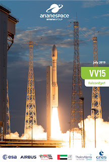
Flight VV15: Mission failure


Arianespace - Vega Flight VV15 Mission poster.

11 July 2019

Arianespace announced today, 11 July, 2019, the failure of Flight VV15 carrying the FalconEye1 satellite. This was the first Vega failure after 14 successful launches in a row since being introduced at the Guiana Space Center in French Guiana in 2012.

VV15 launch pad

The Vega launch vehicle lifted off as scheduled on July 10, 2019 at 10:53 pm (local time in French Guiana). Approximately two minutes after the Vega launcher’s liftoff, shortly after ignition of the second stage (Zefiro 23), a launcher anomaly occurred – leading to the premature end of the mission.

Vega failed launch with FalconEye1

The European Space Agency (ESA) and Arianespace immediately decided to appoint an independent inquiry commission. This commission is tasked with analysing the reasons for the failure and defining the measures needed to ensure the resumption of Vega flights while fulfilling all requisite safety and security conditions. The inquiry commission is co-chaired by the Inspector General of ESA and the Senior Vice President, Technical and Quality of Arianespace.

Preparations for the next Ariane 5 launch are continuing at the Guiana Space Centre, Europe's Spaceport.

Related links:

Vega: http://www.esa.int/Our_Activities/Space_Transportation/Launch_vehicles/Vega

Arianespace: http://www.arianespace.com/

Image, Video, Text, Credits: European Space Agency (ESA)/Arianespace/SciNews.

Greetings, Orbiter.ch

mercredi 10 juillet 2019

Crew Configures Hardware to Monitor Brain and Radiation Exposure in Space


ISS - Expedition 60 Mission patch.

July 10, 2019

The Expedition 60 crew configured a variety of science hardware today monitoring the brain and radiation exposure. The orbital residents also had a steady day of safety gear checks and lab maintenance on the International Space Station.

Astronauts experience blood flow changes caused by living in microgravity that may cause lightheadedness or fainting upon return to Earth. The Cerebral Autoregulation investigation is measuring the waveforms of these blood flows to understand blood pressure regulation in space. Flight Engineer Nick Hague set up the experiment hardware this morning that may help doctors treat and prevent these symptoms.


Image above: The International Space Station was orbiting 258 miles above the Bay of Bengal during an orbital nighttime when this photograph was taken of Earth’s luminous atmospheric glow back-dropped by the tranquil Milky Way. Image Credit: NASA.

Hague next assembled hardware for a high definition camera that will be installed outside the station on an upcoming spacewalk. He and NASA astronaut Christina Koch also installed communication cables and conducted voice checks to support the arrival of future commercial crew vehicles.

International Space Station (ISS)

Radiation exposure is another concern for crewmembers working in space for months or years at a time. Koch handed a set of dosimeters, or radiation detectors, to Commander Alexey Ovchinin during the afternoon for installation on the Russian side of the orbiting lab. Several studies are monitoring neutron radiation and the variation in the radiation environment as the station orbits Earth.

Koch started her morning inspecting breathing masks and fire extinguishers. She checked the emergency equipment for correct pressure measurements and any signs of physical damage on hoses and bottles. Ovchinin continued the replacement of more Russian life support system components during his morning.

Related links:

Expedition 60: https://www.nasa.gov/mission_pages/station/expeditions/expedition60/index.html

Cerebral Autoregulation: https://www.nasa.gov/mission_pages/station/research/experiments/explorer/Investigation.html?#id=1938

Neutron radiation: https://www.nasa.gov/mission_pages/station/research/experiments/explorer/search.html?#q=radi-n&i=&p=&c=&g=&s=

Variation in the radiation environment: https://www.nasa.gov/mission_pages/station/research/experiments/explorer/search.html?#q=matroyshka&i=&p=&c=&g=&s=

Space Station Research and Technology: https://www.nasa.gov/mission_pages/station/research/index.html

International Space Station (ISS): https://www.nasa.gov/mission_pages/station/main/index.html

Images (mentioned), Text, Credits: NASA/Mark Garcia.

Best regards, Orbiter.ch

mardi 9 juillet 2019

NASA Satellites Find Biggest Seaweed Bloom in the World


NASA - EOS Terra Mission patch / NASA - EOS Aqua Mission patch.

July 9, 2019

An unprecedented belt of brown algae stretches from West Africa to the Gulf of Mexico—and it’s likely here to stay. Scientists at the University of South Florida in St. Petersburg's College of Marine Science used NASA satellite observations to discover and document the largest bloom of macroalgae in the world, dubbed the Great Atlantic Sargassum Belt, as reported in Science.

Based on computer simulations, they confirmed that this belt of the brown macroalgae Sargassum forms its shape in response to ocean currents. It can grow so large that it blankets the surface of the tropical Atlantic Ocean from the west coast of Africa to the Gulf of Mexico. In 2018, more than 20 million tons of it – heavier than 200 fully loaded aircraft carriers – floated in surface waters and became a problem to shorelines lining the tropical Atlantic, Caribbean Sea, Gulf of Mexico, and east coast of Florida, as it carpeted popular beach destinations and crowded coastal waters.


Image above: Too much Sargassum can present challenges for marine life and particularly becomes a problem when it collects along coastlines and rots, as shown here in Cancun in 2015. Image Credits: Michael Owen.

“The scale of these blooms is truly enormous, making global satellite imagery a good tool for detecting and tracking their dynamics through time,” said Woody Turner, manager of the Ecological Forecasting Program at NASA Headquarters in Washington.

Chuanmin Hu of the USF College of Marine Science, who led the study, has studied Sargassum using satellites since 2006. Hu spearheaded the work with first author Dr. Mengqiu Wang, a postdoctoral scholar in his Optical Oceanography Lab at USF. The team included others from USF, Florida Atlantic University, and Georgia Institute of Technology. The data they analyzed from NASA’s Moderate Resolution Imaging Spectroradiometer (MODIS) between 2000-2018 indicates a possible regime shift in Sargassum blooms since 2011.

In the satellite imagery, major blooms occurred in every year between 2011 and 2018 except 2013. This information, coupled with field measurements, suggests that no bloom occurred in 2013 because the seed populations of Sargassum measured during winter of 2012 were unusually low, Wang said.


Images above: (Left) An unhealthy amount of Sargassum off Big Pine Key in the lower Florida Keys. Credit: Brian Lapointe, Ph.D., Florida Atlantic University’s Harbor Branch Oceanographic Institute (Right) In patchy doses in the open ocean, Sargassum contributes to ocean health by providing habitat for marine life. Dr. Mengqiu Wang was performing field work in the Gulf of Mexico last year when she saw dolphins seeming to enjoy their foray through the Sargassum. Images Credit: Mengqiu Wang.

Before 2011, most of the free floating Sargassum in the ocean was primarily found in patches around the Gulf of Mexico and Sargasso Sea. The Sargasso Sea is located on the western edge of the central Atlantic Ocean and named after its popular algal resident. In patchy doses in the open ocean, Sargassum contributes to ocean health by providing habitat for turtles, crabs, fish, and birds and, like other plants, producing oxygen via photosynthesis. But too much of this seaweed can crowd out marine species, especially near the coast.

In 2011, Sargassum populations started to explode in places it hadn’t been before, like the central Atlantic Ocean, and then it arrived in gargantuan gobs that suffocated shorelines and introduced a new nuisance for local environments and economies.

“The ocean’s chemistry must have changed in order for the blooms to get so out of hand,” Hu said. Sargassum reproduces from fragments of the parent plant, and it probably has several initiation zones around the Atlantic Ocean. It grows faster when nutrient conditions are favorable, and when its internal clock ticks in favor of reproduction.

The team identified key factors that are critical to bloom formation: a large seed population in the winter left over from a previous bloom, nutrient input from West Africa upwelling in winter, and nutrient input in the spring or summer from the Amazon River. Such discharged nutrients may have increased in recent years due to increased deforestation and fertilizer use, though Hu noted that the evidence for nutrient enrichment is preliminary and based on limited available data, and the team needs more research to confirm this hypothesis. In addition, Sargassum only grows well when salinity is normal and surface temperatures are normal or cooler.


Image above: The Great Atlantic Sargassum Belt in July 2018.Scientists used NASA’s Moderate Resolution Imaging Spectroradiometer (MODIS) on Terra and Aqua satellites to discover the Great Atlantic Sargassum Belt (GASB), which started in 2011. It has occurred every year since, except 2013, and often stretches from the west coast of Africa to the Gulf of Mexico. Image Credits: NASA/Earth Observatory. Data provided by Mengqiu Wang and Chuanmin Hu, USF College of Marine Science.

“Earth’s ocean biogeochemistry is changing in response to natural and human forcings. The Great Atlantic Sargassum Belt suggests that we may be witnessing ecosystem shifts in our ocean that could have important implications for marine organisms and ecosystem services, which humans depend on,” said Dr. Paula Bontempi, who manages NASA’s Ocean Biology and Biogeochemistry Program and serves as acting deputy director of NASA’s Earth Science Division at NASA Headquarters.

"This is all ultimately related to climate change, as climate affects precipitation and ocean circulation and even human activities [that can lead to Sargassum blooms], but what we’ve shown is that these blooms do not occur because of increased water temperature,” Hu said. “They are probably here to stay.”

This work was funded by several programs in NASA’s Earth Science Division, NOAA RESTORE Science Program, the JPSS/NOAA Cal/Val project, the National Science Foundation, and by a William and Elsie Knight Endowed Fellowship.

Related links:

Aqua Satellite: https://www.nasa.gov/mission_pages/aqua/index.html

Terra Satellite: http://www.nasa.gov/mission_pages/terra/index.html

Images (mentioned), Text, Credits: NASA/Sara Blumberg/Earth Science News Team, by Ellen Gray.

Greetings, Orbiter.ch

Not-Unsolved Mysteries: The “Lost” Apollo 11 Tapes


NASA - Apollo 11 patch.

July 9, 2019

With the 50th anniversary of the Apollo 11 moon landing approaching, reports have resurfaced that NASA lost some precious video footage of that first moonwalk.


Image above: Buz Aldrin assembles seismic experiment. Image Credits: NASA/Apollo 11.

Before diving into the details of two distinct events that seem to have become conflated, it’s worth emphasizing three key points:

- NASA searched for but could not locate some of the original Apollo 11 data tapes – “original” in the sense that they directly recorded data transmitted from the Moon. An intensive search of archives and records concluded that the most likely scenario was that the program managers determined there was no longer a need to keep the tapes — since all the video was recorded elsewhere — and they were erased and reused.

- The data on those tapes, including video data, was relayed to the Manned Spacecraft Center (now the Johnson Space Center), during the mission. The video was recorded there and in other locations; there is no missing video footage from the Apollo 11 moonwalk.

- The search discovered high-quality broadcast versions of the footage. NASA worked with Lowry Digital, a premier film restoration company, to process the video using techniques unavailable in 1969. The restored video was released in HD as part of the 40th anniversary of Apollo 11.

Further explanation means diving into the details of how Apollo sent data back to Earth and how NASA collected it.

Data from the Apollo 11 mission was sent from the spacecraft to three ground stations, one in California and two in Australia, which retransmitted it to the Manned Space Flight Center in Houston. The ground stations also recorded the data on special 1-inch, 14-track tapes, one track of which was for video. The video footage was recorded in "slow scan" — 10 video frames per second — which meant it couldn't be directly broadcast over commercial television. The video was converted for broadcast and uplinked to a satellite, then downlinked to Houston, from which it was sent out to the world.

In early 2005, responding to inquiries from NASA retirees and others, NASA began a search for the 14-track data tapes. Ultimately, the agency couldn’t find the tapes and determined that they had most likely been erased and used again, which was standard practice at the time. The search, led by NASA engineer Dick Nafzger, focused on finding the specific tapes, knowing the data had all been recorded and saved elsewhere.

"There was no video that came down slow scan that was not converted live, fed live, to Houston and fed live to the world," Nafzger said at press conference showing some of the restored footage in 2009. "So, just in case anyone thinks there is video out there that hasn’t been seen, that is not the case."

NASA News Briefing on Restored Apollo 11 Moonwalk Video - Clip 1

Video above: July 16, 2009 press conference on the search for and restoration of the Apollo 11 video. Video Credit: NASA.

During the search, though, Nafzger's team came across video that had been converted to broadcast which was much higher quality than what they had been seeing.

“The team of people that I worked with, including myself obviously, was desperate to do something for history, if we could," said Nafzger. "We came across broadcast-converted tapes during this search that were much better than we had seen. . . . We had tapes recorded in Sydney, Australia, during the mission. (We) found kinescopes at the National Archives that had not been viewed in 36 years that were made in Houston. We went to CBS archives and we found tapes that had been fed directly from Houston to CBS . .. . the raw data as recorded and archived.”

NASA News Briefing on Restored Apollo 11 Moonwalk Video - Clip 2

Video above: Working with a California company, NASA restored portions of the video and enhanced it for viewing in high definition and released the HD Apollo 11 videos in July 2009. Video Credit: NASA.

In 2019, a one-time NASA intern is selling what he describes as videotapes of the Apollo 11 moonwalk that he bought at an auction of surplus government goods. If the tapes are as described in the sale material, they are 2-inch videotapes recorded in Houston from the video that had been converted to a format that could be broadcast over commercial television and contain no material that hasn't been preserved at NASA.

Related links:

NASA began a search for the 14-track data tapes: https://www.nasa.gov/mission_pages/apollo/apollo_tapes.html

Press conference showing some of the restored footage in 2009: http://www.youtube.com/watch?v=McyghW9rSIU

HD Apollo 11 videos: https://www.nasa.gov/multimedia/hd/apollo11_hdpage.html

Apollo 11: https://www.nasa.gov/mission_pages/apollo/apollo-11.html

Image (mentioned), Videos (mentioned), Text, Credits: NASA/Brian Dunbar.

Best regards, Orbiter.ch

NASA Maps Surface Changes From California Quakes


ARIA - Advanced Rapid Imaging and Analysis logo.

July 9, 2019


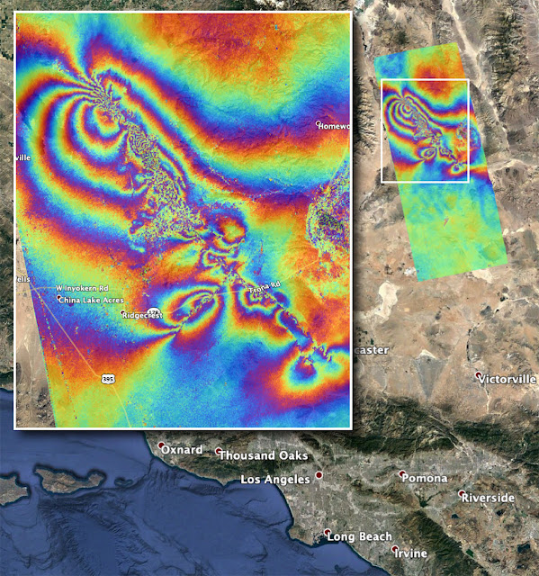
Image above: NASA's Advanced Rapid Imaging and Analysis (ARIA) team created this co-seismic Interferometric Synthetic Aperture Radar (InSAR) map, which shows surface displacement caused by the recent major earthquakes in Southern California, including the magnitude 6.4 and the magnitude 7.1 events on July 4 and July 5, 2019, respectively. Image Credits: NASA/JPL-Caltech.

Damage from two strong earthquakes that rattled Southern California on July 4 and July 5 — a magnitude 6.4 and a magnitude 7.1, respectively — can be seen from space. The epicenter of the quakes was near the city of Ridgecrest, about 150 miles (241 kilometers) northeast of Los Angeles. According to the U.S. Geological Survey, the 7.1 quake was one of the largest to hit the region in some 40 years.

The Advanced Rapid Imaging and Analysis (ARIA) team at NASA's Jet Propulsion Laboratory in Pasadena, California, used synthetic aperture radar (SAR) data from the ALOS-2 satellite to produce a map showing surface displacement from the earthquakes. The post-quake imagery was acquired on July 8, 2019, and compared with April 8, 2018, data from the same region.

Each color cycle represents 4.8 inches (12 centimeters) of ground displacement either toward or away from the satellite. The linear features that cut the color fringes in the southeast indicate likely locations of surface rupture caused by the earthquakes, and the "noisy" areas in the northwest may indicate locations where the ground surface was disturbed by them.

The USGS reported over 1,000 aftershocks in the region following the July 5 earthquake. State and federal scientists, including those from the California Geological Survey and USGS, are using this surface deformation map in the field for assessing the damages and mapping the faults that broke during the two major earthquakes as well as the thousands of aftershocks.

In the aftermath of the earthquakes, NASA's Earth Science Disasters Program is in communication with the California Earthquake Clearinghouse, which is coordinating response efforts with the California Air National Guard, the USGS and the Federal Emergency Management Agency. NASA analysts are using data from satellites to produce visualizations of land deformation and potential landslides, among other earthquake impacts, and are making them available to response agencies. NASA's Disasters Program promotes the use of satellite observations in predicting, preparing for, responding to and recovering from disasters around the world.

The Japanese Aerospace Exploration Agency (JAXA) provided the ALOS-2 data for the production of the map. The ARIA team's analysis was funded by NASA's Disasters Program.

For more information about ARIA, visit: http://aria.jpl.nasa.gov

For more information about NASA's Disasters Program, visit: http://disasters.nasa.gov

ALOS-2: https://directory.eoportal.org/web/eoportal/satellite-missions/a/alos-2

Japanese Aerospace Exploration Agency (JAXA): http://global.jaxa.jp/

Jet Propulsion Laboratory (JPL): https://www.nasa.gov/centers/jpl/home/index.html

Image (mentioned), Text, Credits: NASA/Tony Greicius/JPL/Esprit Smith.

Greetings, Orbiter.ch

lundi 8 juillet 2019

Science Soars to the Space Station on SpaceX CRS-18


SpaceX - Dragon CRS-18 Mission patch.

July 8, 2019

Dozens of scientific experiments are scheduled to travel to the International Space Station aboard a Dragon cargo spacecraft in late July. This 18th SpaceX Commercial Resupply Services (CRS) contract mission for NASA blasts off from Cape Canaveral Air Force Station in Florida on a Falcon 9 rocket. The springboard to NASA's missions to the Moon and Mars, the space station also provides opportunities for other U.S. government agencies, private industry, and academic and research institutions to conduct microgravity research. Such research can lead to the development of new technologies, medical treatments and products that improve life on Earth.

Highlights of Science Launching on SpaceX CRS 18 - July 8, 2019

Read more about some of the scientific investigations traveling to the microgravity laboratory on the Dragon.

These microbes rock


Image above: Sphingomonas desiccabilis, one of three microbes chosen for the BioRock experiment, seen growing on basalt. Run by a research team from the University of Edinburgh in the UK, BioRock tests how altered states of gravity affect biofilm formation on the International Space Station. Image Credits: UK Centre for Astrobiology/University of Edinburgh.

Microbes growing on the surface of rocks can gradually break down those rocks and extract minerals. This natural process enables a process called bio-mining. Common on Earth, bio-mining could eventually help explorers on the Moon or Mars acquire needed materials, lessening the need to use precious resources from Earth and reducing the amount of supplies that explorers must take with them. Microgravity affects the interaction between microbes and rocks, though, and may restrict bacterial growth. The BioRock investigation examines these interactions as well as physical and genetic changes in the microbes. The discoveries could support future acquisition of materials in space and advance development of life support systems with microbial components.

Bioprinting tissues in space


Image above: The Biofabrication Facility created by TechShot, a 3D printer capable of manufacturing human tissue in microgravity. Image Credit: TechShot Inc.

Scientists and medical professionals have long dreamed of using three-dimensional (3D) biological printers to produce usable human organs. But printing the tiny, complex structures found inside human organs, such as capillary structures, has proven difficult in Earth’s gravity. Microgravity eliminates the need for scaffolding structures to support complex tissue shapes, and the BioFabrication Facility (BFF) provides a platform to attempt printing of biological tissues on the space station. This investigation could serve as a first step toward achieving the ability to fabricate entire human organs in space.

How silica rolls in space

Goodyear Tire investigation evaluates the creation of silica fillers using traditional techniques but in microgravity, potentially yielding results not possible on Earth. A better understanding of silica morphology and the relationship between silica structure and its properties could improve the silica design process, silica rubber formulation, and tire manufacturing and performance on the ground. Such improvements could include increased fuel efficiency, which would reduce transportation costs and help to protect Earth’s environment.

Moss grows fat on an orbiting craft

Mosses, tiny plants without roots, need only a small area for growth. These plants show changes in biomass and photosynthesis rate in response to changes in gravity. These traits could prove an advantage for the potential use of mosses as a source of food and oxygen in space and future bases on the Moon or Mars. Space Moss compares mosses grown aboard the space station with those grown on Earth to determine how microgravity affects growth, development, gene expression, photosynthesis, and other features. The investigation also provides a better understanding of the mechanisms of moss response to microgravity, with potential applications for engineering plants to grow better on Earth.

How space gets on our nerves

Space Tango-Induced Pluripotent Stem Cells examines how microglial cells grow and move in 3D cultures and changes in gene expression that occur in microgravity. Microglia are a type of immune defense cell found in the central nervous system. Understanding the way nerve cells grow and survive along with the accompanying changes in gene expression in microgravity is essential to protecting astronaut health, particularly on long-duration missions.

This long-term cell culture investigation is also the first to use human-induced pluripotent stem cells (iPSCs) in microgravity to study Parkinson’s disease and multiple sclerosis. Adult cells genetically programmed to return to an embryonic stem cell–like state, iPSCs potentially could provide an unlimited source of any type of human cell for therapeutic purposes. This research could provide valuable insights into the processes of these diseases and lead to improved prevention and treatments.

Connecting with the space station


Image above: The International Docking Adapter 3 as it is packed into the SpaceX Dragon at Cape Canaveral Air Force Station in Florida on June 19. IDA 3 is intended to support future U.S. crewed vehicles visiting the station. Image Credit: NASA.

International Docking Adapters or IDAs serve as physical points for connecting spacecraft to the space station. Any spacecraft can be designed to use IDAs, from new commercial spacecraft to other yet-to-be designed international vehicles. IDA systems have become more sophisticated than previous docking systems. For example, lasers and sensors allow the station and spacecraft to talk to each other digitally, sharing distance cues and enabling automatic alignment and connection.

IDA 3 attaches to the Harmony node and can accommodate Commercial Crew Program (CCP) vehicle dockings, including the first spacecraft to launch astronauts from U.S. soil since the space shuttle.

Building better bones in space


Image above: Interior view of an incubator cassette from the Bioculture System used by the Cell Science 02 investigation. Image Credits: NASA photo by Dominic Hart.

The Cell Science-02 investigation examines the effects of microgravity on healing and tissue regeneration and on the agents that induce that healing. The investigation improves understanding of how selected growth factors affect tissue regeneration at the molecular and biochemical level and contributes to developing better countermeasures against loss of bone density experienced by astronauts in space. The investigation also has potential applications for those with impaired healing of serious wounds and for treating bone loss due to osteoporosis on Earth.

Related links:

BioRock: https://www.nasa.gov/mission_pages/station/research/experiments/explorer/Investigation.html?#id=7566

BioFabrication Facility (BFF): https://www.nasa.gov/mission_pages/station/research/experiments/explorer/Facility.html?#id=7599

Goodyear Tire: https://www.nasa.gov/mission_pages/station/research/experiments/explorer/Investigation.html?#id=7716

Space Moss: https://www.nasa.gov/mission_pages/station/research/experiments/explorer/Investigation.html?#id=7892

Space Tango-Induced Pluripotent Stem Cells: https://www.nasa.gov/mission_pages/station/research/experiments/explorer/Investigation.html?#id=7976

International Docking Adapters (IDAs): https://www.nasa.gov/feature/meet-the-international-docking-adapter

Cell Science-02: https://www.nasa.gov/mission_pages/station/research/experiments/explorer/Investigation.html?#id=1676

Spot the Station: https://spotthestation.nasa.gov/

Space Station Research and Technology: https://www.nasa.gov/mission_pages/station/research/index.html

International Space Station (ISS): https://www.nasa.gov/mission_pages/station/main/index.html

Images (mentioned), Video (NASA), Text, Credits: NASA/Michael Johnson/JSC/ISSPSO/Melissa Gaskill.

Best regards, Orbiter.ch