samedi 27 décembre 2014

International Launch Services launches ASTRA 2G


ILS - Astra 2G Launch Mission poster.


December27, 2014

Proton-M carrying Astra 2G liftoff

International Launch Services (ILS) has conducted its final launch of the year, with the Russian Proton-M launching the ASTRA 2G satellite from Pad 39 at the Baikonur Cosmodrome in Kazakhstan. Launch is took place at 21:37 GMT on Saturday, ahead of over nine hours of flight to spacecraft separation.

Launch of Russian Proton-M with Astra 2G

The Proton booster is 4.1 m (13.5 ft) in diameter along its second and third stages, with a first stage diameter of 7.4 m (24.3 ft). Overall height of the three stages of the Proton booster is 42.3 m (138.8 ft).

The Proton vehicle has a deep heritage, as it passed the 400 launch mark this year – a total that ranges back to its inception in 1965.

Breeze-M upper-stage ignition

Satellite Use: ASTRA 2G is the third spacecraft of a three satellite investment program (ASTRA 2E, 2F, and 2G) that SES contracted with Airbus Defence and Space in order to provide replacement as well as incremental satellite capacity in the orbital arc of 28.2/28.5 degrees East. ASTRA 2G carries 62 Ku-band transponders as well as 4 Ka-band transponders. The different beams provide wide coverage over the UK and Ireland, Europe and West Africa.

ASTRA 2G satellite

The ASTRA 2G satellite will also support SATMED, an e-health platform conceived by SES and supported by the Luxembourg Government and the Ministry for Cooperation and Humanitarian Action is a satellite based communication solution aimed to improve public health in emerging and developing countries.

For more information about International Launche Services (ILS), visit: http://www.ilslaunch.com/

Images, Video, Text, Credits: ILS / Gunter Soace Page / Orbiter.ch Aerospace.

Best regards, Orbiter.ch

vendredi 26 décembre 2014

A successful launch of the rocket Soyuz-2.1b carrying Resource-P2


ROSCOSMOS logo.

12/26/2014

launch of the rocket Soyuz-2.1b carrying Resource-P2

December 26, 2014 at 21 hours 55 minutes Moscow time from launch pad 31 is made to start the Baikonur Cosmodrome space rocket Soyuz-2.1b with promising Russian spacecraft remote sensing of the Earth Resource-P2.

The launch vehicle and spacecraft removing the calculated orbit passed in a regular mode. Spacecraft adopted by management.

Launch of Russian Soyuz 2.1b rocket carrying Resurs-P2

Carrier rocket Soyuz-2.1b was created in FSUE "GNPRKTs" Samara Space Center "(Samara) and is a modification of Soyuz-2". Compared with the option "1a" it has an engine with high power characteristics at the 3rd stage. The Soyuz-2.1b in relation to the previous version more accurate clearance, stability and control, increased payload mass.

Equipment placed on the SC Resource-P2, allows high resolution imagery of the Earth's surface in the panchromatic and five narrow spectral bands with a ground resolution of - 1.0 and 3.0 - 4.0 meters, respectively, in the band width - 38 km; Shoot with wide-swath - 97 and 441 km and a resolution - 12.0 and 60.0 m in panchromatic band; hyperspectral survey in 96 spectral bands with a resolution of - 25 - 30 m.

Resource-P (Resurs-P) spacecraft

In addition, the SC Resource-P2 installed equipment Automatic Identification (AIS) and scientific equipment "nucleon".

June 25, 2013 in 21 hours 28 minutes Moscow time from the launch complex pl.31 Baikonur Cosmodrome hosted launch vehicle (LV) Soyuz-2.1b with the spacecraft (SC) Resource-P1.

October 1, 2013 on the basis of the results obtained during the flight tests, it was decided according spacecraft Resurs-P with the SC Resource-P1 requirements of tactical and technical tasks and the possibility of transferring it to the nominal operation.

Currently, satellite imagery obtained from the SC Resource-P1, are used to provide a wide range of economic, social and scientific problems in the interests of ministries and agencies, federal and regional authorities of Russia.

As part of the Russian Federal Space Program for the fourth quarter 2015 is scheduled to launch satellites Resource-P3.

ROSCOSMOS Press Release: http://www.federalspace.ru/21218/

Images, Video, Text, Credits: Press Service of the Russian Federal Space Agency / ROSCOSMOS / RIA Novosti / Translation: Orbiter.ch Aerospace.

Greetings, Orbiter.ch

jeudi 25 décembre 2014

Soyuz 2-1B rocket launches from Plesetsk Cosmodrome, Russia


ROSCOSMOS logo.

December 25, 2014


Image above: Soyuz 2-1B rocket carrying Lotos-S reconnaissance satellite on the launch-pad.

December 25 at 6:00 Moscow time on 01 minutes from launch pad 43 state test spaceport of the Ministry of Defence of the Russian Federation (the cosmodrome "Plesetsk") to Start a space rocket "Soyuz-2.1b" with the communication spacecraft. Start calculation made joint experts Russian Ministry of Defense and enterprises of the rocket and space industry.

The launch vehicle and spacecraft removing the calculated orbit passed in a regular mode.

Launches of the rocket middle class "Soyuz-2.1b" carrying military spacecraft

Three minutes after the start of the carrier rocket "Soyuz-2.1b" was taken on the support means ground automated control complex.

In the estimated time the spacecraft was launched into the target orbit and the estimated time (06 pm 16 minutes) adopted by the management of the funds Main Test Space Center. Titov Space Command Forces Aerospace Defence.

Carrier rocket "Soyuz-2.1b" was created in FSUE "GNPRKTs" Samara Space Center "(Samara) and is a modification of Soyuz-2 ". Compared with the option "1a" it has an engine with high power characteristics at the 3rd stage. The "Soyuz-2.1b" in relation to the previous version more accurate clearance, stability and control, increased payload mass.

Lotos-S reconnaissance satellite

Russia's Soyuz 2-1B rocket went into orbit on Thursday morning after a successful launch at 03:01 GMT from the Plesetsk Cosmodrome in Mirny, North Russia. The Soyuz 2-1B’s payload was a Lotos-S reconnaissance satellite - the country's most advanced electronic intelligence satellite. The first-stage separation took 117.5 seconds. The Soyuz 2-1B is 46.1 meters (151 ft) high, has a diameter of 2.95 meters (10 ft) and a launch mass weight of 308,000 kg (679,023 lbs).

ROSCOSMOS Press Release: http://www.federalspace.ru/21215/

Press Service of the Russian Federal Space Agency/ROSCOSMOS/Russian Ministry of Defense/Translation: Orbiter.ch Aerospace.

Greetings, Orbiter.ch

How is Solar Wind Caused? Venus Climate Orbiter "AKATSUKI" Elucidated Solar Wind Acceleration


JAXA - AKATSUKI (PLANET-C) Venus Climate Orbiter logo.

December 25, 2014

Researchers at the Institute of Space and Astronautical Science (ISAS) and the University of Tokyo studied solar wind flowing a long distance from the Sun's vicinity, whose distance is about 20 times the radius of the Sun, and found that the wind drastically accelerated at around a location that is five times the radius away from the Sun. They also clarified that the acceleration of solar wind in such a faraway place was related to heating cause by an energy source of waves transmitting through solar wind.


Image above: A schematic diagram shows the research result summary. We found that the solar wind drastically accelerated around a location that is five times the radius away from the Sun. We also clarified that this acceleration was caused by heat created when sound waves that are generated within the solar wind are destroyed. The blue curvy lines indicate the lines of magnetic force, blue arrows are solar wind speed, and red marks are images of sound waves.

This research result was attained thanks to an onboard instrument of the AKATSUKI, which observes Venus as it travels toward it. The achievement will provide us with a clue to solve the "corona heating issue," which has long been veiled in mystery.

"AKATSUKI" or Planet-C spacecraft

The above research thesis was published in the U.S. magazine "The Astrophysical Journal" in its June 20 and December 10, 2014, issues.

Reference:

Venus Climate Orbiter "AKATSUKI" (PLANET-C): http://global.jaxa.jp/projects/sat/planet_c/

Images, Text, Credits: Japan Aerospace Exploration Agency (JAXA)/The University of Tokyo.

Cheers, Orbiter.ch

Hubble Sees the Beautiful Side of Galaxy IC 335


NASA - Hubble Space Telescope patch.

December 25, 2014


This new NASA/ESA Hubble Space Telescope image shows the galaxy IC 335 in front of a backdrop of distant galaxies. IC 335 is part of a galaxy group containing three other galaxies, and located in the Fornax Galaxy Cluster 60 million light-years away.

As seen in this image, the disk of IC 335 appears edge-on from the vantage point of Earth. This makes it harder for astronomers to classify it, as most of the characteristics of a galaxy’s morphology — the arms of a spiral or the bar across the center — are only visible on its face. Still, the 45 000 light-year-long galaxy could be classified as an S0 type.

These lenticular galaxies are an intermediate state in galaxy morphological classification schemes between true spiral and elliptical galaxies. They have a thin stellar disk and a bulge, like spiral galaxies, but in contrast to typical spiral galaxies they have used up most of the interstellar medium. Only a few new stars can be created out of the material that is left and the star formation rate is very low. Hence, the population of stars in S0 galaxies consists mainly of aging stars, very similar to the star population in elliptical galaxies.

Hubble orbiting Earth

As S0 galaxies have only ill-defined spiral arms they are easily mistaken for elliptical galaxies if they are seen inclined face-on or edge-on as IC 335 here. And indeed, despite the morphological differences between S0 and elliptical class galaxies, they share some common characteristics, like typical sizes and spectral features.

Both classes are also deemed "early-type" galaxies, because they are evolving passively. However, while elliptical galaxies may be passively evolving when we observe them, they have usually had violent interactions with other galaxies in their past.  In contrast,  S0 galaxies are either aging and fading spiral galaxies, which never had any interactions with other galaxies, or they are the aging result of a single merger between two spiral galaxies in the past. The exact nature of these galaxies is still a matter of debate.

For more informations and images of Hubble Space Telescope, visit: http://hubblesite.org/ and http://www.spacetelescope.org/

Image, Video, Text, Credits: ESA/Hubble and NASA.

Cheers, Orbiter.ch

"IBUKI" (GOSAT) Satellite's Historically Unprecedented Observation of Anthropogenic CO2 Emissions


JAXA - IBUKI (GOSAT) Mission logo.

December 25, 2014

"IBUKI" (GOSAT) Satellite's Historically Unprecedented Observation of Anthropogenic CO2 Emissions of Mega-City Regions from Space

The Greenhouse gases Observing SATellite "IBUKI", developed jointly by the Ministry of the Environment (MOE), the National Institute for Environmental Studies (NIES), and the Japan Aerospace Exploration Agency (JAXA) is the world's only satellite designed specifically to monitor greenhouse gases from space. The satellite has continued to fulfill its main mission in monitoring atmospheric carbon dioxide (CO2) and methane concentrations from space to improve the accuracy of sink/source estimates, and achieve its target to contribute to precision refinement for the ongoing elucidation of carbon cycles, since its launch on January 23, 2009.

CO2 concentrations in mega-cities and their surroundings were analyzed for the three and half years from June 2009 to December 2012, based on the observational data acquired by "IBUKI", indicating the tendency for higher CO2 concentrations in mega-cities than those in their surroundings. Furthermore, positive correlations were shown between differences in CO2 concentrations and the concentrations estimated from data for fossil fuel consumption. These results indicate that "IBUKI" observations have the potential to enable us to detect enhanced CO2 concentrations with their origin in fossil fuel consumption for mega-cities. These studies demonstrate the potential utility of satellite observation of CO2 concentrations as a tool for monitoring greenhouse gas emissions (inventory) from fossil fuels.

With the progress in studies to monitor large point CO2 sources by satellite observation and other methods, these results will be applied to current and forthcoming research projects involving "IBUKI" and its successor - GOSAT-2 - to be launched in fiscal year 2017.

1. Overview of the data on anthropogenic CO2 concentrations from "IBUKI" (GOSAT)

Carbon dioxide (CO2) is a greenhouse gas the atmospheric concentration of which has increased by 40% when compared to pre-industrial times, as a result of anthropogenic activities. Fossil fuel consumption in large fossil fuel power plants and mega-cities are assumed to be the main sources of anthropogenic CO2 emissions. The CO2 emission rates in these areas should be accurately evaluated to monitor greenhouse gas emissions.

A validation study has shown that the greenhouse gases observation sensor, "TANSO-FTS" onboard "IBUKI" observes column-averaged CO2 concentrations (hereinafter, "CO2 concentrations") to a precision (random error) of 0.5% (approximately 2 ppm) in comparison to the data acquired from ground-based observations. This study investigated the detectability of enhanced CO2 concentrations due to anthropogenic emissions, by satellite observation.

CO2 concentrations acquired by "IBUKI" comprise not only those pertaining to anthropogenic emissions but also encompass photosynthetic uptake and respiration-release by plants; emissions due to forest fires; and sink/source by ocean. These processes should be considered when interpreting the information on anthropogenic CO2 emissions from the CO2 concentrations acquired by "IBUKI". This study estimated CO2 concentrations due to anthropogenic activities from observational data by "IBUKI" by the method described below.

Firstly, the spatiotemporal distribution of CO2 concentrations originating from anthropogenic CO2 emissions are estimated using the data for anthropogenic CO2 emission rates from fossil fuel consumption (emission inventory) - a value based on the data for nighttime lights on the earth's surface as observed by satellite, as well as the information from the database for fossil fuel power plants and an atmospheric tracer transport model. Subsequently, on the basis of this estimate, the observational data for CO2 concentrations acquired by "IBUKI" are classified into two categories: data including contamination by anthropogenic CO2 emissions (top panel in Figure 1) and those not including this contamination. The individual observational data sets including anthropogenic contamination are subtracted using averaged values for the data not including contamination, and values for CO2 concentrations from forest fires and plant activities are then subtracted from the data. These calculations produce the figures for anthropogenic CO2 concentrations using observational data from "IBUKI" (bottom panel in Figure 1).

2. Results of anthropogenic CO2 concentration estimates from "IBUKI"

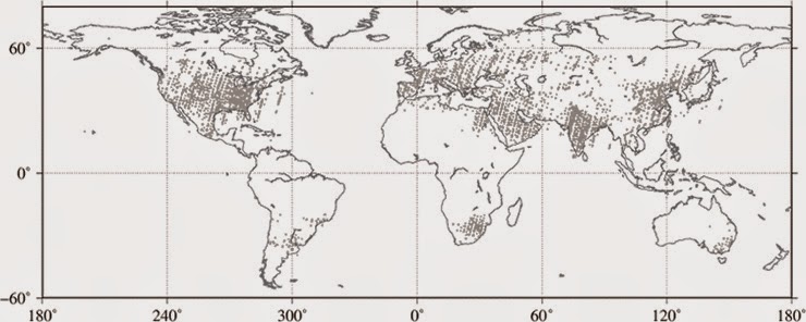
Figure 1 shows global distribution of anthropogenic CO2 concentrations estimated from observational data from "IBUKI". Data including contamination by anthropogenic CO2 emissions is mainly concentrated on the Northern Hemisphere, especially in mega-city regions (top panel in Figure 1).

Figure 1

Graphics above: (Top) Observational points of "IBUKI" where anthropogenic CO2 concentrations are higher than 0.1 ppm for June 2009 and December 2012.

(Bottom) Distribution of anthropogenic CO2 concentrations estimated from observational data acquired by "IBUKI".

(1 deg. grid resolution; only grid with observational data greater than 24 are plotted).

Anthropogenic CO2 concentrations are shown by colors. Red rectangles show the areas listed in Table 1. Three of four regions used in Figure 3 are shown in yellow, green, and blue for, respectively, Japan, East Asia, and North America.

 Figure 2

Graphics above: Enlarged views of North America (top) and East Asia (bottom) in Figure 1.

Table 1 A list of regions indicating high concentrations of anthropogenic CO2 emissions derived from "IBUKI" in Figure 1.


* Average figure of anthropogenic CO2 concentration of Japan (scope within yellow pengtagon in the bottom part of figure 1) for past 3.5 years is 0.2ppm.

Regions with higher CO2 concentrations from anthropogenic activities are shown in the bottom of Figure 1 and Figure 2 and summarized in Table 1. The regions in Table 1 can be identified as those with dense populations or industrial zones with fossil fuel power plants and developments of oil and gas fields.

Figure 3 shows the relationships between anthropogenic CO2 concentrations derived from the emission inventory and the observational data acquired by "IBUKI" in four regions (Japan, East Asia, North America, and the globe), as shown in the bottom of Figure 1. Key aspects relating to Figure 3 are as follows:

1. Anthropogenic CO2 concentrations derived from the emission inventory and the observational data acquired by "IBUKI" show high correlations in "globe" and "North America"; and the differences in concentration measurements fall within the range of observational error for "IBUKI".

2. Good correlations are also found in the concentrations for "East Asia"; however differences exceed the range of observational error for "IBUKI" for some measurements.

3. While there is a correlation between the concentrations for "Japan", estimation errors for anthropogenic CO2 concentrations from "IBUKI" are significant due to a paucity of observational data.

These results suggest that "IBUKI" has the potential to detect enhanced CO2 concentrations resulting from fossil fuel consumption in mega-cities.

Figure 3

Graphic above: Relationships for anthropogenic CO2 concentrations derived from emission inventory and "IBUKI" for the globe (left), North America and East Asia (center), and Japan (right). Anthropogenic CO2 concentrations derived from "IBUKI" were classified for each 0.2 ppm of concentrations from inventory; average and standard deviation was then calculated in each class. This study excluded data with concentrations from inventory greater than 1 ppm.

Notes:

1. Column-averaged concentration of CO2

The mixing ratio of CO2 molecules relative to that of dry air, from the earth's surface to the upper extremities of the atmosphere.

2. Anthropogenic CO2 concentrations estimated from inventory

Inventories of CO2 emissions from fossil fuel consumption and forest fires, a biospheric model, and an atmospheric tracer transport model were used in this study to estimate anthropogenic CO2 concentrations by inventory.

3. Inventory of CO2 emissions by fossil fuel consumption

ODIAC (Open-sources Data Inventory for Anthropogenic CO2) was used in this study as inventory for CO2 emissions by fossil fuel consumption. Oda and Maksyutov, Atmos. Chem. Phys., 11, 543-556, 2011.

4. Database of fossil fuel power plants

CARMA (Carbon Monitoring for Actions) is used in ODIAC as the database for fossil fuel power plants: http://www.carma.org/plant

5. Inventory of CO2 emissions by forest fires

GFAS (Global Fire Assimilation System) was used in this study as inventory for CO2 emissions by forest fires. Kaiser et al., Biogeosciences, 9, 527-554, 2011.

Reference:

Greenhouse gases Observing SATellite "IBUKI" (GOSAT): http://global.jaxa.jp/projects/sat/gosat/

Images, Graphics, Text, Credits: Japan Aerospace Exploration Agency (JAXA)/National Institute for Environmental Studies (NIES)/Ministry of the Environment, Japan (MOE).

Greetings, Orbiter.ch

mardi 23 décembre 2014

Station Decorated for Holidays as Crew Studies Life in Space


ISS - Expedition 42 Mission patch.

December 23, 2014

It’s beginning to look like Christmas on the International Space Station. The stockings are out, the tree is up and the station residents continue advanced space research to benefit life on Earth and in space.

Space Station Crew Members Offer Christmas Greetings to the World

A wide array of research work took place Tuesday with scientists on the ground, working in conjunction with the astronaut lab assistants, exploring different fields.


Image above: Italian astronaut Samantha Cristoforetti is in the holiday spirit as the station is decorated with stockings for each crew member and a tree. Image Credit: NASA TV.

Behavioral testing was scheduled Tuesday for the Neuromapping study to assess changes in a crew member’s perception, motor control, memory and attention during a six-month space mission. Results will help physicians understand brain structure and function changes in space, how a crew member adapts to returning to Earth and develop effective countermeasures.

Read more about NeuroMapping: http://www.nasa.gov/mission_pages/station/research/experiments/1007.html

Another study is observing why human skin ages at a quicker rate in space than on Earth. The Skin B experiment will provide scientists a model to study the aging of other human organs and help future crew members prepare for long-term missions beyond low-Earth orbit.

Read more about Skin-B: http://www.nasa.gov/mission_pages/station/research/experiments/1166.html


Image above: Italian astronaut Samantha Cristoforetti works in the Materials Science Laboratory. Credit: NASA TV.

The six Expedition 42 crew members started Christmas week with a replanned schedule after SpaceX postponed its Dragon launch until Jan. 6. The crew would have been unloading new science and cargo from Dragon had it arrived Sunday but instead turned its attention to ongoing science and maintenance.

Commander Barry Wilmore worked on the Binary Colloidal Alloy Test experiment that will help scientists design higher quality consumer products that will last longer. Wilmore also joined NASA astronaut Terry Virts for an interview with CBS Morning News and WBAL Radio in Baltimore, Md.


Image above: Commander Barry Wilmore gives Flight Engineer Terry Virts a haircut using a razor that also vacuums the hair that is cut. Image Credit: NASA TV.

Virts meanwhile continued preparing for the arrival of Dragon as he collected gear to be stowed on the commercial cargo craft for return to Earth. He also packed trash in Europe’s Automated Transfer Vehicle, which will undock in February for a fiery destruction over the Pacific Ocean.

Italian astronaut Samantha Cristoforetti spent a few minutes Monday talking to Giorgio Napolitano, the president of Italy, who was addressing the nation’s military forces. Later, Samantha collected biological samples for stowage in a science freezer and worked inside the Materials Science Laboratory.

For more information about the International Space Station (ISS), visit: http://www.nasa.gov/mission_pages/station/main/index.html

Images (mentioned), Video, Text, Credit: NASA / NASA TV.

Best regards, Orbiter.ch

Frosty Slopes on Mars


NASA - Mars Reconnaissance Orbiter (MRO) patch.


This image of an area on the surface of Mars, approximately 1.5 by 3 kilometers in size, shows frosted gullies on a south-facing slope within a crater.

At this time of year, only south-facing slopes retain the frost, while the north-facing slopes have melted. Gullies are not the only active geologic process going on here. A small crater is visible at the bottom of the slope.

The image was acquired on Nov. 30, 2014, by the High Resolution Imaging Science Experiment (HiRISE) camera, one of six instruments on NASA's Mars Reconnaissance Orbiter. The University of Arizona, Tucson, operates HiRISE, which was built by Ball Aerospace & Technologies Corp., Boulder, Colorado. NASA's Jet Propulsion Laboratory, a division of the California Institute of Technology in Pasadena, manages the Mars Reconnaissance Orbiter Project for NASA's Science Mission Directorate, Washington.

More information and image products: http://www.uahirise.org/ESP_039114_1115

More information about Mars Reconnaissance Orbiter (MRO), visit: http://mars.jpl.nasa.gov/mro/

Image, Text, Credits: NASA/JPL-Caltech/University of Arizona/Caption: Livio Tornabene, Ryan Hopkins, Kayle Hansen and Eric Pilles.

Greetings, Orbiter.ch

Sun Sizzles in High-Energy X-Rays


NASA - NuStar Mission patch.

December 23, 2014

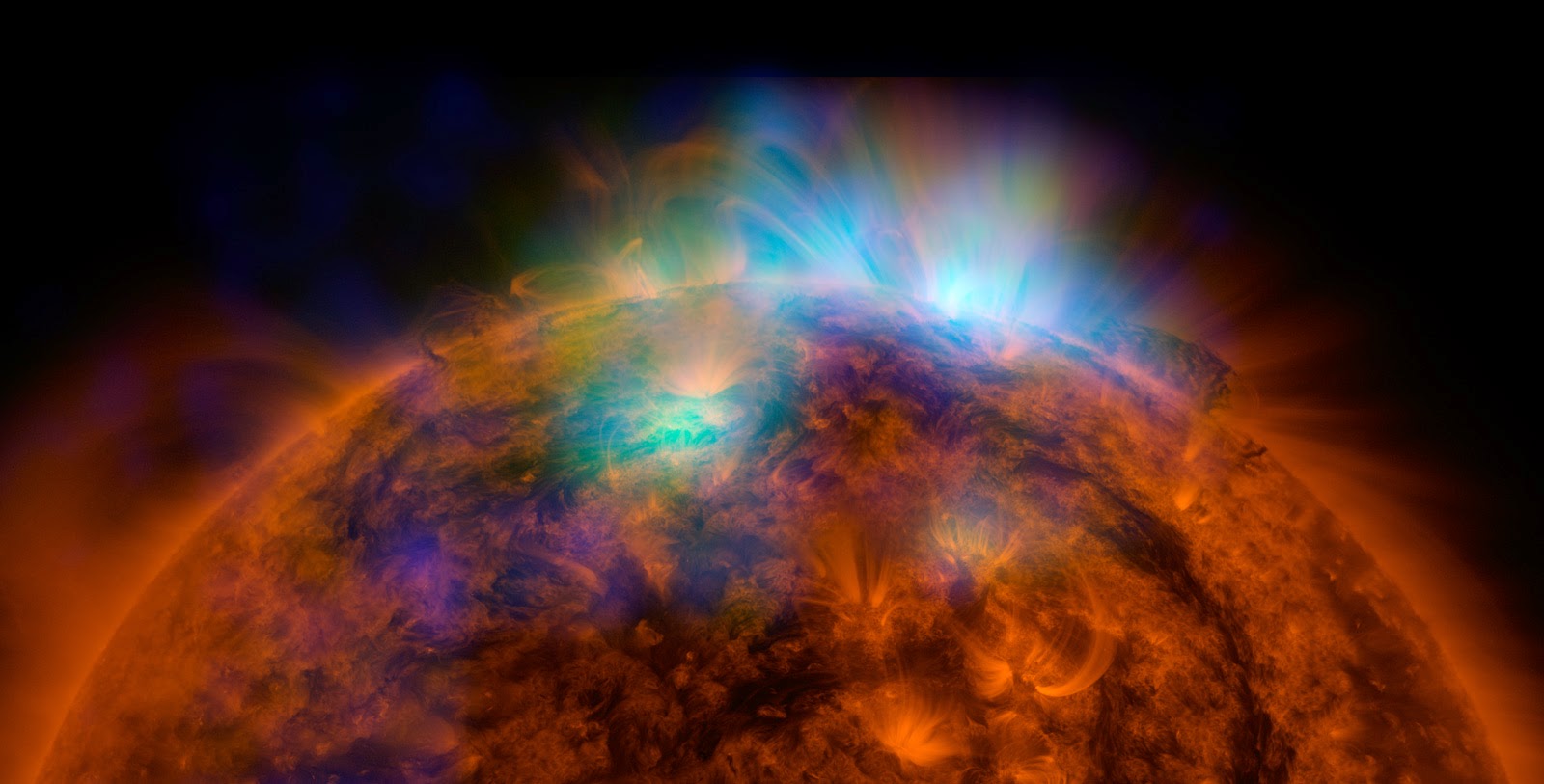
For the first time, a mission designed to set its eyes on black holes and other objects far from our solar system has turned its gaze back closer to home, capturing images of our sun. NASA's Nuclear Spectroscopic Telescope Array, or NuSTAR, has taken its first picture of the sun, producing the most sensitive solar portrait ever taken in high-energy X-rays.


Image above: X-rays stream off the sun in this image showing observations from by NASA's Nuclear Spectroscopic Telescope Array, or NuSTAR, overlaid on a picture taken by NASA's Solar Dynamics Observatory (SDO).Image credit: NASA/JPL-Caltech/GSFC.

"NuSTAR will give us a unique look at the sun, from the deepest to the highest parts of its atmosphere," said David Smith, a solar physicist and member of the NuSTAR team at University of California, Santa Cruz.

Solar scientists first thought of using NuSTAR to study the sun about seven years ago, after the space telescope's design and construction was already underway (the telescope launched into space in 2012). Smith had contacted the principal investigator, Fiona Harrison of the California Institute of Technology in Pasadena, who mulled it over and became excited by the idea.

"At first I thought the whole idea was crazy," says Harrison. "Why would we have the most sensitive high energy X-ray telescope ever built, designed to peer deep into the universe, look at something in our own back yard?" Smith eventually convinced Harrison, explaining that faint X-ray flashes predicted by theorists could only be seen by NuSTAR.

While the sun is too bright for other telescopes such as NASA's Chandra X-ray Observatory, NuSTAR can safely look at it without the risk of damaging its detectors. The sun is not as bright in the higher-energy X-rays detected by NuSTAR, a factor that depends on the temperature of the sun's atmosphere.

This first solar image from NuSTAR demonstrates that the telescope can in fact gather data about sun. And it gives insight into questions about the remarkably high temperatures that are found above sunspots -- cool, dark patches on the sun. Future images will provide even better data as the sun winds down in its solar cycle.

"We will come into our own when the sun gets quiet," said Smith, explaining that the sun's activity will dwindle over the next few years.

NASA's Nuclear Spectroscopic Telescope Array, or NuSTAR. Image Credits:NASA/JPL-Caltech
 
With NuSTAR's high-energy views, it has the potential to capture hypothesized nanoflares -- smaller versions of the sun's giant flares that erupt with charged particles and high-energy radiation. Nanoflares, should they exist, may explain why the sun's outer atmosphere, called the corona, is sizzling hot, a mystery called the "coronal heating problem." The corona is, on average, 1.8 million degrees Fahrenheit (1 million degrees Celsius), while the surface of the sun is relatively cooler at 10,800 Fahrenheit (6,000 degrees Celsius). It is like a flame coming out of an ice cube. Nanoflares, in combination with flares, may be sources of the intense heat.

If NuSTAR can catch nanoflares in action, it may help solve this decades-old puzzle.

"NuSTAR will be exquisitely sensitive to the faintest X-ray activity happening in the solar atmosphere, and that includes possible nanoflares," said Smith.

What's more, the X-ray observatory can search for hypothesized dark matter particles called axions. Dark matter is five times more abundant than regular matter in the universe. Everyday matter familiar to us, for example in tables and chairs, planets and stars, is only a sliver of what's out there. While dark matter has been indirectly detected through its gravitational pull, its composition remains unknown.

It's a long shot, say scientists, but NuSTAR may be able spot axions, one of the leading candidates for dark matter, should they exist. The axions would appear as a spot of X-rays in the center of the sun.

Meanwhile, as the sun awaits future NuSTAR observations, the telescope is continuing with its galactic pursuits, probing black holes, supernova remnants and other extreme objects beyond our solar system.

NuSTAR is a Small Explorer mission led by Caltech and managed by NASA's Jet Propulsion Laboratory, also in Pasadena, for NASA's Science Mission Directorate in Washington. The spacecraft was built by Orbital Sciences Corporation, Dulles, Virginia. Its instrument was built by a consortium including Caltech; JPL; the University of California, Berkeley; Columbia University, New York; NASA's Goddard Space Flight Center, Greenbelt, Maryland; the Danish Technical University in Denmark; Lawrence Livermore National Laboratory, Livermore, California; ATK Aerospace Systems, Goleta, California; and with support from the Italian Space Agency (ASI) Science Data Center.

NuSTAR's mission operations center is at UC Berkeley, with the ASI providing its equatorial ground station located at Malindi, Kenya. The mission's outreach program is based at Sonoma State University, Rohnert Park, California. NASA's Explorer Program is managed by Goddard. JPL is managed by Caltech for NASA.

For more information, visit: http://www.nasa.gov/nustar and http://www.nustar.caltech.edu

Images (mentioned), Text, Credits: NASA/JPL/Whitney Clavin.

Cheers, Orbiter.ch

The first launch of the heavy rocket class Angara-A5


ROSCOSMOS patch.

23.12.2014

Angara-A5 liftoff!

December 23, 2014 at 08:57 Moscow time (05:57 UTC), the first test launch of the carrier rocket Angara-A5 heavy class from the cosmodrome Plesetsk. "This means that Russia will have a new, modern and environmentally friendly medium heavy class", - said the head of Roscosmos Oleg Ostapenko.

Video of the launch of the heavy rocket class Angara-A5

Creating a space rocket complex "Angara" is one of the priorities of the national launch vehicle system entirely based on the use of Russian scientific and industrial potential.

 The first Angara-A5 rocket sits on its launch pad at the Plesetsk Cosmodrome in northern Russia

The family of rockets Angara includes light, medium and heavy classes to carrier a payload of 3.8 to 35 tons. The lead developer and manufacturer of Booster is a Federal State Unitary Enterprise "State Research and Production Space Center Khrunichev." "I congratulate all those who were involved in this launch and establishment of the missile - designers, engineers, workers, and the military. Thank you for your selfless work"- added O.N.Ostapenko.

Angara rockets family (Angara-1, Angara-3, Angara-5)

Work on the creation of land-based infrastructure preparation and launch vehicle "Angara" conducted under the Federal Space Program, as well as the "Strategy of innovative development of Russia until 2020" and "Principles of State Policy of the Russian Federation in the field of space activities for the period up to 2030 and Beyond ", approved by the President of the Russian Federation on April 19, 2013 № Pr-906.

The Angara A5 rocket

The Angara A5, use one URM-1 core and four URM-1 boosters, the enlarged 3.6m URM-2 second stage, and an upper stage, either the Briz-M or the KVTK Weighing 773 tonnes at lift-off, Angara A5 have a payload capacity of 35 tonnes to a 200 km x 60° orbit. Angara A5 be able to deliver 5.4 tonnes to GTO with Briz-M, or 7.5 tonnes to the same orbit with KVTK.

Angara A5 roll out to the launch-pad

In the Angara A5, the four URM-1s used as boosters operate at full thrust for approximately 214 seconds, then separate. The URM-1 forming the vehicle's core is operated at full thrust for lift off, then throttled down to 30% to conserve propellant. The core is throttled back up after the boosters have separated and continues burning for another 110 seconds.

ROSCOSMOS Press Release: http://www.federalspace.ru/21211/

Images, Video, Text, Credits: Press Service of the Russian Federal Space Agency/ROSCOSMOS/Russian Ministry of Defense/Orbiter.ch Aerospace.

Greetings, Orbiter.ch

lundi 22 décembre 2014

The worst trip around the world


ISS - International Space Station logo.

22 December 2014

As you celebrate the end of the year in the warmth of your home, spare a thought for the organisms riding with a third-class ticket on the International Space Station – bolted to the outside with no protection against open space.

Flying third class

As part of ESA’s Expose-R2 project, 46 species of bacteria, fungi and arthropods were delivered by a Progress supply ship to the Station in July. Spacewalking cosmonauts Alexander Skvortsov and Oleg Artemyev attached the package to the outside of the Zvezda module on 18 August, where it will stay for 18 months.

Freeze-dry, warm, repeat

The vacuum of space is sucking out the water, oxygen and other gases in the samples. Their temperature can drop to –12°C as the Station passes through Earth’s shadow, rising to 40°C at other times, and undergoing a similar process to the freeze-drying used to preserve foods.

Expose-R2

The Expose experiments are exploring the limits of terrestrial life, whether the organisms can survive in space and how the full blast of solar radiation is affecting accompanying chemicals.

Earth is protected from the Sun’s full radiation by our atmosphere filtering out the hard-hitting short wavelengths that are damaging to life. It is difficult to recreate on the ground the full spectrum of the Sun’s light so these experiments in space are the only way to test how biological and material samples behave in conditions beyond Earth.

Installing Expose-R2

ESA has a long history of testing organisms and organic chemicals in the harsh environment of space. Previous experiments revealed that lichens and water bears can survive spaceflight unprotected, hinting at the possibility of species colonising planets via meteoroids.

Bringing Mars closer to Earth

Not every sample is suffering the same level of discomfort on its epic ride in space. Expose has special compartments that recreate the martian atmosphere by filtering some sunlight and retaining some pressure.

An impressive view

René Demets, ESA’s project scientist for Expose, explains: “The martian sections allow us to investigate to what extent terrestrial life can cope with the extreme conditions on the Red Planet. We hope they will contribute to the discussion about the possibility of life on Mars.”

All the samples are stored in duplicate or even triplicate to strengthen the scientific results when the three trays are returned to Earth in early 2016 for analysis.

Who knows what we will find or even if any of the organisms will have survived possibly the worst voyage around the world.

Related Links:

First results from Expose-E Mission reported in Astrobiology Journal: http://www.liebertpub.com/global/pressrelease/first-results-of-deep-space-experiments-from-expose-e-mission-reported-in-astrobiology-journal/1057/

Read the Astrobiology Journal special collection on Expose-E: http://online.liebertpub.com/toc/ast/12/5

Experiment archive: http://eea.spaceflight.esa.int/

Images, Text, Credits: ESA/Roscosmos.

Best regards, Orbiter.ch

Holiday Lights on the Sun: Imagery of a Solar Flare


NASA - Solar Dynamics Observatory (SDO) patch.

December 22, 2014


The sun emitted a significant solar flare, peaking at 7:28 p.m. EST on Dec. 19, 2014. NASA’s Solar Dynamics Observatory, which watches the sun constantly, captured an image of the event.

Solar flares are powerful bursts of radiation. Harmful radiation from a flare cannot pass through Earth's atmosphere to physically affect humans on the ground, however -- when intense enough -- they can disturb the atmosphere in the layer where GPS and communications signals travel. This flare is classified as an X1.8-class flare.

Holiday Lights on the Sun

X-class denotes the most intense flares, while the number provides more information about its strength. An X2 is twice as intense as an X1, an X3 is three times as intense, etc.

For more information about Solar Dynamics Observatory (SDO), visit: http://www.nasa.gov/mission_pages/sdo/main/

Image, Video, Text, Credits: NASA/SDO.

Greetings, Orbiter.ch