mardi 25 mars 2014

Expedition39/40 Trio Launches to Complete ISS Crew


ROSCOSMOS - Soyuz TMA-12M Mission patch.

March 25, 2014


Image above: Liftoff of Soyuz TMA-12M with 3 new crewmembers for ISS. Image Credit: NASA TV / Screen capture: Orbiter.ch Aerospace.

A new trio of Expedition 39 crewmembers has departed for the International Space Station, launching at 5:17 p.m. EDT from the Baikonur Cosmodrome, Kazakhstan. They will arrive less than six hours later for a docking to the Poisk module at 11:04 p.m.

Launch of Manned Expedition 39 in Soyuz TMA-12M

Soyuz Commander Alexander Skvortsov and Flight Engineer Oleg Artemyev of the Russian Federal Space Agency (Roscosmos) and Flight Engineer Steve Swanson of NASA are riding inside the Soyuz TMA-12M spacecraft. They will orbit the Earth four times before they rendezvous and approach the orbital laboratory.

Watch Docking Live on NASA TV at 10:30 p.m. EDT: http://www.nasa.gov/multimedia/nasatv

After docking, they will go through a series of leak and pressure checks between the two spacecraft before finally opening the hatches to the station almost two hours later. The trio will enter into the Poisk module and greet Expedition 39 Commander Koichi Wakata of the Japan Aerospace Exploration Agency and Flight Engineers Rick Mastracchio of NASA and Mikhail Tyurin of Roscosmos.


Image above: Expedition 39 crew members give a thumbs during a press conference at the Cosmonaut Hotel in Baikonur, Kazakhstan. Image Credit: ROSCOSMOS.

After a welcoming ceremony and congratulatory words with family, friends and mission officials, the new orbiting sextet will conduct a mandatory safety orientation. All six crew members then will have an off-duty day Wednesday as they relax having shifted their schedules to accommodate the busy launch and docking activities.

As is customary, Swanson, Skvortsov and Artemyev will have several days set aside to familiarize themselves with their new home in space. The new trio will also assist the veteran crewmates as they adjust to living and working in space for six months.


Image above: The gantry arms begin to close around the Soyuz TMA-12M spacecraft to secure the rocket Image Credit: NASA/Bill Ingalls.

Swanson, Skvortsov and Artemyev are scheduled to return home in September as Expedition 40 crew members. They will officially become Expedition 40 when Expedition 39 crew members Wakata, Mastracchio and Tyurin end their mission and undock in their Soyuz TMA-11M spacecraft in May for their return to Earth.

For more information about the International Space Station (ISS), visit: http://www.nasa.gov/mission_pages/station/main/index.html

Images (mentioned), Video, Text, Credits: NASA / ROSCOSMOS TV / NASA TV.

Best regards, Orbiter.ch

First Images Available from NASA-JAXA Global Rain and Snowfall Satellite


NASA / JAXA - Global Precipitation Measurement (GPM) patch.

March 25, 2014

GPM's Stormy New View

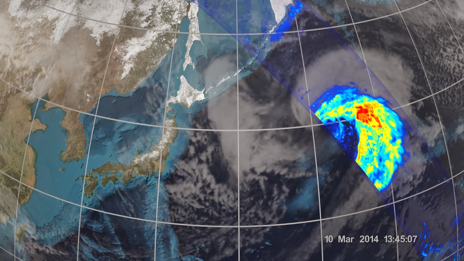
Video above: On March 10, the Core Observatory passed over an extra-tropical cyclone about 1,055 miles (1,700 kilometers) due east of Japan's Honshu Island. Satellite data shows the full range of precipitation in the storm. Video Credit: NASA's Goddard Space Flight Center.

NASA and the Japan Aerospace Exploration Agency (JAXA) have released the first images captured by their newest Earth-observing satellite, the Global Precipitation Measurement (GPM) Core Observatory, which launched into space Feb. 27.

The images show precipitation falling inside a March 10 cyclone over the northwest Pacific Ocean, approximately 1,000 miles east of Japan. The data were collected by the GPM Core Observatory's two instruments: JAXA's Dual-frequency Precipitation Radar (DPR), which imaged a three-dimensional cross-section of the storm; and, NASA's GPM Microwave Imager (GMI), which observed precipitation across a broad swath.

"It was really exciting to see this high-quality GPM data for the first time," said GPM project scientist Gail Skofronick-Jackson at NASA's Goddard Spaceflight Center in Greenbelt, Md. "I knew we had entered a new era in measuring precipitation from space. We now can measure global precipitation of all types, from light drizzle to heavy downpours to falling snow."


Image above: An extra-tropical cyclone seen off the coast of Japan, March 10, 2014, by the GPM Microwave Imager. The colors show the rain rate: red areas indicate heavy rainfall, while yellow and blue indicate less intense rainfall. The upper left blue areas indicate falling snow. Image Credit:
NASA/JAXA.

The satellite's capabilities are apparent in the first images of the cyclone. Cyclones such as the one imaged -- an extra-tropical cyclone -- occur when masses of warm air collide with masses of cold air north or south of the tropics. These storm systems can produce rain, snow, ice, high winds, and other severe weather. In these first images, the warm front ahead of the cyclone shows a broad area of precipitation -- in this case, rain -- with a narrower band of precipitation associated with the cold front trailing to the southwest. Snow is seen falling in the northern reaches of the storm.

The GMI instrument has 13 channels that measure natural energy radiated by Earth's surface and also by precipitation itself. Liquid raindrops and ice particles affect the microwave energy differently, so each channel is sensitive to a different precipitation type. With the addition of four new channels, the GPM Core Observatory is the first spacecraft designed to detect light rain and snowfall from space.

In addition to seeing all types of rain, GMI's technological advancements allow the instrument to identify rain structures as small as about 3 to 9 miles (5 to 15 kilometers) across. This higher resolution is a significant improvement over the capability of an earlier instrument flown on the Tropical Rainfall Measurement Mission in 1997.


Image above: On March 10 the Core Observatory passed over an extra-tropical cyclone about 1,055 miles (1,700 km) east of Japan's Honshu Island. Formed when a cold air mass wrapped around a warm air mass near Okinawa on March 8, it moved NE drawing cold air over Japan before weakening over the North Pacific. Image Credit: NASA/JAXA.

"You can clearly see them in the GMI data because the resolution is that much better," said Skofronick-Jackson.

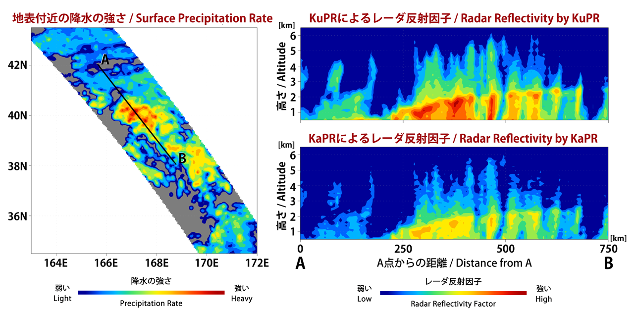
The DPR instrument adds another dimension to the observations that puts the data into high relief. The radar sends signals that bounce off the raindrops and snowflakes to reveal the 3D structure of the entire storm. Like GMI, its two frequencies are sensitive to different rain and snow particle sizes. One frequency senses heavy and moderate rain. A new, second radar frequency is sensitive to lighter rainfall and snowfall.

"Both return independent measurements of the size of raindrops or snowflakes and how they are distributed within the weather system," said DPR scientist Bob Meneghini at Goddard. "DPR allows scientists to see at what height different types of rain and snow or a mixture occur -- details that show what is happening inside sometimes complicated storm systems."


Image above: The GMI instrument has 13 channels, each sensitive to different types of precipitation. Channels for heavy rain, mixed rain and snow, and snowfall are displayed of the extra-tropical cyclone observed March 10, off the coast of Japan. Multiple channels capture the full range of precipitation. Image Credit: NASA/JAXA.

The DPR data, combined with data from GMI, also contribute to more accurate rain estimates. Scientists use the data from both instruments to calculate the rain rate, which is how much rain or snow falls to Earth. Rain rate is one of the Core Observatory's essential measurements for understanding where water is on Earth and where it's going.

"All this new information comes together to help us better understand how fresh water moves through Earth's system and contributes to things like floods and droughts," said Skofronick-Jackson.


Image above: 3D view inside an extra-tropical cyclone observed off the coast of Japan, March 10, 2014, by GPM's Dual-frequency Precipitation Radar. The vertical cross-section approx. 4.4 mi (7 km) high show rain rates: red areas indicate heavy rainfall while yellow and blue indicate less intense rainfall. Image Credit: JAXA/NASA.

GMI was built by Ball Aerospace & Technologies, Corp., in Boulder, Colo., under contract to NASA. DPR was developed by JAXA with the National Institute of Information and Communication Technology.

These first GPM Core Observatory images were captured during the first few weeks after launch, when mission controllers at the NASA Goddard Mission Operations Center put the spacecraft and its science instruments through their paces to ensure they were healthy and functioning as expected. The engineering team calibrates the sensors, and Goddard's team at the Precipitation Processing System verifies the accuracy of the data.


Image above: The Dual-frequency Precipitation Radar observes rainfall and snowfall that occurs within clouds in three dimensions, across the surface of Earth and upward into the atmosphere. An extra-tropical cyclone was observed over the northwest Pacific Ocean off the coast of Japan on March 10, 2014. Image Credit: JAXA/NASA.

This initial science data from the GPM Core Observatory will be validated and then released for free by September online at: http://pps.gsfc.nasa.gov

For more information and the GPM mission, visit: http://www.nasa.gov/gpm and http://www.jaxa.jp/projects/sat/gpm/index_e.html

The GPM Core Observatory was the first of five planned Earth science launches for the agency in 2014. The joint NASA/JAXA mission will study rain and snow around the world, joining with an international network of partner satellites to make global observations every three hours.

NASA monitors Earth's vital signs from land, air and space with a fleet of satellites and ambitious airborne and ground-based observation campaigns. NASA develops new ways to observe and study Earth's interconnected natural systems with long-term data records and computer analysis tools to better see how our planet is changing. The agency shares this unique knowledge with the global community and works with institutions in the United States and around the world that contribute to understanding and protecting our home planet.

For more information about NASA's Earth science activities in 2014, visit: http://www.nasa.gov/earthrightnow

Images (mentioned), Video (mentioned), Text, Credits: NASA / Steve Cole / Goddard Space Flight Center / Rani Gran / Japan Aerospace Exploration Agency (JAXA) / Takao Akutsu.

Greetings, Orbiter.ch

lundi 24 mars 2014

Curiosity's Next Stop Has Sandstone Variations


NASA - Mars Science Laboratory (MSL) patch.

March 24, 2014

Differential Erosion at Work on Martian Sandstones

Image above: Sandstone layers with varying resistance to erosion are evident in this Martian scene recorded by the Mast Camera on NASA's Curiosity Mars rover on Feb. 25, 2014, about one-quarter mile (about 400 meters) from a planned waypoint called "the Kimberley." Image Credit: NASA/JPL-Caltech/MSSS.

Variations in the stuff that cements grains together in sandstone have shaped the landscape surrounding NASA's Curiosity Mars rover and could be a study topic at the mission's next science waypoint.

On a journey with many months yet to go toward prime destinations on the lower slope of Mount Sharp, Curiosity is approaching a site called "the Kimberley." Scientists on the team picked this location last year as a likely place to pause for investigation. Its informal name comes from a northwestern Australia region known as the Kimberley. The Martian site's geological appeal, based on images taken from orbit, is that four types of terrain with different rock textures intersect there.

"The orbital images didn't tell us what those rocks are, but now that Curiosity is getting closer, we're seeing a preview," said Curiosity Deputy Project Scientist Ashwin Vasavada of NASA's Jet Propulsion Laboratory, Pasadena, Calif. "The contrasting textures and durabilities of sandstones in this area are fascinating. While superficially similar, the rocks likely formed and evolved quite differently from each other."

The rocks that the Curiosity mission has studied most intensively so far are finer-grain mudstone, rather than sandstone. The rover found evidence for an ancient lakebed environment favorable for microbial life when it analyzed sample powder drilled from mudstone last year in an area called "Yellowknife Bay."

The rover team is eager to inspect sandstone at the planned waypoint, now just 282 feet (86 meters) south of the rover. The pause for investigations at this site might include time for collecting rock-sample material with the rover's drill, for delivery to the laboratory instruments inside the vehicle.

Material filling the space between grains of sand in sandstone is called cement, whatever its composition. Characteristics of the cement can vary greatly, depending on the environmental history that affected the rock. Sandstones with some clay-mineral cements are quite soft. Tap them with a hammer and they crumble. Sandstones with quartz cement can be very hard. Hit them with a hammer and they ring.

"A major issue for us now is to understand why some rocks resist erosion more than other rocks, epecially when they are so close to each other and are both likely to be sandstones," said Michael Malin of Malin Space Science Systems, San Diego. He is the principal investigator for the Mast Camera and the Mars Descent Camera on Curiosity.

Panorama With Sandstone Outcrop Near 'The Kimberley' Waypoint

Image above: This view from NASA's Curiosity Mars rover spans 360 degrees, centered southward toward a planned science waypoint at "the Kimberley," with an outcrop of eroded sandstone in the foreground. It combines several frames taken by the Navigation Camera on March 18, 2014. Image Credit: NASA/JPL-Caltech.

Malin said that variations in cement material of sandstones could provide clues to different types of wet environmental conditions in the area's history.

As in the southwestern United States, understanding why some sandstones are harder than others could help explain the major shapes of the landscape where Curiosity is working inside Gale Crater on Mars. Erosion-resistant sandstone forms a capping layer of mesas and buttes. It could even hold hints about why Gale Crater has a large layered mountain, Mount Sharp, at its center.

Erosion-resistant capping layers that Curiosity has sometimes driven across during the rover's traverse since leaving Yellowknife Bay have also presented an engineering challenge for the mission. Some rocks within those layers have sharp points that have punched holes in the rover's aluminum wheels. One of the strategies the rover team has used to reduce the pace of wheel damage is choosing routes that avoid crossing the hard caprock, where feasible.

"The wheel damage rate appears to have leveled off, thanks to a combination of route selection and careful driving," said JPL's Richard Rainen, mechanical engineering team leader for Curiosity. "We're optimistic that we're doing OK now, though we know there will be challenging terrain to cross in the future."

The pace at which new holes have appeared in the wheels during recent drives is less than one-tenth what it was a few months ago. Activities with a test rover at JPL this month show that wheels with much more extensive damage than has been sustained by any of Curiosity's six wheels can still perform well. The holes in Curiosity's wheels are all in the thin aluminum skin between much thicker treads. These tests on Earth are using wheels so damaged that many treads are broken, but they still provide traction.

NASA's Mars Science Laboratory Project is using Curiosity to assess ancient habitable environments and major changes in Martian environmental conditions. JPL, a division of the California Institute of Technology in Pasadena, built the rover and manages the project for NASA's Science Mission Directorate in Washington.

For more information about Curiosity, visit http://www.nasa.gov/msl and http://mars.jpl.nasa.gov/msl/. You can follow the mission on Facebook at http://www.facebook.com/marscuriosity and on Twitter at  http://www.twitter.com/marscuriosity.

Images (mentioned), Text, Credits: NASA / JPL / Guy Webster.

Cheers, Orbiter.ch

Two Pairs of Saturn Moons Appear in Cassini Image


NASA / ESA - Cassini "Insider's" logo.

March 24, 2014

Four Moons

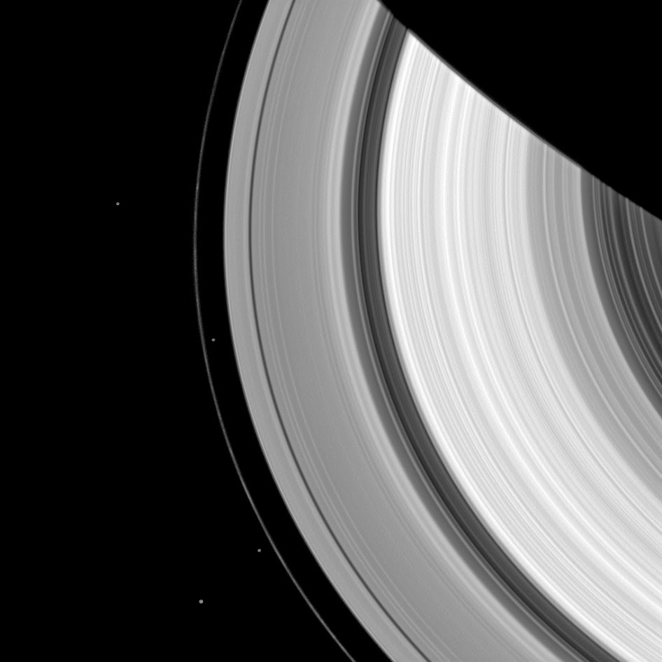
Two pairs of moons make a rare joint appearance. The F ring's shepherd moons, Prometheus and Pandora, appear just inside and outside of the F ring (the thin faint ring furthest from Saturn). Meanwhile, farther from Saturn the co-orbital moons Janus (near the bottom) and Epimetheus (about a third of the way down from the top) also are captured.

Prometheus (53 miles, or 86 kilometers across) and Pandora (50 miles, or 81 kilometers across) sculpt the F ring through their gravitational influences. Janus (111 miles, or  179 kilometers across) and Epimetheus (70 miles, or 113 kilometers across) are famous for their orbital dance, swapping places about every four years. They are also responsible for gravitationally shaping the outer edge of the A ring into seven scallops.

This view looks toward the sunlit side of the rings from about 47 degrees above the ringplane. The image was taken in visible light with the Cassini spacecraft wide-angle camera on Oct. 11, 2013.

The view was acquired at a distance of approximately 810,000 miles (1.3 million kilometers) from Saturn and at a Sun-Saturn-spacecraft, or phase, angle of 47 degrees. Image scale is 47 miles (76 kilometers) per pixel.

Artist's view of Cassini passing Saturn rings

The Cassini-Huygens mission is a cooperative project of NASA, the European Space Agency and the Italian Space Agency. The Jet Propulsion Laboratory, a division of the California Institute of Technology in Pasadena, manages the mission for NASA's Science Mission Directorate, Washington, D.C. The Cassini orbiter and its two onboard cameras were designed, developed and assembled at JPL. The imaging operations center is based at the Space Science Institute in Boulder, Colo.

For more information about the Cassini-Huygens mission visit:  http://www.nasa.gov/cassini and http://saturn.jpl.nasa.gov and http://www.esa.int/Our_Activities/Space_Science/Cassini-Huygens. The Cassini imaging team homepage is at http://ciclops.org.

Images, Text, Credits: NASA / JPL-Caltech / Space Science Institute.

Best regards, Orbiter.ch

Stars and bubbles


ESA - XMM-Newton Mission patch.

March 24, 2014


Massive stars are born in tumultuous clouds of gas and dust. They lead a brief but intense life, blowing powerful winds of particles and radiation that strike their surroundings, before their explosive demise as supernovas.

The interplay between massive stars and their environment is revealed in this image of the star-forming region ON2. It combines X-ray coverage from ESA’s XMM-Newton X-ray observatory with an infrared view from NASA’s Spitzer Space Telescope.

This stellar cradle is associated with the open cluster of stars named Berkeley 87, some 4000 light-years from Earth. The cluster is home to over 2000 stars, most of which are low-mass stars like our Sun or smaller, but some – a few dozen – are stellar monsters weighing 10–80 times more.

Two glowing clouds of gas and dust – the raw material from which stars form – dominate the centre of the image and are shown in red. Scattered across the image are a multitude of protostars – seeds of future stellar generations; these are shown in green. The bright yellow star in the upper part of the image is BC Cygni, a massive star that has puffed up enormously and will eventually explode as a supernova.

ESA's XMM-Newton spacecraft

Shown in blue is XMM-Newton’s X-ray view of ON2: it reveals individual sources – young, massive stars as well as protostars – and more diffuse regions of X-rays. Two ‘bubbles’ of X-rays can be seen in the upper and lower clouds, respectively, pink against the red background. These two bubbles conceal the cumulative emissions from many protostars, but also light radiated by very energetic particles – a signature of shockwaves triggered by massive stars and their winds.

The image combines observations performed in the X-ray energy range of 0.25–12 keV (blue) and at infrared wavelengths of 3.6 microns (green) and 8 microns (red). It spans about 15 arcminutes on each side; north is up and east is to the left.

This image was first published in the paper “Hard X-Ray Emission in the Star-Forming Region ON 2: Discovery with XMM-Newton” by Oskinova et al. in April 2010.

For more information about XMM-Newton Mission, visit: http://xmm.esac.esa.int/ and http://sci.esa.int/xmm-newton/

Images, Text, Credits: L.M. Oskinova, R.A. Gruendl, Spitzer Space Telescope, JPL, NASA & ESA.

Best regards, Orbiter.ch

Satellite Glonass-M was successfully launched into orbit


GLONASS logo.

24.03.2014

The Plesetsk cosmodrome successfully launched satellite

March 24 at 2:00 MSK 54 minutes from the launch complex of the platform 43 State Test Cosmodrome Ministry of Defense of the Russian Federation the cosmodrome Plesetsk made ​​space rocket Soyuz-2.1b with the upper stage (RB) Fregat and spacecraft (SC) Glonass-M. Start calculation made ​​joint Russian Defense Ministry experts and enterprises aerospace industry.

Glonass-M navigation satellite

In accordance with cyclogram flight spacecraft Glonass-M manufactured by JSC Information Satellite Systems them. (Academician Reshetnev Zheleznogorsk) injected into the target orbit and adopted by the management. He will join the existing constellation of domestic global navigation satellite system GLONASS. Prior to the launch of on-orbit spacecraft were 28 GLONASS system. 24 of them have been used for their intended purpose, three were Spares, and another was on the flight tests phase.

Rocket Soyuz-2.1b established in FSUE SRP TsSKB Progress (Samara), the upper stage Fregat "made ​​in FSUE" NPO. Lavochkin.


GLONASS system is defined as a dual-use system that provides the solution of problems in the interests of the Russian Defense Ministry and civilian users. Access to civilian navigation signals of global navigation satellite system GLONASS available to Russian and foreign consumers at no cost and without restrictions.

ROSCOSMOS Press Release: http://www.federalspace.ru/20378/

Images, Video, Text, Credits:  Roscosmos press service / ROSCOSMOS TV / Rianovosti / Translation: Orbiter.ch Aerospace.

Greetings, Orbiter.ch
dimanche 23 mars 2014

Launch of Soyuz-2.1b with spacecraft Glonass-M


ROSCOSMOS - GLONASS logo.

24.03.2014

Soyuz-2.1b launch

March 24 at 2:00 and 54 minutes (MSK) from Launch Complex 43 pad of Plesetsk cosmodrome starting calculations Forces Aerospace Defense with the participation of specialists of rocket-space industry Russia conducted a successful launch of a space rocket Soyuz-2.1b spacecraft Glonass-M.

Glonass-M navigation satellite

A Russian government Soyuz rocket will launch a Glonass-M navigation satellite. The rocket was in the Soyuz 2-1b configuration with a Fregat upper stage.

Targeting of the satellite orbit Glonass-M is planned in 06.26 MSK (Moscow Time).

ROSCOSMOS Press Release: http://www.federalspace.ru/20377/

Images, Text, Credits: Roscosmos press service / ROSCOSMOS / Translation: Orbiter.ch Aerospace.

Cheers, Orbiter.ch