mardi 29 avril 2014

Vega another light-lift success!


ESA / ARIANESPACE - Flight VV03 poster.


April 29, 2014

Vega Flight VV03

The latest Vega launch delivers Kazakhstan’s first Earth observation satellite to orbit

Vega flight VV03 liftoff! (Screenshot by Juli Fowler)

Arianespace is on track for a record launch performance in 2014 following tonight’s Vega mission from the Spaceport in French Guiana, which successfully orbited a pioneering Earth observation satellite for the Republic of Kazakhstan.

Lifting off from the SLV launch site at 10:35:15 p.m. local time – which was the planned precise moment of launch – Vega was put through its paces to loft DZZ-HR, renamed “KasEOSat-1” after reaching Sun-synchronous orbit, during a flight lasting 55 minutes.

Arianespace Flight VV03 - KasEOSat-1

As a 900-kg.-class Earth observation spacecraft, KasEOSat-1 is to provide the Republic of Kazakhstan with a complete range of civil applications – including monitoring of natural and agricultural resources, provision of mapping data, and support for rescue operations in the event of a natural disaster.

Tonight’s mission – designated Flight VV03 – marked the third launch of a Vega, which joins Arianespace’s medium-lift Soyuz and heavyweight Ariane 5 to form the world’s most capable family of launchers, operating side-by-side at the Spaceport.

Conceived for the orbiting of small- to medium-sized satellites, including institutional and scientific spacecraft, Vega was developed in the framework of a European Space Agency (ESA) program financed by Italy, France, Germany, Spain, Belgium, the Netherlands, Switzerland and Sweden.  The launcher design authority and prime contractor is Italy’s ELV – a joint venture company of Avio and the Italian ASI space agency – while Arianespace is responsible for handling the launch operations.

KasEOSat-1 satellite (Credit: Günter Space Page)

The first Vega launch (designated Flight VV01 in Arianespace’s numbering system) was a qualification mission performed in February 2012, carrying the LARES laser relativity satellite, a small ALMASat-1 technology microsatellite demonstrator, and seven CubeSats.   It was followed by Flight VV02 in May 2013, which orbited the Proba-V, VNREDSat-1 and ESTCube-1 satellites.

Tonight’s Vega success was Arianespace’s fourth mission so far in 2014, putting the company on track to perform a total of 12 launches from Europe’s Spaceport during the year – which would mark a new record, surpassing the 10-launch mark set in 2012. It follows the Ariane 5 flight that orbited ABS-2 and Athena-Fidus in February; Ariane 5’s March success with ASTRA 5B and Amazonas 4A; and the Soyuz mission to loft Sentinel-1A earlier this month.

Related links:

Arianespace website: http://www.arianespace.com/index/index.asp

Airbus Defence and Space website: http://airbusdefenceandspace.com/

European Space Agency website: http://www.esa.int/ESA

Italian Space Agency: http://www.asi.it/en

ELV, SpA website: http://www.elv.it/en

Images (mentioned), Video, Text, Credits: Arianespace / Arianespace TV / Launch screen capture by Juli Fowler.

Best regards, Orbiter.ch

NASA Satellite Sees Colder Temperatures in Severe Weather Thunderstorms


NASA - Aqua Mission logo.

April 29, 2014

The weather system that dropped tornadoes in seven central and southern U.S. states on April 27-28, moved east and generated more tornadoes on April 29. NASA's Aqua satellite gathered temperature data on the thunderstorm cloud tops in the system and found them to be higher in the atmosphere and colder. The tornado outbreak over the evening and overnight hours of April 28-29 is thought to have generated more tornadoes in northern Mississippi and Alabama.

NASA's Aqua satellite passed over the eastern U.S. early in the morning on April 29 at 07:41 UTC/3:41 a.m. EDT and gathered infrared data associated with the storms associated with the frontal system that generated tornadoes on April 28 and early this morning, April 29. The Atmospheric Infrared Sounder (AIRS) instrument that flies aboard NASA's Aqua satellite provided that infrared data. A false-colored image of the storm system using the infrared data was created by NASA's Jet Propulsion Laboratory (JPL) in Pasadena, Calif.


Image above: On April 29 at 3:41 a.m. EDT, NASA's Aqua satellite's infrared data showed very high, powerful thunderstorms (purple) in the frontal system that generated more tornadoes. Image Credit: NASA/JPL, Ed Olsen.

The AIRS image showed very cold cloud top temperatures indicating that the thunderstorms had strong uplift that pushed cloud tops near the top of the troposphere. Temperatures drop to just under 220 degrees kelvin at the top of the troposphere (and where the tropopause begins).

In the early morning imagery from today (April 29) AIRS data showed minimum temperature to be near 190 kelvin (-117.7 F/-83.1 C), which is even colder than yesterday. That means the storms early this morning were higher in the atmosphere and had the potential to be stronger than those on April 28. On April 28, AIRS data showed some thunderstorms with cloud tops as cold as 200 kelvin (-99.6 F/-73.1C).


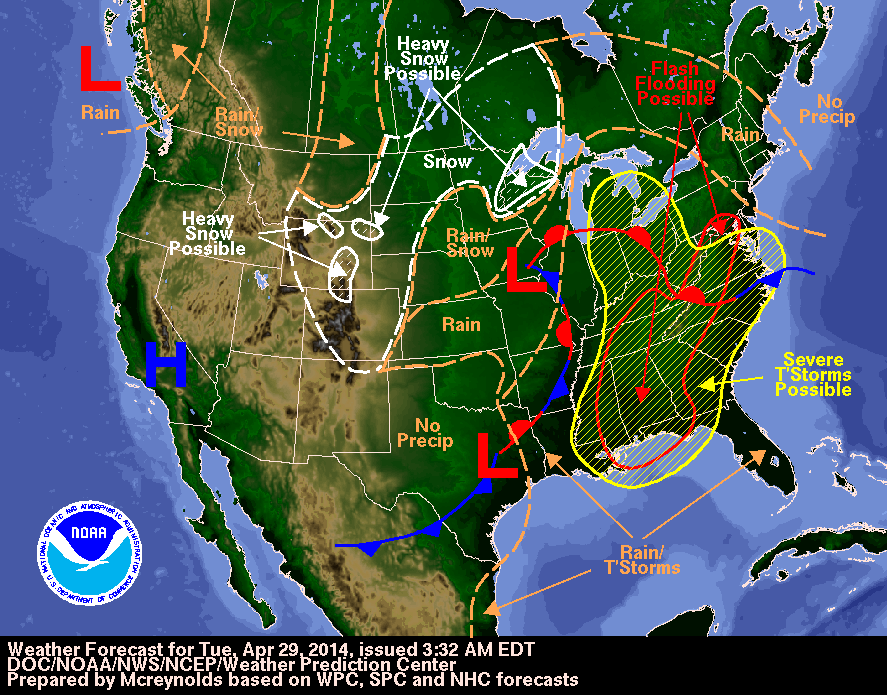
Image above: NOAA's National Forecast chart for April 29, 2014 showed a large area in the Eastern U.S. that has the potential for severe weather (yellow).
Image Credit: NOAA.

A low pressure center associated with the fronts is located over Iowa. A warm front extends east of the low bringing warm, moist air into the southeastern U.S. A stationary front stretches south from that low pressure area to another low.

pressure area over eastern Texas. NOAA's National Weather Service Storm Prediction Center is forecasting "Severe thunderstorms expected over parts of the Gulf Coast States this afternoon and tonight."

For updated information about the storm system, visit NOAA's NWS website: http://www.weather.gov

For more information about GOES satellites, visit: http://www.goes.noaa.gov/ or http://goes.gsfc.nasa.gov/

Images (mentioned), Text, Credits: NASA's Goddard Space Flight Center / Rob Gutro.

Greetings, Orbiter.ch

Me and My Shadow


NASA / ESA - Cassini Mission to Saturn patch.

April 29, 2014


Saturn's rings cast shadows on the planet, but the shadows appear to be inside out! The edge of Saturn's outermost A ring can be seen at the top left corner of the image.  Moving towards the bottom of the page, one can see the faint Cassini Division, the opaque B ring and the innermost C ring, which contains several ringlets that appear dark against Saturn in this geometry.  The bottom half of the image features the shadows of these rings in reverse order superposed against the disk of the planet: the C ring, the B ring, the Cassini Division and the inner half of the A ring.

This view looks toward the unilluminated side of the rings from about 28 degrees below the ringplane. The image was taken with the Cassini spacecraft wide-angle camera on Dec. 2, 2013, using a spectral filter which preferentially admits wavelengths of near-infrared light centered at 752 nanometers.

The view was acquired at a distance of approximately 750,000 miles (1.2 million kilometers) from Saturn and at a Sun-Saturn-spacecraft, or phase, angle of 57 degrees. Image scale is 45 miles (72 kilometers) per pixel.

The Cassini-Huygens mission is a cooperative project of NASA, the European Space Agency and the Italian Space Agency. The Jet Propulsion Laboratory, a division of the California Institute of Technology in Pasadena, manages the mission for NASA's Science Mission Directorate, Washington, D.C. The Cassini orbiter and its two onboard cameras were designed, developed and assembled at JPL. The imaging operations center is based at the Space Science Institute in Boulder, Colo.

For more information about the Cassini-Huygens mission, visit http://www.nasa.gov/cassini and http://saturn.jpl.nasa.gov and http://www.esa.int/Our_Activities/Space_Science/Cassini-Huygens. The Cassini imaging team homepage is at http://ciclops.org.

Image, Text, Credit: NASA / JPL-Caltech / Space Science Institute.

Cheers, Orbiter.ch

Herschel discovers mature galaxies in the young Universe


ESA - Herschel Mission patch.

29 April 2014

New Herschel results have given us a remarkable insight into the internal dynamics of two young galaxies. Surprisingly, they have shown that just a few billion years after the Big Bang, some galaxies were rotating in a mature way, seemingly having completed the accumulation of their gas reservoirs.

When galaxies form, they accumulate mass by gravitationally attracting vast, external gas clouds. As the gas clouds enter the galaxy, they fall into haphazard orbits. These disordered paths cause turbulence in the host galaxies, which can drive star formation.

To investigate the internal conditions of forming galaxies James Rhoads and Sangeeta Malhotra, both from Arizona State University, and colleagues targeted two young galaxies, known as S0901 and the Clone. The light from both galaxies has taken 10 billion years to reach us across space. Thus, we are seeing them when they were comparatively young.


Image above: Lensed image of galaxy S0901. Credit: NASA/STScI; S. Allam and team; and the Master Lens Database (masterlens.org), L. A. Moustakas, K. Stewart, et al. (2014).

"The purpose of this project is to study the physical conditions of gas in those galaxies. We wanted to know: are they similar to the galaxies around us or is there some difference in their physical conditions," says Rhoads.

The two galaxies they choose to study are average galaxies for that time in cosmic history. This means that they are about 10-20 per cent the size of our Milky Way, which is considered an average galaxy in the present-day Universe.

Studying galaxies so far away is usually hampered because they appear too dim to study effectively but in this case, the researchers were helped by a cosmic magnifier known as a gravitational lens. The two galaxies both sit behind intervening groups of galaxies, whose gravity warps space. As described by Albert Einstein's General Theory of Relativity, this warping acts like a lens. Although it distorts the images of the young galaxies, it helps by magnifying their light, thus bringing them within reach of Herschel's HIFI instrument.

The researchers used HIFI to investigate the infrared light of ionized carbon, which is emitted at a wavelength of 158 micrometres (a frequency of 1900 GHz). This spectral line is produced in the clouds that surround star-forming regions. HIFI showed the line was broadened into a double peak, and this allowed the motion of the gas to be fitted with a model.


Graphic above: Herschel spectrum of the galaxy S0901. Credit: ESA/Herschel/HIFI. Acknowledgments: James Rhoads and Sangeeta Malhotra, Arizona State University, USA.

Firstly, the team fitted the overall rotation of the galaxy, and then the turbulence in the gas clouds. To their surprise they found that galaxy S0901 was extremely well behaved. Instead of turbulence, it was found to be in orderly rotation, much more akin to the majestic galaxies of today.

"Usually, when astronomers examine galaxies at this early era, they find that turbulence plays a much greater role than it does in modern galaxies. But S0901 is a clear exception to that pattern, and the Clone could be another," says Rhoads.

The Clone, the second galaxy in their study, could also be fitted by an orderly rotation. However, because it was somewhat dimmer, the quality of the data was not so good. This meant that the data could also be fitted with a highly turbulent model, as conventional wisdom would expect.

"Galaxies 10 billion years ago were making stars more actively than they do now," says Malhotra, "They usually also show more turbulence, likely because they are accumulating gas faster than a modern galaxy does. But here we have cases of early galaxies that combine the 'calm' rotation of a modern one with the active star formation of their early peers. This suggests first that these galaxies have finished accumulating their gas, at least for now. But it also seems that turbulence is not actually required to trigger that early, active star formation."


Image above: Herschel spectrum of the Clone. Credit: ESA/Herschel/HIFI. Acknowledgments: James Rhoads and Sangeeta Malhotra, Arizona State University, USA.

Malhotra acknowledges the preliminary nature of their study. "This is not the last word on this. We need a bigger sample to be sure of our conclusions," she says.

But that bigger sample will not be investigated by Herschel. As predicted, the liquid helium coolant needed to keep HIFI and Herschel's other instruments working ran out in April 2013. Instead the researchers hope to continue the work pioneered by Herschel using the Atacama Large Millimeter/submillimeter Array (ALMA), a ground-based array of 66 radio dishes in Chile.

"It is mind-boggling that with Herschel/HIFI – admittedly with the help of gravitational lensing – it has been possible to study the internal gas kinematics in galaxies when the Universe was only a few billion years old, and what we can learn about them this way. This pioneering work by Herschel is bound to be continued," says Göran Pilbratt, Herschel Project Scientist at ESA.

Background Information

The study reported here is based on observations performed with the Heterodyne Instrument for the Far-Infrared (HIFI) on board ESA's Herschel Space Observatory of SDSS090122.37+181432.3, referred to as S0901, and SDSS J120602.09+514229.5, known as the Clone. The results are published in "Herschel Extreme Lensing Line Observations: Dynamics of two strongly lensed star forming galaxies near redshift z = 2", by J. Rhoads et al., to appear in the 2014 May 20 issue of The Astrophysical Journal, volume 787, issue 1.

Herschel is an ESA space observatory with science instruments provided by European-led Principal Investigator consortia and with important participation from NASA.

The HIFI instrument is a very high-resolution heterodyne spectrometer and operates in seven bands covering the wavelength range between 157 and 625 µm. HIFI has been designed and built by a consortium of institutes and university departments across Europe, Canada, and the United States under the leadership of SRON Netherlands Institute for Space Research, the Netherlands, with major contributions from Germany, France, and the USA. HIFI Consortium members are: CSA, U. Waterloo (Canada); CESR, LAB, LERMA, IRAM (France); KOSMA, MPIfR, MPS (Germany); NUI Maynooth (Ireland); ASI, IFSI-INAF, Osservatorio Astrofisico di Arcetri-INAF (Italy); SRON, TUD (Netherlands); CAMK, CBK (Poland); Observatorio Astronómico Nacional (IGN), Centro de Astrobiología (CSIC-INTA) (Spain); Chalmers University of Technology - MC2, RSS & GARD, Onsala Space Observatory, Swedish National Space Board, Stockholm University - Stockholm Observatory (Sweden); ETH Zurich, FHNW (Switzerland); Caltech, JPL, NHSC (USA).

Herschel was launched on 14 May 2009 and completed science observations on 29 April 2013.

For more information about Herschel Mission, visit: http://www.esa.int/Our_Activities/Space_Science/Herschel

Images (mentioned), Text, Credit: ESA.

Greetings, Orbiter.ch

Orbit Height of the International Space Station increased of 2.15 km


ROSCOSMOS - Russian Vehicles patch.

04/29/2014

April 29, 2014 underwent elective correction orbit of the International Space Station.

According to calculations by the ballistic and navigation support Mission Control Center FSUE TsNIIMash today in 11 hours and 45 minutes Moscow time included engines cargo spacecraft Progress M-21M. Ship's engines worked 566.8 seconds. As a result, ISS received a velocity increment of 1.23 m/s. The average height of the station's orbit has increased by 2.15 km (1mi 974.03yd) and reached 417.2 km (259mi 415.47yd).

ISS reboost by Progress-M

Orbit correction station flight was performed in order to create optimal conditions for docking with the ISS manned spacecraft Soyuz TMA-13M with a new crew, the launch of which is scheduled for May 28 from the Baikonur Cosmodrome.

ROSCOSMOS Press Release: http://www.federalspace.ru/20527/

Image, Text, Credits: Roscosmos press service / NASA / Translation: Orbiter.ch Aerospace.

Cheers, Orbiter.ch

lundi 28 avril 2014

Satellite Movie Shows U.S. Tornado Outbreak from Space


NOAA logo.

April 28, 2014

GOES Animation of the Tornadoes from Apr. 27-28, 2014

Video above: This animation of NOAA's GOES-East satellite data shows the development and movement of the weather system that spawned tornadoes affecting seven central and southern U.S. states on April 27-28, 2014. Image Credit: NASA/NOAA GOES Project.

NASA has just released an animation of visible and infrared satellite data from NOAA's GOES-East satellite that shows the development and movement of the weather system that spawned tornadoes affecting seven central and southern U.S. states on April 27-28, 2014. NASA's Aqua satellite captured infrared data on the system that revealed powerful storms, high into the troposphere.

This storm system generated reports of tornadoes from Nebraska, Kansas, Iowa, Oklahoma, Arkansas, Louisiana, and Mississippi.

NOAA's GOES-East satellite. Image Credit: NOAA

Coupled with local weather observations, soundings, and computer models, data from satellites like NOAA's Geostationary Operational Environmental Satellite or GOES-East (also known as GOES-13) gives forecasters information about developing weather situations. In real-time, the NOAA's GOES-East satellite data in animated form showed forecasters how the area of severe weather was developing and moving.


Image above: This NOAA GOES-East satellite image from Monday, April 28, 2014 at 13:01 UTC/9:01 a.m. EDT shows the same storm system that generated the severe weather outbreak yesterday, has moved to the east. Image Credit: NASA/NOAA GOES Project.

NOAA's GOES-East satellite sits in a fixed orbit in space capturing visible and infrared imagery of weather over the eastern U.S. and Atlantic Ocean. The GOES-East satellite is operated by the National Oceanic and Atmospheric Administration. NASA/NOAA's GOES Project at the NASA Goddard Space Flight Center in Greenbelt, Md. created the animation of GOES-East satellite data that covered the period during the tornado outbreak.

The GOES-East animation of visible and infrared imagery runs 31 seconds. The animation begins on April 27 at 00:15 UTC (April 26 at 8:15 p.m. EDT) and runs through April 28 at 14:15 UTC/10:15 a.m. EDT. By 14:45 UTC/10:45 a.m. EDT on April 27 the animation shows the squall line of thunderstorms developing.

To create the video and imagery, NASA/NOAA's GOES Project takes the cloud data from NOAA's GOES-East satellite and overlays it on a true-color image of land and ocean created by data from the Moderate Resolution Imaging Spectroradiometer (MODIS) instrument that flies aboard NASA's Aqua and Terra satellites. Together, those data created the entire picture of the storm system and show its movement.


Image above: This false-colored infrared image from the AIRS instrument aboard NASA's Aqua satellite shows the cold cloud top temperatures associated with the severe thunderstorms that brought severe weather to seven states on April 27. Image Credit: NASA/JPL, Ed Olsen.

A NASA satellite also captured an image of the storm, collecting infrared data on it as it passed overhead on April 27. At NASA's Jet Propulsion Laboratory (JPL) in Pasadena, Calif. a false-colored image was created of the storm system using data gathered by the Atmospheric Infrared Sounder (AIRS) instrument that flies aboard NASA's Aqua satellite on April 27 at 18:59 UTC (1:59 p.m. CDT). The AIRS image showed very cold cloud top temperatures indicating that the thunderstorms had strong uplift that pushed cloud tops to the top of the troposphere. Some of those thunderstorms had cloud tops as cold as 200 kelvin (-99.6 F/-73.1C). Temperatures drop to just under 220 degrees kelvin at the top of the troposphere (and where the tropopause begins).

"AIRS data shows spatial extent of strong convection [rapidly rising air that condenses and forms clouds] in the slow-moving severe storm system that spawned tornadoes in Arkansas, Oklahoma and Iowa," said Ed Olsen, creator of the AIRS image at NASA JPL. The AIRS image showed the thunderstorms with coldest cloud top temperatures stretched from eastern Nebraska, through western Iowa, western Missouri, northern Arkansas and southeast into northern Mississippi and Alabama.

According to the Examiner.com, the National Weather Service’s Storm Prediction Center counted 31 tornadoes on Sunday, April 27, however, that number is being refined as reports are analyzed.


Image above: This image from NOAA's Storm Prediction Center shows preliminary reports of the severe weather outbreak from April 27, 2014. Image Credit: NOAA/SPC.  

CBS News reported that one tornado touched down 10 miles west of Little Rock, Arkansas around 7 p.m. CDT (at around 22:02 UTC in the GOES animation) and stayed on the ground for about 80 miles passing near several suburbs north of the city. That tornado was reported to be one-half mile wide.

The same system that spawned these tornadoes is expected to bring the possibility for severe weather further east on April 28 from Cincinnati, Ohio to New Orleans, La. For more information about current risks for severe weather, visit NOAA's Storm Prediction Center at: http://www.spc.noaa.gov.

GOES satellites provide the kind of continuous monitoring necessary for intensive data analysis. Geostationary describes an orbit in which a satellite is always in the same position with respect to the rotating Earth. This allows GOES to hover continuously over one position on Earth's surface, appearing stationary. As a result, GOES provide a constant vigil for the atmospheric "triggers" for severe weather conditions such as tornadoes, flash floods, hail storms and hurricanes.

To download the GOES animation:  http://goes.gsfc.nasa.gov/pub/goes/QTmovies/140427-8_tornados.mov

For updated information about the storm system, visit NOAA's NWS website:  http://www.weather.gov

For more information about GOES satellites, visit: http://www.goes.noaa.gov/ or http://goes.gsfc.nasa.gov/

Images (mentioned), Video (mentioned), Text, Credit: NASA's Goddard Space Flight Center / Rob Gutro.

Greetings, Orbiter.ch

Drill Here? NASA's Curiosity Mars Rover Inspects Site


NASA - Mars Science Laboratory (MSL) patch.

April 28, 2014

Sandstone Target 'Windjana' May Be Next Martian Drilling Site

Image above: NASA's Curiosity Mars rover has driven within robotic-arm's reach of the sandstone slab at the center of this April 23 view from the rover's Mast Camera. The rover team plans to have Curiosity examine a target patch on the rock, called "Windjana," to aid a decision about whether to drill there. Image Credit: NASA/JPL-Caltech/MSSS.

The team operating NASA's Curiosity Mars rover is telling the rover to use several tools this weekend to inspect a sandstone slab being evaluated as a possible drilling target.

If this target meets criteria set by engineers and scientists, it could become the mission's third drilled rock, and the first that is not mudstone. The team calls it "Windjana," after a gorge in Western Australia.

The planned inspection, designed to aid a decision on whether to drill at Windjana, includes observations with the camera and X-ray spectrometer at the end of the rover's arm, use of a brush to remove dust from a patch on the rock, and readings of composition at various points on the rock with an instrument that fires laser shots from the rover's mast.

Curiosity Mars Rover Beside Sandstone Target 'Windjana'

Image above: This image from the Navigation Camera on NASA's Curiosity Mars rover shows a sandstone slab on which the rover team has selected a target, "Windjana," for close-up examination. The target is on the approximately 2-foot-wide rock seen in the right half of this April 23, 2014, view. Image Credit: NASA/JPL-Caltech.

Curiosity's hammering drill collects powdered sample material from the interior of a rock, and then the rover prepares and delivers portions of the sample to onboard laboratory instruments. The first two Martian rocks drilled and analyzed this way were mudstone slabs neighboring each other in Yellowknife Bay, about 2.5 miles (4 kilometers) northeast of the rover's current location at a waypoint called "the Kimberley." Those two rocks yielded evidence of an ancient lakebed environment with key chemical elements and a chemical energy source that provided conditions billions of years ago favorable for microbial life.

From planned drilling at Windjana or some nearby location on sandstone at the Kimberley, Curiosity's science team hopes to analyze the cement that holds together the sand-size grains in the rock.

"We want to learn more about the wet process that turned sand deposits into sandstone here," said Curiosity Project Scientist John Grotzinger, of the California Institute of Technology in Pasadena. "What was the composition of the fluids that bound the grains together? That aqueous chemistry is part of the habitability story we're investigating."

Location of Mars Sandstone Target 'Windjana'

Image above: In this Mars Reconnaissance Orbiter view of the Curiosity rover mission's waypoint called "the Kimberley," the red dot indicates the location of a sandstone target, "Windjana," selected for close-up inspection. The image was taken April 11, 2014, before the rover arrived at Windjana. Image Credit: NASA/JPL-Caltech/Univ. of Arizona.

Understanding why some sandstones in the area are harder than others also could help explain major shapes of the landscape where Curiosity is working inside Gale Crater. Erosion-resistant sandstone forms a capping layer of mesas and buttes. It could even hold hints about why Gale Crater has a large layered mountain, Mount Sharp, at its center.

NASA's Mars Science Laboratory Project is using Curiosity to assess ancient habitable environments and major changes in Martian environmental conditions. NASA's Jet Propulsion Laboratory, a division of Caltech, built the rover and manages the project for NASA's Science Mission Directorate in Washington.

The spectrometer on the rover's robotic arm is the Alpha Particle X-Ray Spectrometer (APXS), which was provided by the Canadian Space Agency. The camera on the arm is the Mars Hand Lens Imager (MAHLI), built and operated by Malin Space Science Systems, San Diego. The laser on the mast is part of the Chemistry and Camera instrument (ChemCam), from the U.S. Department of Energy's Los Alamos National Laboratory in New Mexico and the French national space agency, CNES. The rover's wire-bristle brush, the Dust Removal Tool, was built by Honeybee Robotics, New York.  

For more information about Curiosity, visit http://www.nasa.gov/msl and http://mars.jpl.nasa.gov/msl/. You can follow the mission on Facebook at http://www.facebook.com/marscuriosity and on Twitter at  http://www.twitter.com/marscuriosity.

Images (mentioned), Text, Credits: NASA / JPL / Guy Webster.

Cheers, Orbiter.ch