mercredi 28 mai 2014

Dying sea


ESA - Proba-V Mission logo.

28 May 2014

Aral Sea

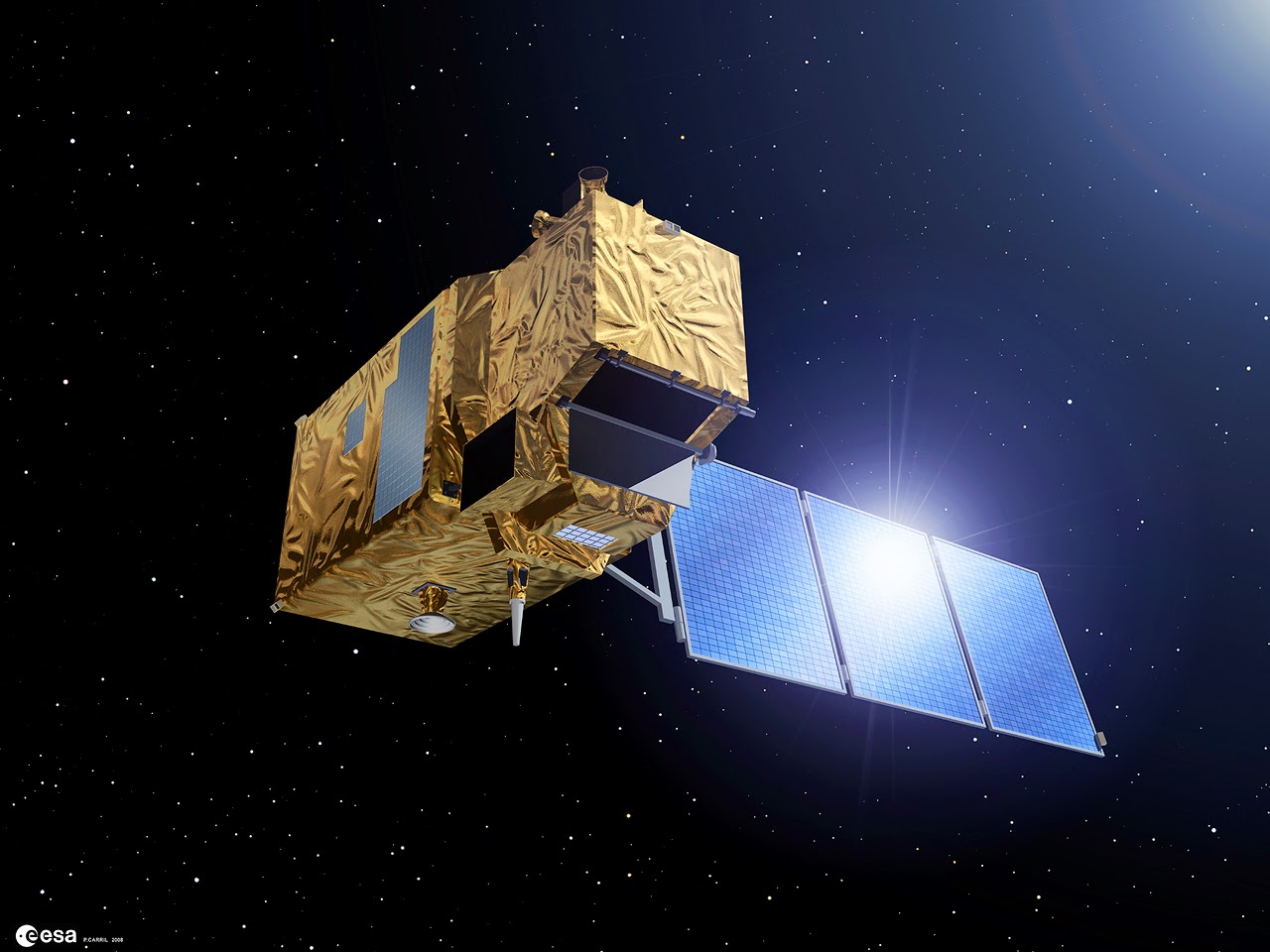
Central Asia’s receding Aral Sea, viewed by ESA’s Proba-V minisatellite, which is about to take up the continuing operational task of tracking global vegetation.

For the last 16 years the Vegetation cameras on France’s full-sized Spot-4 and Spot-5 satellites have been tracking vegetation change on a global basis.

But on 1 June the torch will be passed to Proba-V, ensuring that the Vegetation dataset will remain available to environmental scientists across the world.

Proba-V satellite

The Aral Sea is a striking example of the kind of changes the satellite series has been tracking. Once the world’s fourth-largest inland water body, it has lost around 90% of its water volume since 1960 because of Soviet-era irrigation schemes.

The lake is located on the borders of Kazakhstan and Uzbekistan. The World Bank and Kazakhstan worked together to build the Kok-Aral dike to stabilise the northern section of the Aral Sea.

The Aral Sea’s southern section was beyond saving, however, and is projected to dry out completely by the end of this decade.

Acquired on 13 May 2014, the 300 m-resolution Proba-V image depicts the white salt terrain left behind by the southern Aral Sea receding, now called the Aral Karakum Desert. The greenery to the south is cultivated land irrigated by the Amu Darya river.

For more information about Proba-V mission, visit: http://www.esa.int/Our_Activities/Technology/Proba_Missions/Overview2 and http://www.esa.int/Our_Activities/Observing_the_Earth/Proba-V

Images, Text, Credits: ESA / P. Carril / VITO.

Greetings, Orbiter.ch

Sunsets on Titan Reveal the Complexity of Hazy Exoplanets


NASA / ESA - Cassini-Huygens Mission to Saturn & Titan patch.

May 28, 2014

Scientists working with data from NASA's Cassini mission have developed a new way to understand the atmospheres of exoplanets by using Saturn's smog-enshrouded moon Titan as a stand-in. The new technique shows the dramatic influence that hazy skies could have on our ability to learn about these alien worlds orbiting distant stars.

The work was performed by a team of researchers led by Tyler Robinson, a NASA Postdoctoral Research Fellow at NASA's Ames Research Center in Moffett Field, California. The findings were published May 26 in the Proceedings of the National Academy of Sciences.

"It turns out there's a lot you can learn from looking at a sunset," Robinson said.

Light from sunsets, stars and planets can be separated into its component colors to create spectra, as prisms do with sunlight, in order to obtain hidden information. Despite the staggering distances to other planetary systems, in recent years researchers have begun to develop techniques for collecting spectra of exoplanets. When one of these worlds transits, or passes in front of its host star as seen from Earth, some of the star's light travels through the exoplanet's atmosphere, where it is changed in subtle, but measurable, ways. This process imprints information about the planet that can be collected by telescopes. The resulting spectra are a record of that imprint.

Spectra enable scientists to tease out details about what exoplanets are like, such as aspects of the temperature, composition and structure of their atmospheres.

Robinson and his colleagues exploited a similarity between exoplanet transits and sunsets witnessed by the Cassini spacecraft at Titan. These observations, called solar occultations, effectively allowed the scientists to observe Titan as a transiting exoplanet without having to leave the solar system. In the process, Titan's sunsets revealed just how dramatic the effects of hazes can be.


Image above: Artist's rendering of NASA's Cassini spacecraft observing a sunset through Titan's hazy atmosphere. Image credit: NASA/JPL-Caltech.

Multiple worlds in our own solar system, including Titan, are blanketed by clouds and high-altitude hazes. Scientists expect that many exoplanets would be similarly obscured. Clouds and hazes create a variety of complicated effects that researchers must work to disentangle from the signature of these alien atmospheres, and thus present a major obstacle for understanding transit observations. Due to the complexity and computing power required to address hazes, models used to understand exoplanet spectra usually simplify their effects.

"Previously, it was unclear exactly how hazes were affecting observations of transiting exoplanets," said Robinson. "So we turned to Titan, a hazy world in our own solar system that has been extensively studied by Cassini."

The team used four observations of Titan made between 2006 and 2011 by Cassini's visual and infrared mapping spectrometer instrument. Their analysis provided results that include the complex effects due to hazes, which can now be compared to exoplanet models and observations.

With Titan as their example, Robinson and colleagues found that hazes high above some transiting exoplanets might strictly limit what their spectra can reveal to planet transit observers. The observations might be able to glean information only from a planet's upper atmosphere. On Titan, that corresponds to about 90 to 190 miles (150 to 300 kilometers) above the moon's surface, high above the bulk of its dense and complex atmosphere.

An additional finding from the study is that Titan's hazes more strongly affect shorter wavelengths, or bluer, colors of light. Studies of exoplanet spectra have commonly assumed that hazes would affect all colors of light in similar ways. Studying sunsets through Titan's hazes has revealed that this is not the case.

"People had dreamed up rules for how planets would behave when seen in transit, but Titan didn't get the memo," said Mark Marley, a co-author of the study at NASA Ames. "It looks nothing like some of the previous suggestions, and it's because of the haze."

The team's technique applies equally well to similar observations taken from orbit around any world, not just Titan. This means that researchers could study the atmospheres of planets like Mars and Saturn in the context of exoplanet atmospheres as well.

"It's rewarding to see that Cassini's study of the solar system is helping us to better understand other solar systems as well," said Curt Niebur, Cassini program scientist at NASA Headquarters in Washington.

The Cassini-Huygens mission is a cooperative project of NASA, the European Space Agency and the Italian Space Agency. JPL, a division of the California Institute of Technology, Pasadena, manages the mission for NASA's Science Mission Directorate in Washington. The VIMS team is based at the University of Arizona in Tucson.

More information about Cassini is available at the following sites:

http://www.nasa.gov/cassini

http://saturn.jpl.nasa.gov

http://www.esa.int/Our_Activities/Space_Science/Cassini-Huygens

Image (mentioned), Text, Credits: NASA / JPL / Preston Dyches.

Best regards, Orbiter.ch

Sentinel-1 aids Balkan flood relief


ESA - Sentinel-1 Mission logo.

28 May 2014

Although not yet operational, the new Sentinel-1A satellite has provided radar data for mapping the floods in Bosnia and Herzegovina.

Heavy rainfall leading to widespread flooding and landslides has hit large parts of the Balkans, killing dozens of people and leaving hundreds of thousands displaced.

Jan Kucera of the Europan Commission’s Joint Research Centre is supervising the technical aspect of the Copernicus Emergency Management Service (EMS). While mapping the flooding in northeastern Bosnia and Herzegovina, ESA delivered a radar scan from Sentinel-1A: “I had a first look and discovered that we were missing an important flooded area visible in the middle of the image.”

Flood map

Although the radar on Sentinel-1A is still being calibrated, the new information could be integrated into the Copernicus EMS flood maps of the Sava river in the Balatun area in Bosnia and Herzegovina.

“In emergency situations like these, it is important that we optimise all the available data to produce better maps for disaster relief efforts.”

The radar on Sentinel-1 is able to ‘see’ through clouds, rain and in darkness, making it particularly useful for monitoring floods. Images acquired before and after a flood offer immediate information on the extent of inundation and support assessments of property and environmental damage.

Sentinel-1A was launched on 3 April, and is the first in a fleet of Sentinel satellites developed for Europe’s Copernicus environment monitoring programme.

Although the satellite is still being commissioned, this Balkan coverage is an early example of the kind of operational data the mission will provide for emergency response.

Sentinel-1A scan

Once operational, Sentinel-1 will revolutionise the use of satellites in risk assessment management and emergency response with its provision of large amounts of radar data in a systematic fashion.

The new scans are also being used by the International Charter Space and Major Disasters, which was activated by the Russian risk management authorities involved in flood response in Serbia.

The Charter is an international collaboration between the owners and operators of Earth observation missions to provide rapid access to satellite data to help disaster management authorities. 

Related links:

Copernicus Emergency Management Service: http://emergency.copernicus.eu/mapping/copernicus-emergency-management-service

EMS: Floods in Bosnia & Herzegovina: http://emergency.copernicus.eu/mapping/list-of-components/EMSR087/ALL/EMSR087_07BALATUN

International Charter Space and Major Disasters: http://www.disasterscharter.org/

Sentinel-1: http://www.esa.int/Our_Activities/Observing_the_Earth/Copernicus/Sentinel-1

Images, Text, Credits: ESA / European Commission.

Greetings, Orbiter.ch

mardi 27 mai 2014

CERN inspires entrepreneurs for email encryption


CERN - European Organization for Nuclear Research logo.

May 27, 2014

Three young entrepreneurs inspired by their time at CERN have launched ProtonMail External Links icon, a secure email service with a sophisticated encryption system to deter would-be spies.

Computer scientist Andy Yen has been working at CERN since 2009 through his home institutes CalTech and Harvard University in the US. Along with two of his CERN colleagues he recently co-founded a startup company called ProtonMail.

ProtonMail is a new service that provides encrypted email. "The technology means that our email system does not allow us (or anyone else) to read user emails," says Yen. "Access to user data is technically impossible because of the way we have implemented encryption."

The end-to-end encryption means that when you send an email with ProtonMail, your data is already encrypted by the time it reaches the their servers. So the team has no access to your messages, and as they cannot decrypt them, they cannot read them or share them with third parties.

ProtonMail portal

The idea for the company was born last summer in a CERN cafeteria where CERN physicists and engineers regularly share ideas over lunch or coffee.

"Our team met at CERN and early ProtonMail hackathons were held at the famous CERN Restaurant One," says Yen. "We would not be where we are today without the assistance of the over 300 CERN students and staff who offered to test our service, and the informal advice and feedback given to us by members of the CERN computer security team."

"CERN is a true hub for technological collaboration and it's an environment fostering entrepreneurship," says Giovanni Anelli, head of CERN's Knowledge Transfer group. "Over 10,000 scientists from more than 100 different countries and 600 universities and institutes collaborate today with CERN. Knowledge sharing among this large academic community is essential in the scientific discourse and inspires many additional new ideas. ProtonMail is one such example."

ProtonMail was launched last week to the general public. Their Threat Model
External Links icon describes both the threats ProtonMail is designed to guard against, and also the threats it is not designed to counter.

Editor's Note:

CERN is the inventor and creator of the World Wide Web (www.).

The future

CERN is also working on new technologies for quantum computers, we make several teleportation (like Star Trek) experiment data encapsulation on photons (ultimate distance records: 200 meters), quantum computer systems will not be hackable by the current hackers (perhaps by a physicist as Einstein...).

  Quantum computers

A quantum computer would be able to store more bits of information in its memory than there are particles in the universe.

Note:

CERN, the European Organization for Nuclear Research, is one of the world’s largest and most respected centres for scientific research. Its business is fundamental physics, finding out what the Universe is made of and how it works. At CERN, the world’s largest and most complex scientific instruments are used to study the basic constituents of matter — the fundamental particles. By studying what happens when these particles collide, physicists learn about the laws of Nature.

The instruments used at CERN are particle accelerators and detectors. Accelerators boost beams of particles to high energies before they are made to collide with each other or with stationary targets. Detectors observe and record the results of these collisions.

Founded in 1954, the CERN Laboratory sits astride the Franco–Swiss border near Geneva. It was one of Europe’s first joint ventures and now has 20 Member States.

Related links:

ProtonMail: http://protonmail.ch/

CERN's Knowledge Transfer group: http://knowledgetransfer.web.cern.ch/

ProtonMail Threat Model: http://protonmail.ch/blog/protonmail-threat-model

For more information about the European Organization for Nuclear Research (CERN), visit: http://home.web.cern.ch/

Images, Text, Credits: CERN / Cian O'Luanaigh / Alengo / IstockPhoto / Orbiter.ch Aerospace.

Greetings, Orbiter.ch

lundi 26 mai 2014

Sea Launch Successfully Launches EUTELSAT 3B


Sea Launch logo.

May 27, 2014

Zenit-3SL rocket carrying the EUTELSAT 3B spacecraft lifted off

Sea Launch SA has successfully launched the EUTELSAT 3B satellite today from at its ocean-based Launch Platform Odyssey. This marks the completion of Sea Launch’s first mission in 2014, its third for Eutelsat, one of the world’s leading satellite operators,  and its 36th mission overall.

Launch of Eutelsat 3B on Zenit from Sea Launch Platform. Video: Sea Launch TV

The Zenit-3SL rocket carrying the spacecraft lifted off at 14:09:59 Pacific Daylight Time (PDT) on Monday, May 26th (21:09:59 UTC, 23:09:55 CEST) from the launch platform, positioned at 154 degrees West longitude in the Pacific Ocean. One hour later, the Block DM-SL upper stage inserted the satellite, weighing 5,967 kilograms (13,155 lbs.) into geosynchronous transfer orbit, on its way to a final orbital position at 3 degrees East longitude.  Eutelsat acquired the spacecraft’s first signals from orbit shortly after spacecraft separation. All systems performed nominally throughout the launch mission.

Following acquisition of the spacecraft's signal, Sergey Gugkaev, CEO of Sea Launch, congratulated Eutelsat and the satellite’s prime contractor, Airbus Defence and Space.  "I am very pleased to once again announce the successful launch for our valued Eutelsat customer, our third in a row for them.”  Gugkaev continued, “I wish to express my gratitude to all of our colleagues at the launch site, Home Port and production and maintenance facilities for their hard work and dedication to Sea Launch program.”

Spacecraft separation

Michel de Rosen, Eutelsat Chairman and CEO, added “We are delighted to see EUTELSAT 3B on its way to 3 degrees East and thank Sea Launch and Energia for this flawless launch. EUTELSAT 3B will be a powerful asset to our in-orbit resources, enabling us to increase the operational flexibility and reach we provide customers in a vast service area spanning Brazil, Europe, Africa, the Middle East and Central Asia. ”

EUTELSAT 3B spacecraft. Image Credit: EUTELSAT

Based on the Eurostar E3000 platform of Airbus Defence and Space, the EUTELSAT 3B satellite has been designed to operate three commercial payloads in the C, Ku and Ka bands. This tri-band configuration will deliver exceptional levels of in-orbit flexibility and coverage from Eutelsat’s expanding 3° East neighourhood. The satellite will enable Eutelsat to diversify its commercial response to Internet Service Providers, telcos, government agencies and broadcasters operating in Latin America, Europe, Africa, the Middle East and Central Asia. EUTELSAT 3B has a designed in-orbit lifetime exceeding 15 years.

For more information about Sea Launch, visit: http://www.sea-launch.com/

Images (mentioned), Video (mentioned), Text, Credit: Sea Launch, Headquarter Nyon, Switzerland / Screen captures: Orbiter.ch Aerospace, Headquarter Meyrin, Switzerland.

Greetings, Orbiter.ch

Looking ahead to Sentinel-2


ESA - Sentinel 2 Mission logo.

May 26, 2014

With the first Sentinel satellite already in orbit, scientists and users gathered in Italy last week to discuss the progress of the upcoming Sentinel-2 mission and its many applications.

Over 400 attendees from 44 different countries convened at ESA’s ESRIN centre for Earth observation in Frascati, Italy, for the Sentinel-2 for Science workshop.

Sentinel-2 is the second satellite mission being developed for Europe’s Copernicus environment monitoring programme.

Through Copernicus, decision-makers will have access to reliable, timely and accurate information services to manage the environment, understand and mitigate the effects of climate change and ensure civil security.

The two-satellite mission will deliver frequent and high-resolution optical images that will be used for land cover and change detection mapping, agricultural monitoring, disaster control and many other applications.

Monitoring land and coastal zones

Owing to its high resolution of 10 m per pixel and wide swath of 290 km, global products from Sentinel-2 will be able to be applied locally.

“Timely, high-resolution data are needed for the assessment and monitoring of agricultural productivity. Sentinel-2 data at 10 m resolution will transform our ability to effectively monitor the status and trends of agriculture on a global basis, and will significantly assist those countries most at risk,” said John Latham from the UN Food and Agriculture Organisation (FAO).

“FAO is an active partner and champion user of Earth observation data, and an avid supporter of an integrated Earth observation strategy for resource monitoring built on Copernicus and Sentinel data.”

He also stressed the importance of coordination to continue the provision of consistent products as the user community transitions from using data from the US Landsat missions to Sentinel-2. Landsat provided optical imagery for over 40 years, but this role will be taken over by Sentinel-2, which also provides higher resolution and better coverage.

Sentinel-2

Last year, ESA and NASA entered into a collaborative agreement to provide compatible data products between Sentinel-2 and Landsat, bringing greater benefits to the users of the images.

In addition to data continuity, Sentinel-2 will provide a more frequent revisit time compared to Landsat. This is particularly important for tracking land degradation and logging, especially in tropical regions that often experience cloud cover.

“Logging practices and forest degradation processes move fast in tropical regions, and frequent satellite acquisitions are needed in order to track their progress, in particular to identify logging roads and canopy gaps before they are covered by regrowing vegetation,” said Frédéric Achard from the Forest Recourses and Climate Unit at the Joint Research Centre.

“With Sentinel-2, we will have an unprecedented acquisition frequency which will enable us to better assess forest conditions and the extent of forest degradation in the tropics and worldwide.”

Sentinel-2 for Science workshop

Once both satellites are in orbit, Sentinel-2 will provide global coverage every two days.

One of the major victories for the mission’s scientific community was last year’s approval of the European Delegated Act on Copernicus data and information policy. This Act provides free, full and open access to users of environmental data from the Copernicus programme – including data from the Sentinel satellites.

“In addition to the planned longevity of the Sentinel-2 mission, the free and open access to the data will be highly beneficial to scientific activities and promote the development of long-term monitoring programmes,” said Mike Wulder from the Canadian Forest Service of Natural Resources Canada.

“Having a consistent, calibrated and accessible data stream allows for the development of time-series. These time-series allow us to better characterise forest dynamics and ecosystem processes, as well as to improve the outcomes of predictive models.”

Related links:

Sentinel-2 for Science workshop: http://seom.esa.int/S2forScience2014/

Food and Agriculture Organisation (FAO): http://www.fao.org/

Canadian Forest Service: http://www.nrcan.gc.ca/forests

Joint Research Centre: http://ec.europa.eu/dgs/jrc/index.cfm

Related missions:
Sentinels: http://www.esa.int/Our_Activities/Observing_the_Earth/Sentinels_overview_-_obsolete

Sentinel-2: http://www.esa.int/Our_Activities/Observing_the_Earth/Copernicus/Sentinel-2

Images, Video, Text, Credits: ESA  / P. Carril / RapidEye.

Best regards, Orbiter.ch

A peppering of craters at the Moon’s south pole


ESA - SMART 1 Mission patch.

May 26, 2014


The dark and shadowed regions of the Moon fascinate astronomers and Pink Floyd fans alike. Our Moon’s rotation axis has a tilt of 1.5º, meaning that some parts of its polar regions never see sunlight – the bottoms of certain craters, for example, are always in shadow.

Imaged during summertime in the Moon’s southern hemisphere by the Advanced Moon Imaging Experiment on ESA’s SMART-1 spacecraft, this mosaic shows a crater-riddled region spanning the lunar south pole. It is made up of around 40 individual images taken between December 2005 and March 2006, and covers an area of about 500 x 150 km.

The craters visible here include (from right to left, starting with the largest round shape visible in the frame) the Amundsen, Faustini, Shoemaker, Shackleton and de Gerlache craters. Click here for an annotated map.

Amundsen is the largest of the bunch at 105 km across, followed by Shoemaker (50 km), Faustini (39 km), de Gerlache (32 km) and Shackleton (19 km). This group of craters all look different, see varying levels of sunlight and display a range of interesting properties.

Shackleton crater, the small circle visible to the left of centre, contains the south pole within its rim. By using SMART-1 images to explore the number of small impact craters scattered on the smooth, dark surface surrounding Shackleton, scientists have found this crater to be older than the Apollo 15 landing site (3.3 billion years), but younger than the Apollo 14 site (3.85 billion years).

ESA’s SMART-1 spacecraft

Shoemaker crater, visible to the upper left of centre, is notable because of the 1999 Lunar Prospector mission, which deliberately crashed into the crater in an attempt to create a detectable plume of water vapour by heating any water ice that may have been present. No vapour was spotted. However, all is not lost; some permanently shadowed regions have been in the dark for millions of years, and it is still possible that they may contain water ice deposited by comets and water-rich asteroids. 

Studying the dark depths of these craters could tell us not just about the history of the Moon, but also about Earth, helping us to understand better how, and how much, water and organic material may have been transferred from the Moon to Earth over its history.

Related link:

ESA’s SMART-1 spacecraft mission: http://www.esa.int/Our_Activities/Space_Science/SMART-1

Images, Text, Credits: ESA/SMART-1/AMIE camera team; image mosaic: M. Ellouzi/B. Foing.

Cheers, Orbiter.ch