jeudi 24 mars 2016

Working Toward 'Seamless' Infrared Maps of Titan & Cassini Spies Titan's Tallest Peaks


NASA & ESA - Cassini-Huygens Mission to Saturn & Titan patch.

March 24, 2016

Figure A

Each of these two montages shows four synthetic views of Titan created using data acquired by the visual and infrared mapping spectrometer (VIMS) on board NASA's Cassini spacecraft between 2004 and 2015. These views demonstrate some of the progress researchers have made in creating smooth-looking maps of Titan from the multitude of different VIMS observations made under a wide variety of lighting and viewing conditions.

Cassini has flown past Titan about once per month, on average, since 2004, in order to observe the giant moon and to take advantage of its gravity for shaping the spacecraft's trajectory. With each flyby, VIMS has a brief opportunity to add small pieces to the instrument's overall mapping coverage of Titan.

Producing a seamless global map of Titan is a challenging task, because observing conditions can vary greatly between each flyby. Among these variations are changes in the angle of the sun with respect to the surface and in the spacecraft's viewing direction. Such variations can make it even more difficult to remove the effects of scattering and absorption of light by Titan's thick, hazy atmosphere. These effects can also influence how bright different areas of the surface appear. Seasonal changes may also have played a role in changing the appearance of Titan's surface over the course of Cassini's long mission. These factors create a complex problem that researchers are still working to solve.

In each montage, the images from left to right present different views that demonstrate the broad spectral capability of the VIMS instrument. The upper row of images in each montage shows a particular region of interest; one features the 50-mile-wide (80-kilometer-wide) Sinlap impact crater, while the other focuses on the region surrounding the landing site for ESA's Huygens probe. The lower row of images features maps of the hemispheres in which these regions are located.

 Figure B

The images at far left show the surface at 2 microns, a wavelength where the atmosphere is quite transparent to infrared light.

The views at the next position are spectral ratio images -- in which an image at one wavelength is divided by an image at another wavelength. This technique can be used to emphasize subtle spectral variations on the surface, some of which are related to differences in composition.

The third view is a color composite with light at 5 microns shown in red, 2 microns shown in green and 1.27 microns shown in blue. (All component images were corrected for atmospheric and photometric effects.)

The final (rightmost) views are color composites created using ratios that divide the brightness of the surface in one set (or band) of wavelengths by that of another set in order to produce the red, green and blue channels of a color composite image. Like spectral ratio images, these images may reveal differences in the nature of surface materials.

Cassini Spies Titan's Tallest Peaks


Image above: The trio of ridges on Titan known as Mithrim Montes is home to the hazy Saturnian moon's tallest peak. Image Credits: NASA/JPL-Caltech/ASI.

In a nod to extraterrestrial mountaineers of the future, scientists working on NASA's Cassini mission have identified the highest point on Saturn's largest moon, Titan.

Titan's tallest peak is 10,948 feet (3,337 meters) high and is found within a trio of mountainous ridges called the Mithrim Montes. The researchers found that all of Titan's highest peaks are about 10,000 feet (3,000 meters) in elevation. The study used images and other data from Cassini's radar instrument, which can peer through the obscuring smog of Titan's atmosphere to reveal the surface in detail.

"It's not only the highest point we've found so far on Titan, but we think it's the highest point we're likely to find," said Stephen Wall, deputy lead of the Cassini radar team at NASA's Jet Propulsion Laboratory in Pasadena, California.

The results, which use data collected by Cassini's radar instrument, are being presented today at the 47th annual Lunar and Planetary Science Conference at The Woodlands, Texas.

Most of Titan's tallest mountains appear to be close to the equator. The researchers identified other peaks of similar height within the Mithrim Montes, as well as in the rugged region known as Xanadu, and in collections of more isolated peaks called "ridge belts" located near the landing site of ESA's Huygens probe.
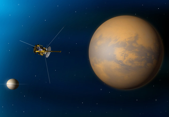
Cassini spacecraft Titan flyby

The investigation was originally motivated by a search for active zones within Titan's crust -- places where dynamic forces have shaped the landscape, perhaps in the relatively recent past.

"As explorers, we're motivated to find the highest or deepest places, partly because it's exciting. But Titan's extremes also tell us important things about forces affecting its evolution," said Jani Radebaugh, a Cassini radar team associate at Brigham Young University in Provo, Utah, who led the research.

Mountains and cliffs on Earth usually are found in locations where forces have shoved the surface upward from underneath. Forces of erosion, including wind, rain and runoff, slowly wear them down over time. The Himalaya and Andes Mountains are examples of places where interior forces are at work today. The Appalachian Mountains represent much more ancient activity that produced similarly gigantic peaks long ago, which have since eroded.

Cassini has found that Titan also has rain and rivers that erode its landscape. According to Radebaugh, the process probably proceeds much more slowly on Titan than on Earth because, at 10 times Earth's distance from the sun, there is less energy to power erosive processes in the moon's atmosphere.


Image above: This map of Saturn's moon Titan identifies the locations of mountains that have been named by the International Astronomical Union. Image Credits: NASA/JPL-Caltech/University of Arizona/USGS.

Titan's icy crust sits atop a deep ocean of liquid water that probably acts much like Earth's upper mantle -- the layer of hot, high-pressure rock below the crust that can slowly flow and deform over time. Once a period of mountain-building ends, these fluid layers (Earth's upper mantle and Titan's liquid ocean) allow the crust to relax, like a person settling into a waterbed. Also, at great depth, the water-ice bedrock of Titan is softer than rock on Earth. Because of these characteristics, scientists didn't expect mountains on Titan would tower quite as high as those on Earth, which can rise to more than 5 miles (nearly 9 kilometers) tall.

The fact that Titan has significant mountains at all suggests that some active tectonic forces could be affecting the surface, for example, related to Titan's rotation, tidal forces from Saturn or cooling of the crust. The next step for the researchers will be trying to figure out what could produce such tall peaks on an icy ocean world.

"There is lot of value in examining the topography of Titan in a broad, global sense, since it tells us about forces acting on the surface from below as well as above," said Radebaugh.

The Cassini mission is a cooperative project of NASA, ESA (the European Space Agency) and the Italian Space Agency. The Jet Propulsion Laboratory, a division of the California Institute of Technology in Pasadena, manages the mission for NASA's Science Mission Directorate, Washington. The Cassini orbiter and its two onboard cameras were designed, developed and assembled at JPL. The visual and infrared mapping spectrometer team is based at the University of Arizona.

For more information about the Cassini-Huygens mission http://saturn.jpl.nasa.gov/home/index.cfm. The visual and infrared mapping spectrometer team homepage is at http://www.vims.lpl.arizona.edu and ESA's website: http://www.esa.int/Our_Activities/Space_Science/Cassini-Huygens

Images, Text, Credits: NASA/Martin Perez/JPL/Preston Dyches.

Greetings, Orbiter.ch

Alluvial Fans in Saheki Crater, Mars


NASA - Mars Reconnaissance Orbiter (MRO) patch.

March 24, 2016


Alluvial fans are gently-sloping wedges of sediments deposited by flowing water. Some of the best-preserved alluvial fans on Mars are in Saheki Crater, an area that has been imaged many times previously.

This observation, captured on Jan. 23, 2016 by the High Resolution Imaging Science Experiment (HiRISE) camera on NASA's Mars Reconnaissance Orbiter, covers two impact craters that expose the stratigraphy of the fans. This image will be used to measure the depth of the fan and describe its depositional history, as well as closer view of some of these layers.

The University of Arizona, Tucson, operates HiRISE, which was built by Ball Aerospace & Technologies Corp., Boulder, Colo. NASA's Jet Propulsion Laboratory, a division of the California Institute of Technology in Pasadena, manages the Mars Reconnaissance Orbiter Project for NASA's Science Mission Directorate, Washington.

Related link:

High Resolution Imaging Science Experiment (HiRISE) camera: http://www.uahirise.org/

For more information about Mars Reconnaissance Orbiter (MRO), visit:
http://www.nasa.gov/mission_pages/MRO/main/index.html

Image, Text, Credits: NASA/JPL-Caltech/Univ. of Arizona/Caption: Alfred McEwen/Sarah Loff.

Greetings, Orbiter.ch

Frosty martian valleys


ESA - Mars Express Mission patch.

24 March 2016

Hellas Basin rim

Nestled within the fractured rim of a vast impact basin on Mars are valley floors dusted in frost.

At 2200 km wide and up to 9 km deep, the Hellas Basin is the largest impact crater on Mars. This scene, captured on 6 December 2015 by ESA’s Mars Express, focuses on a portion of the western rim of the basin.

This region spans a height difference of over 6000 m, stepping down like a staircase from the basin’s fractured, terraced rim to its flat, low-lying floor that is covered in frost or ice.

Hellas Basin rim in context

The surface expression of numerous valley-like features can be seen below the icy covering, indicating a flow of material towards the catchment areas on the floor of Hellas.

For example, towards the centre of the image, a glacier-like flow has carved a valley through the terraced topography, transporting and dumping material into the basin in a fan structure.

Hellas Basin rim topography

Zooming into the channel reveals parallel structures on the surface – ‘lineated valley fill’– that point to the flow of material.

Mass-movement of material can be seen all over the scene. Another example can be found in the small impact crater to the far left of the main image: its rim has been breached, and material has cascaded downhill.

Hellas Basin rim: perspective view

Elsewhere, numerous gullies can be seen etched all along the terraced slopes.

Towards the centre-right of the main images are neighbouring impact craters that have been cross-cut by a fault, creating a small step in the terrain that can be best seen in the 3D anaglyph image.

Hellas Basin rim in 3D

The fault must be younger than the crater that it cuts through, implying that this region could have been subject to later periods of faulting due to subsidence of the terraces.

Related links:

Looking at Mars: http://www.esa.int/Our_Activities/Space_Science/Mars_Express

More about...

Mars Express overview: http://www.esa.int/Our_Activities/Space_Science/Mars_Express_overview

Mars Express 10 year brochure: http://esamultimedia.esa.int/multimedia/publications/BR-312/

Images, Text, Credits: ESA/DLR/FU Berlin/CC BY-SA 3.0 IGO/NASA MGS MOLA Science Team.

Greetings, Orbiter.ch

mercredi 23 mars 2016

Ancient Polar Ice Reveals Tilting of Earth’s Moon


NASA logo.

March 23, 2016

Did the “man in the moon” look different from ancient Earth?

New NASA-funded research provides evidence that the spin axis of Earth’s moon shifted by about five degrees roughly three billion years ago. The evidence of this motion is recorded in the distribution of ancient lunar ice, evidence of delivery of water to the early solar system.

“The same face of the moon has not always pointed towards Earth,” said Matthew Siegler of the Planetary Science Institute in Tucson, Arizona, lead author of a paper in today’s journal Nature. “As the axis moved, so did the face of the ‘man in the moon.’ He sort of turned his nose up at the Earth.”

This interdisciplinary research was conducted across multiple institutions as part of NASA’s Solar System Exploration Research Virtual Institute (SSERVI) based at NASA’s Ames Research Center in Silicon Valley, California.


Image above: This polar hydrogen map of the moon’s northern and southern hemispheres identifies the location of the moon’s ancient and present day poles. In the image, the lighter areas show higher concentrations of hydrogen and the darker areas show lower concentrations. Images Credits: James Keane, University of Arizona; Richard Miller, University of Alabama at Huntsville.

Water ice can exist on Earth’s moon in areas of permanent shadow. If ice on the moon is exposed to direct sunlight it evaporates into space. Authors of the Nature article show evidence that a shift of the lunar spin axis billions of years ago enabled sunlight to creep into areas that were once shadowed and likely previously contained ice. 

The researchers found that the ice that survived this shift effectively “paints” a path along which the axis moved. They matched the path with models predicting where the ice could remain stable and inferred the moon’s axis had moved by approximately five degrees. This is the first physical evidence that the moon underwent such a dramatic change in orientation and implies that much of the polar ice on the moon is billions of years old.

“The new findings are a compelling view of the moon’s dynamic past,” said Dr. Yvonne Pendleton, director of SSERVI, which supports lunar and planetary science research to advance human exploration of the solar system through scientific discovery. “It is wonderful to see the results of several missions pointing to these insights.”

The authors analyzed data from several NASA missions, including Lunar Prospector, Lunar Reconnaissance Orbiter (LRO), Lunar Crater and Observation Sensing Satellite (LCROSS), and the Gravity Recovery and Interior Laboratory (GRAIL), to build the case for a change in the moon’s orientation. Topography from the Lunar Orbiter Laser Altimeter (LOLA) and thermal measurements from the Diviner lunar radiometer – both on LRO – are used to aid the interpretation of Lunar Prospector neutron data that support the polar wander hypothesis.

Siegler noticed that the distribution of ice observed at each of the lunar poles appeared to be more related to each other than previously thought. Upon further investigation, Siegler – and co-author Richard Miller of the University of Alabama at Huntsville – discovered that ice concentrations were displaced from each pole by the same distance, but in exactly opposite directions, suggesting the spin axis in the past was tilted from what we see today. A change in the tilt means that some of the ice deposited long ago has since evaporated as it was exposed to sunlight, but those areas that remain in permanent shadow between the old orientation and the new one retain their ice, and thus indicate what happened.


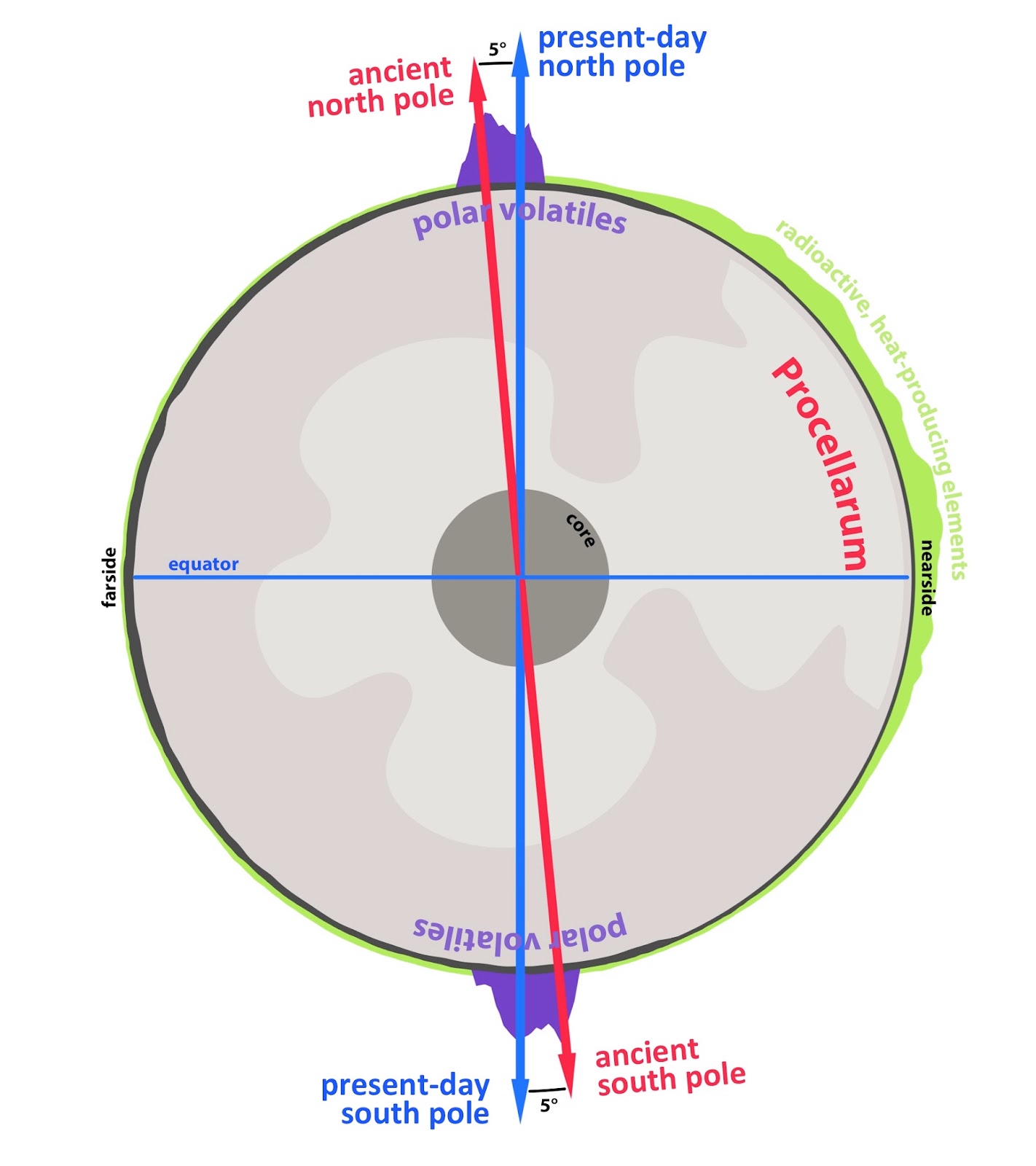
Graphic above: A cross-section through the Moon, highlighting the antipodal nature of lunar polar volatiles (in purple), and how they trace an ancient spin pole. The reorientation from that ancient spin pole (red arrow) to the present-day spin pole (blue arrow) was driven by the formation and evolution of the Procellarum—a region on the nearside of the Moon associated with a high abundance of radiogenic heat producing elements (green), high heat flow, and ancient volcanic activity. Graphic Credits: James Tuttle Keane, University of Arizona.

A planetary body can shift on its axis when there is a very large change in mass distribution. Co-author James Keane, of the University of Arizona in Tucson, modeled the way changes in the lunar interior would have affected the moon’s spin and tilt. In doing so, he found the Procellarum region on the lunar near-side was the only feature that could match the direction and amount of change in the axis indicated by the ice distributions near the poles. Furthermore, concentrations of radioactive material in the Procellarum region are sufficient to have heated a portion of the lunar mantle, causing a density change significant enough to reorient the moon.

Some of this heated mantle material melted and came to the surface to form the visible dark patches that fill large lunar basins known as mare. It’s these mare patches that give the man in the moon his “face.”

Siegler, Miller, and co-author David Lawrence of Johns Hopkins Applied Physics Laboratory in Laurel, Maryland are part of the Volatiles, Regolith and Thermal Investigations Consortium for Exploration and Science team, one of nine teams funded by SSERVI.

Said Siegler, “These findings may open the door to further discoveries on the interior evolution of the moon, as well as the origin of water on the moon and early Earth.”

Related link:

NASA’s Solar System Exploration Research Virtual Institute (SSERVI): http://www.sservi.nasa.gov

For more information about SSERVI and the finding, visit: http://www.sservi.nasa.gov

For more information about NASA’s Ames Research Center, visit: http://www.nasa.gov/ames

Image (mentioned), Graphic (mentioned), Text, Credits: NASA/Ames Research Center/Kimberly Williams.

Greetings, Orbiter.ch

Stressed in space


ESA - European Space Agency patch.

23 March 2016

 Robert Curbeam during the first spacewalk of the STS-116 mission

Living in space is a wonderful experience but it can take its toll on an astronaut’s body – half of astronauts return with weaker immune systems from the International Space Station. ESA astronaut and medical doctor André Kuipers remembers his six-month mission: “Back on Earth, I felt a hundred years old for a few months.”

André Kuipers landing

Many ESA experiments are looking into why this happens and the most recent – Immuno – reveals some striking changes in astronaut immune systems.

Fight or flight

Stress is a response of the body as it adapts to hostile environments. This broad definition includes stress from speaking in front of an audience, stress from a wound or stress from living in weightlessness in a fragile spacecraft far from home.

Strapped to a robotic arm holding 385 kg in space at night

The “feelings” are produced by the central nervous system working closely with our immune system. Stress in the central nervous system invariably influences the immune system and vice versa – people with stressful jobs seem more likely to get sick.

The Immuno experiment had a triple-pronged approach: a questionnaire asked astronauts to assess their own levels of stress while stress-related hormones were measured through saliva and urine samples, and blood samples were taken to analyse immune cell reaction to such environmental stress.

From astronauts to newborns

The research has taken five years to complete and involved meticulous planning to use the limited amount of blood that could be taken from the astronauts, stored in the Space Station’s –80°C freezers and returned to Earth.

Blood draw in space

Through necessity, the researchers developed new ways of analysing small quantities of blood, now being shared with the medical community. “Our methods would interest doctors that care for newborns, who have little blood to give for analysis,” notes Prof. Alexander Choukèr, the lead investigator. His team recently completed a clinical study in adults suffering from inflammation using these tests. 

Rambo-style vs paralysed immune response

Immuno’s 12 cosmonauts  were pretty good at assessing their own stress levels – their questionnaires corresponded with the levels of stress hormones found in samples.

“What was striking and unexpected,” says Prof. Choukèr, “was the ambiguous  immune response we saw in the astronauts’ blood – we saw an over-reaction coupled with severe immune suppression in some areas.”

Melfi freezer: –90°C in space

Small quantities were frozen in space and analysed back on Earth, while more samples of fresh blood taken from the cosmonauts back on Earth were contaminated with common illness-causing pathogens such as fungi, bacteria and herpes.

The researchers found that the immune system reacted heavily to some new threats.

Space Station at night

“What would form a mild immune response in blood of a healthy person on Earth seems to cause immune cells in astronauts to go haywire, overreacting to some of the foreign threats.”

The reason is unknown but the implication is that the immune system adapts to the germ-free environment on the Space Station while staying extra alert, possibly due to the unique environmental stress.

Concordia research base in Antarctica

Further research is concluding with subjects in similar situations on Earth to rule out the effect of weightlessness. Data are being collected from volunteers in remote research bases in Antarctica and a follow-up study is being prepared that will analyse astronaut blood onsite after being taken in space.

Related links:

Experiment archive: http://eea.spaceflight.esa.int/

International Space Station Benefits for Humanity: http://www.esa.int/Our_Activities/Human_Spaceflight/International_Space_Station_Benefits_for_Humanity

European space laboratory Columbus: http://www.esa.int/Our_Activities/Human_Spaceflight/Columbus

Immuno-1 experiment details: http://eea.spaceflight.esa.int/portal/exp/?id=8314

Immuno-2 experiment details: http://eea.spaceflight.esa.int/portal/exp/?id=9516

Images, Text, Credits: ESA/S. Corvaja/NASA/IPEV/PNRA–E. Macdonald-Nethercott.

Best regards, Orbiter.ch

NASA Sends Fire, Meteor Experiments to International Space Station on Commercial Cargo Spacecraft


Orbital ATK / NASA - CRS Cygnus  OA-6 Mission patch.

March 23, 2016


Image above: An Atlas V launch vehicle lifts off from Cape Canaveral Air Force Station carrying a Cygnus resupply spacecraft on the Orbital ATK CRS-6 mission to the International Space Station. Liftoff was at 11:05 p.m. EDT. The spacecraft will deliver 7,500 pounds of supplies, science payloads and experiments. Image Credit: NASA.

Scientific investigations of fire in microgravity and grippers inspired by geckos are among the nearly 7,500 pounds of cargo headed to the International Space Station aboard an Orbital ATK Cygnus spacecraft, along with equipment to support some 250 other experiments and studies aboard the world’s only orbital laboratory.

Supply Spacecraft Heads to the Space Station

Orbital ATK’s fifth cargo delivery flight under its Commercial Resupply Services contract with NASA launched at 11:05 p.m. EDT Tuesday on a United Launch Alliance Atlas V rocket from Space Launch Complex 41 on Cape Canaveral Air Force Station in Florida. The Cygnus is scheduled to arrive at the orbiting laboratory Saturday, March 26.

The station’s Expeditions 47 and 48 crews will employ these science payloads to support experiments in biology, biotechnology, physical science and Earth science – research that improves life on Earth -- including:

- Saffire-I provides a new way to study a large fire on an exploration craft, which has not been possible in the past because the risks for performing such studies on spacecraft with astronauts aboard are too high.

- Meteor will enable the first space-based observations of meteors entering Earth’s atmosphere from space.

- Strata-I could give us answers about how regolith behaves and moves in microgravity, how easy or difficult it is to anchor a spacecraft in regolith, how it interacts with spacecraft and spacesuit materials, and other important properties.

- The Gecko Gripper study tests a gecko-inspired adhesive gripping device that can stick on command in the harsh environment of space.

- The Additive Manufacturing Facility will add an upgraded 3-D printing capability to the station.

NASA astronaut and Expedition 46 Commander Tim Kopra will capture Cygnus at about 6:40 a.m. Saturday, March 26, using the space station's Canadarm2 robotic arm to take hold of the spacecraft. Astronaut Tim Peake of ESA (European Space Agency) will support Kopra in a backup position. NASA TV coverage of capture will begin at 5:30 a.m.

Cygnus resupply cargo. Image Credit: ATK

Saffire-1 will remain on the spacecraft once all the other supplies are unloaded, and the vehicle will be attached to the space station for about two months. Once it departs and the spacecraft is a safe distance from the space station, engineers will remotely conduct the first Saffire experiment before the Cygnus’ destructive reentry into Earth’s atmosphere. Before detaching from the station, Cygnus will also be filled with about 3,000 pounds of trash, which will be burned up over the Pacific Ocean.

This is the second flight of an enhanced Cygnus spacecraft, and the second using the Atlas V launch system. The cargo freighter features a greater payload capacity, supported by new fuel tanks and solar arrays, and an extended pressurized cargo module that increases the spacecraft’s interior volume by 25 percent, enabling more cargo to be delivered with each launch.

The space station is a convergence of science, technology and human innovation that demonstrates new technologies and makes research breakthroughs not possible on Earth. The space station has been continuously occupied since November 2000. In that time, it has been visited by more than 200 people and a variety of international and commercial spacecraft. The space station remains the springboard to NASA's next great leap in exploration, including future missions to an asteroid and Mars.

Related links:

Saffire-I: http://www.nasa.gov/feature/fire-in-the-hole-studying-how-flames-grow-in-space

Meteor: http://www.nasa.gov/mission_pages/station/research/experiments/1323.html

Strata-I: http://www.nasa.gov/mission_pages/station/research/experiments/2146.html

Gecko Gripper: http://www.nasa.gov/jpl/gecko-grippers-moving-on-up

Additive Manufacturing Facility: http://www.nasa.gov/mission_pages/station/research/experiments/2198.html

For more information about Orbital ATK's mission, visit: http://www.nasa.gov/orbitalatk

For more information about the International Space Station, visit: http://www.nasa.gov/station

Images (mentioned), Video, Text, Credits: NASA/NASA TV/Cheryl Warner/Johnson Space Center/Dan Huot/Allard Beutel.

Best regards, Orbiter.ch

mardi 22 mars 2016

Bright Spots and Color Differences Revealed on Ceres


NASA - New Horizons Mission logo.

March 22, 2016

Unveiling Ceres

Video above: NASA's Dawn spacecraft has revealed marvelous sights on dwarf planet Ceres during its first year in orbit.

Scientists from NASA's Dawn mission unveiled new images from the spacecraft's lowest orbit at Ceres, including highly-anticipated views of Occator Crater, at the 47th annual Lunar and Planetary Science Conference in The Woodlands, Texas, on Tuesday.

Occator Crater, measuring 57 miles (92 kilometers) across and 2.5 miles (4 kilometers) deep, contains the brightest area on Ceres, the dwarf planet that Dawn has explored since early 2015. The latest images, taken from 240 miles (385 kilometers) above the surface of Ceres, reveal a dome in a smooth-walled pit in the bright center of the crater. Numerous linear features and fractures crisscross the top and flanks of this dome.  Prominent fractures also surround the dome and run through smaller, bright regions found within the crater.


Image above: Occator Crater, measuring 57 miles (92 kilometers) across and 2.5 miles (4 kilometers) deep, contains the brightest area on Ceres. Image Credits: NASA/JPL-Caltech/UCLA/MPS/DLR/IDA/PSI.

"Before Dawn began its intensive observations of Ceres last year, Occator Crater looked to be one large bright area. Now, with the latest close views, we can see complex features that provide new mysteries to investigate," said Ralf Jaumann, planetary scientist and Dawn co-investigator at the German Aerospace Center (DLR) in Berlin. "The intricate geometry of the crater interior suggests geologic activity in the recent past, but we will need to complete detailed geologic mapping of the crater in order to test hypotheses for its formation."

Color Differences

The team also released an enhanced color map of the surface of Ceres, highlighting the diversity of surface materials and their relationships to surface morphology. Scientists have been studying the shapes of craters and their distribution with great interest. Ceres does not have as many large impact basins as scientists expected, but the number of smaller craters generally matches their predictions. The blue material highlighted in the color map is related to flows, smooth plains and mountains, which appear to be very young surface features.


Image above: Ceres' Haulani Crater (21 miles, 34 kilometers wide) is shown in these views from the visible and infrared mapping spectrometer (VIR) aboard NASA's Dawn spacecraft. Images Credits: NASA/JPL-Caltech/UCLA/ASI/INAF.

"Although impact processes dominate the surface geology on Ceres, we have identified specific color variations on the surface indicating material alterations that are due to a complex interaction of the impact process and the subsurface composition," Jaumann said. "Additionally, this gives evidence for a subsurface layer enriched in ice and volatiles."

Counting Neutrons

Data relevant to the possibility of subsurface ice is also emerging from Dawn's Gamma Ray and Neutron Detector (GRaND), which began acquiring its primary data set in December. Neutrons and gamma rays produced by cosmic ray interactions with surface materials provide a fingerprint of Ceres’ chemical makeup.  The measurements are sensitive to elemental composition of the topmost yard (meter) of the regolith.

In Dawn's lowest-altitude orbit, the instrument has detected fewer neutrons near the poles of Ceres than at the equator, which indicates increased hydrogen concentration at high latitudes. As hydrogen is a principal constituent of water, water ice could be present close to the surface in polar regions.


Image above: This map shows a portion of the northern hemisphere of Ceres with neutron counting data acquired by the gamma ray and neutron detector (GRaND) instrument aboard NASA's Dawn spacecraft. Image Credits: NASA/JPL-Caltech/UCLA/ASI/INAF.

"Our analyses will test a longstanding prediction that water ice can survive just beneath Ceres' cold, high-latitude surface for billions of years," said Tom Prettyman, the lead for GRaND and Dawn co-investigator at the Planetary Science Institute, Tucson, Arizona.

The Mystery of Haulani Crater

But the subsurface does not have the same composition all over Ceres, according to data from the visible and infrared mapping spectrometer (VIR), a device that looks at how various wavelengths of sunlight are reflected by the surface, allowing scientists to identify minerals.

Haulani Crater in particular is an intriguing example of how diverse Ceres is in terms of its surface material composition. This irregularly-shaped crater, with its striking bright streaks of material, shows a different proportion of surface materials than its surroundings when viewed with the VIR instrument. While the surface of Ceres is mostly made of a mixture of materials containing carbonates and phyllosilicates, their relative proportion varies across the surface.


Image above: This colorized global map of Ceres was created from a clear-filter mosaic. Image Credits: NASA/JPL-Caltech/UCLA/MPS/DLR/IDA.

"False-color images of Haulani show that material excavated by an impact is different than the general surface composition of Ceres. The diversity of materials implies either that there is a mixed layer underneath, or that the impact itself changed the properties of the materials," said Maria Cristina de Sanctis, the VIR instrument lead scientist, based at the National Institute of Astrophysics, Rome.

The Big Picture

Dawn made history last year as the first mission to reach a dwarf planet, and the first to orbit two distinct extraterrestrial targets -- both of them in the main asteroid belt between Mars and Jupiter. The mission conducted extensive observations of Vesta during its 14-month orbit there in 2011-2012.


Image above: This global map shows the surface of Ceres in enhanced color, encompassing infrared wavelengths beyond human visual range. Image Credits: NASA/JPL-Caltech/UCLA/MPS/DLR/IDA.

"We're excited to unveil these beautiful new images, especially Occator, which illustrate the complexity of the processes shaping Ceres' surface. Now that we can see Ceres’ enigmatic bright spots, surface minerals and morphology in high resolution, we're busy working to figure out what processes shaped this unique dwarf planet. By comparing Ceres with Vesta, we'll glean new insights about the early solar system," said Carol Raymond, deputy principal investigator for the Dawn mission, based at NASA's Jet Propulsion Laboratory, Pasadena, California.


Image above: The bright spots of Occator Crater are shown in enhanced color in this view from NASA's Dawn spacecraft. Such views can be used to highlight subtle color differences on Ceres' surface. Image Credits: NASA/JPL-Caltech/UCLA/MPS/DLR/IDA/PSI/LPI.

Dawn's mission is managed by JPL for NASA's Science Mission Directorate in Washington. Dawn is a project of the directorate's Discovery Program, managed by NASA's Marshall Space Flight Center in Huntsville, Alabama. UCLA is responsible for overall Dawn mission science. Orbital ATK Inc., in Dulles, Virginia, designed and built the spacecraft. The German Aerospace Center, Max Planck Institute for Solar System Research, Italian Space Agency and Italian National Astrophysical Institute are international partners on the mission team. For a complete list of mission participants, visit:

http://dawn.jpl.nasa.gov/mission

More information about Dawn is available at the following sites:

http://dawn.jpl.nasa.gov

http://www.nasa.gov/dawn

Images (mentioned), Video (mentioned), Text, Credits: NASA/Martin Perez.

Best regards, Orbiter.ch