jeudi 9 février 2017
Probe May Improve Weather Forecasts
NASA Armstrong Flight Research Center Ikhana MQ-9 patch.
Feb. 9, 2017
A weather probe that eventually will relay atmospheric conditions as they are unfolding and provide data to improve weather forecasts and models, has begun to fly on NASA’s Ikhana remotely piloted aircraft.
The flights mark the first time that the Panasonic Tropospheric Airborne Meteorological Data Reporting, or TAMDAR, Edge probe system has flown on an unmanned aircraft system as large as the Ikhana, said Ed Diks, Ikhana deputy project manager. The Ikhana flights are based at NASA Armstrong Flight Research Center in California.
“The weather information can benefit any kind of commercial or military aircraft and it could have uses for unmanned aircraft systems in the future,” Diks said.
Image above: The Ikhana aircraft is flying a TAMDAR Edge probe that could significantly improve weather models and forecasts. Image Credits: NASA Photo/Lori Losey.
The TAMDAR Edge system is a miniaturized, lightweight version of the TAMDAR Edge probe that has been flying on commercial airliners for more than 12 years. Panasonic Weather Solutions and Armstrong have partnered under the Space Act Agreement to develop the technology to greatly enhance flight safety involving weather, Diks said.
Ikhana pilot Hernan Posada sees the value in good weather forecasts.
“Weather is vital to our safe operation of this aircraft,” Posada said. “We adhere to strict airspace rules and manufacturer limits and seeing weather and being able to avoid it is a plus.”
The full capability of the probe will begin later this year when TAMDAR and the Iridium communications satellite network will provide real-time weather to pilots and used to validate and improve weather forecasting models, Diks said. The TAMDAR Edge probe measures and detects real-time weather data including winds aloft, temperature, humidity, GPS position and altitude, pressure, altitude, airspeed, icing presence and turbulence, he added.
“We will verify that we can transmit data and that the recipients of the data can read it,” he explained. “At the moment we have to land, download the data and then complete the analysis. The best operational use for the developers of the system would be to access that information whenever they want it and help develop weather models to make better predictions,” Diks explained.
The benefit to aviation increases in remote areas without major airports that NASA Armstrong missions take place, where there is little or no local weather data, said Scott Wiley, a NASA Armstrong meteorologist.
“We have a lot of data at LAX (Los Angeles International Airport),” he explained. “We have a lot of data in Seattle. We have a lot of data in Chicago. However, we don’t have a lot of data in remote areas. We don’t have any data in the polar regions in places where the DC-8 flies or over hurricanes where the Global Hawk makes observations. We are filling the data gaps with TAMDAR to improve the weather models and forecasts. It’s a tremendous benefit to have this data.”
The TAMDAR Edge probe provides a way to provide weather data that is not available through traditional weather collection tools.
“Meteorologists use the weather data from a number of sources to gather temperature, pressure, wind speed and direction,” Wiley explained. “That data, surface data and radiosonde (sensor packages that usually travel through the atmosphere on weather balloons to gather weather details) data are incorporated into the weather model to come up with a forecast. We are not just forecasting for the surface, but also aloft. Other than the radiosondes that go up twice a day, we really don’t get a lot of airborne data.”
TAMDAR data includes vital moisture readings, Wiley said.
Image above: The TAMDAR Edge probe seen in the middle of the NASA Armstrong Ikhana is flying on a large remotely piloted aircraft for the first time. Image Credits: NASA Photo/Ken Ulbrich.
“Moisture is to the atmosphere as gasoline is to a fire,” Wiley explained. “We need the moisture data. An unstable atmosphere will result in a thunderstorm if we have met the threshold level of moisture, but if we don’t we don’t have a storm. You don’t have to guess with TAMDAR data Conventional weather data from modern aircraft do not often report moisture.”
It also could have a role in NASA’s Unmanned Aircraft Systems in the National Airspace System, or UAS in the NAS. Weather observation is the primary use now and although the probe will be collecting data during upcoming UAS in the NAS missions, it will not directly contribute to that effort or have connectivity with the Iridium satellite network, Diks said.
Another improvement to the TAMDAR Edge probe for NASA research is a heated probe, Wiley said. If a pilot encounters icing, the TAMDAR probe could be a backup detector. In fact, NASA Armstrong and NASA Glenn Research Center in Cleveland are considering working together to test the probe in Glenn’s icing wind tunnel to determine quantitative icing characteristics of trace icing, moderate icing or severe icing using the probe.
The TAMDAR Edge probe also can tie into another NASA Armstrong research project, the Weather Hazard Alert and Awareness Technology Radiation Radiosonde, or WHAATRR Glider, Wiley said. WHAATRR gliders are envisioned as reusable radiosondes that could provide real-time weather data to mission managers and pilots.
“We want to develop a dropsonde capable WHAATRR glider that would be dropped into weather hazards from the TAMDAR Edge equipped DC-8 and Global Hawk,” Wiley said. “The WHAATRR Gliders would fly in areas too dangerous for aircraft, while the Global Hawk and DC-8 motherships would fly all-around and especially upstream of the hazards and providing valuable data used to forecast changes in intensity, motion and size. Current costs of evacuating a coastline for hurricane warning costs $1 million a mile. Forecasting the exact hurricane landfall would save a lot of money for cities, states and emergency services.”
Armstrong Flight Research Center: https://www.nasa.gov/centers/armstrong/home/index.html
Aeronautics: https://www.nasa.gov/topics/aeronautics/index.html
Images (mentioned), Text, Credits: NASA Armstrong Flight Research Center/Jay Levine, X-Press editor/Monroe Conner.
Greetings, Orbiter.ch
NASA Spacecraft Prepares to Fly to New Heights
NASA - MMS Mission patch.
Feb. 9, 2017
On Feb. 9, 2017, NASA’s Magnetospheric Multiscale mission, known as MMS, began a three-month long journey into a new orbit. MMS flies in a highly elliptical orbit around Earth and the new orbit will take MMS twice as far out as it has previously flown. In the new orbit, which begins the second phase of its mission, MMS will continue to map out the fundamental characteristics of space around Earth, helping us understand this key region through which our satellites and astronauts travel. MMS will fly directly through regions – where giant explosions called magnetic reconnection occur – never before observed in high resolution.
Launched in March 2015, MMS uses four identical spacecraft to map magnetic reconnection – a process that occurs when magnetic fields collide and re-align explosively into new positions. NASA scientists and engineers fly MMS in an unprecedentedly close formation that allows the mission to travel through regions where the sun's magnetic fields interact with Earth's magnetic fields – but keeping four spacecraft in formation is far from easy.
“This is one of the most complicated missions Goddard has ever done in terms of flight dynamics and maneuvers,” said Mark Woodard, MMS mission director at NASA’s Goddard Flight Space Center in Greenbelt, Maryland. “No one anywhere has done formation flying like this before.”
MMS Phase 2b: Transitioning to Magnetosphere Science on the Darkside
Video above: Over three months, the MMS spacecraft transitions from the dayside magnetopause, to a new, larger orbit on the nightside, as shown in this visualization. Image Credits: NASA's Goddard Space Flight Center/Tom Bridgman, visualizer.
To form a three-dimensional picture of reconnection, the mission flies four individual satellites in a pyramid formation called a tetrahedron. While a previous joint ESA (European Space Agency)/NASA mission flew in a similar formation, MMS is the first to fly in such an extremely tight formation – only four miles apart on average. Maintaining this close separation allows for high-resolution mapping but adds an extra dimension of challenge to flying MMS, which is already a complex undertaking.
Flying a spacecraft, as one would suspect, is nothing like driving a car. Instead of focusing on just two dimensions – left and right, forward and backwards – you also must consider up and down. Add on to that, keeping the four MMS spacecraft in the specific tetrahedral formation necessary for three-dimensional mapping, and you’ve got quite a challenge. And don’t forget to avoid any space debris and other spacecraft that might cross your path. Oh, and each spacecraft is spinning like a top, adding another layer to the dizzying complexity.
“Typically, it takes about two weeks to go through the whole procedure of designing maneuvers,” said Trevor Williams, MMS flight dynamics lead at NASA Goddard.
Williams leads a team of about a dozen engineers to make sure MMS’s orbit stays on track. During a normal week of operations, the maneuvers, which have been carefully crafted and calculated beforehand, are finalized in a meeting at the start of the week.
To calculate its location, MMS uses GPS, just like a smart phone. The only difference is this GPS receiver is far above Earth, higher than the GPS satellites sending out the signals.
“We’re using GPS to do something it wasn’t designed for, but it works,” Woodard said.
Since GPS was designed with Earth-bound users in mind, signals are broadcast downwards, making it difficult to use from above. Fortunately, signals from GPS satellites are sent widely to blanket the entire planet and consequentially some from the far side of the planet sneak around Earth and continue up into space, where MMS can observe them. Using a special receiver that can pick up weak signals, MMS is able to stay in constant GPS contact. The spacecraft uses the GPS signals to automatically compute their location, which they send down to the flight control headquarters at Goddard. The engineers then use that positioning to design the maneuvers for the spacecraft’s orbits.
While the orbit for each MMS spacecraft is almost identical, small adjustments need to be made to keep the spacecraft in a tight formation. The engineers also rely on reports from NASA’s Conjunction Assessment Risk Analysis, which identifies the locations of space debris and provides notification when objects, like an old communications satellite, might cross MMS’s path. While nothing yet has been at risk for colliding with MMS, the crew has a prepared backup plan – a dodge maneuver – should the need arise.
On scheduled Wednesdays, one or two per month, the commands are sent up to the spacecraft to adjust the tetrahedral formation and make any necessary orbit adjustments. These commands tell MMS to fire its thrusters in short bursts, propelling the spacecraft to its intended location.
Moving MMS is a slow process. Each spacecraft is equipped with thrusters that provide four pounds of thrust, but they also weigh nearly a ton each. The spacecraft all spin like tops, so the timing of each burst needs to be precisely synchronized to push the spacecraft in the right direction.
The next day, once the spacecraft are in their proper locations, a second round of commands are given to fire the thrusters in the opposite direction, to fix the spacecraft in formation. Without this command, the spacecraft would overshoot their intended positions and drift apart with no resisting forces to stop them.
Unlike airplanes, which constantly fire their engines to keep in motion, the spacecraft rely on their momentum to carry them around their orbit. Only short bursts from their thrusters, lasting just a few minutes, are required to maintain their formation and make minor adjustments to the orbit.
“We spend 99.9 percent of the time coasting because we need to be sparing with the fuel,” Williams said.
The four MMS spacecrafts - Shown here in an artist's concept. Image Credit: NASA
Launched with 904 pounds of fuel, the spacecraft have only used about 140 pounds in their first two years of operation. However, sending MMS into a wider orbit for its second phase will consume about half the remaining fuel – and there are no gas stations in space for refueling. The operations crew carefully plan each maneuver to minimize fuel consumption. Typical maneuvers take less than half a pound of fuel and the crew hopes their fuel conservation efforts will save MMS enough fuel to allow extended studies past the end of the primary mission.
The new elliptical orbit will take MMS to within 600 miles above the surface of Earth at its closest approach, and out to about 40 percent of the distance to the moon. Previously, the spacecraft went out only one-fifth (20 percent) of the distance to the moon.
In the first phase of the mission, MMS investigated the sun-side of Earth’s magnetosphere, where the sun's magnetic field lines connect to Earth's magnetic field lines, allowing material and energy from the sun to funnel into near-Earth space. In the second phase, MMS will pass through the night side, where reconnection is thought to trigger auroras.
In addition to helping us understand our own space environment, learning about the causes of magnetic reconnection sheds light on how this phenomenon occurs throughout the universe, from auroras on Earth, to flares on the surface of the sun, and even to areas surrounding black holes.
While MMS will not maintain its tetrahedral formation as it moves to its new orbit, it will continue taking data on the environments it flies through. The operations crew expects MMS to reach its new orbit on May 4, 2017, at which point it will be back in formation and ready to collect new 3-D science data, as its elliptical orbit carries it through specific areas thought to be sites for magnetic reconnection.
Learn more about the MMS mission and its science discoveries here: https://www.nasa.gov/mission_pages/mms/index.html
Image (mentioned), Video (mentioned), Text, Credits: NASA's Goddard Space Flight Center, by Mara Johnson-Groh/Rob Garner.
Greetings, Orbiter.ch
NASA's OSIRIS-REx Begins Earth-Trojan Asteroid Search
NASA - OSIRIS-REx Mission patch.
Feb. 9, 2017
A NASA spacecraft begins its search Thursday for an enigmatic class of near-Earth objects known as Earth-Trojan asteroids. OSIRIS-REx, currently on a two-year outbound journey to the asteroid Bennu, will spend almost two weeks searching for evidence of these small bodies.
Trojan asteroids are trapped in stable gravity wells, called Lagrange points, which precede or follow a planet. OSIRIS-REx is currently traveling through Earth's fourth Lagrange point, which is located 60 degrees ahead in Earth's orbit around the sun, about 90 million miles (150 million kilometers) from our planet. The mission team will use this opportunity to take multiple images of the area with the spacecraft’s MapCam camera in the hope of identifying Earth-Trojan asteroids in the region.
Searching for Earth’s Trojan Asteroids
Video above: Trojan asteroids are common at the L4 and L5 Lagrange points of other planets, leading or following the planet in its orbit. But detecting our own Trojan asteroids from Earth is difficult since they appear close to the sun from our perspective. Video Credits: NASA's Goddard Space Flight Center/Dan Gallagher, producer.
Although scientists have discovered thousands of Trojan asteroids accompanying other planets, only one Earth-Trojan has been identified to date, asteroid 2010 TK7. Scientists predict that there should be more Trojans sharing Earth’s orbit, but they are difficult to detect from Earth as they appear near the sun on the Earth’s horizon.
“Because the Earth’s fourth Lagrange point is relatively stable, it is possible that remnants of the material that built Earth are trapped within it,” said Dante Lauretta. “So this search gives us a unique opportunity to explore the primordial building blocks of Earth.”
The search commences today and continues through Feb. 20. On each observation day, the spacecraft’s MapCam camera will take 135 survey images that will be processed and examined by the mission’s imaging scientists at the University of Arizona, Tucson. The study plan also includes opportunities for MapCam to image Jupiter, several galaxies, and the main belt asteroids 55 Pandora, 47 Aglaja and 12 Victoria.
Artist's view of OSIRIS-REx spacecraft arrives at Bennu. Image Credit: NASA
Whether or not the team discovers any new asteroids, the search is a beneficial exercise. The operations involved in searching for Earth-Trojan asteroids closely resemble those required to search for natural satellites and other potential hazards around Bennu when the spacecraft approaches its target in 2018. Being able to practice these mission-critical operations in advance will help the OSIRIS-REx team reduce mission risk once the spacecraft arrives at Bennu.
NASA's Goddard Space Flight Center provides overall mission management, systems engineering and the safety and mission assurance for OSIRIS-REx. Dante Lauretta of the University of Arizona, Tucson, is the principal investigator, and the University of Arizona also leads the science team and the mission's observation planning and processing. Lockheed Martin Space Systems in Denver built the spacecraft and is providing flight operations. Goddard and KinetX Aerospace are responsible for navigating the OSIRIS-REx spacecraft. OSIRIS-REx is the third mission in NASA's New Frontiers Program. NASA's Marshall Space Flight Center in Huntsville, Alabama, manages the agency's New Frontiers Program for its Science Mission Directorate in Washington.
For more information on OSIRIS-Rex, visit: http://www.nasa.gov/osirisrex and http://www.asteroidmission.org
Image (mentioned), Video (mentioned), Text, Credits: NASA’s Goddard Space Flight Center/Nancy Neal Jones/Karl Hille/University of Arizona/Erin Morton.
Greetings, Orbiter.ch
Hubble Witnesses Massive Comet-Like Object Pollute Atmosphere of a White Dwarf
NASA - Hubble Space Telescope patch.
Feb. 9, 2017
For the first time, scientists using NASA’s Hubble Space Telescope have witnessed a massive object with the makeup of a comet being ripped apart and scattered in the atmosphere of a white dwarf, the burned-out remains of a compact star. The object has a chemical composition similar to Halley’s Comet, but it is 100,000 times more massive and has a much higher amount of water. It is also rich in the elements essential for life, including nitrogen, carbon, oxygen, and sulfur.
These findings are evidence for a belt of comet-like bodies orbiting the white dwarf, similar to our solar system’s Kuiper Belt. These icy bodies apparently survived the star’s evolution as it became a bloated red giant and then collapsed to a small, dense white dwarf.
Image above: This artist's concept shows a massive, comet-like object falling toward a white dwarf. New Hubble Space Telescope findings are evidence for a belt of comet-like bodies orbiting the white dwarf, similar to our solar system's Kuiper Belt. The findings also suggest the presence of one or more unseen surviving planets around the white dwarf, which may have perturbed the belt to hurl icy objects into the burned-out star. Image Credits: NASA, ESA, and Z. Levy (STScI).
As many as 25 to 50 percent of white dwarfs are known to be polluted with infalling debris from rocky, asteroid-like objects, but this is the first time a body made of icy, comet-like material has been seen polluting a white dwarf’s atmosphere.
The results also suggest the presence of unseen, surviving planets which may have perturbed the belt and worked as a “bucket brigade” to draw the icy objects into the white dwarf. The burned-out star also has a companion star, which may disturb the belt, causing objects from the belt to travel toward the burned-out star.
Siyi Xu of the European Southern Observatory in Garching, Germany, led the team that made the discovery. According to Xu, this was the first time that nitrogen was detected in the planetary debris that falls onto a white dwarf. “Nitrogen is a very important element for life as we know it,” Xu explained. “This particular object is quite rich in nitrogen, more so than any object observed in our solar system.”
Our own Kuiper Belt, which extends outward from Neptune’s orbit, is home to many dwarf planets, comets, and other small bodies left over from the formation of the solar system. Comets from the Kuiper Belt may have been responsible for delivering water and the basic building blocks of life to Earth billions of years ago.
The new findings are observational evidence supporting the idea that icy bodies are also present in other planetary systems, and have survived throughout the history of the star’s evolution.
Hubble and the sunrise
To study the white dwarf’s atmosphere, the team used both Hubble and the W. M. Keck Observatory. The measurements of nitrogen, carbon, oxygen, silicon, sulfur, iron, nickel, and hydrogen all come from Hubble, while Keck provides the calcium, magnesium, and hydrogen. The ultraviolet vision of Hubble’s Cosmic Origins Spectrograph (COS) allowed the team to make measurements that are very difficult to do from the ground.
This is the first object found outside our solar system that is akin to Halley’s Comet in composition. The team used the famous comet for comparison because it has been so well studied.
The white dwarf is roughly 170 light-years from Earth in the constellation Bootes, the Herdsman. It was first recorded in 1974 and is part of a wide binary system, with a companion star separated by 2,000 times the distance that the Earth is from the sun.
The Hubble Space Telescope is a project of international cooperation between NASA and the European Space Agency. NASA Goddard manages the telescope. The Space Telescope Science Institute (STScI) in Baltimore, Maryland, conducts Hubble science operations. STScI is operated for NASA by the Association of Universities for Research in Astronomy in Washington, D.C.
For images and more information about Hubble, visit:
http://hubblesite.org/
http://www.nasa.gov/hubble
http://www.spacetelescope.org/
Image (mentioned), Video (ESA), Text, Credits: NASA/Karl Hille/STSI/Ann Jenkins/Ray Villard/ESO/Siyi Xu.
Best regards, Orbiter.ch
Dragon Training and Brain Imaging for Astronauts
ISS - Expedition 50 Mission patch.
February 9, 2017
The Expedition 50 crew trained yesterday for the robotic capture of the SpaceX Dragon and studied how the brain adapts to living in space. Three crew members also conducted an emergency drill aboard the International Space Station.
Flight Engineers Peggy Whitson and Thomas Pesquet joined Commander Shane Kimbrough to study the robotics maneuvers they will use when the SpaceX Dragon resupply ship arrives later this month. Dragon is targeted to liftoff mid-February atop a Falcon 9 rocket from Launch Pad 39A at Kennedy Space Center. The tenth commercial resupply mission from SpaceX will deliver advanced space research to improve disease-fighting drugs, observe Earth’s climate and automate spacecraft navigation.
Image above: Astronaut Thomas Pesquet, from the European Space Agency, works to load gear inside the Kibo laboratory module’s airlock. Image Credit: NASA.
Whitson also set up magnetic resonance brain imaging hardware for the NeuroMapping experiment. The study, which has been ongoing since 2014, is exploring changes in the brain and how an astronaut’s cognition, perception and motion are affected by long-term space missions.
Veteran station residents Oleg Novitskiy and Whitson along with first-time space flyer Pesquet practiced an emergency Soyuz descent today. The trio entered their Soyuz MS-03 spacecraft and simulated a scenario in the unlikely event the crew would have to evacuate the station quickly and return to Earth.
Related links:
Advanced space research to improve disease-fighting drugs: https://www.nasa.gov/mission_pages/station/research/experiments/1972.html
Observe Earth’s climate: https://www.nasa.gov/feature/sage-iii-to-look-back-at-earths-atmospheric-sunscreen
Automate spacecraft navigation: https://www.nasa.gov/mission_pages/station/research/experiments/1995.html
NeuroMapping experiment: https://www.nasa.gov/mission_pages/station/research/experiments/1007.html
Space Station Research and Technology: https://www.nasa.gov/mission_pages/station/research/index.html
International Space Station (ISS): https://www.nasa.gov/mission_pages/station/main/index.html
Image (mentioned), Text, Credits: NASA/Mark Garcia.
Best regards, Orbiter.ch
Jupiter From Below (Enhanced Color)
NASA - JUNO Mission logo.
Feb. 9, 2017
This enhanced-color image of Jupiter’s south pole and its swirling atmosphere was created by citizen scientist Roman Tkachenko using data from the JunoCam imager on NASA’s Juno spacecraft.
Juno acquired the image, looking directly at the Jovian south pole, on February 2, 2017, at 6:06 a.m. PST (9:06 a.m. EST) from an altitude of about 63,400 miles (102,100 kilometers) above Jupiter's cloud tops. Cyclones swirl around the south pole, and white oval storms can be seen near the limb -- the apparent edge of the planet.
JunoCam's raw images are available at http://www.missionjuno.swri.edu/junocam for the public to peruse and process into image products.
JPL manages the Juno mission for the principal investigator, Scott Bolton, of Southwest Research Institute in San Antonio. Juno is part of NASA's New Frontiers Program, which is managed at NASA's Marshall Space Flight Center in Huntsville, Alabama, for NASA's Science Mission Directorate. Lockheed Martin Space Systems, Denver, built the spacecraft. Caltech in Pasadena, California, manages JPL for NASA.
More information about Juno is online at http://www.nasa.gov/juno and http://missionjuno.swri.edu.
Image, Text, Credits: NASA/JPL-Caltech/SwRI/MSSS/Roman Tkachenko/Tony Greicius.
Greetings, Orbiter.ch
mercredi 8 février 2017
NASA Receives Science Report on Europa Lander Concept
NASA logo.
Feb. 8, 2017
A report on the potential science value of a lander on the surface of Jupiter’s icy moon Europa has been delivered to NASA, and the agency is now engaging the broader science community to open a discussion about its findings.
Image above: This artist's rendering illustrates a conceptual design for a potential future mission to land a robotic probe on the surface of Jupiter's moon Europa. The lander is shown with a sampling arm extended, having previously excavated a small area on the surface. The circular dish on top is a dual-purpose high-gain antenna and camera mast, with stereo imaging cameras mounted on the back of the antenna. Three vertical shapes located around the top center of the lander are attachment points for cables that would lower the rover from a sky crane, which is envisioned as the landing system for this mission concept. Image Credits: NASA/JPL-Caltech.
In early 2016, in response to a congressional directive, NASA’s Planetary Science Division began a pre-Phase A study to assess the science value and engineering design of a future Europa lander mission. NASA routinely conducts such studies -- known as Science Definition Team (SDT) reports -- long before the beginning of any mission to gain an understanding of the challenges, feasibility and science value of the potential mission. In June 2016, NASA convened a 21-member team of scientists for the SDT. Since then, the team has deliberated to define a workable and worthy set of science objectives and measurements for the mission concept, submitting a report to NASA on Feb. 7.
The report lists three science goals for the mission. The primary goal is to search for evidence of life on Europa. The other goals are to assess the habitability of Europa by directly analyzing material from the surface, and to characterize the surface and subsurface to support future robotic exploration of Europa and its ocean. The report also describes some of the notional instruments that could be expected to perform measurements in support of these goals.
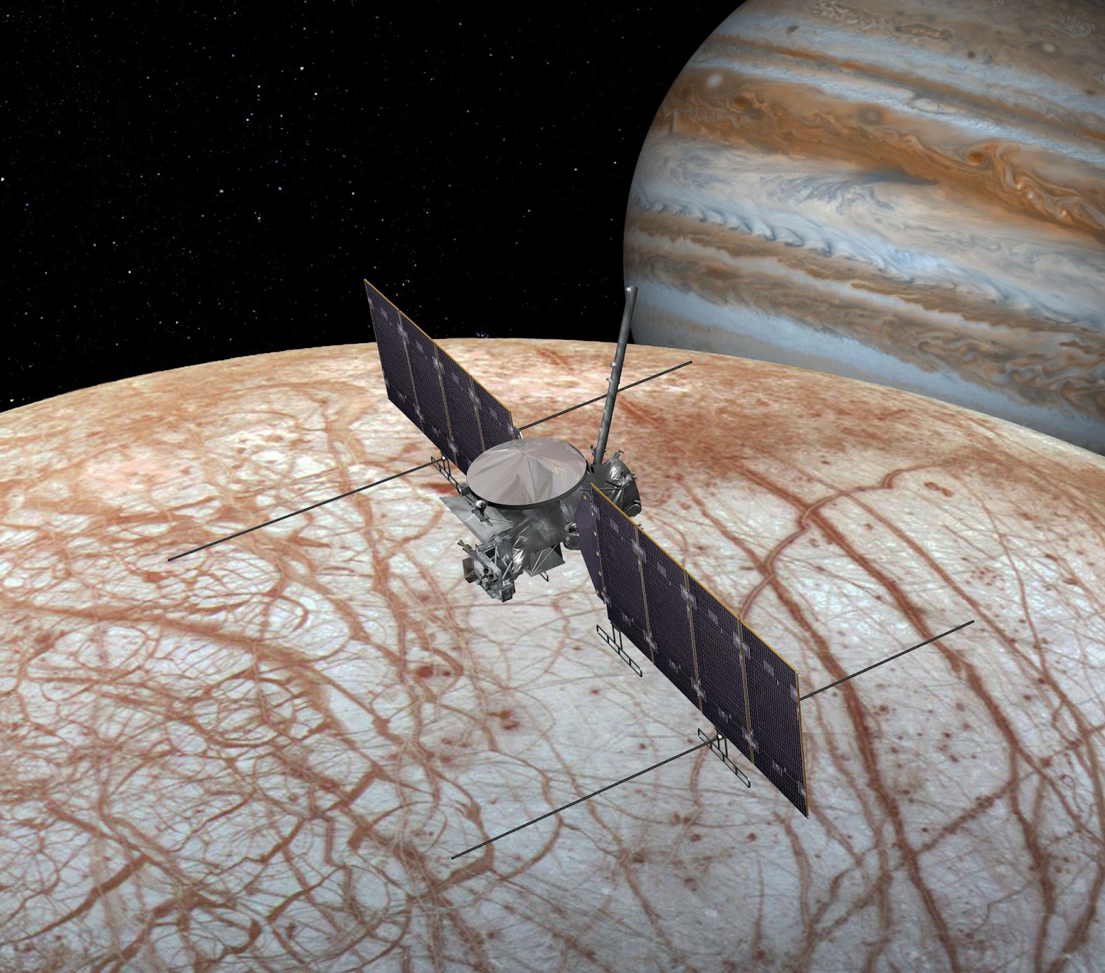
Europa Mission Spacecraft - Artist's Rendering
Image above: This artist's rendering shows NASA's Europa mission spacecraft, the mission would place a spacecraft in orbit around Jupiter in order to perform a detailed investigation of the giant planet's moon Europa -- a world that shows strong evidence for an ocean of liquid water beneath its icy crust and which could host conditions favorable for life. The highly capable, radiation-tolerant spacecraft would enter into a long, looping orbit around Jupiter to perform repeated close flybys of Europa. Image credit: NASA/JPL-Caltech.
Scientists agree that the evidence is quite strong that Europa, which is slightly smaller than Earth’s moon, has a global saltwater ocean beneath its icy crust. This ocean has at least twice as much water as Earth’s oceans. While recent discoveries have shown that many bodies in the solar system either have subsurface oceans now, or may have in the past, Europa is one of only two places where the ocean is understood to be in contact with a rocky seafloor (the other being Saturn's moon Enceladus). This rare circumstance makes Europa one of the highest priority targets in the search for present-day life beyond Earth.
The SDT was tasked with developing a life-detection strategy, a first for a NASA mission since the Mars Viking mission era more than four decades ago. The report makes recommendations on the number and type of science instruments that would be required to confirm if signs of life are present in samples collected from the icy moon's surface.
The team also worked closely with engineers to design a system capable of landing on a surface about which very little is known. Given that Europa has no atmosphere, the team developed a concept that could deliver its science payload to the icy surface without the benefit of technologies like a heat shield or parachutes.
Images above: This mosaic of images includes the most detailed view of the surface of Jupiter's moon Europa obtained by NASA's Galileo mission. The topmost footprint is the highest resolution image taken by Galileo at Europa. It was obtained at an original image scale of 19 feet (6 meters) per pixel. The other seven images in this observation were obtained at a resolution of 38 feet (12 meters) per pixel, thus the mosaic, including the top image, has been projected at the higher image scale. The top image is also provided at its original resolution, as a separate image file. It includes a vertical black line that resulted from missing data that was not transmitted by Galileo. This is the highest resolution view of Europa available until a future mission visits the icy moon. The right side of the image was previously published as PIA01180. Although this data has been publicly available in NASA's Planetary Data System archive for many years, NASA scientists have not previously combined these images into a mosaic for public release. This observation was taken with the sun relatively high in the sky, so most of the brightness variations visible here are due to color differences in the surface material rather than shadows. Bright ridge tops are paired with darker valleys, perhaps due to a process in which small temperature variations allow bright frost to accumulate in slightly colder, higher-elevation locations. Images Credits: NASA/JPL-Caltech.
The concept lander is separate from the solar-powered Europa multiple flyby mission, now in development for launch in the early 2020s. The spacecraft will arrive at Jupiter after a multi-year journey, orbiting the gas giant every two weeks for a series of 45 close flybys of Europa. The multiple flyby mission will investigate Europa’s habitability by mapping its composition, determining the characteristics of the ocean and ice shell, and increasing our understanding of its geology. The mission also will lay the foundation for a future landing by performing detailed reconnaissance using its powerful cameras.
NASA has announced two upcoming town hall meetings to discuss the Science Definition Team report and receive feedback from the science community. The first will be on March 19, in conjunction with the 2017 Lunar and Planetary Science Conference (LPSC) at The Woodlands, Texas. The second event will be on April 23 at the Astrobiology Science Conference (AbSciCon) in Mesa, Arizona.
To read the complete report visit: http://solarsystem.nasa.gov/europa/technical.cfm
Related links:
Mars Viking mission: http://mars.nasa.gov/programmissions/missions/past/viking/
Europa multiple flyby mission: https://www.nasa.gov/press-release/all-systems-go-for-nasas-mission-to-jupiter-moon-europa
2017 Lunar and Planetary Science Conference (LPSC): http://www.hou.usra.edu/meetings/lpsc2017/
Astrobiology Science Conference (AbSciCon): http://www.hou.usra.edu/meetings/abscicon2017/
Europa (Moon): https://www.nasa.gov/subject/3148/europa-moon
Europa Mission: http://www.nasa.gov/europa
Images (mentioned), Text, Credits: NASA/Tricia Talbert.
Greetings, Orbiter.ch
Inscription à :
Articles (Atom)


