vendredi 5 mai 2017
Approaching Jupiter
NASA - JUNO Mission logo.
May 5, 2017
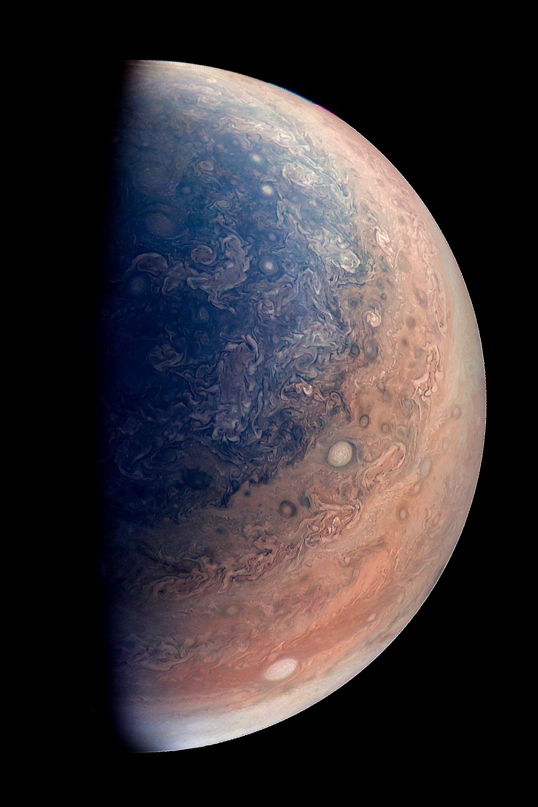
This enhanced color view of Jupiter’s south pole was created by citizen scientist Gabriel Fiset using data from the JunoCam instrument on NASA’s Juno spacecraft. Oval storms dot the cloudscape. Approaching the pole, the organized turbulence of Jupiter’s belts and zones transitions into clusters of unorganized filamentary structures, streams of air that resemble giant tangled strings.
The image was taken on Dec. 11, 2016 at 9:44 a.m. PST (12:44 p.m. EST), from an altitude of about 32,400 miles (52,200 kilometers) above the planet’s beautiful cloud tops.
JunoCam's raw images are available for the public to peruse and process into image products at:
http://www.missionjuno.swri.edu/junocam
More information about Juno is at:
http://www.nasa.gov/juno and http://missionjuno.swri.edu
Image, Text, Credits: NASA/Tony Greicius/JPL-Caltech/SwRI/MSSS/Gabriel Fiset.
Greetings, Orbiter.ch
NASA Rover Samples Active Linear Dune on Mars
NASA - Mars Science Laboratory (MSL) logo.
May 5, 2017
Image above: This self-portrait of NASA's Curiosity Mars rover shows the vehicle at the "Quela" drilling location in the "Murray Buttes" area on lower Mount Sharp (2016). Image Credits: NASA/JPL-Caltech/MSSS.
Key features on the skyline of this panorama are the dark mesa called "M12" to the left of the rover's mast and pale, upper Mount Sharp to the right of the mast. The top of M12 stands about 23 feet (7 meters) above the base of the sloping piles of rocks just behind Curiosity.
As it drives uphill from a band of rippled sand dunes, NASA's Curiosity Mars rover is toting a fistful of dark sand for onboard analysis that will complete the rover's investigation of those dunes.
From early February to early April, the rover examined four sites near a linear dune for comparison with what it found in late 2015 and early 2016 during its investigation of crescent-shaped dunes. This two-phase campaign is the first close-up study of active dunes anywhere other than Earth.
Among the questions this Martian dune campaign is addressing is how winds shape dunes that are relatively close together, on the same side of the same mountain, into different patterns. Others include whether Martian winds sort grains of sand in ways that affect the distribution of mineral compositions, which would have implications for studies of Martian sandstones.
Textures Where Curiosity Rover Studied a Martian Dune
Image above: This view from the Mast Camera (Mastcam) on NASA's Curiosity Mars rover shows two scales of ripples, plus other textures, in an area where the mission examined a linear-shaped dune in the Bagnold dune field on lower Mount Sharp in March and April 2017. Image Credits:NASA/JPL-Caltech/MSSS.
"At these linear dunes, the wind regime is more complicated than at the crescent dunes we studied earlier," said Mathieu Lapotre of Caltech, in Pasadena, California, who helped lead the Curiosity science team's planning for the dune campaign. "There seems to be more contribution from the wind coming down the slope of the mountain here compared with the crescent dunes farther north."
The linear dunes lie uphill and about a mile (about 1.6 kilometers) south from the crescent dunes. Both study locations are part of a dark-sand swath called the Bagnold Dunes, which stretches several miles in length. This dune field lines the northwestern flank of Mount Sharp, the layered mountain that Curiosity is climbing.
"There was another key difference between the first and second phases of our dune campaign, besides the shape of the dunes," Lapotre said. "We were at the crescent dunes during the low-wind season of the Martian year and at the linear dunes during the high-wind season. We got to see a lot more movement of grains and ripples at the linear dunes."
NASA's Curiosity Mars Rover at Ogunquit Beach (360 View)
To assess wind strength and direction, the rover team now uses change-detection pairs of images taken at different times to check for movement of sand grains. The wind-sensing capability of the Curiosity's Rover Environmental Monitoring Station (REMS) is no longer available, though that instrument still returns other Mars-weather data daily, such as temperatures, humidity and pressure. Two of the six wind sensors on the rover's mast were found to be inoperable upon landing on Mars in 2012. The remainder provided wind information throughout the rover's prime mission and first two-year extended mission.
A sample of sand that Curiosity scooped up from a linear dune is in the sample-handling device at the end of the rover's arm. One portion has been analyzed in the Sample Analysis at Mars (SAM) instrument inside the rover. The science team plans to deliver additional sample portions to SAM and to the rover's Chemistry and Mineralogy (CheMin) instrument.
One factor in choosing to drive farther uphill before finishing analysis of the scooped sand is the status of Curiosity's rock-sampling drill, which has not been used on a rock since a problem with the drill feed mechanism appeared five months ago. Engineers are assessing how the use of vibration to deliver samples may affect the drill feed mechanism, which is used to move the drill bit forward and backwards. In addition, high winds at the linear-dunes location were complicating the process of pouring sample material into the entry ports for the laboratory instruments.
Panorama with Active Linear Dune in Gale Crater, Mars
Image above: This 360-degree scene from the Mastcam on NASA's Curiosity Mars rover includes part of a linear-shaped dune the rover examined in early 2017 for comparison with what it found previously at crescent-shaped dunes. Image Credits: NASA/JPL-Caltech/MSSS.
"A balky brake appears to be affecting drill feed mechanism performance," said Curiosity Deputy Project Manager Steven Lee, of NASA's Jet Propulsion Laboratory, Pasadena, California. "In some cases, vibration has been observed to change feed effectiveness, so we're proceeding cautiously until we better understand the behavior. In the meantime, the engineering team is developing several methods to improve feed reliability."
Curiosity landed near Mount Sharp in August 2012. It reached the base of the mountain in 2014 after successfully finding evidence on the surrounding plains that ancient Martian lakes offered conditions that would have been favorable for microbes if Mars has ever hosted life. Rock layers forming the base of Mount Sharp accumulated as sediment within ancient lakes billions of years ago.
On Mount Sharp, Curiosity is investigating how and when the ancient habitable conditions known from the mission's earlier findings evolved into drier conditions that were less favorable for life.
More information about Curiosity is online at http://www.nasa.gov/msl and http://mars.jpl.nasa.gov/msl/.
Images (mentioned), Video, Text, Credits: NASA/Laurie Cantillo/Dwayne Brown/JPL/Guy Webster/Andrew Good/Caltech/Robert Perkins.
Greetings, Orbiter.ch
SolarStratos achieves its first flight
SolarStratos logo.
May 5, 2017
Raphaël Domjan's solar plane was successfully tested on Friday in Payerne AB. Objective: a solar stratospheric flight at more than 24'000 meters.
"This first flight lasted about seven minutes," said Communications Officer Michel Gandillon.
SolarStratos, the solar plane of Raphaël Domjan, made its first flight on Friday morning above Payerne (VD, Switzerland). The test driver Damian Hischier was in command. A very first test of about 6 minutes. The first stratospheric flight is expected in 2019.
"The machine is mounted between 250 and 300 meters. The goal was not to achieve an altitude record, but to make a first flight. So far, everything was limited to a drawing board, "explained to the ats Raphaël Domjan, the initiator of the project.
"Overall, everything went well. Of course, small adjustments, there will be, "added the eco-enthusiast. The debriefing and the detailed analysis of the flight remain to be done. Test flights will continue from next week.
In the stratosphere
Ultimately, by 2019, the objective is to achieve the first solar stratospheric flight at over 24,000 meters, an altitude impossible to reach with a conventional propulsion. The aircraft is 8.5 meters long and 24.8 meters wide. It is covered with 22 square meters of solar panels and weighs 450 kilos.
In June, Raphaël Domjan will present his plane to Montreal, where 130 mayors of the world's largest cities meet. Then the test flights will continue. "We will fly two, then I will take the orders," added Domjan.
With Bertrand Piccard
With his two-seater, he hopes to beat the record of altitude reached by Solar Impulse, the 10'000 meters. And this with Bertrand Piccard on board, perhaps by the end of the year already.
First successful flight for solar plane SolarStratos (in French)
For reasons of weight, the device is not pressurized. To fly in the stratosphere, the pilot must wear a combination of astronaut. "As of next year, we will begin flights in a pressurized suit," Domjan said. The eco-enthusiast recalls that its objective is to promote renewable energies. "In the 20th century, the adventure was realized with fossil energies. In the 21st century, it is written with renewable energies, "he said.
Related articles:
Swiss adventurer unveils incredible stratospheric solar plane
http://orbiterchspacenews.blogspot.ch/2016/12/swiss-adventurer-unveils-incredible.html
Stratospheric flight with a solar plane
http://orbiterchspacenews.blogspot.ch/2014/11/stratospheric-flight-with-solar-plane.html
For more information about SolarStratos, visit: https://www.solarstratos.com/en/
Images, Video, Text, Credits: Revillard/Rezo/SolarStratos/nxp/ats/Le Matin/Orbiter.ch Aerospace/Roland Berga.
Greetings, Orbiter.ch
jeudi 4 mai 2017
Bone Loss Research, DNA Tech on Station Seeks to Improve Health
ISS - Expedition 51 Mission patch.
May 4, 2017
International Space Station (ISS). Animation Credit: NASA
The five-member crew aboard the International Space Station was back at work Thursday researching how living in space affects the human body. Two of today’s experiments looked at how microgravity weakens bones and alters DNA.
Commander Peggy Whitson joined Flight Engineer Thomas Pesquet for the OsteoOmics bone loss study. The experiment compares bone loss in the free-floating environment of microgravity versus magnetic levitation on Earth and observes the molecular changes that place. Results may improve the health of crews in space and humans on Earth, possibly counteracting bone loss and preventing bone diseases.
Image above: Expedition 15 crew members Fyodor Yurchikhin and Jack Fischer take a break during mealtime in the Unity module. Image Credit: NASA.
Pesquet later checked samples for the Genes In Space experiment that is based on a winning proposal submitted during a student science competition. That study is testing new technology to track how a space mission alters an astronaut’s DNA and impacts their immune system.
The rest of the crew, including NASA astronaut Jack Fischer and cosmonauts Fyodor Yurchikhin and Oleg Novitskiy, split their time between loading a Russian cargo craft, crew orientation and systems maintenance.
Related links:
OsteoOmics: https://www.nasa.gov/mission_pages/station/research/experiments/1284.html
Genes In Space: https://www.nasa.gov/mission_pages/station/research/experiments/2437.html
Space Station Research and Technology: https://www.nasa.gov/mission_pages/station/research/index.html
International Space Station (ISS): https://www.nasa.gov/mission_pages/station/main/index.html
Animation (mentioned), Image (mentioned), Text, Credits: NASA/Mark Garcia.
Best regards, Orbiter.ch
AIRS: 15 Years of Seeing What's in the Air
NASA - EOS Aqua Mission logo.
May 4, 2017
Accurate weather forecasts save lives. NASA's Atmospheric Infrared Sounder (AIRS) instrument, launched on this date 15 years ago on NASA’s Aqua satellite, significantly increased weather forecasting accuracy within a couple of years by providing extraordinary three-dimensional maps of clouds, air temperature and water vapor throughout the atmosphere's weather-making layer. Fifteen years later, AIRS continues to be a valuable asset for forecasters worldwide, sending 7 billion observations streaming into forecasting centers every day.
Besides contributing to better forecasts, AIRS maps greenhouse gases, tracks volcanic emissions and smoke from wildfires, measures noxious compounds like ammonia, and indicates regions that may be heading for a drought. Have you been wondering how the ozone hole over Antarctica is healing? AIRS observes that too.
Animation above: A visualization of AIRS measurements of water vapor in a storm near Southern California. AIRS' 3D maps of the atmosphere improve weather forecasts worldwide. Animation Credit: NASA.
These benefits come because AIRS sees many more wavelengths of infrared radiation in the atmosphere, and makes vastly more observations per day, than the observing systems that were previously available. Before AIRS launched, weather balloons provided the most significant weather observations. Previous infrared satellite instruments observed using about two dozen broad “channels" that averaged many wavelengths together. This reduced their ability to detect important vertical structure. Traditional weather balloons produce only a few thousand soundings (atmospheric vertical profiles) of temperature and water vapor a day, almost entirely over land. AIRS observes 100 times more wavelengths than the earlier instruments and produces close to 3 million soundings a day, covering 85 percent of the globe.
AIRS observes 2,378 wavelengths of heat radiation in the air below the satellite. "Having more wavelengths allows us to get finer vertical structure, and that gives us a much sharper picture of the atmosphere," explained AIRS Project Scientist Eric Fetzer of NASA's Jet Propulsion Laboratory in Pasadena, California. Weather occurs in the troposphere, 7 to 12 miles high (11 to 19 kilometers). Most of the infrared radiation observed by AIRS also originates in the troposphere.
AIRS was widely recognized as a great advance very quickly. Only three years after its launch, former National Oceanic and Atmospheric Administration (NOAA) Administrator Conrad Lautenbacher said AIRS provided "the most significant increase in forecast improvement [in our time] of any single instrument."
In the Beginning
AIRS was the brainchild of NASA scientist Moustafa Chahine. In the 1960s, Chahine and colleagues first conceived the idea of improving weather forecasting by using a hyperspectral instrument -- one that breaks infrared and visible radiation into hundreds or thousands of wavelength bands. He flew some experimental prototypes as early as the 1970s, but AIRS did not come to fruition until advances in miniaturization made it possible to build an instrument with the needed capability that wasn't too heavy and bulky to launch. Chahine, who died in 2011, became the first AIRS Science Team leader.
The instrument was built by BAE Systems, now located in Nashua, New Hampshire, under the direction of JPL. It is one of six instruments flying on the Aqua satellite in the A-Train satellite constellation. With a planned mission life of five years, it is still going strong at 15 and is expected to last until Aqua runs out of fuel in 2022.
The value of AIRS to weather forecasting was quantified in several experiments by forecasting centers worldwide. In particular, the European Centre for Medium Range Weather Forecasts (ECMWF) has investigated in detail the impact on forecasts of different observational systems. “ECMWF studies have shown that in many circumstances, AIRS is responsible for reducing forecast errors by more than 10 percent. This is the largest forecast improvement of any single satellite instrument of the 2000s,” said Joao Teixeira of JPL, the AIRS Science Team leader.
Seeing More than Weather
Scientists always knew that AIRS' measurements contained information beyond what meteorologists need for weather forecasting. The spectral wavelengths it sees include parts of the electromagnetic spectrum that are important for studying climate. Carbon dioxide and other atmospheric trace gases leave their signatures in the measurements. Chahine later commented, "The information is all there in the spectra. We just had to figure out how to extract it."
In the mid- to late 2000s, the AIRS project team turned to that challenge. In 2008, under Chahine's leadership, they published the first-ever global satellite maps of carbon dioxide in the mid-troposphere. These measurements showed for the first time that the most important human-produced greenhouse gas was not evenly mixed throughout the global atmosphere, as researchers had thought, but varied by as much as 1 percent (2 to 4 molecules of carbon dioxide out of every million molecules of the atmosphere).
Since then, more and more information has been extracted from the AIRS spectra. The team now also produces data sets for methane, carbon monoxide, ozone, sulfur dioxide and dust, an important influence on how much radiation reaches Earth from the sun and how much escapes from Earth to space. Researchers have used these new data sets, and also the original AIRS temperature, cloud and water data sets, for many discoveries. To name a few recent findings:
• A 2015 study showed that AIRS' measurements of relative humidity near Earth's surface show promise in detecting the onset of drought almost two months ahead of other indicators.
• In 2013, researchers used AIRS' data record to find 18 global hot spots for atmospheric gravity waves -- up-and-down ripples that may form in the atmosphere above something that disturbs air flow, such as a thunderstorm updraft or a mountain range. This new record of where and when disturbances regularly create gravity waves is valuable for improving weather and climate forecasts.
• Global warming increases the amount of water vapor in the atmosphere, which in turn warms the atmosphere even further. This kind of self-feeding process is called a positive feedback loop. Climate scientists had long theorized that this feedback might double the warming from increases in carbon dioxide. AIRS' temperature and humidity data allowed them to confirm this hypothesis for the first time.
NASA’s Aqua satellite. Image Credit: NASA
AIRS' Legacy
Due to its resounding success, AIRS is no longer one of a kind. "The mission has demonstrated a measurement approach that will be used by operational agencies for the foreseeable future," said AIRS Project Manager Tom Pagano of JPL. Already, there are three other hyperspectral sounders in orbit: the Cross-track Infrared Sounder (CrIS) on the NASA/NOAA Suomi National Polar-orbiting Partnership (Suomi-NPP), and two Infrared Atmospheric Sounding Interferometer (IASI) instruments on EUMETSAT's Metop-A and -B satellites. Additional sounders are planned for launch into the 2030s.
Together, these hyperspectral instruments will create a record of highly accurate measurements of our atmosphere that will be many decades long. That will add one more benefit to AIRS' legacy: the potential for improving understanding of the climate of today and the future.
Related links:
NASA's Atmospheric Infrared Sounder (AIRS): https://www.nasa.gov/subject/3126/air
NASA’s Aqua satellite: https://www.nasa.gov/mission_pages/aqua/index.html
Image (mentioned), Animation (mentioned), Text, Credits: NASA's Earth Science News Team, written by Carol Rasmussen/Tony Greicius/JPL/Alan Buis.
Greetings, Orbiter.ch
Successfully Liftoff of Arianespace’s Ariane 5 with SGDC and KOREASAT-7
ARIANESPACE - Ariane 5 ECA / Flight VA236 Mission poster.
May 4, 2017
Arianespace Ariane 5 ECA Launch SGDC & Koreasat 7 (Illustration)
Arianespace has successfully launched two telecommunications satellites: SGDC for Visiona Tecnologia Espacial S.A, on behalf of the Brazilian operator Telebras S.A. and the Brazilian government; and KOREASAT-7 for South Korean operator ktsat.
Liftoff of Arianespace’s Ariane 5 with SGDC and KOREASAT-7
The launch took place on Tuesday, May 4 at 6:50 pm (local time, 20:50 UTC) from the Guiana Space Center, Europe’s Spaceport in Kourou, French Guiana.
Image above: Ariane 5 moves into position at the Spaceport’s ELA-3 launch zone. Flight VA236. SGDC and KOREASAT-7.
For its fourth launch of the year, and the second Ariane 5 mission in 2017 from the Guiana Space Center in French Guiana, Arianespace will orbit two satellites: SGDC for VISIONA Tecnologia Espacial S.A. on behalf of the Brazilian operator Telebras S.A., and KOREASAT-7 for ktsat of South Korea.
Image above: SGDC (Geostationary Satellite for Communications and Defense) is the first satellite for the operator Telebras S.A.
SGDC (Geostationary Satellite for Communications and Defense) is the first satellite for the operator Telebras S.A. to be launched by Arianespace, performed within the scope of a contract with SGDC prime contractor VISIONA Tecnologia Espacial S.A.
This Brazilian government program has three main objectives:
- Reduce Brazil’s digital divide by providing high-quality Internet services to 100% of the country territory as part of the National Broadband Plan
- Provide sovereign and secure means for the Brazilian Government and Defense strategic communications
- Acquire critical technologies for the Brazilian space industry, enabling the industry to take increasingly important roles in the future Brazilian space programs.
KOREASAT-7 satellite
KOREASAT-7 is the third KOREASAT satellite to be launched by Arianespace for ktsat, following KOREASAT-3 and KOREASAT-6, launched in September 1999 and December 2010, respectively.
ktsat, a wholly-owned subsidiary of KT Corp. – the largest telecom/media service provider in South Korea – is the country’s sole satellite service provider. Since the establishment of the Kumsan Satellite Center (Teleport) in 1970, ktsat has been the national leader in telecommunications and broadcasting services. It currently operates three satellites.
KOREASAT-7 will provide a full range of video and data applications, including Internet access, direct-to-home broadcasting (DTH), government communications and connectivity for VSAT (Very Small Aperture Terminal) networks.
SGDC and KOREASAT-7 are the 555th and 556th satellites to be launched by Arianespace.
This will be the 287th mission by the Arianespace family of launchers, and the seventh all-Thales Alenia Space mission, as both satellites were built by this manufacturer.
For more information about ARIANESPACE, visit: http://www.arianespace.com/
Images, Video, Text, Credits: ARIANESPACE/VISIONA Tecnologia Espacial S.A./KT Corp.
Best regards, Orbiter.ch
Are Star Wars Planets Real?
NASA - Kepler Space Telescope patch.
May 4, 2017
Illustration of an Earth-Sized 'Tatooine' Planet
With two suns in its sky, Luke Skywalker's home planet Tatooine in "Star Wars" looks like a parched, sandy desert world. In real life, thanks to observatories such as NASA's Kepler space telescope, we know that two-star systems can indeed support planets, although planets discovered so far around double-star systems are large and gaseous. Scientists wondered: If an Earth-size planet were orbiting two suns, could it support life?
It turns out, such a planet could be quite hospitable if located at the right distance from its two stars, and wouldn't necessarily even have deserts. In a particular range of distances from two sun-like host stars, a planet covered in water would remain habitable and retain its water for a long time, according to an April 6, 2017 study in the journal Nature Communications.
Kepler Space Telescope or K2
This illustration shows a hypothetical planet covered in water around the binary star system of Kepler-35A and B. In reality, the stellar pair Kepler-35A and B host a planet called Kepler-35b, a giant planet about eight times the size of Earth, with an orbit of 131.5 Earth days. For their study, researchers neglected the gravitational influence of this planet and added a hypothetical water-covered, Earth-size planet around the Kepler-35 A and B stars. They examined how this planet’s climate would behave as it orbited the host stars with periods between 341 and 380 days.
Planets With Two Suns
From Luke Skywalker’s home world Tatooine, you can stand in the orange glow of a double sunset. The same could said for Kepler-16b, a cold gas giant roughly the size of Saturn, that orbits two stars. Kepler-16b was the Kepler telescopes’s first discovery of a planet in a “circumbinary” orbit (that is, circling both stars, as opposed to just one, in a double star system).
The best part is that Tatooine aka Kepler-16b was just the first. It has family. A LOT of family. Half the stars in our galaxy are pairs, rather than single stars like our sun. If every star has at least one planet, that’s billions of worlds with two suns. Billions! Maybe waiting for life to be found on them.
Desert Worlds
Mars is a cold desert planet in our solar system, and we have plenty of examples of scorching hot planets in our galaxy (like Kepler-10b), which orbits its star in less than a day)! Scientists think that if there are other habitable planets in the galaxy, they’re more likely to be desert planets than ocean worlds. That’s because ocean worlds freeze when they’re too far from their star, or boil off their water if they’re too close, potentially making them unlivable. Perhaps, it’s not so weird that both Luke Skywalker and Rey grew up on planets that look a lot alike.
Ice Planets
An icy super-Earth named OGLE-200-BLG-390Lb reminded scientists so much of the frozen Rebel base they nicknamed it “Hoth,” after its frozen temperature of minus 364 degrees Fahrenheit.
Another Hoth-like planet was discovered last month; an Earth-mass icy world orbiting its star at the same distance as Earth orbits the sun. But its star is so faint, the surface of OGLE-2016-BLG-1195Lb is probably colder than Pluto.
Forest worlds
Both the forest moon of Endor and Takodana, the home of Han Solo’s favorite cantina in “Force Awakens,” are green like our home planet. But astrobiologists think that plant life on other worlds could be red, black, or even rainbow-colored!
In February 2017, the Spitzer Space Telescope discovered seven Earth-sized planets in the same system, orbiting the tiny red star TRAPPIST-1.
TRAPPIST-1 system
The light from a red star, also known as an M dwarf, is dim and mostly in the infrared spectrum (as opposed to the visible spectrum we see with our sun). And that could mean plants with wildly different colors than what we’re used to seeing on Earth. Or, it could mean animals that see in the near-infrared.
"You don’t need to visit a galaxy far, far away to find wondrous worlds. Just visit this one … there’s plenty to see."
More: Earth-Sized 'Tatooine' Planets Could Be Habitable: https://www.nasa.gov/feature/jpl/earth-sized-tatooine-planets-could-be-habitable
Related article:
Ultracool Dwarf and the Seven Planets
http://orbiterchspacenews.blogspot.ch/2017/02/ultracool-dwarf-and-seven-planets.html
Related links:
Exoplanets: https://www.nasa.gov/content/the-search-for-life
NASA's Kepler space telescope: https://www.nasa.gov/mission_pages/kepler/main/index.html
Images, Animations, Text, Credits: NASA/Sarah Loff/JPL-Caltech.
Greetings, Orbiter.ch
Inscription à :
Articles (Atom)