vendredi 11 octobre 2019

Second of Five Power Upgrade Spacewalks Wraps Up


ISS - Expedition 61 Mission patch / EVA - Extra Vehicular Activities patch.

October 11, 2019

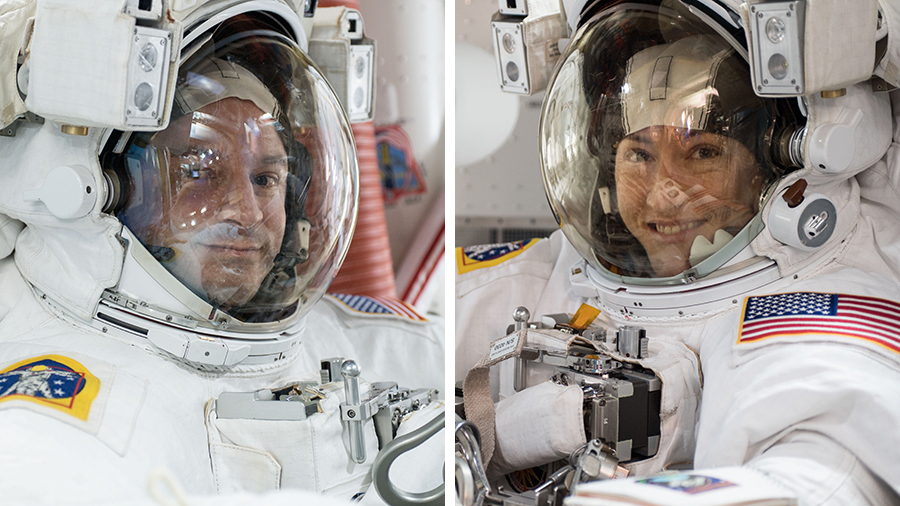
Expedition 61 Flight Engineers Christina Koch and Andrew Morgan of NASA concluded their spacewalk at the International Space Station at 2:23 p.m. EDT. During six-hour and 45-minute spacewalk, the two NASA astronauts continued the replacement of nickel-hydrogen batteries with newer, more powerful lithium-ion batteries on the far end of the station’s port truss.

Astronauts also were able to accomplish several get-ahead tasks setting up for the next spacewalk.


Image above: Astronauts Andrew Morgan and Christina Koch are pictured in their U.S. spacesuits during a spacewalk earlier this year. Image above:

These new batteries provide an improved power capacity for operations with a lighter mass and a smaller volume than the nickel-hydrogen batteries. On Oct. 16, Morgan and NASA astronaut Jessica Meir are scheduled to venture outside for another spacewalk to continue the battery replacements on the first of the two power channels for the station’s far port truss. The following spacewalks dedicated to the battery upgrades are scheduled on Oct. 21 and 25.

October 11, 2019 spacewalk. Image Credit: NASA TV

After completion of the battery spacewalks, the second half of this sequence of spacewalks will focus on repairs to the space station’s Alpha Magnetic Spectrometer. Dates for those spacewalks still are being discussed, but they are expected to begin in November.

Space station crew members have conducted 220 spacewalks in support of assembly and maintenance of the orbiting laboratory. Spacewalkers have now spent a total of 57 days 13 hours and 12 minutes working outside the station.

Related links:

Expedition 61: https://www.nasa.gov/mission_pages/station/expeditions/expedition61/index.html

Alpha Magnetic Spectrometer (AMS): https://www.nasa.gov/feature/extending-science-in-the-search-for-the-origin-of-the-cosmos

Space Station Research and Technology: https://www.nasa.gov/mission_pages/station/research/index.html

International Space Station (ISS): https://www.nasa.gov/mission_pages/station/main/index.html

Images (mentioned), Text, Credits: NASA/Norah Moran.

Best regards, Orbiter.ch

Space Station Science Highlights: Week of October 7, 2019


ISS - Expedition 61 Mission patch.

Oct. 11, 2019

While it was a week full of spacewalks, the crew aboard the International Space Station fit in some science during the week of Oct. 7. In addition to prepping for a series of battery Extravehicular Activities (EVAs), research conducted included collecting air quality samples, watering veggies and recharging free-flying robot assistants. Research like this conducted aboard the space station is a crucial stepping stone for Artemis, NASA’s plans to go forward to the Moon and on to Mars.


Image above: NASA astronaut Andrew Morgan takes an out-of-this-world "space-selfie" during a spacewalk to upgrade space station power systems on the Port-6 (P6) truss structure. He and fellow NASA astronaut Christina Koch (out of frame) worked for about seven hours to begin the latest round of upgrading the station's large nickel-hydrogen batteries with newer, more powerful lithium-ion batteries. Image Credit: NASA.

Here are details on some of the science conducted on the orbiting laboratory during the week:

Checking out the air

This past week, the crew helped collect samples for the Spacecraft Atmosphere Monitor (S.A.M.). One of the most important conditions associated with crew health during spaceflight is air quality. Currently, atmosphere quality aboard the space station is assessed by periodic sampling and ground-based analysis using sophisticated instruments. Since samples cannot be returned to Earth during future exploration missions, a complement of smaller and more reliable instruments such as S.A.M. becomes essential to monitor the crew environment.

It’s planting season


Image above: NASA astronaut Christina Koch checks progress on small plant pillows for the Veg-04B investigation. Veg-04B focuses on the effects of light quality and fertilizer on the leafy Mizuna mustard green crop, microbial food safety, nutritional value and the taste acceptability by the crew. Image Credit: NASA.

Watering crops on the space station is a bit different than on Earth. Rather than pouring water onto soil, the crew injected water to small plant pillows that provide needed water to the growing veggies. This is part of Veg-04B, one piece of a phased research project attempting to address the need for a continuous fresh-food production system in space to supplement typical pre-packaged foods for astronauts. Veg-04B focuses on the effects of light quality and fertilizer on the leafy Mizuna mustard green crop, microbial food safety, nutritional value and the taste acceptability by the crew.


Image above: NASA astronaut Andrew Morgan reviews procedures the day before the EVA that took place on Oct. 6 to upgrade the space station’s batteries. Image Credit: NASA.

Getting charged up

The free-flying robot facility known as Astrobee got its batteries charged up this week. The facility is designed to help scientists and engineers develop and test technologies that can assist astronauts with routine chores and give ground controllers additional eyes and ears on the space station. The autonomous robots, powered by fans and vision-based navigation, perform crew monitoring and sampling and logistics management. The robots accommodate up to three investigations.


Animation above: NASA astronaut Christina Koch spins a Grab Sample Container, a device that is used for collecting environmental samples for the Spacecraft Atmosphere Monitor.
Image Credit: NASA.

Other investigations on which the crew performed work:

- The brain is capable of self-regulating blood flow even when the heart and blood vessels cannot maintain an ideal blood pressure. The Cerebral Autoregulation investigation tests whether this self-regulation improves in the microgravity environment of space.
https://www.nasa.gov/mission_pages/station/research/experiments/explorer/Investigation.html?#id=1938

- The Food Physiology experiment is designed to characterize the key effects of an enhanced spaceflight diet on immune function, the gut microbiome and nutritional status indicators.
https://www.nasa.gov/mission_pages/station/research/experiments/explorer/Investigation.html?#id=7870

- Actiwatch is a nonintrusive, wearable monitor that analyzes a crew member’s circadian rhythms, sleep-wake patterns and activity.
https://www.nasa.gov/mission_pages/station/research/experiments/explorer/Facility.html?#id=838

- ISS Ham Radio provides students, teachers, parents and other members of the community an opportunity to communicate directly with astronauts using Ham radio units.
https://www.nasa.gov/mission_pages/station/research/experiments/explorer/Investigation.html?#id=337

- Food Acceptability examines changes in the appeal of food aboard the space station during long-duration missions. “Menu fatigue” from repeatedly consuming a limited choice of foods may contribute to the loss of body mass often experienced by crew members, potentially affecting astronaut health, especially as mission length increases.
https://www.nasa.gov/mission_pages/station/research/experiments/explorer/Investigation.html?#id=7562

- The Microgravity Crystals investigation crystallizes a membrane protein that is integral to tumor growth and cancer survival. Results may support development of cancer treatments that target the protein more effectively and with fewer side effects.
https://www.nasa.gov/mission_pages/station/research/experiments/explorer/Investigation.html?#id=7977

- BEST studies the use of DNA sequencing to identify unknown microbial organisms and improve understanding of how humans, plants and microbes adapt to living in space.
https://www.nasa.gov/mission_pages/station/research/experiments/explorer/Investigation.html?#id=7687

Related links:

Expedition 61: https://www.nasa.gov/mission_pages/station/expeditions/expedition61/index.html

Artemis: https://www.nasa.gov/artemis

Spacecraft Atmosphere Monitor (S.A.M.): https://www.nasa.gov/mission_pages/station/research/experiments/explorer/Investigation.html?#id=1843

Veg-04B: http://www.nasa.gov/mission_pages/station/research/experiments/explorer/Investigation.html?#id=7895

Astrobee: https://www.nasa.gov/mission_pages/station/research/experiments/explorer/Facility.html?#id=1891

ISS National Lab: https://www.issnationallab.org/

Spot the Station: https://spotthestation.nasa.gov/

Space Station Research and Technology: https://www.nasa.gov/mission_pages/station/research/index.html

International Space Station (ISS): https://www.nasa.gov/mission_pages/station/main/index.html

Images (mentioned), Animation (mentioned), Text, Credits: NASA/Michael Johnson/John Love, Lead Increment Scientist Expedition 61.

Best regards, Orbiter.ch

Celebrating a Mission That Changed How We Use Radar


NASA - STS-59 Mission patch.

October 11, 2019

Oct. 11, 2019, marks the 25th anniversary of the end of a space mission that transformed the way we use radar to observe large-scale environmental processes on our home planet. The Spaceborne Imaging Radar-C and X-Band Synthetic Aperture Radar (SIR-C/X-SAR) mission made available to people worldwide the scientific data used to this day to inform decisions to slow and mitigate climate change.

The SIR-C instrument, built by NASA'S Jet Propulsion Laborator in Pasadena, California, and the X-SAR instrument, built by the German Aerospace Center (DLR), constituted the most advanced imaging radar system ever used in air or space. During hundreds of orbits on two flights aboard the Space Shuttle Endeavour, in April and October 1994, the radar system made multiple passes over 19 "supersites" - areas of scientific interest in such locations as the Sahara, Brazil, the Alps and the Gulf Stream. It also imaged events occurring during the flights, such as as a volcano erupting in Russia.


Image above: With SIR-C/X-SAR instruments mounted in the cargo bay atop the shuttle, the Endeavour crew flew upside down, using precise navigation, the hinge on the X-band antenna and "electronic steering" in the C- and L-band antennas to point the radars at "supersites" of scientific interest on Earth. Image Credits: NASA/JPL-Caltech.

"The many innovationsof SIR-C/X-SAR have been used in virtually every air- and spaceborne radar mission since, starting with NASA's Shuttle Radar Topography Mission, which mapped 80% of the Earth in 2000," said Tony Freeman, now manager of JPL's Innovation Foundry, who led end-to-end calibration of SIR-C. "DLR's TerraSAR-X and TanDEM-X missions have since filled remaining gaps."

Radar imaging of Earth has never been the same since SIR-C/X-SAR's demonstration of what's known as simultaneous multifrequency, fully polarized, repeat-pass interferometric SAR. To unpack that sizable trunk of terminology, let's start with "synthetic aperture radar": Since the late 1970s, NASA has been imaging Earth with radar - in darkness, under cloud cover or vegetation, even underground - using the movements of a host airplane or spacecraft to "synthesize" an "aperture" much larger than the antenna itself. The larger the aperture, the greater the image resolution. Indeed, SIR-C's predecessors, SIR-A and SIR-B, were synthetic aperture radar missions.

However, unlike SIR-C/X-SAR, neither predecessor made radar observations simultaneously in three frequencies - C-, L- and X-band - using three adjacent antennas combined into a massive, 12-by-4-meter, 11.5-ton structure. That advance, analogous to the leap from black-and-white to color film, allowed the mission to collect data in different scales, providing a crisp snapshot of each targeted feature, unmuddied by possible changes over time.

Blazing a Trail

In addition to multiple frequencies, some observations were made in multiple "polarizations." Radio frequency waves can be either horizontal (in a wavy plane parallel to the ground) or vertical (in a plane perpendicular to the ground). The C- and L-band antennas could send and receive waves of both horizontal and vertical polarization. Using this "fully polarized" data, scientists can separate out the scattering of radar waves to distinguish, for example, vegetated from unvegetated terrain.

SIR-C/X-SAR wanted to capture changes over time; that's why it flew on shuttle flights six months apart. To observe the same supersites during both flights and to make consistent daily passes over them, the shuttle crew used sophisticated algorithms to navigate the spacecraft in precise orbits as close as 10 meters apart. And they did this flying upside down, since the cargo bay holding the instruments was on top of the shuttle. While the X-band antenna had a hinge, the C- and L-band antennas were fixed at a particular angle, but they had "electronic steering" that allowed them to "see" to either side of what was right in front of them.

Those repeated, slightly offset passes over the same terrain were essential for the data-processing technique of interferometry. Combining views, interferometry creates detailed, 3D topographical images of a target at the moment of simultaneous observations. And it can reveal even minute changes in the target between successive observations - like the gradual creep of an earthquake fault or the movement of an ice sheet.


Image above: These ancient river channels, invisible to the human eye beneath the deep, dry sand of the Sahara Desert, were revealed for the first time by SIR-C/X-SAR instruments during their second shuttle flight in October 1994. Image Credits: NASA/JPL-Caltech.

The SIR-C/X-SAR dataset proved immediately useful, revealing, for instance, ancient riverbeds beneath the Sahara - an artifact of preindustrial climate change - and remains in high demand.

"SIR-C/X-SAR was the path opener for multiple U.S. and international missions that followed," said Charles Elachi, the mission's principal investigator before he became director of JPL. "Imaging of subsurface river channels in the Eastern Sahara enabled new understanding of the environmental history of that and other arid regions. Using multiple frequencies enabled for the first time 'color' radar images that have been used extensively to map vegetation and forests and extract their vegetation content. Using repeat-pass interferometry enabled us for the first time to map surface motion at the centimeter level. This technique is now commonly used to map motions resulting from earthquakes, volcanic eruptions and other natural disasters."

Freeman agrees: "SIR-C/X-SAR was innovative on so many fronts: We knew what we were working on was something special, but we didn't know at the time how many firsts the mission would rack up".

The NASA Image and Video Library makes mission data available to researchers worldwide. The University of Michigan hosts a search tool for accessing its own vast SIR-C/X-SAR database. And in its MapReady tool the University of Alaska Satellite Facility has processed the data for compatibility with multiple computer platforms.

Missions using technologies pioneered by SIR-C/X-SAR have revealed changes in Earth's natural features over increasingly meaningful periods, informing long-term policy to prevent and mitigate climate change. At the same time, they reveal the immediate effects of natural disasters rapidly enough to advise first responders.


Image above: Using the technique of interferometric SAR first demonstrated on SIR-C/X-SAR, four international space agencies cooperated to combine many years' worth of radar observations over the Greenland ice sheet to map its depth and accelerating speed of loss. Image Credits: Courtesy of NASA/GSFC/Jefferson Beck.

SIR-C/X-SAR was a collaboration of NASA, DLR and the Italian Space Agency (ASI), which contributed to the ground segment for X-SAR observations. JPL managed the mission for NASA. DLR was responsible for calibration, operations and data processing for X-SAR.

Related links:

NASA Image and Video Library: https://images.nasa.gov/

MapReady: https://www.asf.alaska.edu/data-tools/mapready/

Images (mentioned), Text, Credits: NASA/JPL/Matthew Segal.

Greetings, Orbiter.ch

Alexei Leonov, the first spacewalker is dead


Rest In Peace.

Oct. 11, 2019

Alexei Leonov, released in space in 1965, died on Friday at the age of 85.

Cosmonaut Alexei Leonov, the first spacewalker

Soviet cosmonaut Alexei Leonov died Friday at the age of 85. He was the first man to make a spacewalk in 1965 and, ten years later, commanded the first joint space mission of the USSR and the United States.

On March 19, 1965, Alexei Leonov made his first outing from his ship Voskhod-2 in the open space, earning him the nickname of first "pedestrian of space". He had cautiously departed two to three meters from the ship, finding the operation very painful.

First spacewalk, Alexey Leonov, March 18, 1965

Blinded by the Sun, despite his golden visor, he was held securely by a cable at the airlock of his ship. "Here, I try," he said, leaving. The operation lasted twenty minutes, twelve minutes entirely outside the Voskhod.

Long illness

The cosmonaut was also the Soviet side commander of the Apollo-Soyuz mission in 1975, the first joint between the two rivals of the Cold War and the space race. This mission marked the beginning of a technological cooperation that continues today.

The cosmonaut was also a close friend of his compatriot Yuri Gagarin, the first man in space. When he died in a plane crash on March 27, 1968 near Moscow, he was one of the first on the scene.

Alexei Leonov died "after a long illness," his collaborator Natalia Filimonova told AFP. His funeral is scheduled for Tuesday in Moscow, announced the Cosmonaut Preparation Center.

Alexey Leonov - Wikipedia: https://en.wikipedia.org/wiki/Alexei_Leonov

Image, Video, Text, Credits: ROSCOSMOS/AFP/Orbiter.ch Aerospace/Roland Berga.

R.I.P.; Orbiter.ch

Northrop Grumman Pegasus XL launches ICON


NASA - Ionospheric Connection Explorer (ICON) logo.

11 oct. 2019

L-1011 Stargazer aircraft and Pegasus XL rocket

A Pegasus XL rocket launched NASA’s Ionospheric Connection Explorer (ICON) on 11 October 2019, at 02:00 UTC. The Northrop Grumman L-1011 Stargazer aircraft took off from the Skid Strip runway at Cape Canaveral Air Force Station in Florida. ICON will explore the ionosphere, the dynamic region where Earth meets space.

Pegasus XL launches ICON (Ionospheric Connection Explorer)

ICON will study the ionosphere, a region of Earth’s upper atmosphere where terrestrial weather meets space weather. Disturbances in the ionosphere triggered by solar storms or weather activity in the lower atmosphere can cause disturbances in GPS navigation and radio transmissions.

Ionospheric Connection Explorer (ICON)

The mission’s staging point was changed from Kwajalein Atoll to Cape Canaveral Air Force Station in mid-2018. Delayed from June 15, Nov. 14, and Dec. 8, 2017. Delayed from June 14, Sept. 24, Oct. 6, Oct. 26 and Nov. 3. Scrubbed on Nov. 7. Delayed from 1st Quarter 2019. Delayed from Oct. 9 by poor weather.

NASA’s Ionospheric Connection Explorer (ICON): https://www.nasa.gov/icon

Images, Video, Text, Credits: NASA/Randy Beaudoin/Ben Smegelsky/USAF 30th SCS/Anthony Vauclin/Northrop Grumman/SciNews/Orbiter.ch Aerospace/Roland Berga.

Greetings, Orbiter.ch

An American astronaut decorated by Vladimir Putin


Order of  Lenin medal.

Oct. 11, 2019

Rescued from the Soyuz rocket accident in October 2018, astronaut Nick Hague has received from the Russian president a prestigious distinction for his courage.

Soyuz MS-10 launch failure

Russian President Vladimir Putin has awarded the Order of Courage, one of the highest honors of the country, to an American astronaut. He had survived a year ago the failed takeoff of a Soyuz rocket.

According to a presidential decree published on Tuesday, the American Nick Hague, 44, is rewarded for "his courage and his high degree of professionalism" in perilous conditions during the launch at the Russian cosmodrome of Baikonur, located in Kazakhstan.


On October 11, 2018, the "Soyuz" rocket in which Nick Hague had sailed and the Russian Alexey Ovchinin had disintegrated minutes after taking off for the International Space Station (ISS), an unprecedented accident for the Russian space program since the end of the USSR.

After being successfully ejected by the automatic rescue system, the two men were released unscathed despite the very strong pressure. "It was a quick flight," commented Alexei Ovchinin, laconic, moments after the start of the incident. According to NASA, "launcher failure" occurred after 119 seconds of travel, while the rocket was launched at over 7500 km / h.


In March, they returned successfully to the ISS, where they returned last week after a six-month mission. It was the first space stay for Nick Hague, and the second for Alexey Ovchinin.

Considered one of the highest Russian distinctions, the Order of Courage is often awarded posthumously.

The International Space Station is one of the latest examples of active cooperation between Russia and the United States in a context of unprecedented tensions since the Cold War.

Related articles:

Crew in Good Condition After Booster Failure
https://orbiterchspacenews.blogspot.com/2018/10/crew-in-good-condition-after-booster.html

Soyuz MS-10 - Emergency landing after a failure
https://orbiterchspacenews.blogspot.com/2018/10/soyuz-ms-10-emergency-landing-after.html

Images, Video, Text, Credits: ATS / NASA / ROSCOSMOS / SciNews / Orbiter.ch Aerospace / Roland Berga.

Best regards, Orbiter.ch

ILS - Proton-M launches EUTELSAT 5 West B & MEV-1


ILS - Proton-M / EUTELSAT 5 West B & MEV-1 poster.

Oct. 11, 2019

Proton-M carrying EUTELSAT 5 West B & MEV-1 lift off

An International Launch Services (ILS) Proton-M launch vehicle, with a Briz-M upper stage (Breeze M), launched the EUTELSAT 5 West B communications satellite and Mission Extension Vehicle-1 (MEV-1) from the Baikonur Cosmodrome in Kazakhstan, on 9 October 2019, at 10:17 UTC (16:17 local time). EUTELSAT 5 West B (2864 kg)  is a Ku-band satellite to be located at 5° West.

Proton-M launches EUTELSAT 5 West B & MEV-1

Build by Northrop Grumman, MEV-1 (2326 kg) will provide satellite life-extension service by docking to the client’s vehicles in geosynchronous orbit to provide attitude and orbit control. MEV-1 will extend the life of the Intelsat 901 satellite for five years.

Eutelsat 5 West B

Both spacecraft are built by Northrop Grumman Innovation Systems, formerly known as Orbital ATK. Eutelsat 5 West B will join Eutelsat’s communications fleet in geostationary orbit, replacing the Eutelsat 5 West A spacecraft providing digital and television services primarily in the French, Italian and Algerian markets.

MEV 1

The MEV 1 spacecraft is the first in a series of satellite servicing vehicles for SpaceLogistics, a subsidiary of Northrop Grumman Innovation Systems. MEV 1 will dock with the Intelsat 901 communications satellite and provide propulsion and attitude control functions to extend the spacecraft’s mission.

Related links:

International Launch Services (ILS): http://www.ilslaunch.com/

Eutelsat: https://www.eutelsat.com/en/home.html

Images, Video, Text, Credits: ILS/SciNews/Orbiter.ch Aerospace/Roland Berga.

Greetings, Orbiter.ch