mardi 3 novembre 2020

NASA’s OSIRIS-REx Successfully Stows Sample of Asteroid Bennu


NASA - OSIRIS-REx Mission patch.


Nov. 3, 2020

NASA’s Origins, Spectral Interpretation, Resource Identification, Security, Regolith Explorer (OSIRIS-REx) mission has successfully stowed the spacecraft’s Sample Return Capsule (SRC) and its abundant sample of asteroid Bennu. On Wednesday, Oct. 28, the mission team sent commands to the spacecraft, instructing it to close the capsule – marking the end of one of the most challenging phases of the mission.

“This achievement by OSIRIS-REx on behalf of NASA and the world has lifted our vision to the higher things we can achieve together, as teams and nations,” said NASA Administrator Jim Bridenstine. “Together a team comprising industry, academia and international partners, and a talented and diverse team of NASA employees with all types of expertise, has put us on course to vastly increase our collection on Earth of samples from space. Samples like this are going to transform what we know about our universe and ourselves, which is at the base of all NASA’s endeavors.”


Image above: The left image shows the OSIRIS-REx collector head hovering over the Sample Return Capsule (SRC) after the Touch-And-Go Sample Acquisition Mechanism arm moved it into the proper position for capture. The right image shows the collector head secured onto the capture ring in the SRC. Both images were captured by the StowCam camera. Image Credits: NASA/Goddard/University of Arizona/Lockheed Martin.

The mission team spent two days working around the clock to carry out the stowage procedure, with preparations for the stowage event beginning Oct. 24. The process to stow the sample is unique compared to other spacecraft operations and required the team’s continuous oversight and input over the two-day period. For the spacecraft to proceed with each step in the stowage sequence, the team had to assess images and telemetry from the previous step to confirm the operation was successful and the spacecraft was ready to continue. Given that OSIRIS-REx is currently more than 205 million miles (330 million km) from Earth, this required the team to also work with a greater than 18.5-minute time delay for signals traveling in each direction.

Throughout the process, the OSIRIS-REx team continually assessed the Touch-And-Go Sample Acquisition Mechanism’s (TAGSAM) wrist alignment to ensure the collector head was being placed properly into the SRC. Additionally, the team inspected images to observe any material escaping from the collector head to confirm that no particles would hinder the stowage process. StowCam images of the stowage sequence show that a few particles escaped during the stowage procedure, but the team is confident that a plentiful amount of material remains inside of the head.

“Given the complexity of the process to place the sample collector head onto the capture ring, we expected that it would take a few attempts to get it in the perfect position,” said Rich Burns, OSIRIS-REx project manager at NASA's Goddard Space Flight Center in Greenbelt, Maryland. “Fortunately, the head was captured on the first try, which allowed us to expeditiously execute the stow procedure.”

By the evening of Oct. 27, the spacecraft’s TAGSAM arm had placed the collector head into the SRC. The following morning, the OSIRIS-REx team verified that the collector head was thoroughly fastened into the capsule by performing a “backout check.” This sequence commanded the TAGSAM arm to attempt to back out of the capsule – which tugged on the collector head and ensured the latches are well secured.

OSIRIS-REx successfully stows sample of Asteroid Bennu

“I want to thank the OSIRIS-REx team from the University of Arizona, NASA Goddard, Lockheed Martin, and their partners, and also especially the SCaN and Deep Space Network people at NASA and JPL, who worked tirelessly to get us the bandwidth we needed to achieve this milestone, early and while still hundreds of millions of miles away,” said Thomas Zurbuchen, NASA’s associate administrator for science at the agency’s headquarters in Washington. “What we have done is a real first for NASA, and we will benefit for decades by what we have been able to achieve at Bennu.”

On the afternoon of Oct. 28, following the backout check, the mission team sent commands to disconnect the two mechanical parts on the TAGSAM arm that connect the sampler head to the arm. The spacecraft first cut the tube that carried the nitrogen gas that stirred up the sample through the TAGSAM head during sample collection, and then separated the collector head from the TAGSAM arm itself.

That evening, the spacecraft completed the final step of the sample stowage process  –closing the SRC. To secure the capsule, the spacecraft closed the lid and then fastened two internal latches. As of late Oct. 28, the sample of Bennu is safely stored and ready for its journey to Earth.

“I’m very thankful that our team worked so hard to get this sample stowed as quickly as they did,” said Dante Lauretta, OSIRIS-REx principal investigator at the University of Arizona, Tucson. “Now we can look forward to receiving the sample here on Earth and opening up that capsule.”

The stowage process, originally scheduled to begin in early November, was expedited after sample collection when the mission team received images that showed the spacecraft’s collector head overflowing with material. The images indicated that the spacecraft collected well over 2 ounces (60 grams) of Bennu’s surface material, and that some of these particles appeared to be slowly escaping from the head. A mylar flap designed to keep the sample inside the head appeared to be wedged open by some larger rocks. Now that the head is secure inside the SRC, pieces of the sample will no longer be lost.

OSIRIS-REx stows sample of Asteroid Bennu. Animation Credit: NASA

The OSIRIS-REx team will now focus on preparing the spacecraft for the next phase of the mission – Earth Return Cruise. The departure window opens in March 2021 for OSIRIS-REx to begin its voyage home, and the spacecraft is targeting delivery of the SRC to Earth on Sep. 24, 2023.

Goddard provides overall mission management, systems engineering, and the safety and mission assurance for OSIRIS-REx. Dante Lauretta of the University of Arizona, Tucson, is the principal investigator, and the University of Arizona also leads the science team and the mission’s science observation planning and data processing. Lockheed Martin Space in Littleton, Colorado, built the spacecraft and provides flight operations. Goddard and KinetX Aerospace are responsible for navigating the OSIRIS-REx spacecraft. OSIRIS-REx is the third mission in NASA’s New Frontiers Program, which is managed by NASA’s Marshall Space Flight Center in Huntsville, Alabama, for the agency’s Science Mission Directorate in Washington.

Related articles:

NASA’s OSIRIS-REx Spacecraft Goes for Early Stow of Asteroid Sample
https://orbiterchspacenews.blogspot.com/2020/10/nasas-osiris-rex-spacecraft-goes-for.html

NASA’s OSIRIS-REx Spacecraft Collects Significant Amount of Asteroid
https://orbiterchspacenews.blogspot.com/2020/10/nasas-osiris-rex-spacecraft-collects.html

For more information on OSIRIS-REx, visit:

https://www.nasa.gov/osiris-rex and https://www.asteroidmission.org

Image (mentioned), Video (mentioned), Animation (mentioned), Text, Credits: NASA/Sean Potter/Grey Hautaluoma/Alana Johnson/GSFC/Nancy Neal Jones/University of Arizona/Erin Morton/SciNews.

Best regards, Orbiter.ch

Rocket Lab - Electron “In Focus” launch Success


Rocket Lab -  “In Focus” Mission patch.


Nov. 3, 2020

Electron “In Focus” launch

Rocket Lab’s Electron launch vehicle launched the "In Focus” mission from Launch Complex 1 on Mahia Peninsula, New Zealand, on 28 October 2020, at 21:21 UTC (21 October, at 10:21 NZT).

Electron “In Focus” launch

“In Focus” is a rideshare mission to low Earth orbit, that will deploy a total of 10 satellites for Planet and Spaceflight Inc.’s customer Canon Electronics. The mission is Electron’s 15th launch.

Rocket Lab: https://www.rocketlabusa.com/

Image, Video, Text, Credits: Image and video courtesy of Rocket Lab/SciNews/Orbiter.ch Aerospace/Roland Berga.

Greetings, Orbiter.ch

NASA Contacts Voyager 2 Using Upgraded Deep Space Network Dish


NASA - Voyager 1 & 2 Mission patch.


Nov. 3, 2020

The only radio antenna that can command the 43-year-old spacecraft has been offline since March as it gets new hardware, but work is on track to wrap up in February.


Image above: Crews conduct critical upgrades and repairs to the 70-meter-wide (230-foot-wide) radio antenna Deep Space Station 43 in Canberra, Australia. In this image, one of the antenna's white feed cones (which house portions of the antenna receivers) is being moved by a crane. Image Credit: CSIRO.

On Oct. 29, mission operators sent a series of commands to NASA's Voyager 2 spacecraft for the first time since mid-March. The spacecraft has been flying solo while the 70-meter-wide (230-foot-wide) radio antenna used to talk to it has been offline for repairs and upgrades. Voyager 2 returned a signal confirming it had received the "call" and executed the commands without issue.

The call to Voyager 2 was a test of new hardware recently installed on Deep Space Station 43, the only dish in the world that can send commands to Voyager 2. Located in Canberra, Australia, it is part of NASA's Deep Space Network (DSN), a collection of radio antennas around the world used primarily to communicate with spacecraft operating beyond the Moon. Since the dish went offline, mission operators have been able to receive health updates and science data from Voyager 2, but they haven't been able to send commands to the far-flung probe, which has traveled billions of miles from Earth since its 1977 launch.

Voyager on deep space. Animation Credits: NASA/JPL

Among the upgrades to DSS43, as the dish is known, are two new radio transmitters. One of them, which is used to talk with Voyager 2, hasn't been replaced in over 47 years. Engineers have also upgraded heating and cooling equipment, power supply equipment, and other electronics needed to run the new transmitters.

The successful call to Voyager 2 is just one indication that the dish will be back online in February 2021.

"What makes this task unique is that we're doing work at all levels of the antenna, from the pedestal at ground level all the way up to the feedcones at the center of the dish that extend above the rim," said Brad Arnold, the DSN project manager at NASA's Jet Propulsion Lab in Southern California. "This test communication with Voyager 2 definitely tells us that things are on track with the work we're doing."

Worldwide Network

The Deep Space Network consist of radio antenna facilities spaced equally around the globe in Canberra; Goldstone, California; and Madrid, Spain. The positioning of the three facilities ensures that almost any spacecraft with a line of sight to Earth can communicate with at least one of the facilities at any time.

Voyager 2 is the rare exception. In order to make a close flyby of Neptune's moon Triton in 1989, the probe flew over the planet's north pole. That trajectory deflected it southward relative to the plane of the planets, and it has been heading in that direction ever since. Now more than 11.6 billion miles (18.8 billion kilometers) from Earth, the spacecraft is so far south that it doesn't have a line of sight with radio antennas in the Northern Hemisphere.

DSS43 is the only dish in the Southern Hemisphere that has a transmitter powerful enough and that broadcasts the right frequency to send commands to the distant spacecraft. Voyager 2's faster-moving twin, Voyager 1, took a different path past Saturn and can communicate via antennas at the two DSN facilities in the Northern Hemisphere. The antennas must uplink commands to both Voyagers in a radio frequency range called S-band, and the antennas downlink data from the spacecraft in a range called X-band.

While mission operators haven't been able to command Voyager 2 since DSS43 went offline, the three 34-meter-wide (111-foot-wide) radio antennas at the Canberra facility can be used together to capture the signals that Voyager 2 sends to Earth. The probe is sending back science data from interstellar space, or the region outside our Sun's heliosphere - the protective bubble of particles and magnetic fields created by the Sun that surrounds the planets and the Kuiper Belt (the collection of small, icy bodies beyond Neptune's orbit).

DSS43 began operating in 1972 (five years before the launch of Voyager 2 and Voyager 1) and was only 64 meters (210 feet) wide at the time. It was expanded to 70 meters (230 feet) in 1987 and has received a variety of upgrades and repairs since then. But the engineers overseeing the current work say this is one of the most significant makeovers the dish has received and the longest it's been offline in over 30 years.

"The DSS43 antenna is a highly specialized system; there are only two other similar antennas in the world, so having the antenna down for one year is not an ideal situation for Voyager or for many other NASA missions," said Philip Baldwin, operations manager for NASA's Space Communications and Navigation (SCaN) Program. "The agency made the decision to conduct these upgrades to ensure that the antenna can continue to be used for current and future missions. For an antenna that is almost 50 years old, it's better to be proactive than reactive with critical maintenance."

The repairs will benefit other missions, including the Mars Perseverance rover, which will land on the Red Planet Feb. 18, 2021. The network will also play a critical role in Moon to Mars exploration efforts, ensuring communication and navigation support for both the precursor Moon and Mars missions and the crewed Artemis missions.

The Deep Space Network is managed by JPL for the SCaN Program, located at NASA Headquarters within the Human Exploration and Operations Mission Directorate. The Canberra station is managed on NASA's behalf by Australia's national science agency, the Commonwealth Scientific and Industrial Research Organisation.

The Voyager spacecraft were built by JPL, which continues to operate both. JPL is a division of Caltech in Pasadena. The Voyager missions are a part of the NASA Heliophysics System Observatory, sponsored by the Heliophysics Division of the Science Mission Directorate in Washington. For more information about the Voyager spacecraft, visit:

https://www.nasa.gov/voyager

https://voyager.jpl.nasa.gov

Related links:

NASA's Space Communications and Navigation (SCaN): https://www.nasa.gov/directorates/heo/scan/index.html

Deep Space Network (DSN): https://www.nasa.gov/directorates/heo/scan/services/networks/deep_space_network/about

Related articles:

Update: Voyager 2 Resumes Taking Science Data
https://orbiterchspacenews.blogspot.com/2020/02/update-voyager-2-resumes-taking-science.html

Voyager 2 Engineers Working to Restore Normal Operations
http://orbiterchspacenews.blogspot.com/2020/01/voyager-2-engineers-working-to-restore.html

Image (mentioned), Animation (mentioned), Text, Credits: NASA//JPL/Calla Cofield.

Greetings, Orbiter.ch

Impact Craters Reveal Details of Titan's Dynamic Surface Weathering


NASA & ESA - Cassini Mission to Saturn patch.


Nov. 3, 2020

New research on nine craters of Saturn's largest moon provides more details about how weathering affects the evolution of the surface - and what lies beneath.


Image above: This composite image shows an infrared view of Saturn's moon Titan from NASA's Cassini spacecraft, captured in 2015. Several places on the image, visible through the moon's hazy atmosphere, show more detail because those areas were acquired near closest approach. Image Credits: NASA/JPL/University of Arizona/University of Idaho.

Scientists have used data from NASA's Cassini mission to delve into the impact craters on the surface of Titan, revealing more detail than ever before about how the craters evolve and how weather drives changes on the surface of Saturn's mammoth moon.

Like Earth, Titan has a thick atmosphere that acts as a protective shield from meteoroids; meanwhile, erosion and other geologic processes efficiently erase craters made by meteoroids that do reach the surface. The result is far fewer impacts and craters than on other moons. Even so, because impacts stir up what lies beneath and expose it, Titan's impact craters reveal a lot.

The new examination showed that they can be split into two categories: those in the fields of dunes around Titan's equator and those in the vast plains at midlatitudes (between the equatorial zone and the poles). Their location and their makeup are connected: The craters among the dunes at the equator consist completely of organic material, while craters in the midlatitude plains are a mix of organic materials, water ice, and a small amount of methane-like ice.

From there, scientists took the connections a step further and found that craters actually evolve differently, depending on where they lie on Titan.

Some of the new results reinforce what scientists knew about the craters - that the mixture of organic material and water ice is created by the heat of impact, and those surfaces are then washed by methane rain. But while researchers found that cleaning process happening in the midlatitude plains, they discovered that it's not happening in the equatorial region; instead, those impact areas are quickly covered by a thin layer of sand sediment.

That means Titan's atmosphere and weather aren't just shaping the surface of Titan; they're also driving a physical process that affects which materials remain exposed at the surface, the authors found.

"The most exciting part of our results is that we found evidence of Titan's dynamic surface hidden in the craters, which has allowed us to infer one of the most complete stories of Titan's surface evolution scenario to date," said Anezina Solomonidou, a research fellow at ESA (European Space Agency) and the lead author of the new study. "Our analysis offers more evidence that Titan remains a dynamic world in the present day."

Unveiling Secrets

The new work, published recently in Astronomy & Astrophysics, used data from visible and infrared instruments aboard the Cassini spacecraft, which operated between 2004 and 2017 and conducted more than 120 flybys of the Mercury-size moon.

"Locations and latitudes seem to unveil many of Titan's secrets, showing us that the surface is actively connected with atmospheric processes and possibly with internal ones," Solomonidou said.

Scientists are eager to learn more about Titan's potential for astrobiology, which is the study of the origins and evolution of life in the universe. Titan is an ocean world, with a sea of water and ammonia under its crust. And as scientists look for pathways for organic material to travel from the surface to the ocean underneath, impact craters offer a unique window into the subsurface.

The new research also found that one impact site, called Selk Crater, is completely covered with organics and untouched by the rain process that cleans the surface of other craters. Selk is in fact a target of NASA's Dragonfly mission, set to launch in 2027; the rotorcraft-lander will investigate key astrobiology questions as it searches for biologically important chemistry similar to early Earth before life emerged.

Cassini Titan flyby. Image Credits: NASA/JPL-Caltech

NASA got its first close-up encounter with Titan some 40 years ago, on Nov. 12, 1980, when the agency's Voyager 1 spacecraft flew by at a range of just 2,500 miles (4,000 kilometers). Voyager images showed a thick, opaque atmosphere, and data revealed that liquid might be present on the surface (it was - in the form of liquid methane and ethane), and indicated that prebiotic chemical reactions might be possible on Titan.

Managed by NASA's Jet Propulsion Laboratory in Southern California, Cassini was an orbiter that observed Saturn for more than 13 years before exhausting its fuel supply. The mission plunged it into the planet's atmosphere in September 2017, in part to protect moons that have the potential of holding conditions suitable for life.

The Cassini-Huygens mission is a cooperative project of NASA, ESA, and the Italian Space Agency. JPL, a division of Caltech in Pasadena, manages the mission for NASA's Science Mission Directorate in Washington. JPL designed, developed, and assembled the Cassini orbiter.

More information about Cassini can be found here:

https://solarsystem.nasa.gov/cassini

Related links:

Voyager 1: https://solarsystem.nasa.gov/missions/voyager-1/in-depth/

Astronomy & Astrophysics: https://www.aanda.org/articles/aa/pdf/2020/09/aa37866-20.pdf

Images (mentioned), Text, Credits: NASA/Grey Hautaluoma/Alana Johnson/JPL/Gretchen McCartney.

Best regards, Orbiter.ch

Stars and Skulls: new ESO image reveals eerie nebula


ESO - European Southern Observatory logo.


Nov. 3, 2020

New ESO’s VLT image of the Skull Nebula

This ethereal remnant of a long dead star, nestled in the belly of The Whale, bears an uneasy resemblance to a skull floating through space. Captured in astounding detail by ESO’s Very Large Telescope (VLT), the eerie Skull Nebula is showcased in this new image in beautiful bloodshot colours. This planetary nebula is the first known to be associated with a pair of closely bound stars orbited by a third outer star.

The Skull Nebula in the constellation of Cetus (The Whale)

Also known as NGC 246, the Skull Nebula lies about 1600 light-years away from Earth in the southern constellation of Cetus (The Whale). It formed when a Sun-like star expelled its outer layers in its old age, leaving behind its naked core — a white dwarf — one of two stars that can be seen at the very centre of NGC 246.

Even though this nebula has been known for centuries, only in 2014 did astronomers discover, using ESO’s VLT, that the white dwarf and its companion are concealing a third star situated at the heart of the Skull Nebula. This star, which is not visible in this image, is a dim red dwarf that sits close to the white dwarf at about 500 times the distance between Earth and the Sun. The red and white dwarf stars orbit each other as a pair, and the outer star orbits the two dwarfs at a distance of around 1900 times the Earth-Sun separation. Collectively, these three stars establish NGC 246 as the first known planetary nebula with a hierarchical triple stellar system at its centre.

The sky around the Skull Nebula

Taken by the FORS 2 instrument on ESO's VLT in the Chilean Atacama Desert, this new image of the Skull Nebula intentionally captures light emitted in some narrow ranges of wavelengths — those associated with hydrogen and oxygen gas. Observations of light emitted by particular elements help reveal a wealth of information about an object’s chemical and structural compositions. This new image of the Skull Nebula highlights where NGC 246 is rich or poor in hydrogen (shown in red) and oxygen (depicted in light blue).

Zooming in on the Skull Nebula

This image was selected as part of the ESO Cosmic Gems programme, an outreach initiative to produce images of interesting, intriguing or visually attractive objects using ESO telescopes, for the purposes of education and public outreach. The programme makes use of telescope time that cannot be used for science observations. All data collected may also be suitable for scientific purposes, and are made available to astronomers through ESO’s science archive.

More information:

ESO is the foremost intergovernmental astronomy organisation in Europe and the world’s most productive ground-based astronomical observatory by far. It has 16 Member States: Austria, Belgium, the Czech Republic, Denmark, France, Finland, Germany, Ireland, Italy, the Netherlands, Poland, Portugal, Spain, Sweden, Switzerland and the United Kingdom, along with the host state of Chile and with Australia as a Strategic Partner. ESO carries out an ambitious programme focused on the design, construction and operation of powerful ground-based observing facilities enabling astronomers to make important scientific discoveries. ESO also plays a leading role in promoting and organising cooperation in astronomical research. ESO operates three unique world-class observing sites in Chile: La Silla, Paranal and Chajnantor. At Paranal, ESO operates the Very Large Telescope and its world-leading Very Large Telescope Interferometer as well as two survey telescopes, VISTA working in the infrared and the visible-light VLT Survey Telescope. Also at Paranal ESO will host and operate the Cherenkov Telescope Array South, the world’s largest and most sensitive gamma-ray observatory. ESO is also a major partner in two facilities on Chajnantor, APEX and ALMA, the largest astronomical project in existence. And on Cerro Armazones, close to Paranal, ESO is building the 39-metre Extremely Large Telescope, the ELT, which will become “the world’s biggest eye on the sky”.

Links:

ESOcast 232 Light: Stars and Skulls: https://www.eso.org/public/videos/eso2019a/

ESO Cosmic Gems programme: https://www.eso.org/public/outreach/gems/

Photos of the VLT: http://www.eso.org/public/images/archive/category/paranal/

For scientists: got a story? Pitch your research: http://eso.org/sci/publications/announcements/sciann17277.html

FORS 2: http://www.eso.org/public/teles-instr/vlt/vlt-instr/fors/

ESO/IAU and Sky & Telescope/Digitized Sky Survey 2. Acknowledgement: Davide De Martin/Video: ESO/Digitized Sky Survey 2/N. Risinger (skysurvey.org). Music: Astral Electronic.

Greetings, Orbiter.ch

Solar cycle 25: the Sun wakes up


ESA & NASA - SOHO Mission patch.


Nov. 3, 2020

The Sun has entered its 25th solar cycle and is about to wake up. For the last few years our star has been pretty sleepy, with few sunspots, bright flares or massive ejections of magnetised plasma emanating from its surface. This quiet period is known as the solar minimum, but things are starting to heat up again.

New view of 2012 solar activity

Experts on the Solar Cycle 25 Prediction Panel recently announced that the Sun has officially entered a new cycle, its 25th since we’ve had enough data to reliably recognise them. While we can expect space weather to get more exciting in the next few years, with peak sunspot activity expected in 2025, the panel came to the consensus that this next cycle will be very similar to the previous, both generally weaker than the average solar cycle.


Video above: New view of 2012 solar activity, captured by the ESA/NASA Solar and Heliospheric Observatory (SOHO).

“While small and medium-sized solar storms are more likely during peak solar activity,” explains Juha-Pekka Luntama, Head of ESA’s Space Weather Office, “it is important to remember that individual large solar events, huge flares and coronal mass ejections, can happen at any point, independent of where we are in the solar cycle or how strong the cycle becomes.”

If such solar storms impact Earth, they can create geomagnetic storms in our magnetosphere. While good news for aurora hunters, these storms can disrupt and even damage power grids on Earth and satellites in orbit, and the vital services they provide.

Repetitive yet unpredictable

Like a bar magnet you may have used at school, the Sun has a magnetic field with north and south poles, and magnetic field lines stretching out far beyond the star itself connecting the polar regions.

Sketch of the heliospheric magnetic field

These poles have a mysterious tendency of switching places, with north becoming south and south becoming north, in a cycle that lasts on average about 11 years. The magnetic field flip occurs at the peak of each solar cycle, the solar maximum, when activity is highest. After the flip, activity slows down for the solar minimum and a new cycle begins.

We’ve been studying the Sun for centuries, but the exact mechanism for this magnetic field flip remains a topic of scientific debate and theory. One of the key questions for ESA’s Solar Orbiter mission is to understand what drives the solar cycle, and by looking at the polar regions we hope to learn more about how the magnetic field – which drives solar activity – is generated.

Sun spotting

Sunspots are a useful tool to determine where the Sun is in its cycle. The temporary dark spots on the solar surface are patches of intense magnetic activity, slightly cooler than the material around them and so appear darker than surrounding areas. These transient spots correlate directly to solar activity, as most solar flares and coronal mass ejections originate from sunspot groupings, also called “active regions”.

SOHO sees sunspot, 22 October 2003

Active regions, flares and ejections do follow the general sunspot cycle, meaning there are more during the solar maximum and less during the solar minimum. However, giant flares and coronal mass ejections are statistically as likely to happen at any point, independent of the strength of a cycle. So, we must always be prepared for “bad” space weather.

Cycle 25

The latest solar cycle, number 24, was determined to have ended in December 2019 when the average number of sunspots from this cycle reached a minimum and the first sunspots of the new cycle began to emerge.

Tracking the solar cycle, NOAA

A new solar cycle is considered to start when new spots emerging at mid-latitudes on the Sun’s surface are opposite in magnetic polarity than the sunspots from the previous cycle. But because sunspot numbers fluctuate day-by-day and week-by-week, scientists use a rolling average meaning it takes a few months for clear patterns in activity to become clear.

Predicting just how active the Sun will get at the peak of a cycle is a notoriously difficult task. Just like weather on Earth, long term solar forecasts are difficult to gather, although we know there are general seasons of behaviour.

Solar cycle 25 prediction, NOAA

Although the consensus on Solar Cycle 25 is that it will be similar to the last, this prediction comes with more uncertainty than most as solar cycle 25 comes after a general decline in peak solar activity. At this stage, the next solar cycle could continue the downward trend towards cycles with weaker than average activity, or it could mark the beginning of a series of more active cycles.

Earth impact

As solar activity picks up, the Sun will emit more high-energy particulate radiation and matter into the Solar System. From our position on Earth, the third rock from the Sun, any direct hit will have consequences for our magnetic field – the layer around Earth that protects us from the Sun’s outbursts – creating geomagnetic storms.

Artist’s impression of Venus, Earth and Mars interacting with the solar wind

These storms have the potential to cause serious problems for modern technological systems, disrupting or damaging satellites in space and the multitude of services – like navigation and telecoms – that rely on them. Geomagnetic storms can also black out power grids and radio communications, as well as creating a radiation hazard for astronauts in space, even serving potentially harmful doses of radiation to astronauts on future missions to the Moon or Mars.

Fortunately, such events do come with some warning – complex sunspot groups bubbling up from beneath the solar surface leaving dark patterns across the disk.

Space weather effects

While they can’t be stopped, advance warning of oncoming solar storms would give operators of satellites, power grids and telecommunication systems, as well as space explorers, the time to take protective measures.

ESA’s Space Safety programme is planning a unique mission that will do just this. The Lagrange mission will make much-needed observations of the Sun from a unique vantage point, the fifth Lagrange point. Watching our Sun ‘side on’, the Lagrange mission will get a preview of solar activity before it rotates into view of Earth, gathering the early data needed to provide such advance warnings.

Lagrange mission to provide solar warning

Watching the Sun from the fifth Lagrange point, the spacecraft will detect solar events and their propagation toward Earth with higher accuracy than is possible today, transmitting data home and distributing it into ESA’s Space Weather Service Network in near real-time, to generate warnings and forecasts.

Related links:

ESA’s Space Weather Service Network: https://swe.ssa.esa.int/current-space-weather

ESA’s Space Safety programme: https://www.esa.int/Safety_Security

Lagrange mission: https://www.esa.int/Safety_Security/Lagrange_mission_providing_solar_warning

ESA’s Space Weather Office: https://www.esa.int/Safety_Security/Space_Weather_Office

Solar Cycle 25 Prediction Panel: https://www.swpc.noaa.gov/news/solar-prediction-scientists-announce-solar-cycle-25

ESA SOHO:  https://sci.esa.int/web/soho

Images, Video, Text, Credits: SOHO (ESA & NASA)/Brendan Gallagher/ESA/C.Carreau/NOAA Space Weather Products & Services.

Greetings, Orbiter.ch

An ancient triplet crater on Mars


ESA - Mars Express Mission patch.


Nov. 3, 2020

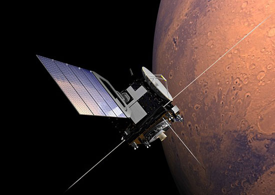
Mars Express

Mars is covered in intriguing scars – some of the most prominent being impact craters. A particularly unusual example is shown in this new image from ESA’s Mars Express: an ancient triplet comprising not one but three overlapping craters.

The crater triplet is located in an especially old part of Mars’ southern hemisphere known as Noachis Terra. This region was heavily cratered during the Noachian era, an ancient time about four billion years ago in Mars’ history in which huge numbers of asteroids and comets flew inwards to crash into the planet's surface. Some of the features created by these collisions remain intact on Mars today and, as they formed during the very earliest days of the Solar System, are of particular interest to scientists seeking to know more about our planetary neighbour and its past.

In context: Triple crater east of Le Verrier

Signs of chaotic Noachian processes and events are seen especially clearly in Mars’ southern highlands, which are peppered with old, time-worn craters. ESA’s Mars Express has imaged many craters in this region, from the severely eroded Greeley Crater, named after the American geologist Ronald Greeley, to the dune-patterned Neukum Crater, named after one of the founders of the Mars Express mission (and the former Principal Investigator of the spacecraft’s High Resolution Stereo Camera (HRSC), the camera responsible for this new image).

This image shows a triple crater found just east of a better-known feature named Le Verrier Crater, which spans nearly 140 km across. By contrast, the three depressions seen here are somewhat smaller; the largest measures 45 km across, and the smallest 28 km.

Perspective view of triple martian crater

How would such a crater triplet form? One possible explanation – and that thought to be most likely – is that the impactor broke into three before hitting the ground, forming a crater trio upon impact. Not all ‘multiple impactors’ leave such clear and neat features in their wake, with many instead showing elongated troughs, non-circular hollows lying closely side-by-side, or only partially overlapping basins. Another explanation could be coincidence: at different points in time, three separate impactors could have hit Mars’ surface in this location, creating a neat superposition of craters completely by chance.

Interestingly, if the impactor did indeed fragment and break apart, this may imply that the atmosphere of Noachian Mars was far denser – and harder to penetrate – than it is now. This points towards an early Mars that was far warmer and wetter than the cold, arid world we see today. Observations from numerous missions are supporting this view and returning evidence that water once flowed across the Red Planet in large amounts, revealing features such as old river valley networks and large lake basins thought to have formed in the Noachian period.

Topographic view of triple crater on Mars

Like many of the ancient and eroded craters in Mars’ southern highlands, these three craters have flattened rims, shallow floors, and have been filled with sediment in the four billion years since their formation. There is also evidence of ice here – the smallest crater has marks that are typically created as ice and debris creep across a surface, similar to how mixed rock-and-ice glaciers or debris-covered ice glaciers move in alpine regions of Earth.

This frame may once have contained other craters, as indicated by the round patches of sunken surface to the top right and bottom left. In fact, despite the cratered nature of Noachis Terra, the environment around this triplet is surprisingly smooth for such ancient terrain. Only a handful of small surrounding craters appear to have clear, sharply defined rims and bowls, indicating that they are relatively young and have not yet begun to erode in earnest. Overall, it seems that older craters in this area have ‘melted down’ into the surface – a phenomenon that is, again, due to ice.

As ice just under the surface of Mars flows and melts over many millions of years, the soil becomes softer. This soft, ice-rich soil subsides more quickly and fills up indentations and depressions more readily, contributing to the smooth appearance of this part of Noachis Terra. This suggests that there must have been a large amount of water present on Mars, at least during the Noachian period, capable of producing a glacier-like flow of abundant ice.

Triple crater east of Le Verrier in 3D

Understanding the history of Mars, and mapping the features covering the planet’s surface in detail, is a key objective of Mars Express. The spacecraft has been exploring the Red Planet since its launch in 2003, and is gearing up to collaborate with a number of new missions that have joined – or will soon join – the spacecraft at Mars. The ESA-Roscosmos ExoMars Trace Gas Orbiter (TGO) arrived in 2016, and the ExoMars Rosalind Franklin rover and its accompanying surface science platform are scheduled for launch in September 2022.

Mars Express spies an ancient triple crater on Mars

Together with Mars Express, these missions will work to fully characterise our neighbour, to help us not only understand more about Mars, but, by comparison, more about the history and nature of our home in the Universe.

Related links:

ExoMars Trace Gas Orbiter (TGO): http://www.esa.int/Science_Exploration/Human_and_Robotic_Exploration/Exploration/ExoMars/First_results_from_the_ExoMars_Trace_Gas_Orbiter

ExoMars Rosalind Franklin rover: http://www.esa.int/Our_Activities/Human_and_Robotic_Exploration/Exploration/ExoMars/ExoMars_2020_rover

Surface science platform: http://m.esa.int/Our_Activities/Human_and_Robotic_Exploration/Exploration/ExoMars/Surface_platform

Mars Express: https://www.esa.int/Science_Exploration/Space_Science/Mars_Express

ESA/DLR/FU Berlin, CC BY-SA 3.0 IGO/NASA MGS MOLA Science Team.

Best regards, Orbiter.ch