jeudi 28 avril 2022

Scientists with NASA’s MMS Mission Crack 60-Year Mystery of Fast Magnetic Explosions


NASA - Magnetospheric Multiscale Mission (MMS) patch.


April 28, 2022

In just minutes, a flare on the Sun can release enough energy to power the whole world for 20,000 years. An explosive process called magnetic reconnection triggers these solar flares and scientists have spent the last half-century trying to understand how the process happens.

Solar flare. Image Credit: NASA

It’s not just a scientific curiosity: A fuller understanding of magnetic reconnection could enable insights into nuclear fusion and provide better predictions of particle storms from the Sun that can affect Earth-orbiting technology.

Now, scientists with NASA’s Magnetospheric Multiscale Mission, or MMS, think they’ve figured it out. The scientists have developed a theory that explains how the most explosive type of magnetic reconnection – called fast reconnection – occurs and why it happens at a consistent speed. The new theory uses a common magnetic effect that’s used in household devices, such as sensors that time vehicle anti-lock braking systems and know when a cell phone flip cover is closed.

“We finally understand what makes this type of magnetic reconnection so fast,” said lead author on the new study Yi-Hsin Liu, a physics professor at Dartmouth College in New Hampshire and the deputy-lead of MMS’ theory and modeling team. “We now have a theory to explain it fully.”

Magnetic reconnection is a process that occurs in plasma, sometimes called the fourth state of matter. Plasma forms when a gas has been energized enough to break apart its atoms, leaving a motley of negatively charged electrons and positively charged ions existing side-by-side. This energetic, fluid-like material is exquisitely sensitive to magnetic fields.

From flares on the Sun, to near-Earth space, to black holes, plasmas throughout the universe undergo magnetic reconnection, which rapidly converts magnetic energy into heat and acceleration. While there are several types of magnetic reconnection, one particularly puzzling variant is known as fast reconnection, which occurs at a predictable rate.
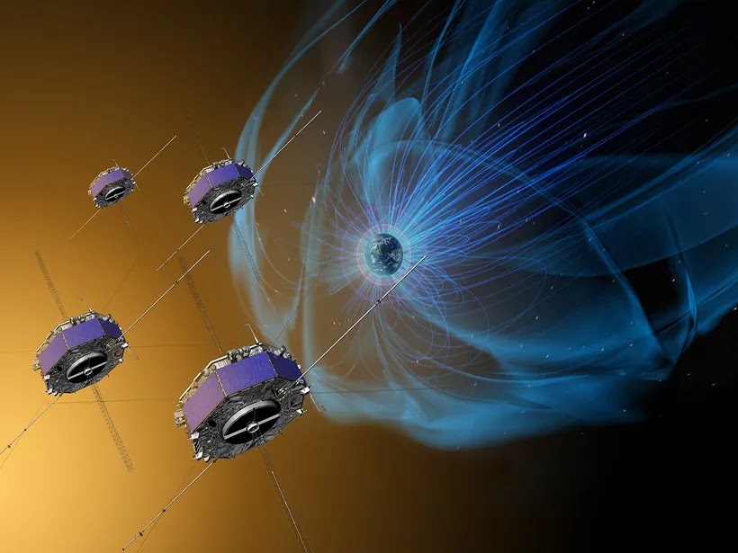
Magnetospheric Multiscale Mission (MMS). Image Credit: NASA

“We have known for a while that fast reconnection happens at a certain rate that seems to be pretty constant,” said Barbara Giles, project scientist for MMS and research scientist at NASA’s Goddard Space Flight Center in Greenbelt, Maryland. “But what really drives that rate has been a mystery, until now.”

The new research, published in a paper in Nature’s Communications Physics journal and funded in part by the National Science Foundation, explains how fast reconnection occurs specifically in collisionless plasmas – a type of plasma whose particles are spread out enough that the individual particles don’t collide with one another. Where reconnection happens in space, most plasma is in this collisionless state, including the plasma in solar flares and the space around Earth.

The new theory shows how and why fast reconnection is likely sped up by the Hall effect, which describes the interaction between magnetic fields and electric currents. The Hall effect is a common magnetic phenomenon that’s used in everyday technology, like vehicle wheel speed sensors and 3D printers, where sensors measure speed, proximity, positioning, or electrical currents.

During fast magnetic reconnection, charged particles in a plasma – namely ions and electrons – stop moving as a group. As the ions and electrons begin moving separately, they give rise to the Hall effect, creating an unstable energy vacuum where reconnection happens. Pressure from the magnetic fields around the energy vacuum causes the vacuum to implode, which quickly releases immense amounts of energy at a predictable rate.


Animation above: This visualization shows the Hall effect, which occurs when the motion of the heavier ions (blue) decouple from the lighter electrons (red) as they enter the region with strong electric currents (golden region). Animation Credits: Tom Bridgman/NASA's Scientific Visualization Studio.

The new theory will be tested in the coming years with MMS, which uses four spacecraft flown around Earth in a pyramid formation to study magnetic reconnection in collisionless plasmas. In this unique space laboratory, MMS can study magnetic reconnection at a higher resolution than would be possible on Earth.

“Ultimately, if we can understand how magnetic reconnection operates, then we can better predict events that can impact us at Earth, like geomagnetic storms and solar flares,” Giles said. “And if we can understand how reconnection is initiated, it will also help energy research because researchers could better control magnetic fields in fusion devices.”

Related Links

NASA Spacecraft Discovers New Magnetic Process in Turbulent Space: https://www.nasa.gov/feature/goddard/2018/nasa-spacecraft-discovers-new-magnetic-process-in-turbulent-space

Learn more about MMS: https://www.nasa.gov/mms

Nature’s Communications Physics: https://www.nature.com/articles/s42005-022-00854-x

The Hall effect: http://svs.gsfc.nasa.gov/4987

Images (mentioned), Animation (mentioned), Text, Credits: NASA/Abbey Interrante/GSFC/By Mara Johnson-Groh.

Greetings, Orbiter.ch

Mars - Tantalising tectonics


ESA - Mars Express Mission patch.


April 28, 2022

This network of long grooves and scratches forms part of a giant fault system on Mars known as Tantalus Fossae, and is shown here as seen by ESA’s Mars Express.

Tantalus Fossae on Mars

At first glance, these features look as if someone has raked their fingernails across the surface of the Red Planet, gouging out lengthy trenches as they did so.

While not quite so dramatic in its formation, Tantalus Fossae (‘fossae’ meaning a hollow or depression) is a noticeable feature on Mars. This system of troughs flanks a sprawling, low-relief martian volcano named Alba Mons, running along the volcano’s eastern side.

Tantalus Fossae in context

The fossae were created as the summit of Alba Mons rose in elevation, causing the surrounding surface to become warped, extended and broken. The Tantalus Fossae faults are a great example of a surface feature known as grabens; each trench formed as two parallel faults opened up, causing the rock between to drop down into the resulting void.

Perspective view of Tantalus Fossae

The same features can be found on the western side of Alba Mons, forming an incomplete ring around the volcano. Overall, this volcano’s associated grabens stretch out for up to 1000 km in length, up to 10 km in width, and are up to 350 m deep.

A complex history

Throughout this Mars Express image, numerous grabens can be seen running roughly northeast (bottom-right) to southwest (top-left).

These structures are thought to have formed not at the same time but one after the other, providing scientists the opportunity to reconstruct a past timeline and picture of what created this dramatic landscape.

The large impact crater at the centre of the image, for example, is crosscut by grabens, indicating that it was already present before the volcano was uplifted to create the Tantalus Fossae faults. The second-largest impact crater (far smaller and to the bottom-left of the central crater) appears to superpose the faults, and is therefore likely to be younger.

Second perspective view of Tantalus Fossae

Upon closer look, many small, branching valleys can be seen across this region. These valleys appear to cut directly through the grabens, and so are assumed to be older.

As shown most clearly in the associated topographic view, the northern (right) part contains far lower terrain than the southern (left) part – in places, as much as three kilometres lower in altitude. We would expect any small, branching valleys to run along the slopes of Alba Mons and merge where the ground is lowest, but this is not seen here, implying that the valleys must originate from more ancient times – before Alba Mons rose to sculpt this terrain into what we see today.

Topography of Tantalus Fossae

This area is named after Tantalus, a son of Zeus and Plouto who, according to Greek legend, betrayed the gods and was forced by Hades to stand in water beneath a fruit tree. When he tried to drink the water retreated, and when he tried to eat the branches moved beyond his reach – a punishment known as the torments of Tantalus.

Exploring Mars

Mars Express has been orbiting the Red Planet since 2003, imaging Mars’ surface, mapping its minerals, identifying the composition and circulation of its tenuous atmosphere, probing beneath its crust, and exploring how various phenomena interact in the martian environment.

Tantalus Fossae in 3D

The mission’s High Resolution Stereo Camera (HRSC), responsible for these new images, has revealed much about Mars’ diverse surface features, with recent images showing everything from wind-sculpted ridges and grooves to volcanoes, impact craters, tectonic faults, river channels and ancient lava pools.

Mars Express

Related link:

Mars Express: https://www.esa.int/Science_Exploration/Space_Science/Mars_Express

Images, Text, Credits: ESA/DLR/FU Berlin, CC BY-SA 3.0 IGO/NASA/MGS/MOLA Science Team.

Best regards, Orbiter.ch

NASA, Partner Decide to Conclude SOFIA Mission


NASA & DLR - Stratospheric Observatory for Infrared Astronomy (SOFIA) patch.

April 28, 2022

NASA and its partners at the German Space Agency at the Deutsches Zentrum für Luft- und Raumfahrt (DLR) will conclude the Stratospheric Observatory for Infrared Astronomy (SOFIA) mission, after a successful eight years of science. SOFIA will end operations no later than Sept. 30, 2022, at the conclusion of its current mission extension.


Image above: The Stratospheric Observatory for Infrared Astronomy (SOFIA). Image Credits: NASA/Jim Ross.

SOFIA is a Boeing 747SP airplane modified to carry a reflecting telescope. SOFIA completed its five-year prime mission in 2019 and currently is completing a three-year mission extension.

As part of its review of the current state of astronomical research, the National Academies’ Decadal Survey on Astronomy and Astrophysics 2020 evaluated SOFIA. The report, which provides peer-reviewed recommendations to NASA for the future of U.S. astrophysics, concluded SOFIA’s science productivity does not justify its operating costs. The report also found SOFIA’s capabilities do not significantly overlap with the science priorities the Decadal Survey has identified for the next decade and beyond.

The Decadal Survey therefore recommended NASA end the SOFIA mission after its current mission extension. NASA and DLR have accepted this recommendation. SOFIA will finish out its scheduled operations for the 2022 fiscal year, followed by an orderly shutdown.

Hundreds of individuals in the United States and Germany have contributed to the SOFIA mission over its lifetime. It began development in 1996, saw first light in 2010, and achieved full operational capability in 2014. In the eight years since, SOFIA’s observations of the Moon, planets, stars, star-forming regions, and nearby galaxies included the discovery of water on the sunlit surface of the Moon in 2020.

Moving forward, SOFIA’s data will be available in NASA’s public archives for astronomers worldwide to use. NASA will continue to advance the future of scientific discovery in infrared astrophysics, starting with the recently launched James Webb Space Telescope, as well as further opportunities recommended by the Decadal Survey.

Stratospheric Observatory for Infrared Astronomy (SOFIA): http://www.nasa.gov/mission_pages/SOFIA/index.html

Image (mentioned), Text, Credits: NASA/Sean Potter.

Greetings, Orbiter.ch
NASA’s Webb In Full Focus, Ready for Instrument Commissioning


NASA / ESA / CSA-ASC - James Webb Space Telescope (JWST) patch.


April 28, 2022

Alignment of NASA’s James Webb Space Telescope is now complete. After full review, the observatory has been confirmed to be capable of capturing crisp, well-focused images with each of its four powerful onboard science instruments. Upon completing the seventh and final stage of telescope alignment, the team held a set of key decision meetings and unanimously agreed that Webb is ready to move forward into its next and final series of preparations, known as science instrument commissioning. This process will take about two months before scientific operations begin in the summer.

Image Credits: NASA/STScI

The alignment of the telescope across all of Webb’s instruments can be seen in a series of images that captures the observatory’s full field of view.

“These remarkable test images from a successfully aligned telescope demonstrate what people across countries and continents can achieve when there is a bold scientific vision to explore the universe,” said Lee Feinberg, Webb optical telescope element manager at NASA’s Goddard Space Flight Center.

James Webb Space Telescope (JWST). Animation Credit: NASA

The optical performance of the telescope continues to be better than the engineering team’s most optimistic predictions. Webb’s mirrors are now directing fully focused light collected from space down into each instrument, and each instrument is successfully capturing images with the light being delivered to them. The image quality delivered to all instruments is “diffraction-limited,” meaning that the fineness of detail that can be seen is as good as physically possible given the size of the telescope. From this point forward the only changes to the mirrors will be very small, periodic adjustments to the primary mirror segments.

“With the completion of telescope alignment and half a lifetime’s worth of effort, my role on the James Webb Space Telescope mission has come to an end,” said Scott Acton, Webb wavefront sensing and controls scientist, Ball Aerospace. “These images have profoundly changed the way I see the universe. We are surrounded by a symphony of creation; there are galaxies everywhere! It is my hope that everyone in the world can see them.”


Image above: Engineering images of sharply focused stars in the field of view of each instrument demonstrate that the telescope is fully aligned and in focus. For this test, Webb pointed at part of the Large Magellanic Cloud, a small satellite galaxy of the Milky Way, providing a dense field of hundreds of thousands of stars across all the observatory’s sensors. The sizes and positions of the images shown here depict the relative arrangement of each of Webb’s instruments in the telescope’s focal plane, each pointing at a slightly offset part of the sky relative to one another. Webb’s three imaging instruments are NIRCam (images shown here at a wavelength of 2 microns), NIRISS (image shown here at 1.5 microns), and MIRI (shown at 7.7 microns, a longer wavelength revealing emission from interstellar clouds as well as starlight). NIRSpec is a spectrograph rather than imager but can take images, such as the 1.1 micron image shown here, for calibrations and target acquisition. The dark regions visible in parts of the NIRSpec data are due to structures of its microshutter array, which has several hundred thousand controllable shutters that can be opened or shut to select which light is sent into the spectrograph. Lastly, Webb’s Fine Guidance Sensor tracks guide stars to point the observatory accurately and precisely; its two sensors are not generally used for scientific imaging but can take calibration images such as those shown here. This image data is used not just to assess image sharpness but also to precisely measure and calibrate subtle image distortions and alignments between sensors as part of Webb’s overall instrument calibration process. Image Credits: NASA/STScI.

Now, the Webb team will turn its attention to science instrument commissioning. Each instrument is a highly sophisticated set of detectors equipped with unique lenses, masks, filters, and customized equipment that helps it perform the science it was designed to achieve. The specialized characteristics of these instruments will be configured and operated in various combinations during the instrument commissioning phase to fully confirm their readiness for science. With the formal conclusion of telescope alignment, key personnel involved with the commissioning of each instrument have arrived at the Mission Operations Center at the Space Telescope Science Institute in Baltimore, and some personnel involved with telescope alignment have concluded their duties.

The Webb Telescope Completes Alignment Phase

Video Credits: NASA’s Goddard Space Flight Center.

Though telescope alignment is complete, some telescope calibration activities remain: As part of scientific instrument commissioning, the telescope will be commanded to point to different areas in the sky where the total amount of solar radiation hitting the observatory will vary to confirm thermal stability when changing targets. Furthermore, ongoing maintenance observations every two days will monitor the mirror alignment and, when needed, apply corrections to keep the mirrors in their aligned locations.

James Webb Space Telescope (JWST): https://www.nasa.gov/mission_pages/webb/main/index.html

Images (mentioned), Video (mentioned), Animation (mentioned), Text, Credits: By Thaddeus Cesari, NASA Goddard.

Greetings, Orbiter.ch

NASA’s Mars Helicopter Spots Gear That Helped Perseverance Rover Land


NASA - Ingenuity Mars Helicopter logo.


April 28, 2022

Eyeing some of the components that enabled the rover to get safely to the Martian surface could provide valuable insights for future missions.


Image above: This image of Perseverance's backshell and supersonic parachute was captured by NASA's Ingenuity Mars Helicopter during its 26th flight on Mars on April 19, 2022. Image Credits: NASA/JPL-Caltech.

NASA’s Ingenuity Mars Helicopter recently surveyed both the parachute that helped the agency’s Perseverance rover land on Mars and the cone-shaped backshell that protected the rover in deep space and during its fiery descent toward the Martian surface on Feb. 18, 2021. Engineers with the Mars Sample Return program asked whether Ingenuity could provide this perspective. What resulted were 10 aerial color images taken April 19 during Ingenuity’s Flight 26.

“NASA extended Ingenuity flight operations to perform pioneering flights such as this,” said Teddy Tzanetos, Ingenuity’s team lead at NASA’s Jet Propulsion Laboratory in Southern California. “Every time we’re airborne, Ingenuity covers new ground and offers a perspective no previous planetary mission could achieve. Mars Sample Return’s reconnaissance request is a perfect example of the utility of aerial platforms on Mars.”


Image above: Rover Landing Gear Seen From the Air by Mars Helicopter. Image Credits: NASA/JPL-Caltech.

Eyeing some of the components that enabled the rover to get safely to the Martian surface could provide valuable insights for future missions.

NASA’s Ingenuity Mars Helicopter recently surveyed both the parachute that

Entry, descent, and landing on Mars is fast-paced and stressful, not only for the engineers back on Earth, but also for the vehicle enduring the gravitational forces, high temperatures, and other extremes that come with entering Mars’ atmosphere at nearly 12,500 mph (20,000 kph). The parachute and backshell were previously imaged from a distance by the Perseverance rover.


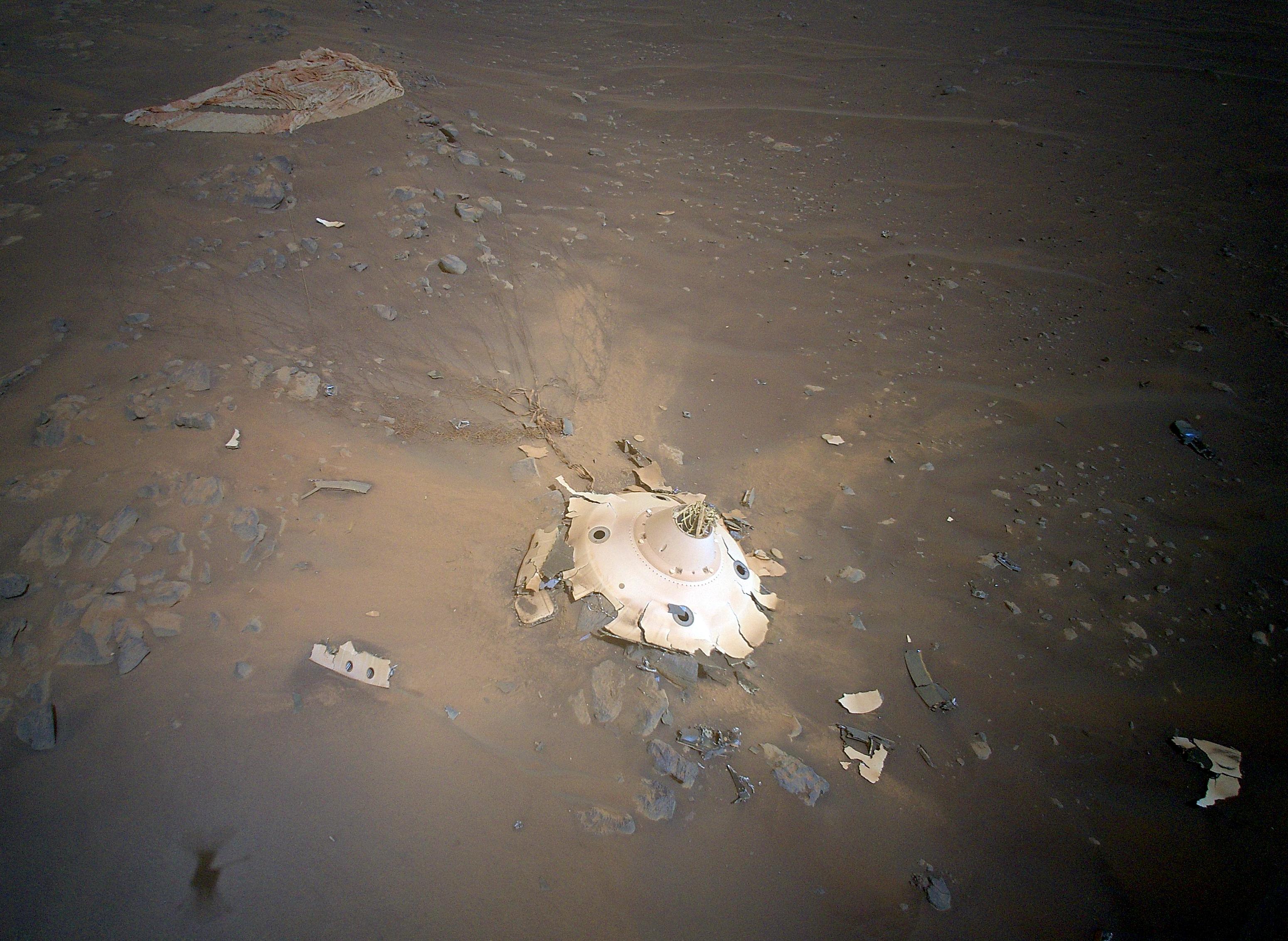
Image above: Perseverance's backshell, supersonic parachute, and associated debris field is seen strewn across the Martian surface in this image captured by NASA's Ingenuity Mars Helicopter during its 26th flight on April 19, 2022. Image Credits: NASA/JPL-Caltech.

But those collected by the rotorcraft (from an aerial perspective and closer) provide more detail. The images have the potential to help ensure safer landings for future spacecraft such as the Mars Sample Return Lander, which is part of a multimission campaign that would bring Perseverance’s samples of Martian rocks, atmosphere, and sediment back to Earth for detailed analysis.

“Perseverance had the best-documented Mars landing in history, with cameras showing everything from parachute inflation to touchdown,” said JPL’s Ian Clark, former Perseverance systems engineer and now Mars Sample Return ascent phase lead. “But Ingenuity’s images offer a different vantage point. If they either reinforce that our systems worked as we think they worked or provide even one dataset of engineering information we can use for Mars Sample Return planning, it will be amazing. And if not, the pictures are still phenomenal and inspiring.”

NASA's Mars 2020 Perseverance Rover Landing Animations

In the images of the upright backshell and the debris field that resulted from it impacting the surface at about 78 mph (126 kph), the backshell’s protective coating appears to have remained intact during Mars atmospheric entry. Many of the 80 high-strength suspension lines connecting the backshell to the parachute are visible and also appear intact. Spread out and covered in dust, only about a third of the orange-and-white parachute – at 70.5 feet (21.5 meters) wide, it was the biggest ever deployed on Mars – can be seen, but the canopy shows no signs of damage from the supersonic airflow during inflation. Several weeks of analysis will be needed for a more final verdict.

Flight 26 Maneuvers

Ingenuity’s 159-second flight began at 11:37 a.m. local Mars time April 19, on the one-year anniversary of its first flight. Flying 26 feet (8 meters) above ground level, Ingenuity traveled 630 feet (192 meters) to the southeast and took its first picture. The rotorcraft next headed southwest and then northwest, taking images at pre-planned locations along the route. Once it collected 10 images in its flash memory, Ingenuity headed west 246 feet (75 meters) and landed. Total distance covered: 1,181 feet (360 meters). With the completion of Flight 26, the rotorcraft has logged over 49 minutes aloft and traveled 3.9 miles (6.2 kilometers).

“To get the shots we needed, Ingenuity did a lot of maneuvering, but we were confident because there was complicated maneuvering on flights 10, 12, and 13,” said Håvard Grip, chief pilot of Ingenuity at JPL. “Our landing spot set us up nicely to image an area of interest for the Perseverance science team on Flight 27, near ‘Séítah’ ridge.”

Perseverance Rover & Ingenuity Mars Helicopter. Animation Credits: NASA/JPL-Caltech

The new area of operations in Jezero Crater’s dry river delta marks a dramatic departure from the modest, relatively flat terrain Ingenuity had been flying over since its first flight. Several miles wide, the fan-shaped delta formed where an ancient river spilled into the lake that once filled Jezero Crater. Rising more than 130 feet (40 meters) above the crater floor and filled with jagged cliffs, angled surfaces, projecting boulders, and sand-filled pockets, the delta promises to hold numerous geologic revelations – perhaps even proof that microscopic life existed on Mars billions of years ago.

Upon reaching the delta, Ingenuity’s first orders may be to help determine which of two dry river channels Perseverance should climb to reach the top of the delta. Along with route-planning assistance, data provided by the helicopter will help the Perseverance team assess potential science targets. Ingenuity may even be called upon to image geologic features too far afield for the rover to reach or to scout landing zones and sites on the surface where sample caches could be deposited for the Mars Sample Return program.

More About Ingenuity

The Ingenuity Mars Helicopter was built by JPL, which also manages the project for NASA Headquarters. It is supported by NASA’s Science Mission Directorate. NASA’s Ames Research Center in California’s Silicon Valley and NASA’s Langley Research Center in Hampton, Virginia, provided significant flight performance analysis and technical assistance during Ingenuity’s development. AeroVironment Inc., Qualcomm, and SolAero also provided design assistance and major vehicle components. Lockheed Space designed and manufactured the Mars Helicopter Delivery System.

At NASA Headquarters, Dave Lavery is the program executive for the Ingenuity Mars Helicopter.

More About Perseverance

A key objective for Perseverance’s mission on Mars is astrobiology, including the search for signs of ancient microbial life. The rover will characterize the planet’s geology and past climate, pave the way for human exploration of the Red Planet, and be the first mission to collect and cache Martian rock and regolith (broken rock and dust).

Subsequent NASA missions, in cooperation with ESA (European Space Agency), would send spacecraft to Mars to collect these sealed samples from the surface and return them to Earth for in-depth analysis.

The Mars 2020 Perseverance mission is part of NASA’s Moon to Mars exploration approach, which includes Artemis missions to the Moon that will help prepare for human exploration of the Red Planet.

JPL, which is managed for NASA by Caltech in Pasadena, California, built and manages operations of the Perseverance rover.

For more information about Ingenuity: https://mars.nasa.gov/technology/helicopter

Related links:

Mars Sample Return Lander: https://www.jpl.nasa.gov/images/pia25277-mars-sample-retrieval-lander-concept-illustration

Mars Sample Return program: https://www.jpl.nasa.gov/missions/mars-sample-return-msr

Mars Helicopter Delivery System: https://mars.nasa.gov/resources/25081/testing-the-mars-helicopter-delivery-system/

Images (mentioned), Animation (mentioned), Video, Text, Credits: NASA/Karen Fox/Alana Johnson/JPL/DC Agle.

Best regards, Orbiter.ch

Spacewalkers Exit Station to Activate New Robotic Arm


ROSCOSMOS - Russian Cosmonaut patch.


April 28, 2022

Expedition 67 Flight Engineers Oleg Artemyev and Denis Matveev of Roscosmos began Russian spacewalk 53 at 10:58 a.m. EDT to continue to activating the new European robotic arm – a 37-foot-long manipulator system mounted to the recently arrived Nauka module.


Image above: Roscosmos cosmonauts (from left) Denis Matveev and Oleg Artemyev are pictured during a spacewalk on April 18, 2022, to configure the European robotic arm. Image Credit: NASA TV.

Coverage of the spacewalk continues on NASA Television, the NASA app, and the agency’s website: https://www.nasa.gov/nasalive

During the spacewalk, the duo will monitor the first commanded movements of the robotic arm from its grapple fixtures after removing thermal blankets and launch locks. The arm’s end effectors will translate one at a time to a new base points. The crew also will install more handrails on Nauka.


Image above: Roscosmos cosmonaut Oleg Artemyev waves to the camera during a spacewalk on April 18, 2022, to configure the European robotic arm. Image Credit: NASA TV.

Artemyev is wearing a Russian Orlan spacesuit with red stripes. Matveev will wear a spacesuit with blue stripes. This is the fifth spacewalk in Artemyev’s career, and the second for Matveev. It is the fifth spacewalk at the station in 2022 and the 250th spacewalk for space station assembly, maintenance, and upgrades.

Related link:

Nauka multipurpose laboratory module: https://www.roscosmos.ru/tag/nauka/

International Space Station (ISS): https://www.nasa.gov/mission_pages/station/main/index.html

Images (mentioned), Text, Credits: NASA/Mark Garcia.

Greetings, Orbiter.ch

Crew-4 Now Aboard the Space Station


ISS - Expedition 67 Mission patch.


April 27, 2022

NASA astronauts Mission Commander Kjell Lindgren, Pilot Bob Hines, and Mission Specialist Jessica Watkins, and Mission Specialist Samantha Cristoforetti of ESA (European Space Agency) now are aboard the International Space Station following Crew Dragon’s hatch opening about 9:15 p.m. EDT, Wednesday, April 27.


Image above: Crew-4 NASA astronauts Mission Commander Kjell Lindgren, Pilot Bob Hines, and Mission Specialist Jessica Watkins, and Mission Specialist Samantha Cristoforetti of ESA (European Space Agency) were greeted by Crew-3 as they arrived to the International Space Station. Image Credit: NASA TV.

Crew-4 joins Expedition 67 crew of Raja Chari, Thomas Marshburn, and Kayla Barron, all of NASA, Matthias Maurer of ESA, and cosmonauts Oleg Artemyev, Sergey Korsakov, and Denis Matveev of Roscosmos.

NASA TV coverage will conclude shortly after hatch opening and return for live coverage of the welcoming ceremony at 2:40 a.m. Thursday, April 28.

Samantha Cristoforetti and the rest of Crew-4 arrives at the International Space Station

Crew-4 astronauts launched to International Space Station at 3:52 a.m. Wednesday, April 27, from Launch Complex 39A at NASA’s Kennedy Space Center in Florida. The international crew of four will spend several months on the orbital complex on a science expedition mission.

Related articles:

The Crew-4 Astronauts Dock to the Space Station
https://orbiterchspacenews.blogspot.com/2022/04/the-crew-4-astronauts-dock-to-space.html

Crew-4: NASA TV Coverage Continues, Dragon Ahead of Schedule for Docking
https://orbiterchspacenews.blogspot.com/2022/04/crew-4-nasa-tv-coverage-continues.html

NASA’s SpaceX Crew-4 Astronauts Launch to International Space Station
https://orbiterchspacenews.blogspot.com/2022/04/nasas-spacex-crew-4-astronauts-launch.html

Crew-4 Astronauts Head to Space Station to Conduct Microgravity Science
https://orbiterchspacenews.blogspot.com/2022/04/crew-4-astronauts-head-to-space-station.html

Related links:

NASA TV: https://www.nasa.gov/live

Expedition 67: https://www.nasa.gov/mission_pages/station/expeditions/expedition67/index.html

International Space Station (ISS): https://www.nasa.gov/mission_pages/station/main/index.html

Image (mentioned), Video, Text, Credits: NASA/Heidi Lavelle/NASA TV/ESA.

Best regards, Orbiter.ch