vendredi 16 décembre 2022

Hubble Views a Star-Studded Cosmic Cloud


NASA / ESA - Hubble Space Telescope (HST) patch.


Dec 16, 2022

A portion of the open cluster NGC 6530 appears as a roiling wall of smoke studded with stars in this image from the NASA/ESA Hubble Space Telescope. NGC 6530 is a collection of several thousand stars lying around 4,350 light-years from Earth in the constellation Sagittarius. The cluster is set within the larger Lagoon Nebula, a gigantic interstellar cloud of gas and dust. Hubble has previously imaged the Lagoon Nebula several times, including these images released in 2010 and 2011. It is the nebula that gives this image its distinctly smoky appearance; clouds of interstellar gas and dust stretch from one side of the image to the other.

Astronomers investigated NGC 6530 using Hubble’s Advanced Camera for Surveys and Wide Field Planetary Camera 2. They scoured the region in the hope of finding new examples of proplyds, a particular class of illuminated protoplanetary discs surrounding newborn stars. The vast majority of known proplyds are found in only one region, the nearby Orion Nebula. This makes understanding their origin and lifetimes in other astronomical environments challenging.

Hubble’s ability to observe at near-infrared wavelengths – particularly with Wide Field Camera 3 – have made it an indispensable tool for understanding star birth and the origin of exoplanetary systems. The new NASA/ESA/CSA James Webb Space Telescope’s unprecedented observational capabilities at infrared wavelengths will complement Hubble observations by allowing astronomers to peer through the dusty envelopes around newly born stars and investigate the faintest, earliest stages of star birth.

Hubble Space Telescope (HST)

For more information about Hubble, visit:

http://hubblesite.org/

http://www.nasa.gov/hubble

https://esahubble.org/

Related links:

Advanced Camera for Surveys: https://www.nasa.gov/content/hubble-space-telescope-advanced-camera-for-surveys

Wide Field Planetary Camera 2: https://www.jpl.nasa.gov/missions/wide-field-and-planetary-camera-2-wfpc2

Wide Field Camera 3: https://www.nasa.gov/content/hubble-space-telescope-wide-field-camera-3

Text Credits: European Space Agency (ESA)/NASA/Andrea Gianopoulos/Image, Animation Credits: ESA/Hubble & NASA, O. De Marco; Acknowledgment: M.H. Özsaraç.

Greetings, Orbiter.ch

NASA Developing AI to Steer Using Landmarks – On the Moon


NASA - Lunar Reconnaissance Orbiter (LRO) patch.


Dec 16, 2022

Much like how familiar landmarks can give travelers a sense of direction when their smart phones lose their lock on GPS signals, a NASA engineer is teaching a machine to use features on the Moon’s horizon to navigate across the lunar surface.

“For safety and science geotagging, it’s important for explorers to know exactly where they are as they explore the lunar landscape,” said Alvin Yew, a research engineer at NASA’s Goddard Space Flight Center in Greenbelt, Maryland. “Equipping an onboard device with a local map would support any mission, whether robotic or human.”

Image above: The collection of ridges, craters, and boulders that form a lunar horizon can be used by an artificial intelligence to accurately locate a lunar traveler. A system being developed by Research Engineer Alvin Yew would provide a backup location service for future explorers, robotic or human. Image Credits: NASA/MoonTrek/Alvin Yew.

NASA is currently working with industry and other international agencies to develop a communications and navigation architecture for the Moon. LunaNet will bring “internet-like” capabilities to the Moon, including location services.

However, explorers in some regions on the lunar surface may require overlapping solutions derived from multiple sources to assure safety should communication signals not be available.

“It’s critical to have dependable backup systems when we’re talking about human exploration,” Yew said. “The motivation for me was to enable lunar crater exploration, where the entire horizon would be the crater rim.”

Yew started with data from NASA’s Lunar Reconnaissance Orbiter, specifically the Lunar Orbiter Laser Altimeter (LOLA). LOLA measures slopes, lunar surface roughness, and generates high resolution topographic maps of the Moon. Yew is training an artificial intelligence to recreate features on the lunar horizon as they would appear to an explorer on the lunar surface using LOLA’s digital elevation models. Those digital panoramas can be used to correlate known boulders and ridges with those visible in pictures taken by a rover or astronaut, providing accurate location identification for any given region.

Lunar Reconnaissance Orbiter (LRO). Animation Credit: NASA

“Conceptually, it’s like going outside and trying to figure out where you are by surveying the horizon and surrounding landmarks,” Yew said. “While a ballpark location estimate might be easy for a person, we want to demonstrate accuracy on the ground down to less than 30 feet (9 meters). This accuracy opens the door to a broad range of mission concepts for future exploration.”

Making efficient use of LOLA data, a handheld device could be programmed with a local subset of terrain and elevation data to conserve memory. According to work published by Goddard researcher Erwan Mazarico, a lunar explorer can see at most up to about 180 miles (300 kilometers) from any unobstructed location on the Moon. Even on Earth, Yew’s location technology could help explorers in terrain where GPS signals are obstructed or subject to interference.

Yew’s geolocation system will leverage the capabilities of GIANT (Goddard Image Analysis and Navigation Tool). This optical navigation tool developed primarily by Goddard engineer Andrew Liounis previously double-checked and verified navigation data for NASA’s OSIRIS-REx mission to collect a sample from asteroid Bennu (see CuttingEdge, Summer 2021).

In contrast to radar or laser-ranging tools that pulse radio signals and light at a target to analyze the returning signals, GIANT quickly and accurately analyzes images to measure the distance to and between visible landmarks. The portable version is cGIANT, a derivative library to Goddard’s autonomous Navigation Guidance and Control system (autoGNC) which provides mission autonomy solutions for all stages of spacecraft and rover operations.

Combining AI interpretations of visual panoramas against a known model of a moon or planet’s terrain could provide a powerful navigation tool for future explorers.

Related links:

Lunar Reconnaissance Orbiter (LRO): https://www.nasa.gov/mission_pages/LRO/main/index.html

CuttingEdge, Summer 2021: https://issuu.com/nasagsfc/docs/summer_2021_final_high/s/12940051

Image (mentioned), Animation (mentioned), Text, Credits: NASA/GSFC/By Karl B. Hille.

Greetings, Orbiter.ch

Space Station Science Highlights: Week of December 12, 2022


ISS - Expedition 68 mission patch.


Dec 16, 2022

Crew members aboard the International Space Station conducted scientific investigations during the week of Dec 12 that included analyzing the psychological benefits of growing plants in space, testing a new space crop, and observing liquid behavior in microgravity.

International Space Station (ISS). Animation Credit: ESA

Here are details on some of the microgravity investigations currently taking place aboard the orbiting lab:

Space gardening

The Pick-and-Eat Salad-Crop Productivity, Nutritional Value, and Acceptability to Supplement the ISS Food System phased research project examines growing plants to provide fresh food and enhance the overall living experience for crew members on future long-duration missions. It includes two NASA Human Research Program investigations conducted this week.

Image above: The Veggie plant growth habitat on the International Space Station supports a variety of investigations, including HRF Veg, which examines the behavioral health benefits for crew members of having live plants and fresh food in space. Image Credit: NASA.

HRF Veg examines the behavioral health benefits of having live plants and fresh food in space. Crew members complete surveys to evaluate their moods and assess psychological benefits from interacting with the plants grown on the space station. When produce is available from other plant investigations, they rate its flavor, texture, and other qualities. During the week, crew members completed questionnaires.

Animation above: NASA astronaut Josh Cassada works on the Veg-05 investigation, which grows dwarf tomatoes and examines the effect of light quality and fertilizer on fruit production, microbial food safety, nutritional value, taste acceptability by the crew, and overall behavioral health benefits of live plants on the space station. Animation Credit: NASA.

Veg-05 uses the station’s Veggie facility to grow dwarf tomatoes and examine the effects of light quality and fertilizer on fruit production, microbial safety, nutritional value, taste acceptability, and overall behavioral health benefits. The hardware, similar to a miniature greenhouse, could be adapted for horticultural therapy for elderly or disabled individuals and to provide fresh produce for those without access to a yard on Earth. Crew members installed plant pillows in the Veggie facility, set light time intervals, and took photos during the week.

Looking at liquids

Animation above: JAXA astronaut Koichi Wakata conducts operations for Liquid Behavior, a JAXA investigation that observes liquid behavior inside a container. Results could support improved design of equipment for future space missions. Animation Credit: NASA.

Fluid behaves differently in microgravity than on Earth, which can affect the performance of fluid-based systems. The Liquid Behavior investigation from the Japan Aerospace Exploration Agency (JAXA) observes liquid behavior inside a container. Better prediction of how fluids behave could support optimal design of equipment for future space missions, including lunar rovers, life support systems, and fuel tanks. During the week, crew members installed the investigation, conducted runs, and closed out operations.

Other investigations involving the crew:

- The Plant Habitat-03 investigation assesses whether epigenetic adaptations in one generation of plants grown in space can transfer to the next generation. Results could provide insight into how to grow repeated generations of crops to provide food and other services on future space missions.
https://www.nasa.gov/mission_pages/station/research/experiments/explorer/Investigation.html?#id=8336

- STaARS BioScience–15, sponsored by the ISS National Lab, evaluates a treatment for eliminating biofilms that is safe for crew members and equipment. A better understanding of these microbial communities in space could improve biofilm control on future missions, including Artemis and voyages to Mars.
https://www.nasa.gov/mission_pages/station/research/experiments/explorer/Investigation.html?#id=8832

- RFID Smart Sensing extends the reach of radio frequency identification (RFID) signals to behind stowage racks and places motion sensors on rack doors. Results could increase the accuracy of inventory and item location and free up more crew time for scientific investigations and other activities.
https://www.nasa.gov/mission_pages/station/research/experiments/explorer/Investigation.html?#id=8319

- JAXA Low Temp Protein Crystallization Growth (PCG) grows high-quality protein crystals to determine protein structures in detail. Results could contribute to expanded use of the orbiting lab to produce crystals for development of pharmaceuticals and other biological products.
https://www.nasa.gov/mission_pages/station/research/experiments/explorer/Investigation.html?#id=2031

Space to Ground: What's Past is Prologue: 12/16/2022

The space station, a robust microgravity laboratory with a multitude of specialized research facilities and tools, has supported many scientific breakthroughs from investigations spanning every major scientific discipline. The ISS Benefits for Humanity 2022 publication details the expanding universe of results realized from more than 20 years of experiments conducted on the station.

Related links:

Expedition 68: https://www.nasa.gov/mission_pages/station/expeditions/expedition68/index.html

HRF Veg: https://www.nasa.gov/mission_pages/station/research/experiments/explorer/Investigation.html?#id=8434

Veg-05: https://www.nasa.gov/mission_pages/station/research/experiments/explorer/Investigation.html?#id=7443

Veggie: https://www.nasa.gov/mission_pages/station/research/experiments/explorer/Facility.html?#id=374

Liquid Behavior: https://www.nasa.gov/mission_pages/station/research/experiments/explorer/Investigation.html?#id=8736

ISS National Lab: https://www.issnationallab.org/

Spot the Station: https://spotthestation.nasa.gov/

Space Station Research and Technology: https://www.nasa.gov/mission_pages/station/research/overview.html

International Space Station (ISS): https://www.nasa.gov/mission_pages/station/main/index.html

Animations (mentioned), Image (mentioned), Video (NASA), Text, Credits: NASA/Ana Guzman/John Love, ISS Research Planning Integration Scientist Expedition 68.

Best regards, Orbiter.ch

NASA’s Perseverance Rover to Begin Building Martian Sample Depot


NASA - Mars 2020 Perseverance Rover logo.


Dec 16, 2022

The 10 sample tubes being dropped on Mars’ surface so they can be studied on Earth in the future carry an amazing diversity of Red Planet geology.

Image above: The location where NASA’s Perseverance will begin depositing its first cache of samples is shown in this image taken by the Mars rover on Dec. 14, 2022, the 646th Martian day, or sol, of the mission. Image Credits: NASA/JPL-Caltech/ASU/MSSS.

In the coming days, NASA’s Perseverance rover is expected to begin building the first sample depot on another world. This will mark a crucial milestone in the NASA-ESA (European Space Agency) Mars Sample Return campaign, which aims to bring Mars samples to Earth for closer study.

The depot-building process starts when the rover drops one of its titanium sample tubes carrying a chalk-size core of rock from its belly 2.9 feet (88.8 centimeters) onto the ground at an area within Jezero Crater nicknamed “Three Forks.” Over the course of 30 or so days, Perseverance will deposit a total of 10 tubes that carry samples representing the diversity of the rock record in Jezero Crater.

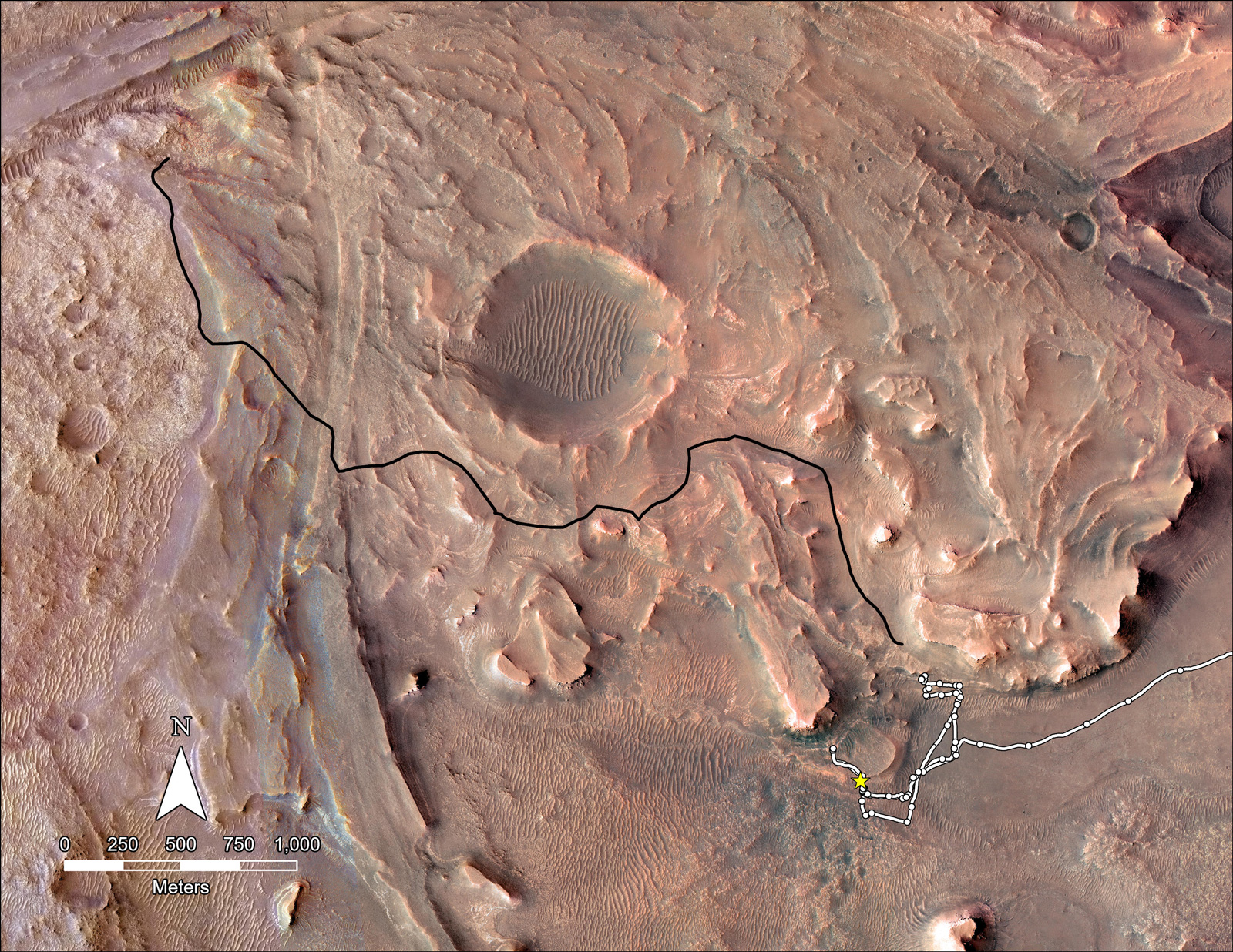
Image above: This map shows the planned route NASA’s Perseverance Mars rover will take across the top of Jezero Crater’s delta in 2023. The rover’s planned route is in black while the ground it already covered is in white. Image Credits: NASA/JPL-Caltech.

The rover has been taking a pair of samples from each of its rock targets. Half of every pair will be deposited at Three Forks as a backup set, and the other half will remain inside Perseverance, which will be the primary means to convey the collected samples to the Mars launch vehicle as part of the campaign.

“The samples for this depot – and the duplicates held aboard Perseverance – are an incredible set representative of the area explored during the prime mission,” said Meenakshi Wadhwa, the Mars Sample Return program principal scientist from Arizona State University. “We not only have igneous and sedimentary rocks that record at least two and possibly four or even more distinct styles of aqueous alteration, but also regolith, atmosphere, and a witness tube.”

Image above: Shown here is a representation of the 21 sample tubes (containing rock, regolith, atmosphere, and witness materials) that have been sealed to date by NASA’s Perseverance Mars rover. The samples Perseverance is depositing into a depot are highlighted in green. Image Credits: NASA/JPL-Caltech.

How to Build a Depot

One of the first requirements to build a sample depot on Mars is to find a level, rock-free stretch of terrain in Jezero Crater where there’s room for each tube to be deposited.

“Up to now, Mars missions required just one good landing zone; we need 11,” said Richard Cook, Mars Sample Return program manager at NASA’s Jet Propulsion Laboratory in Southern California. “The first one is for the Sample Retrieval Lander, but then we need 10 more in the vicinity for our Sample Recovery Helicopters to perform takeoffs and landings, and driving too.”

Image above: NASA’s Perseverance Mars rover used its Mastcam-Z camera to capture this rocky hilltop nicknamed “Rockytop” on July 24, 2022, the 507th Martian day, or sol, of the mission. Image Credits: NASA/JPL-Caltech/ASU/MSSS.

After settling on a suitable site, the campaign’s next task was to figure out exactly where and how to deploy the tubes within that location. “You can’t simply drop them in a big pile because the recovery helicopters are designed to interact with only one tube at a time,” said Cook. The helicopters are intended to serve as a backup, just like the depot. To ensure a helicopter could retrieve samples without disturbing the rest of the depot or encountering any obstructions from the occasional rock or ripple, each tube-drop location will have an “area of operation” at least 18 feet (5.5 meters) in diameter. To that end, the tubes will be deposited on the surface in an intricate zigzag pattern, with each sample 16 to 49 feet (5 to 15 meters) apart from one another.

The depot’s success will depend on accurate placement of the tubes – a process that will take over a month. Before and after Perseverance drops each tube, mission controllers will review a multitude of images from the rover. This assessment will also give the Mars Sample Return team the precise data necessary to locate the tubes in the event of the samples becoming covered by dust or sand before they are collected.

Image above: This map shows where NASA’s Perseverance Mars rover will be dropping 10 samples that a future mission could pick up. The orange circles represent areas where a Sample Recovery Helicopter could safely operate to acquire the sample tubes. Image Credits: NASA/JPL-Caltech.

Perseverance’s Extended Mission


Perseverance’s prime mission will conclude on Jan. 6, 2023 – one Mars year (about 687 Earth days) after its Feb. 18, 2021, landing.

“We will still be working the sample depot deployment when our extended mission begins on Jan. 7, so nothing changes from that perspective,” said Art Thompson, Perseverance’s project manager at JPL. “However, once the table is set at Three Forks, we’ll head to the top of the delta. The science team wants to take a good look around up there.”

Called the Delta Top Campaign, this new science phase will begin when Perseverance finishes its ascent of the delta’s steep embankment and arrives at the expanse that forms the upper surface of the Jezero delta, probably sometime in February. During this approximately eight-month campaign, the science team will be on the lookout for boulders and other materials that were carried from elsewhere on Mars and deposited by the ancient river that formed this delta.

Mars Sample Return: Bringing Mars Rock Samples Back to Earth

Video above: This short animation features key moments of NASA and ESA’s Mars Sample Return campaign, from landing on Mars and securing the sample tubes to launching them off the surface and ferrying them back to Earth. Video Credits: NASA/ESA/JPL-Caltech/GSFC/MSFC.

“The Delta Top Campaign is our opportunity to get a glimpse at the geological process beyond the walls of Jezero Crater,” said JPL’s Katie Stack Morgan, deputy project scientist for Perseverance. “Billions of years ago a raging river carried debris and boulders from miles beyond the walls of Jezero. We are going to explore these ancient river deposits and obtain samples from their long-traveled boulders and rocks.”

More About the Mission

A key objective for Perseverance’s mission on Mars is astrobiology, including caching samples that may contain signs of ancient microbial life. The rover will characterize the planet’s geology and past climate, pave the way for human exploration of the Red Planet, and be the first mission to collect and cache Martian rock and regolith.

Subsequent NASA missions, in cooperation with ESA, would send spacecraft to Mars to collect these sealed samples from the surface and return them to Earth for in-depth analysis.

The Mars 2020 Perseverance mission is part of NASA’s Moon to Mars exploration approach, which includes Artemis missions to the Moon that will help prepare for human exploration of the Red Planet.

JPL, which is managed for NASA by Caltech, built and manages operations of the Perseverance rover.

For more about Perseverance:

https://mars.nasa.gov/mars2020/ and http://www.nasa.gov/perseverance

More About the Campaign

The NASA-ESA Mars Sample Return Campaign will revolutionize humanity’s understanding of Mars by bringing scientifically selected samples to Earth for study using the most sophisticated instruments around the world. The campaign would fulfill a solar system exploration goal, a high priority since the 1970s and in the last three National Academy of Sciences Planetary Decadal Surveys.

This strategic NASA and ESA partnership would be the first mission to return samples from another planet and the first launch from the surface of another planet. The samples collected by Perseverance during its exploration of an ancient river delta are thought to present the best opportunity to reveal the early evolution of Mars, including the potential for life. By better understanding the history of Mars, we would improve our understanding of all rocky planets in the solar system, including Earth.

Learn more about the Mars Sample Return Program here: https://mars.nasa.gov/msr/

Images (mentioned), Video (mentioned), Text, Credits: NASA/Naomi Hartono/Karen Fox/Alana Johnson/JPL/DC Agle.

Greetings, Orbiter.ch

NASA Launches International Mission to Survey Earth’s Water


SpaceX - Falcon 9 / SWOT Mission patch.


Dec 16, 2022

A satellite built for NASA and the French space agency Centre National d’Études Spatiales (CNES) to observe nearly all the water on our planet’s surface lifted off on its way to low-Earth orbit at 3:46 a.m. PST on Friday. The Surface Water and Ocean Topography (SWOT) spacecraft also has contributions from the Canadian Space Agency (CSA) and the UK Space Agency.

Image above: A SpaceX Falcon 9 rocket launches with the Surface Water and Ocean Topography (SWOT) spacecraft onboard, Friday, Dec. 16, 2022, from Space Launch Complex 4E at Vandenberg Space Force Base in California. Jointly developed by NASA and Centre National D'Etudes Spatiales (CNES), with contributions from the Canadian Space Agency (CSA) and United Kingdom Space Agency, SWOT is the first satellite mission that will observe nearly all water on Earth’s surface, measuring the height of water in the planet’s lakes, rivers, reservoirs, and the ocean. Image Credits: NASA/Keegan Barber.

The SWOT spacecraft launched atop a SpaceX rocket from Space Launch Complex 4E at Vandenberg Space Force Base in California with a prime mission of three years. The satellite will measure the height of water in freshwater bodies and the ocean on more than 90% of Earth’s surface. This information will provide insights into how the ocean influences climate change; how a warming world affects lakes, rivers, and reservoirs; and how communities can better prepare for disasters, such as floods.

SWOT launch and Falcon 9 first stage landing

After SWOT separated from the second stage of a SpaceX Falcon 9 rocket, ground controllers successfully acquired the satellite’s signal. Initial telemetry reports showed the spacecraft in good health. SWOT will now undergo a series of checks and calibrations before it starts collecting science data in about six months.

“Warming seas, extreme weather, more severe wildfires – these are only some of the consequences humanity is facing due to climate change,” said NASA Administrator Bill Nelson. “The climate crisis requires an all-hands-on-deck approach, and SWOT is the realization of a long-standing international partnership that will ultimately better equip communities so that they can face these challenges.”

SWOT deployment

SWOT will cover the entire Earth’s surface between 78 degrees south and 78 degrees north latitude at least once every 21 days, sending back about one terabyte of unprocessed data per day. The scientific heart of the spacecraft is an innovative instrument called the Ka-band radar interferometer (KaRIn), which marks a major technological advance. KaRIn bounces radar pulses off the water’s surface and receives the return signal using two antennas on either side of the spacecraft. This arrangement – one signal, two antennas – will enable engineers to precisely determine the height of the water’s surface across two swaths at a time, each of them 30 miles (50 kilometers) wide.

“We’re eager to see SWOT in action,” said Karen St. Germain, NASA Earth Science Division director. “This satellite embodies how we are improving life on Earth through science and technological innovations. The data that innovation will provide is essential to better understanding how Earth’s air, water, and ecosystems interact – and how people can thrive on our changing planet.”

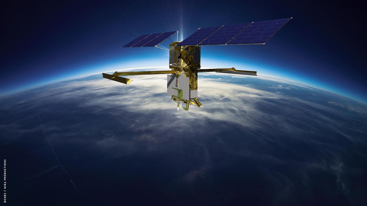
Surface Water and Ocean Topography (SWOT) spacecraft. Image Credits: CNES/MIRA

Among the many benefits the SWOT mission will provide is a significantly clearer picture of Earth’s freshwater bodies. It will provide data on more than 95% of the world’s lakes larger than 15 acres (62,500 square meters) and rivers wider than 330 feet (100 meters) across. Currently, freshwater researchers have reliable measurements for only a few thousand lakes around the world. SWOT will push that number into the millions.

Along the coast, SWOT will provide information on sea level, filling in observational gaps in areas that don’t have tide gauges or other instruments that measure sea surface height. Over time, that data can help researchers better track sea level rise, which will directly impact communities and coastal ecosystems.

Such an ambitious mission is possible because of NASA’s long-standing commitment to working with agencies around the world to study Earth and its climate. NASA and CNES have built upon a decades-long relationship that started in the 1980s to monitor Earth’s oceans. This collaboration pioneered the use of a space-based instrument called an altimeter to study sea level with the launch of the TOPEX/Poseidon satellite in 1992.

“This mission marks the continuity of 30 years of collaboration between NASA and CNES in altimetry,” said Caroline Laurent, CNES Orbital Systems and Applications director. “It shows how international collaboration can be achieved through a breakthrough mission that will help us better understand climate change and its effects around the world.”

SWOT measurements will also help researchers, policymakers, and resource managers better assess and plan for things, including floods and droughts. By providing information on where the water is – where it’s coming from and where it’s going – researchers can improve flood projections for rivers and monitor drought effects on lakes and reservoirs.

“SWOT will provide vital information, given the urgent challenges posed by climate change and sea level rise,” said Laurie Leshin, NASA’s Jet Propulsion Laboratory (JPL) director. JPL developed the KaRIn instrument and manages the U.S. portion of the mission. “That SWOT will fill gaps in our knowledge and inform future action is the direct result of commitment, innovation, and collaboration going back many years. We’re excited to get SWOT science underway.”

More Mission Information

JPL, which is managed for NASA by Caltech in Pasadena, California, leads the U.S. component of the project. For the flight system payload, NASA is providing the KaRIn instrument, a GPS science receiver, a laser retroreflector, a two-beam microwave radiometer, and NASA instrument operations. CNES is providing the Doppler Orbitography and Radioposition Integrated by Satellite (DORIS) system, the dual frequency Poseidon altimeter (developed by Thales Alenia Space), the KaRIn radio-frequency subsystem (together with Thales Alenia Space and with support from the UK Space Agency), the satellite platform, and ground control segment. CSA is providing the KaRIn high-power transmitter assembly. NASA is providing the launch vehicle and the agency’s Launch Services Program, based at Kennedy Space Center, is managing the associated launch services.

To learn more about SWOT, visit: https://www.nasa.gov/swot

Related link:

SpaceX: https://www.spacex.com/

Images (mentioned), Videos, Text, Credits: NASA/Tylar Greene/KSC/Leejay Lockhart/Laura Aguiar/JPL/Jane J. Lee/Andrew Wang/NASA TV/SciNews.

Best regards, Orbiter.ch

CASC - Long March-11 launches Shiyan-21


CASC - China Aerospace Science and Technology Corporation logo.


Dec 16, 2022

Long March-11 carrying Shiyan-21 liftoff

A Long March-11 launch vehicle launched the Shiyan-21 satellite (试验二十一号卫星) from the Xichang Satellite Launch Center, Sichuan Province, China, on 16 December 2022, at 06:17 UTC (14:17 local time).

Long March-11 launches Shiyan-21

According to official sources, the satellite was placed in the planned orbit and “will be used for in-orbit verification of new space technologies”.

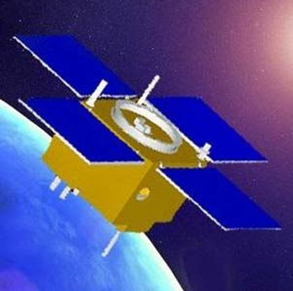
Shiyan-21 satellite

For more information about China Aerospace Science and Technology Corporation (CASC), visit: http://english.spacechina.com/n16421/index.html
 
Images, Video, Text, Credits: China Media Group(CMG)/China Central Television (CCTV)/China Aerospace Science and Technology Corporation (CASC)/SciNews/Orbiter.ch Aerospace/Roland Berga.

Greetings, Orbiter.ch

jeudi 15 décembre 2022

NASA Provides Update on International Space Station Operations


ISS - Expedition 68 Mission patch.


Dec 15, 2022

On Wednesday, Dec. 14, an external leak was detected from the Roscosmos Soyuz MS-22 spacecraft docked to the Rassvet module on the International Space Station. The external radiator cooling loop of the Soyuz is the suspected leak source.

The Roscosmos Mission Control team in Moscow postponed Wednesday evening’s planned spacewalk with two cosmonauts to evaluate the situation and data from the Soyuz spacecraft. None of the crew members aboard the space station was in danger, and all conducted normal operations throughout the day.

Image above: The Soyuz MS-22 crew ship is pictured docked to the Rassvet module. In the background, the Prichal docking module is attached to the Nauka multipurpose laboratory module. Image Credit: NASA.

Roscosmos is closely monitoring Soyuz spacecraft temperatures, which remain within acceptable limits. NASA and Roscosmos continue to coordinate external imagery and inspection plans to aid in evaluating the external leak location. Plans for an additional inspection of the Soyuz exterior using the station’s Canadarm2 robotic arm are underway.

The leak was first detected around 7:45 p.m. EST Dec. 14 when data from multiple pressure sensors in the cooling loop showed low readings. At that time, cosmonauts Sergey Prokopyev and Dmitri Petelin were preparing to conduct a spacewalk. The cosmonauts did not exit the space station, and no crew members were exposed to the leaking coolant.

International Space Station (ISS). Animation Credit: ESA

The Soyuz MS-22 spacecraft carried NASA astronaut Frank Rubio and Roscosmos cosmonauts Sergey Prokopyev and Dmitri Petelin into space after launching from the Baikonur Cosmodrome in Kazakhstan on Sept. 21.

The crew aboard station completed normal operations Thursday, including participating in science investigations and research, as well as configuring tools ahead of a planned U.S. spacewalk on Monday, Dec. 19. Specialists are working through robotic plans ahead of Monday’s spacewalk to best optimize for upcoming station operations and the Soyuz inspection.

A Roscosmos spacewalk scheduled for Dec. 21 is indefinitely postponed as the team continues its investigation of the Soyuz spacecraft.

More updates will be provided as data becomes available.

Related article:

Spacewalk Cancelled, Mission Controllers Evaluate Leak on Soyuz
https://orbiterchspacenews.blogspot.com/2022/12/spacewalk-cancelled-mission-controllers.html

Related links:

Expedition 68: https://www.nasa.gov/mission_pages/station/expeditions/expedition68/index.html

Rassvet module: https://www.nasa.gov/mission_pages/station/structure/elements/rassvet

Canadarm2 robotic arm: https://www.nasa.gov/mission_pages/station/structure/elements/mobile-servicing-system.html

International Space Station (ISS): https://www.nasa.gov/mission_pages/station/main/index.html

Image (mentioned), Animation (mentioned), Text, Credits: NASA/Mark Garcia.

Greetings, Orbiter.ch