lundi 5 octobre 2015

NASA Orbiter Views Sites of Fiction Film's Mars Landings


NASA - Mars Reconnaissance Orbiter (MRO) logo.

Oct. 5, 2015

Images from a NASA Mars orbiter's telescopic camera reveal details of real regions on Mars where a new Hollywood movie, "The Martian," places future astronaut adventures.


Image above: This May 2015 image from the HiRISE camera on NASA's Mars Reconnaissance Orbiter shows a location on Mars associated with the best-selling novel and Hollywood movie, "The Martian." It is in a region called Acidalia Planitia, at the landing site for the science-fiction tale's Ares 3 mission. Image Credits: NASA/JPL-Caltech/Univ. of Arizona.

The novel of the same name used actual locations on Mars for the landing sites for its "Ares 3" and "Ares 4" missions. The landing sites for "Ares 3" is on a Martian plain named Acidalia Planitia. The base for the "Ares 4" mission was set inside a crater named Schiaparelli.


Image above: This image from the HiRISE camera on NASA's Mars Reconnaissance Orbiter shows a location associated with the novel and movie, "The Martian." It is the tale's planned landing site for the Ares 4 mission. Image Credits: NASA/JPL-Caltech/Univ. of Arizona.

Views of these two sites, and other locations pertinent to the fictional story, are in the latest weekly release of images from the High Resolution Imaging Science Experiment (HiRISE) camera on NASA's Mars Reconnaissance Orbiter. They are available online at: http://uahirise.org/martian

Each observation by HiRISE covers an area of several square miles and shows details as small as a desk. More than 39,000 of them have been taken since the Mars Reconnaissance Orbiter reached Mars in 2006. They are available online for anyone to explore, from the comfort of home, at: http://hirise.lpl.arizona.edu


Image above: In the novel and movie "The Martian," an astronaut's adventures take him to the rim of Mawrth Crater. This image from the HiRISE camera on NASA's Mars Reconnaissance Orbiter shows the nature of this terrain. Image Credits: NASA/JPL-Caltech/Univ. of Arizona.

The HiRISE team has an online process through which anyone can register to submit suggestions for sites to be imaged on Mars, at: http://www.uahirise.org/hiwish

HiRISE has provided important information used in selection landing sites for NASA's Curiosity Mars rover and other robotic missions. Its observations will be used during an Oct. 27-30 workshop in Houston for consideration of landing areas for real future human missions. More information about the workshop is online at: http://www.hou.usra.edu/meetings/explorationzone2015

HiRISE is operated by the University of Arizona, Tucson. The instrument was built by Ball Aerospace & Technologies Corp., Boulder, Colorado. The Mars Reconnaissance Orbiter Project is managed by NASA's Jet Propulsion Laboratory, Pasadena, California, for NASA's Science Mission Directorate, Washington. JPL is a division of the California Institute of Technology in Pasadena.

(External link) The Martian - Teaser Trailer. Video Credits: 20th Century FOX/Youtube

For more information about the MRO, which has been studying Mars from orbit since 2006, visit: http://www.nasa.gov/mro

Images (mentioned), Video (mentioned), Text, Credits: NASA/Dwayne Brown/Laurie Cantillo/JPL/DC Agle/Guy Webster/University of Arizona, Tucson/Daniel Scholte.

Greetings, Orbiter.ch

ROSCOSMOS: October 4, 1957 - The space age


ROSCOSMOS - Vostok-1 Mission patch.

05.10.2015

October 4, 1957 launched the first artificial Earth satellite "Sputnik". This date is now belongs not only to Russia but also worldwide. It is from this date began the space age.

Sputnik 1, the first artificial satellite

Creation of the first spacecraft launched in the OKB-1 in November 1956, satellite was designed as a very simple device with two beacons for trajectory measurements.

Rocket R-7 number 8K71PS, which launched the first artificial satellite, was much easier than with regular missiles: massive warhead replaced by a transition at the satellite radio system equipment removed and one of the telemetry systems, simplified automatic engine shutdown. Mass missile has been reduced by 7 tons.

Sputnik launch, carried by a R-7 rocket

October 4, 1957 at 22 hours 28 minutes 34 seconds Moscow time (19 hours 28 minutes 34 seconds GMT) has been committed by the successful launch of R-7 rocket. After 295 seconds after the start of the first satellite and the central unit missiles were put into an elliptical orbit altitude at apogee 947 km, perigee 288 km. At 314.5 seconds after the start there was a separation of the satellite, and he gave his vote. "Beep! Beep! "- So sounded his call sign. On the training ground they were caught 2 minutes, then satellite "gone" beyond the horizon. On the first turn of his flight was made TASS: "... As a result, a large hard work of research institutes and design bureaus created the world's first artificial satellite of the Earth ..."

The Pravda announce the Sputnik successfully launched in orbit

Sputnik flew 92 days, until January 4, 1958 having made 1440 orbits around the Earth (flying about 60 million km.) And its transmitters working within two weeks after the launch.

ROSCOSMOS Press Release: http://www.federalspace.ru/21755/

Images, Text, Credits: Press Service of the Russian Federal Space Agency (Roscosmos)/Wikimedia/Orbiter.ch Aerospace.

Best regards, Orbiter.ch

NASA IMERG Measures Historic Rainfall from a Nor'easter and Joaquin


NASA & JAXA - Global Precipitation Measurement (GPM) logo.

Oct. 5, 2015

NASA IMERG Measures Historic Rainfall from a Nor'easter and Joaquin

NASA's Integrated Multi-satellite Retrievals for the Global Precipitation Measurement mission (IMERG) data were used to estimate the historic amount of rain that fell in the Carolinas and from Hurricane Joaquin over the Bahamas.

GPM Video of the Rainfall Totals from Joaquin

Video above: NASA/JAXA's GPM satellite measured record rainfall that fell over the Carolinas from September 26 to October 5 from a plume of moisture from Hurricane Joaquin when it was located over the Bahamas and moved to Bermuda. The IMERG showed highest rainfall totals near 1,000 mm (39.3 inches) in a small area of South Carolina and rainfall between 700 and 900 mm (27.5 and 37.4 inches) over a large area of South Carolina. Video Credits: SSAI/NASA/JAXA, Hal Pierce.

Record rainfall fell over the Carolinas from September 26 to October 5 from a plume of moisture from Hurricane Joaquin when it was located over the Bahamas and moved to Bermuda. The IMERG showed highest rainfall totals near 1,000 mm (39.3 inches) in a small area of South Carolina and rainfall between 700 and 900 mm (27.5 and 37.4 inches) over a large area of South Carolina.

The analysis, created at NASA's Goddard Space Flight Center in Greenbelt, Maryland, indicated that major Hurricane Joaquin also dropped over 700 mm (27.5 inches) and a large part of the south and central Bahamas. Hurricane Joaquin has weakened from a category four hurricane in the Bahamas and moved northeast toward Bermuda.

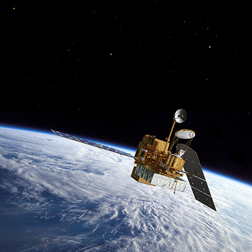
NASA/JAXA's GPM satellite. Image Credits: NASA/JAXA

The South Carolina Department of Transportation noted that hundreds of roads remain closed Monday across the state. On October 5, the National Weather Service (NWS) still carried Flash Flood warnings for portions of Charleston County, Berkeley County and Dorchester County all in southeastern South Carolina. NWS in Charleston, South Carolina said on Oct. 5 at 6:58 a.m. EDT, "low pressure off the northeast South Carolina coast will move slowly offshore through Tuesday [Oct. 6]."

GPM is the Global Precipitation Measurement mission core satellite, managed by both NASA and the Japan Aerospace Exploration Agency.

Related links:

The South Carolina Department of Transportation: http://dbw.scdot.org/RoadConditionsemr/default.aspx

National Weather Service (NWS): http://forecast.weather.gov/showsigwx.php?warnzone=SCZ052&warncounty=SCC015&firewxzone=SCZ052&local_place1=5%20Miles%20WNW%20Mount%20Pleasant%20SC&product1=Flash+Flood+Warning&lat=32.8588&lon=-79.9357#.VhKAKCuTLii

For more information about GPM (Global Precipitation Measurement), visit: http://www.nasa.gov/mission_pages/GPM/main/index.html and http://www.eorc.jaxa.jp/GPM/index_e.htm

Image (mentioned), Video (mentioned), Text, Credits: NASA's Goddard Space Flight Center/Hal Pierce.

Best regards, Orbiter.ch

Titan's Accent Mark


NASA - Cassini Mission to Saturn patch.

Oct. 5, 2015


A coincidence of viewing angle makes Pandora appear to be hovering over Titan, almost like an accent mark.

Little Pandora is much closer to Cassini than hazy Titan in this view. (Titan is nearly three times farther away.) Even so, Titan (3,200 miles or 5,150 kilometers across) dwarfs Pandora (50 miles or 81 kilometers across). This gives us some sense of the diversity in sizes, and shapes, of Saturn's many moons.

North on Titan is up and rotated 19 degrees to the right. The image was taken in visible green light with the Cassini spacecraft narrow-angle camera on July 4, 2015.

The view was acquired at a distance of approximately 1.2 million miles (1.9 million kilometers) from Titan. Image scale is 7 miles (12 kilometers) per pixel on Titan. Pandora is at a distance of 436,000 miles (698,000 kilometers) away from the spacecraft. The scale on Pandora is about 3 miles (4 kilometers) per pixel.

The Cassini mission is a cooperative project of NASA, ESA (the European Space Agency) and the Italian Space Agency. The Jet Propulsion Laboratory, a division of the California Institute of Technology in Pasadena, manages the mission for NASA's Science Mission Directorate, Washington. The Cassini orbiter and its two onboard cameras were designed, developed and assembled at JPL. The imaging operations center is based at the Space Science Institute in Boulder, Colorado.

For more information about the Cassini-Huygens mission visit http://saturn.jpl.nasa.gov or http://www.nasa.gov/cassini . The Cassini imaging team homepage is at http://ciclops.org and http://www.esa.int/Our_Activities/Space_Science/Cassini-Huygens

Image, Text, Credits: NASA/JPL-Caltech/Space Science Institute/Tony Greicius.

Greetings, Orbiter.ch

A Lunar Pox


ESA - SMART-1 Mission patch.

Oct. 5, 2015


The pockmarked landscape captured in this image from ESA’s SMART-1 mission is the surface of our Moon. Some of the many craters scattered across the lunar surface are clearly visible, records of the many impacts that have plagued it.

At the very centre of this image is the lunar north pole, captured in detail during ESA’s mission. The image shows the characteristic craters of the Moon, present in all shapes and sizes. The largest in view is Rozhdestvenskiy, sandwiched between Hermite to the northeast and Plaskett to the southwest.

SMART-1 orbited the moon from 2004 to 2006 collecting around 32 000 images of small areas. In order to create an image covering a large region like this one (60º in width) and showing the peaks and craters in context, hundreds of these individual images had to be pieced together into a mosaic – no easy task.

The biggest challenge in creating this mosaic was the changing lighting conditions. Despite the “dark side of the Moon” misnomer, both sides of the Moon do experience night and day in the same way. The far, or ‘dark’, side has ‘days’ of two weeks just like the nearside and is ‘dark’ only in the sense that it was unknown to humans before the arrival of space probes.

At the Moon’s north pole, pictured here, as is the case across all areas of the Moon, the Sun illuminates from different directions. As the Sun moves across the Moon’s sky, new areas are illuminated and shadows spread and move. This means that many of the images used for the mosaic are lit from different directions. This is why, on close inspection, faint squares can be found in the mosaic where two images of different illumination butt up against one another.

SMART-1

The overall effect however, was worth the labour, and the resulting image gives us a fresh perspective on our natural satellite. Astronomers can use images like these to identify peaks on the north pole that are almost always lit and areas deep inside its largest craters that may never see daylight. These areas of constant shadow are of particular interest because frozen within them could be water ice and clues to the history of the Solar System.

For more information about Smart-1, visit: http://www.esa.int/Our_Activities/Space_Science/SMART-1

Images, Text, Credits: ESA/SPACE-X (Space Exploration Institute). Acknowledgments: J. Manuel Fonseca, M. Costa & A. Mora (UNINOVA); B. Grieger & M. Almeida (ESA).

Greetings, Orbiter.ch

vendredi 2 octobre 2015

Hurricane Joaquin May Be Experiencing Eyewall Replacement in NASA Imagery


NASA - EOS Aqua Mission logo / NASA - ISS-RapidScat Mission logo.

Oct. 2, 2015

Joaquin - Atlantic Ocean

The National Hurricane Center indicated on October 2 that powerful Hurricane Joaquin may be experiencing eyewall replacement. The eye was visible on NASA Aqua satellite imagery October 1, but obscured twelve hours later. In addition, NASA's RapidScat instrument helped determine what part of the storm had the strongest winds.

An Inside Look at Joaquin's Strongest Winds


Image above: On Sept. 30 at 7:40 p.m. EDT, RapidScat saw strongest sustained winds in Joaquin's north and northwestern quadrants, stronger than 36 meters per second (80 mph/129.6 kph). Image Credits: NASA/JPL, Doug Tyler.

ISS-RapidScat instrument in action. Animation Credit: NASA

On September 30 at about 7:40 p.m. EDT, the International Space Station passed over Hurricane Joaquin in the Bahamas. The RapidScat instrument which flies aboard ISS measures sustained winds over open ocean and saw the hurricane's strongest sustained winds in the north and northwestern quadrants, stronger than 36 meters per second (80 mph/129.6 kph).

Visible Imagery

 
Image above: NASA's Aqua satellite captured this visible image of Hurricane Joaquin over Bahamas on Oct. 1 at 17:55 UTC (1:55 p.m. EDT). Image Credits: NASA Goddard MODIS Rapid Response Team.

The Moderate Resolution Imaging Spectroradiometer or MODIS instrument that flies aboard NASA's Aqua satellite captured a visible image of Hurricane Joaquin over Bahamas on Oct. 1 at 17:55 UTC (1:55 p.m. EDT). In the image, the eye was still visible. However, twelve hours later, visible imagery from NOAA's GOES-East satellite showed an eye obscured by clouds which forecasters at NOAA said could indicate that the eyewall of the storm was undergoing a replacement.

NASA's Aqua satellite. Image Credits: NASA/GSFC

Eyewall Replacement

In powerful hurricanes, a new eye begins to develop around the old eye. The new eye gradually decreases in diameter and replaces the old eye. When that happens, the intensity of the hurricane usually decreases. Despite the fact that eyewall replacement can mean a weakening in a powerful hurricane, it can also spread the hurricane force winds out over a larger area.

National Hurricane Center (NHC) Forecaster Brennan noted in the 5 a.m. EDT NHC discussion on October 2,"The eye of Joaquin has not been apparent in recent infrared imagery. The last pass of the Hurricane Hunter aircraft through the center around 04Z [midnight] showed indications of a double wind maximum at flight level, which could indicate that an eyewall replacement cycle is underway. The last report from the aircraft indicated that the central pressure still around 935 millibars. The initial intensity remains 115 knots pending the arrival of the next aircraft before 12Z [8 a.m. EDT]. Some fluctuations in intensity are possible during the next 12 to 24 hours due to eyewall replacement."

Warnings and Watches

On October 2, a Hurricane Warning was in effect for the central Bahamas, northwestern Bahamas including the Abacos, Berry Islands, Eleuthera, Grand Bahama Island, and New Providence, and The Acklins, Crooked Island, and Mayaguana in the southeastern Bahamas. A Hurricane Watch was in effect for Bimini and Andros Island.

In addition, a Tropical Storm Warning was in effect for the remainder of the southeastern Bahamas including the Turks and Caicos Islands, Andros Island, Cuban provinces of Camaguey, Los Tunas, Holguin, and Guantanamo.

Latest Update on Joaquin from the National Hurricane Center

At 8 a.m. EDT (1200 UTC), the center of Hurricane Joaquin was located near latitude 23.4 North, longitude 74.8 West. Joaquin was drifting toward the northwest near 3 mph (6 kph). The NHC expects a faster northward motion to begin later today (Oct. 2), followed by a turn toward the northeast and an increase in forward speed tonight and Saturday. On the forecast track, the core of the strongest winds of Joaquin will continue moving over portions of the central and northwestern Bahamas today. Joaquin will begin to move away from the Bahamas tonight and Saturday.

Maximum sustained winds are near 130 mph (215 kph) with higher gusts. Joaquin is a dangerous category 4 hurricane on the Saffir-Simpson Hurricane Wind Scale. Some fluctuations in intensity are possible during the next 24 hours. Slow weakening is expected to begin on Saturday.

Hurricane force winds extend outward up to 50 miles (85 km) from the center and tropical storm force winds extend outward up to 205 miles (335 km). The minimum central pressure just reported by an Air Force Reserve Hurricane Hunter aircraft is 937 millibars.

For the latest forecasts, visit the NHC website: http://www.nhc.noaa.gov.

The NHC noted that gradual weakening is forecast after October 3 as the cyclone encounters increasing southwesterly wind shear, but Joaquin is expected to remain a powerful hurricane for the next several days.

Related links:

NASA's Goddard Space Flight Center: http://www.nasa.gov/goddard

NASA's Aqua satellite: http://www.nasa.gov/mission_pages/aqua/index.html

ISS-RapidScat: http://www.jpl.nasa.gov/missions/iss-rapidscat/

Images (mentioned), Animation (mentioned), Text, Credits: NASA's Goddard Space Flight Center/Rob Gutro.

Best regards, Orbiter.ch

Curiosity's Drill Hole and Location are Picture Perfect


NASA - Mars Science Laboratory (MSL) patch.

October 2, 2015

On Tuesday, Sept. 29, NASA's Curiosity Mars rover drilled its eighth hole on Mars, and its fifth since reaching Mount Sharp one year ago. The drilling of the hole 2.6-inches (65 millimeters) deep in a rock the team labeled "Big Sky" is part of a multi-day, multi-step sequence that will result in the analysis of the Martian rock's ingredients in the rover's two onboard laboratories - the Chemistry and Mineralogy X-Ray diffractometer (CheMin) and the Sample Analysis at Mars (SAM) instrument suite.

Mount Sharp Comes In Sharply

Image above: This composite image looking toward the higher regions of Mount Sharp was taken on September 9, 2015, by NASA's Curiosity rover. In the foreground -- about 2 miles (3 kilometers) from the rover -- is a long ridge teeming with hematite, an iron oxide. Image Credits: NASA/JPL-Caltech/MSSS.

"With Big Sky, we found the ordinary sandstone rock we were looking for," said Curiosity Project Scientist Ashwin Vasavada. "It also happens to be relatively near sandstone that looks as though it has been altered by fluids -- likely groundwater with other dissolved chemicals. We are hoping to drill that rock next, compare the results, and understand what changes have taken place."

The analyses of the Big Sky rock-powder samples by CheMin and SAM will occur over the next week. Meanwhile, the team will be turning the rover's attention and its wheels towards the second rock, where the sample analysis process will begin anew.

Postcard from Mars. Image Credits: NASA/JPL-Caltech/MSSS.

Curiosity is currently on the lower slopes of Mount Sharp in a region covered in sandstone called the Stimson Unit. Two weeks ago, still in the same general vicinity, Curiosity took a pair of long-range images toward higher regions of the mountain. In the foreground -- about 2 miles (3 kilometers) from the rover -- is a long ridge teeming with hematite, an iron oxide. Just beyond is an undulating plain rich in clay minerals. And just beyond that are a multitude of rounded buttes, all high in sulfate minerals. The changing mineralogy in these layers of Mount Sharp suggests a changing environment in early Mars, though all involve exposure to water billions of years ago. The Curiosity team hopes to be able to explore these diverse areas in the months and years ahead. Farther back in the image are striking, light-toned cliffs in rock that may have formed in drier times and now are heavily eroded by winds.

Curiosity selfie with holes. Image Credits: NASA/JPL-Caltech/MSSS

"The only thing more stunning than these images is the thought that Curiosity will be driving through those lower hills one day," Vasavada said. "We couldn't help but send a postcard back to all those following her journey."

NASA's Mars Science Laboratory Project is using Curiosity to assess ancient habitable environments and major changes in Martian environmental conditions. NASA's Jet Propulsion Laboratory, a division of Caltech, built the rover and manages the project for NASA's Science Mission Directorate in Washington.

For more information about Curiosity, visit http://www.jpl.nasa.gov/msl , http://www.nasa.gov/msl and http://mars.jpl.nasa.gov/msl/. You can follow the mission on Facebook at http://www.facebook.com/marscuriosity and on Twitter at http://www.twitter.com/marscuriosity.

Images (mentioned), Text, Credits: NASA/JPL/DC Agle/Guy Webster.

Greetings, Orbiter.ch