mercredi 4 septembre 2019

NASA Estimates Hurricane Dorian’s Massive Bahama Rainfall Totals


NASA & JAXA - Global Precipitation Measurement (GPM) patch.

Sep. 04, 2019

Dorian – Atlantic Ocean

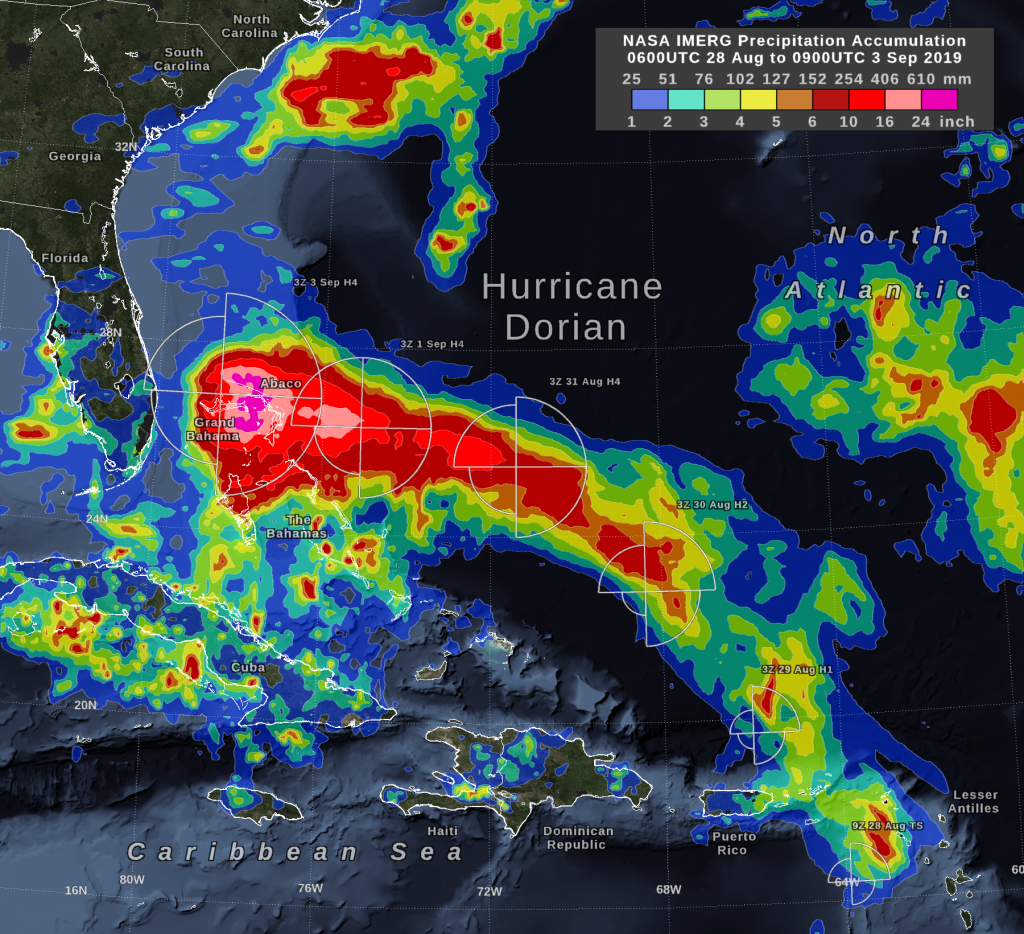
Hurricane Dorian dropped excessive rainfall on the Bahamas and NASA calculated the rainfall the storm generated.


Image above: This image shows NASA IMERG estimated rainfall accumulations for the region of the Bahamas affected by Hurricane Dorian from Aug. 31 to Sept. 4. The imagery shows rainfall exceeded 36 inches in an area that included parts of Grand Bahama Island and Abaco Island. Image Credits: NASA Goddard.

“By Wednesday morning, September 4, the rain accumulation from Hurricane Dorian exceeded 36 inches in an area that included parts of Grand Bahama Island and Abaco Island,” said Owen Kelley, researcher at NASA Goddard. “By that time, the Dorian’s center was north of the Bahamas and was moving further north, approximately parallel to Florida’s east coast.”

NASA Estimating Rainfall

NASA has the ability to peer under the clouds of a tropical cyclone and estimate the rainfall rates occurring in a storm or how much rain has fallen. Rainfall imagery was generated using the Integrated Multi-satEllite Retrievals for GPM or IMERG product at NASA’s Goddard Space Flight Center in Greenbelt, Maryland. These near-realtime rain estimates come from the NASA IMERG algorithm, which combines observations from a fleet of satellites in the GPM or Global Precipitation Measurement mission constellation of satellites, and is calibrated with measurements from the GPM Core Observatory as well as rain gauge networks around the world. The measurements are done in near-real time, to provide global estimates of precipitation every 30 minutes.

The storm-total rainfall at a particular location varies with the forward speed of the hurricane, with the size of the hurricane’s wind field, and with how vigorous the updrafts are inside the hurricane.

 Global Precipitation Measurement (GPM) Core satellite. Image Credits: NASA/JAXA

During the past day, the maximum sustained surface winds speed (Dorian’s intensity) decreased from category 5 to category 2 on the Saffir-Simpson scale. At the same time, the geographic extent of tropical-storm strength winds increased significantly.

Warnings and Watches on Sept. 4

NOAA’s National Hurricane Center (NHC) posted many warnings and watches as Dorian continues to move north along the U.S. East Coast.

A Storm Surge Warning is in effect for Sebastian Inlet, FL to Surf City, NC. A Storm Surge Watch is in effect from north of Surf City, NC to Poquoson, VA, including Hampton Roads, Pamlico and Albemarle Sounds and the Neuse and Pamlico Rivers.

A Hurricane Warning is in effect for Volusia/Brevard County, FL line to Ponte Vedra Beach, FL and from north of the Savannah River to Surf City, NC. A Hurricane Watch is in effect from north of Ponte Vedra Beach, FL to the Savannah River, from north of Surf City, NC to the North Carolina/Virginia border and for the Albemarle and Pamlico Sounds.

A Tropical Storm Warning is in effect from the Sebastian Inlet, FL to the Volusia/Brevard County, FL line and from north of Ponte Vedra Beach, FL to Savannah River. A Tropical Storm Watch is in effect from the North Carolina/Virginia border to Chincoteague, VA and for Chesapeake Bay from Smith Point southward.

NHC:  Dorian’s Status on Sept. 4

At 8 EDT (1200 UTC) on Sept. 4, NHC said the center of Hurricane Dorian was located near latitude 29.5 degrees north and longitude 79.6 degrees west. Dorian is about 95 miles (155 km) east-northeast of Daytona Beach, Florida.

Because hurricane-force winds extend outward up to 60 miles (95 km) from the center, and tropical-storm-force winds extend outward up to 175 miles (280 km), Daytona was experiencing those tropical-storm-force winds at 8 a.m. EDT.

Dorian is moving toward the north-northwest near 8 mph (13 kph), and a northwest or north-northwest motion is expected through this morning. Maximum sustained winds are near 105 mph (165 kph) with higher gusts. Some weakening is expected during the next couple of days. However, Dorian is expected to remain a powerful hurricane during the next few days. The minimum central pressure reported by an Air Force Reserve Unit Hurricane Hunter aircraft is 964 millibars.

NOAA’s Forecasts

NHC said, “A turn toward the north is forecast by this evening, followed by a turn toward the north-northeast on Thursday morning.  On this track, the core of Hurricane Dorian will move dangerously close to the Florida east coast and the Georgia coast through tonight.  The center of Dorian is forecast to move near or over the coast of South Carolina and North Carolina Thursday through Friday morning.”

Related article:

NASA’s IMERG Estimates Hurricane Dorian’s Rain
https://orbiterchspacenews.blogspot.com/2019/09/nasas-imerg-estimates-hurricane-dorians.html

For updated forecasts, visit NOAA’s NHC: http://www.nhc.noaa.gov/

Global Precipitation Measurement (GPM): https://www.nasa.gov/mission_pages/GPM/main/index.html

For more about NASA’s IMERG, visit: https://pmm.nasa.gov/gpm/imerg-global-image

Images (mentioned), Text, Credits: NASA’s Goddard Space Flight Center, by Owen Kelley/Rob Gutro.

Greetings, Orbiter.ch

An Infrared View of the M81 Galaxy


NASA - Spitzer Space Telescope patch.

Sept. 4, 2019


Located in the northern constellation of Ursa Major, which also includes the Big Dipper, nearby galaxy Messier 81 is easily visible through binoculars or a small telescope. M81 is located at a distance of 12 million light-years.

M81 was one of the first publicly released datasets soon after the launch of the Spitzer Space Telescope in August 2003. On the occasion of Spitzer's 16th anniversary this new image revisits this iconic object with extended observations and improved processing.

This Spitzer infrared image is a composite mosaic combining data from the Infrared Array Camera (IRAC) at wavelengths of 3.6/4.5 microns (blue/cyan) and 8 microns (green) with data from the Multiband Imaging Photometer (MIPS) at 24 microns (red).

The 3.6-micron near-infrared data (blue) traces the distribution of stars, although the Spitzer image is virtually unaffected by obscuring dust and reveals a very smooth stellar mass distribution, with the spiral arms relatively subdued.

As one moves to longer wavelengths, the spiral arms become the dominant feature of the galaxy. The 8-micron emission (green) is dominated by infrared light radiated by hot dust that has been heated by nearby luminous stars. Dust in the galaxy is bathed by ultraviolet and visible light from nearby stars. Upon absorbing an ultraviolet or visible-light photon, a dust grain is heated and re-emits the energy at longer infrared wavelengths. The dust particles are composed of silicates (chemically similar to beach sand), carbonaceous grains and polycyclic aromatic hydrocarbons and trace the gas distribution in the galaxy. The well-mixed gas (which is best detected at radio wavelengths) and dust provide a reservoir of raw materials for future star formation.

Related article:

Sixteen Images for Spitzer's Sweet 16
https://orbiterchspacenews.blogspot.com/2019/08/sixteen-images-for-spitzers-sweet-16.html

Spitzer Space Telescope: https://www.nasa.gov/mission_pages/spitzer/main/index.html

Image, Text,  Credits: NASA/Yvette Smith/JPL-Caltech.

Greetings, Orbiter.ch

mardi 3 septembre 2019

NASA’s IMERG Estimates Hurricane Dorian’s Rain


NASA & JAXA - Global Precipitation Measurement (GPM) patch.

September 3, 2019

Dorian – Atlantic Ocean

In the early hours of Tuesday, September 3, Hurricane Dorian had been stationary over the island of Grand Bahama for 18 hours, most of the time as a category 5 hurricane. Storm-total rain accumulation over parts of Grand Bahama and Abaco Islands have exceeded 24 inches according to NASA satellite-based estimates.


Image above: NASA’s IMERG storm-total rain accumulation over parts of Grand Bahama and Abaco islands have exceeded 24 inches according to NASA satellite-based estimates. The graphic also shows the distance that tropical-storm force (39 mph) winds extend from Hurricane Dorian’s low-pressure center, as reported by the National Hurricane Center. The symbols H and TS represent a hurricane of various Saffir-Simpson categories or a tropical storm, respectively. Image Credits: NASA Goddard.

On early Tuesday morning, Dorian’s central pressure had risen and its wind intensity had dropped to category 4 on the Saffir-Simpson scale.  In addition, Dorian had experienced an eyewall replacement cycle on September 2, so by Tuesday morning Sept. 3, the geographic extent of its tropical-storm-force winds had expanded.

These rain estimates come from the NASA IMERG algorithm, which combines observations from a fleet of satellites, in near-realtime, to provide global estimates of precipitation every 30 minutes. The storm-total rainfall at a particular location varies with the forward speed of the hurricane, with the size of the hurricane’s wind field, and with how vigorous the updrafts are inside of the hurricane’s eyewall.

IMERG, or the Integrated Multi-satellitE Retrievals for GPM (IMERG) data product is generated by NASA’s Precipitation Processing System every half hour with a 6 hour latency from the time of data acquisition. It is produced using data from the satellites in the GPM or Global Precipitation Measurement mission constellation of satellites, and is calibrated with measurements from the GPM Core Observatory as well as rain gauge networks around the world.

IMERG is an example of the research role that NASA has in hurricanes  – developing observational tools and building computer models to better understand the behavior of tropical cyclones. NASA’s research data is utilized by NOAA’s National Hurricane Center (NHC) to enhance their forecasts.

On Tuesday, September 3, 2019, at 8 a.m. EDT (1200 UTC), NHC reported at the eye of Hurricane Dorian was located by reconnaissance aircraft and NOAA Doppler radar near latitude 27.1 degrees North and longitude 78.4 degrees West. NHC said Dorian is beginning to move northwestward at about 1 mph (2 kph), and a slightly faster motion toward the northwest or north-northwest is expected later today and tonight.

Global Precipitation Measurement (GPM) Core satellite. Image Credits: NASA/JAXA

At present maximum sustained winds are near 120 mph (195 kph) with higher gusts.  Dorian is a category 3 hurricane on the Saffir-Simpson Hurricane Wind Scale.  Dorian is expected to remain a powerful hurricane during the next couple of days. Hurricane-force winds extend outward up to 45 miles (75 km) from the center, and tropical-storm-force winds extend outward up to 160 miles (260 km). The latest minimum central pressure reported by reconnaissance aircraft is 952 mb (28.11 inches).

NHC forecasts a turn toward the north by Wednesday evening, followed by a turn to the north-northeast Thursday morning.  On this track, the core of extremely dangerous Hurricane Dorian will gradually move north of Grand Bahama Island through this evening. The hurricane will then move dangerously close to the Florida east coast late today through Wednesday evening, very near the Georgia and South Carolina coasts Wednesday night and Thursday, and near or over the North Carolina coast late Thursday.

For updated forecasts, visit: http://www.nhc.noaa.gov/

Global Precipitation Measurement (GPM): https://www.nasa.gov/mission_pages/GPM/main/index.html

For more about NASA’s IMERG, visit: https://pmm.nasa.gov/gpm/imerg-global-image

Images (mentioned), Text, Credits: NASA’s Goddard Space Flight Center, by Owen Kelly / with NOAA’s NHC Update.

Greetings, Orbiter.ch

As Hurricane Dorian Churns Below, Expedition 60 Continues Investigations, Training Above


ISS - Expedition 60 Mission patch.

September 3, 2019

After a quiet, off-duty day for the crew of Expedition 60 on Labor Day, operations supporting science for long-duration human space exploration and upcoming spaceship movements ramped up on the International Space Station.

Cosmonauts Alexey Ovchinin and Alexander Skvortsov are busy packing the Soyuz MS-14 with return gear before the vehicle parachutes back to Earth — without crew inside — this Friday, Sept. 6. Then, days later, the H-II Transfer Vehicle-8 (HTV-8) is scheduled to launch on Sept. 10 from the Tanegashima Space Center in Japan. Its four-day journey to the orbiting laboratory will deliver 6.5 tons of new supplies and cargo.


Image above: Astronaut Christina Koch of the International Space Station captured this image of Hurricane Dorian outside the space station’s windows the morning of Sept. 2, 2019. Image Credit: NASA.

NASA crewmates Christina Koch and Andrew Morgan continued prepping for the robotic capture of HTV-8, reviewing procedures to ensure a smooth installation of the spaceship to the Harmony module for its month-long visit. 

Koch also performed Main Bus Switching Unit (MSBU) maintenance with fellow astronaut Nick Hague, afterward using a laptop connected to the MSBU with special test cables for a functional checkout of the repaired unit. 

Science investigations continue in earnest, with Luca Parmitano of ESA (European Space Agency) conducting VEG-04 operations and additional Veggie training, also capturing light measurements for the novel experiment that seeks to learn about the impact of light quality and fertilizer on leafy crops grown in microgravity.

Morgan and Parmitano spent time setting up and recording for ISS Experience, which documents life and research operations aboard the space station in cinematic virtual reality. Meanwhile, Koch worked with Microgravity Crystals, removing crystal plates from the Space Automated Byproduct Laboratory (SABL) to observe and photograph the sample wells under microscope before returning them to the SABL.

Views of Hurricane Dorian from the International Space Station - September 3, 2019

Extremely dangerous Hurricane Dorian continues to churn in the Atlantic Ocean 250 miles below, with crew members getting an unparalleled view of the storm as it begins to move from an almost stationary position over the northwestern Bahamas. Now a high category 2 hurricane with maximum sustained winds near 110 mph with occasional higher gusts, it will continue to crawl northwestward at about 2 mph, with a slightly faster motion toward the northwest, or north-northwest, expected later today and tonight. The storm is expected to come perilously close to Florida’s east coast late today through Wednesday evening and skirt by Georgia and South Carolina’s coastlines Wednesday night and Thursday.

Related links:

Expedition 60: https://www.nasa.gov/mission_pages/station/expeditions/expedition60/index.html

VEG-04: https://www.nasa.gov/mission_pages/station/research/experiments/explorer/search.html?#q=%22veg-04%22&i=&p=&c=&g=&s=

ISS Experience: https://www.nasa.gov/mission_pages/station/research/experiments/explorer/Investigation.html?#id=7877

Microgravity Crystals: https://iss-www.jsc.nasa.gov/pst/External_v2/Investigation.html#id=7977

Space Automated Byproduct Laboratory (SABL): https://iss-www.jsc.nasa.gov/pst/External_v2/Facility.html?#id=1148

Space Station Research and Technology: https://www.nasa.gov/mission_pages/station/research/index.html

International Space Station (ISS): https://www.nasa.gov/mission_pages/station/main/index.html

Image (mentioned), Video (NASA), Text, Credits: NASA/Catherine Williams.

Best regards, Orbiter.ch

ESA spacecraft dodges large constellation


ESA - European Space Agency patch.

3 September 2019

Aeolus was recently manoeuvred to avoid collision with a satellite in a constellation

- For the first time, ESA has performed a 'collision avoidance manoeuvre' to protect one of its spacecraft from colliding with a satellite in a large constellation.

- On Monday morning, the Agency's Aeolus Earth observation satellite fired its thrusters, moving it off a potential collision course with a SpaceX satellite in the Starlink constellation.

- Constellations are fleets of hundreds up to thousands of spacecraft working together in orbit. They are expected to become a defining part of Earth’s space environment in the next few years.

- As the number of satellites in space dramatically increases, close approaches between two operated spacecraft will occur more frequently. Compared with such 'conjunctions' with space debris – non-functional objects including dead satellites and fragments from past collisions – these require coordination efforts, to avoid conflicting actions.

- Today, the avoidance process between two operational satellites is largely manual and ad hoc – and will no longer be practical as the number of alerts rises with the increase in spaceflight.

- “This example shows that in the absence of traffic rules and communication protocols, collision avoidance depends entirely on the pragmatism of the operators involved,” explains Holger Krag, Head of Space Safety at ESA.

- “Today, this negotiation is done through exchanging emails - an archaic process that is no longer viable as increasing numbers of satellites in space mean more space traffic.”

- ESA is proposing an automated risk estimation and mitigation initiative as part of its space safety activities. This will provide and demonstrate the types of technology needed to automate the collision avoidance process, allowing machine generated, coordinated and conflict-free manoeuvre decisions to speed up the entire process – something desperately needed to protect vital space infrastructure in the years to come.

What happened?

Data is constantly being issued by the 18th Space Control Squadron of the US Air Force, who monitor objects orbiting in Earth’s skies, providing information to operators about any potential close approach.

With this data, ESA and others are able to calculate the probability of collision between their spacecraft and all other artificial objects in orbit.

About a week ago, the US data suggested a potential ‘conjunction’ at 11:02 UTC on Monday, 2 September, between ESA’s Aeolus satellite and Starlink44 – one of the first 60 satellites recently launched in SpaceX’s mega constellation, planned to be a 12 000 strong fleet by mid-2020.

Predicted conjunction between Aeolus and Starlink 44

Experts in ESA’s Space Debris Office worked to calculate the collision probability, combining information on the expected miss distance, conjunction geometry and uncertainties in orbit information.

As days passed, the probability of collision continued to increase, and by Wednesday 28 August the team decided to reach out to Starlink to discuss their options. Within a day, the Starlink team informed ESA that they had no plan to take action at this point.

ESA’s threshold for conducting an avoidance manoeuvre is a collision probability of more than 1 in 10 000, which was reached for the first time on Thursday evening.

At ESA's space debris facility

An avoidance manoeuvre was prepared which would increase Aeolus’ altitude by 350 m, ensuring it would comfortably pass over the other satellite, and the team continued to monitor the situation.

On Sunday, as the probability continued to increase, the final decision was made to implement the manoeuvre, and the commands were sent to the spacecraft from ESA’s mission control centre in Germany.

At this moment, chances of collision were around 1 in 1000, 10 times higher than the threshold.

On Monday morning, the commands triggered a series of thruster burns at 10:14, 10:17 and 10:18 UTC, half an orbit before the potential collision.

Aeolus – understanding Earth’s winds

About half an hour after the conjunction was predicted, Aeolus contacted home as expected. This was the first reassurance that the manoeuvre was correctly executed and the satellite was OK.

Since then, teams on the ground have continued to receive scientific data from the spacecraft, meaning operations are back to normal science-gathering mode.

Contact with Starlink early in the process allowed ESA to take conflict-free action later, knowing the second spacecraft would remain where models expected it to be.

New space

Since the first satellite launch in 1957, more than 5500 launches have lifted over 9000 satellites into space. Of these, only about 2000 are currently functioning, which explains why 90% of ESA’s avoidance manoeuvres are the result of derelict and uncontrollable ‘space debris’.

In the years to come, constellations of thousands of satellites are set to change the space environment, vastly increasing the number of active, operational spacecraft in orbit.

A satellite mega-constellation

This new technology brings enormous benefits to people on Earth, including global internet access and precise location services, but constellations also bring with them challenges in creating a safe and sustainable space environment.

Space rules

“No one was at fault here, but this example does show the urgent need for proper space traffic management, with clear communication protocols and more automation,” explains Holger.

“This is how air traffic control has worked for many decades, and now space operators need to get together to define automated manoeuvre coordination.”

Autonomous spaceflight

As the number of satellites in orbit rapidly increases, today's 'manual' collision avoidance process will become impossible, and automated systems are becoming necessary to protect our space infrastructure.

Collision avoidance manoeuvres take a lot of time to prepare – from determining the future orbital positions of functioning spacecraft, to calculating the risk of collision and the many possible outcomes of different actions.

ESA is preparing to automate this process using artificial intelligence, speeding up the processes of data crunching and risk analysis, from the initial warning of a potential conjunction to the satellite finally moving out of the way.

Space Safety & Security

Such use of space-based communication links can save precious time when sending manoeuvre commands at the last minute.

Under its Space Safety activities, ESA plans to invest in technologies required to automatically process collision warnings, coordinate manoeuvres with other operators and send the commands to spacecraft entirely automatically, ensuring the benefits of space can continue to be enjoyed for generations to come.

The use of space-based communication links to transmit commands can help to save precious time in order to uplink a manoeuvre decision in the last minute.

Related links:

ESA’s Space Debris Office: http://www.esa.int/Our_Activities/Space_Safety/Space_Debris

Space Safety: http://www.esa.int/Our_Activities/Space_Safety/Space_Safety

In-orbit serving vehicle: http://www.esa.int/Our_Activities/Space_Safety/ESA_s_e.Deorbit_debris_removal_mission_reborn_as_servicing_vehicle

ESA’s mission control centre: http://www.esa.int/About_Us/ESOC

Images, Text, Credits: ESA/R. Palmari/ATG medialab.

Greetings, Orbiter.ch

Space Station science return and spacecraft shuffle


ESA - Beyond Mission patch.

3 September 2019

ESA astronaut Luca Parmitano’s Beyond mission has kicked into high gear during the last two weeks. He has been keeping the International Space Station running smoothly as well as working remotely with European researchers – with even Luca’s mealtimes the subject of experimental scrutiny.

Space Station view

As an amateur triathlete, Luca knows how crucial nutrition is for healthy and efficient living. Getting meals right is an aspect of mission design, so the Nutrition Monitoring for the International Space Station (NutrISS) experiment is tracking Luca’s energy balance.

ESA astronaut Paolo Nespoli using EveryWear for nutrition monitoring

Using the EveryWear astronaut app and a ‘bioelectric impedance’ device to measure his bodily conductivity, Luca has been tracking his fat to mass ratio. The science teams on Earth hope that a carefully-tailored high-protein diet could limit the typical microgravity-driven loss of bone and muscle.

Spacecraft shuffle

The Soyuz MS-14 spacecraft originally expected to arrive on 24 August, carrying supplies and the Russian ‘Fedor’ robot, had its arrival called off due to a problem with the automated docking system. A different port was selected for what turned out to be a successful follow-up docking, but first it needed to be vacated.

Luca during Soyuz redocking

On 26 August US astronaut Andrew Morgan and Russian cosmonaut Alexander Skvortsov accordingly moved the Soyuz MS-13 in a half-hour spaceflight. The Space Station solar arrays no longer align to the Sun during such manoeuvres, so electrical power needed to be conserved in advance of this transfer.

Many facilities were temporarily switched off, including Europe’s commercial ICE Cubes platform currently hosting three experiments: a test of off-the-shelf computer parts, an art installation and an ESA investigation into orbital cyber security.

Exit the Dragon

A fourth ICE Cubes experiment was removed earlier in the month after it completed its operations. SpectroDemo – a new type of spectrometer that could be used on an ESA exobiology experiment, was tested to see if the technology is robust and fit for space science.

Tuesday 27 August saw the departure of Dragon and the end of the spaceflight part of many more European experiments. The samples from the Amyloid Aggregation experiment looking into how protein accumulates in brain cells were removed from the Station’s –80°C freezer and packed for return to Earth.

Flight of the Dragon

The proteins and exobiology instruments flying on Dragon were accompanied by microbes that had also been waiting in the freezer for their return trip to Earth. The BioRock experiment was the first investigation into using organisms to mine for resources in space. Microbes were set lose on a basalt plate in a closed container.

More organisms, in the form of algae, were also flown home, that had been part of German Aerospace Center DLR’s PhotoBioreactor experiment that aimed to convert carbon dioxide to breathable oxygen and edible algae – five samples splashed down in the Pacific Ocean.

Taking photos of BioRock

Lastly France’s space agency CNES finished a second investigation into materials for germ-resistant spacecraft. The Matiss-2 experiment was placed in Europe’s space laboratory Columbus for just under a year collecting dust and bacteria. Researchers will now analyse the surfaces to see which materials are least hospitable to unwanted bacteria – focussing on materials that expel water.

Matiss-2 in Columbus

Time for an upgrade

Luca and his crewmates have also been helping keep onboard hardware running smoothly – an unglamorous but essential aspect of spaceflight. They prepared laptops for upgrades, installed updated firmware in the  Kubik centrifuge-incubator, prepared the AstroPi educational mini-computers to run new student code and switched over laptop batteries as part of the regular health check of the BioLab glovebox system.

Luca working with Fluid Science Laboratory

Luca and his crewmates have also been helping keep onboard hardware running smoothly – an unglamorous but essential aspect of spaceflight. They prepared laptops for upgrades, installed updated firmware in the space station.

Related links:

Nutrition Monitoring for the International Space Station (NutrISS): https://lsda.jsc.nasa.gov/Experiment/exper/19002

EveryWear astronaut app: http://www.esa.int/spaceinimages/Images/2017/09/EveryWear_app

Europe’s commercial ICE Cubes platform: http://www.icecubesservice.com/

ESA investigation into orbital cyber security: http://www.esa.int/spaceinimages/Images/2019/07/Cryptography_ICE_Cube_experiment

SpectroDemo: http://www.esa.int/spaceinimages/Images/2019/05/Exobiology_in_a_box

Amyloid Aggregation experiment: http://www.esa.int/spaceinimages/Images/2019/08/Amyloid_aggregation

BioRock: http://www.esa.int/spaceinimages/Images/2019/03/BioRock

PhotoBioreactor: https://www.dlr.de/dlr/en/desktopdefault.aspx/tabid-11017/1813_read-26324/

Kubik: https://www.esa.int/spaceinimages/Images/2018/02/Kubik_on_Space_Station

AstroPi: http://www.astropi.org/

BioLab glovebox: https://www.esa.int/Our_Activities/Human_and_Robotic_Exploration/Columbus/Biolab

Images, Text, Credits: ESA/NASA/L. Parmitano.

Best regards, Orbiter.ch

lundi 2 septembre 2019

Sensor used at CERN could help gravitational-wave hunters


CERN - European Organization for Nuclear Research logo.

Sept. 2, 2019

A new seismic device developed by CERN and JINR is now being tested at the Advanced Virgo detector


Image above: Aerial view of the Advanced Virgo detector, where a precision laser interferometer used at CERN was installed and is being tested (Image: Virgo collaboration).

It started with a relatively simple goal: create a prototype for a new kind of device to monitor the motion of underground structures at CERN. But the project – the result of a collaboration between CERN and the Joint Institute for Nuclear Research (JINR) in Dubna, Russia – quickly evolved. The prototype turned into several full-blown devices that can potentially serve as early warning systems for earthquakes and can be used to monitor other seismic vibrations. What’s more, the devices, called precision laser inclinometers, can be used at CERN and beyond. The researchers behind the project are now testing one device at the Advanced Virgo detector, which recently detected gravitational waves – tiny ripples in the fabric of space-time that were predicted by Einstein a century ago. If all goes to plan, this device could help gravitational-wave hunters minimise the noise that seismic events cause on the waves’ signal.

Unlike traditional seismometers, which detect ground motions through their effect on weights hanging from springs, the precision laser inclinometer (PLI) measures their effect on the surface of a liquid. The measurement is done by pointing laser light at a liquid and seeing how it is reflected. Compared to weight–spring seismometers, the PLI can detect angular motion in addition to translational motion (up-and-down and side-to-side), and it can pick up low-frequency motion with a very high precision.

“The PLI is extremely sensitive; it can even detect the waves on Lake Geneva on windy days,” says principal investigator Beniamino Di Girolamo from CERN. “It can pick up seismic motion that has a frequency between 1 mHz and 12.4 Hz with a sensitivity of 2.4 × 10−5 μrad/Hz½,” explains co-principal investigator Julian Budagov from JINR. “This is equivalent to measuring a vertical displacement of 24 picometres (24 trillionths of a metre) over a distance of 1 metre,” adds co-principal investigator Mikhail Lyablin, also from JINR.

The team assembled and tested the PLI prototype at JINR and at CERN’s TT1 tunnel. It performed so well that it showed the potential to be a helpful early warning seismic system for the High-Luminosity Large Hadron Collider (HL-LHC) and other machines and experiments. The Large Hadron Collider and its proton beams are extremely robust to seismic activity, but the HL-LHC will use narrower beams to increase the number of proton–proton collisions and as a result the potential for particle-physics discoveries. This means beams are more likely to go off centre in the event of a high-magnitude earthquake with an epicentre relatively close to CERN. PLIs located at several points around the machine could serve as early warning systems for such events.


Graphics above: The PLI (bottom two plots) picked up the same signals as devices already installed at Virgo (top two plots) for an earthquake in Northern Italy on 17 August (Image: Beniamino Di Girolamo/CERN).

Given the PLI’s potential, the HL-LHC project has provided support to the team for the constructionof  several new PLIs. One is already installed at the Garni Seismic Observatory in Armenia and another has been deployed with the support of CERN’s Knowledge Transfer group and Italy’s INFN institute to the European Gravitational Observatory in Italy, where Advanced Virgo is located. The Virgo PLI is the result of a collaboration that started after the APPEC conference in November 2018, triggered by the JINR Director-General and encouraged by CERN Management. The collaboration went so smoothly that, less than a year later, the Virgo PLI was tested.

The results from the first tests are encouraging. With just 15 minutes of data taken on 6 August, the PLI picked up the same signals as devices already installed at Virgo, and from that day onwards it started running continuously and detected several small-magnitude earthquakes. The Virgo and PLI teams are now setting up the flow of data from the PLI to the Virgo data system. This will make it easier to compare data from different seismic devices and to assess the PLI’s potential impact on Virgo’s operation and detection of gravitational waves. “Virgo and the two LIGO detectors in the US have recently begun another search for gravitational waves, one that will reach deeper into the universe than previous searches,” says former Virgo spokesperson Fulvio Ricci from La Sapienza University, Rome. “We’re confident that the PLI can play a part in this important search,” he added.

Note:

CERN, the European Organization for Nuclear Research, is one of the world’s largest and most respected centres for scientific research. Its business is fundamental physics, finding out what the Universe is made of and how it works. At CERN, the world’s largest and most complex scientific instruments are used to study the basic constituents of matter — the fundamental particles. By studying what happens when these particles collide, physicists learn about the laws of Nature.

The instruments used at CERN are particle accelerators and detectors. Accelerators boost beams of particles to high energies before they are made to collide with each other or with stationary targets. Detectors observe and record the results of these collisions.

Founded in 1954, the CERN Laboratory sits astride the Franco–Swiss border near Geneva. It was one of Europe’s first joint ventures and now has 23 Member States.

Related links:

High-Luminosity Large Hadron Collider (HL-LHC): https://home.cern/science/accelerators/high-luminosity-lhc

CERN’s Knowledge Transfer group: https://kt.cern/

APPEC conference in November 2018: https://indico.desy.de/indico/event/20154

For more information about European Organization for Nuclear Research (CERN), Visit: https://home.cern/

Image (mentioned), Graphics (mentioned), Text, Credits: CERN/Ana Lopes.

Best regards, Orbiter.ch