jeudi 18 février 2021

Touchdown! NASA's Mars Perseverance Rover Safely Lands on Red Planet


NASA - Mars 2020 Perseverance Rover logo.


Feb. 18, 2021

The largest, most advanced rover NASA has sent to another world touched down on Mars Thursday, after a 203-day journey traversing 293 million miles (472 million kilometers). Confirmation of the successful touchdown was announced in mission control at NASA’s Jet Propulsion Laboratory in Southern California at 3:55 p.m. EST (12:55 p.m. PST).


Image above: Members of NASA’s Perseverance Mars rover team watch in mission control as the first images arrive moments after the spacecraft successfully touched down on Mars, Thursday, Feb. 18, 2021, at NASA's Jet Propulsion Laboratory in Pasadena, California. A key objective for Perseverance’s mission on Mars is astrobiology, including the search for signs of ancient microbial life. The rover will characterize the planet’s geology and past climate, pave the way for human exploration of the Red Planet, and be the first mission to collect and cache Martian rock and regolith. Image Credits: NASA/Bill Ingalls.

Packed with groundbreaking technology, the Mars 2020 mission launched July 30, 2020, from Cape Canaveral Space Force Station in Florida. The Perseverance rover mission marks an ambitious first step in the effort to collect Mars samples and return them to Earth.  

“This landing is one of those pivotal moments for NASA, the United States, and space exploration globally – when we know we are on the cusp of discovery and sharpening our pencils, so to speak, to rewrite the textbooks,” said acting NASA Administrator Steve Jurczyk. “The Mars 2020 Perseverance mission embodies our nation’s spirit of persevering even in the most challenging of situations, inspiring, and advancing science and exploration. The mission itself personifies the human ideal of persevering toward the future and will help us prepare for human exploration of the Red Planet in the 2030s.”

Perseverance Arrives at Mars Feb. 18 2021 (Mission Trailer)

About the size of a car, the 2,263-pound (1,026-kilogram) robotic geologist and astrobiologist will undergo several weeks of testing before it begins its two-year science investigation of Mars’ Jezero Crater. While the rover will investigate the rock and sediment of Jezero’s ancient lakebed and river delta to characterize the region’s geology and past climate, a fundamental part of its mission is astrobiology, including the search for signs of ancient microbial life. To that end, the Mars Sample Return campaign, being planned by NASA and ESA (European Space Agency), will allow scientists on Earth to study samples collected by Perseverance to search for definitive signs of past life using instruments too large and complex to send to the Red Planet.

“Because of today’s exciting events, the first pristine samples from carefully documented locations on another planet are another step closer to being returned to Earth,” said Thomas Zurbuchen, associate administrator for science at NASA. “Perseverance is the first step in bringing back rock and regolith from Mars. We don’t know what these pristine samples from Mars will tell us. But what they could tell us is monumental – including that life might have once existed beyond Earth.”

Some 28 miles (45 kilometers) wide, Jezero Crater sits on the western edge of Isidis Planitia, a giant impact basin just north of the Martian equator. Scientists have determined that 3.5 billion years ago the crater had its own river delta and was filled with water.

The power system that provides electricity and heat for Perseverance through its exploration of Jezero Crater is a Multi-Mission Radioisotope Thermoelectric Generator, or MMRTG. The U.S. Department of Energy (DOE) provided it to NASA through an ongoing partnership to develop power systems for civil space applications.

NASA’s Mars Helicopter Ingenuity (Trailer)

Equipped with seven primary science instruments, the most cameras ever sent to Mars, and its exquisitely complex sample caching system – the first of its kind sent into space – Perseverance will scour the Jezero region for fossilized remains of ancient microscopic Martian life, taking samples along the way.  

“Perseverance is the most sophisticated robotic geologist ever made, but verifying that microscopic life once existed carries an enormous burden of proof,” said Lori Glaze, director of NASA’s Planetary Science Division. “While we’ll learn a lot with the great instruments we have aboard the rover, it may very well require the far more capable laboratories and instruments back here on Earth to tell us whether our samples carry evidence that Mars once harbored life.”

Paving the Way for Human Missions

“Landing on Mars is always an incredibly difficult task and we are proud to continue building on our past success,” said JPL Director Michael Watkins. “But, while Perseverance advances that success, this rover is also blazing its own path and daring new challenges in the surface mission. We built the rover not just to land but to find and collect the best scientific samples for return to Earth, and its incredibly complex sampling system and autonomy not only enable that mission, they set the stage for future robotic and crewed missions.”

The Mars Entry, Descent, and Landing Instrumentation 2 (MEDLI2) sensor suite collected data about Mars’ atmosphere during entry, and the Terrain-Relative Navigation system autonomously guided the spacecraft during final descent. The data from both are expected to help future human missions land on other worlds more safely and with larger payloads.

On the surface of Mars, Perseverance’s science instruments will have an opportunity to scientifically shine. Mastcam-Z is a pair of zoomable science cameras on Perseverance’s remote sensing mast, or head, that creates high-resolution, color 3D panoramas of the Martian landscape. Also located on the mast, the SuperCam uses a pulsed laser to study the chemistry of rocks and sediment and has its own microphone to help scientists better understand the property of the rocks, including their hardness.

Located on a turret at the end of the rover’s robotic arm, the Planetary Instrument for X-ray Lithochemistry (PIXL) and the Scanning Habitable Environments with Raman & Luminescence for Organics & Chemicals (SHERLOC) instruments will work together to collect data on Mars’ geology close-up. PIXL will use an X-ray beam and suite of sensors to delve into a rock’s elemental chemistry. SHERLOC’s ultraviolet laser and spectrometer, along with its Wide Angle Topographic Sensor for Operations and eNgineering (WATSON) imager, will study rock surfaces, mapping out the presence of certain minerals and organic molecules, which are the carbon-based building blocks of life on Earth.

The rover chassis is home to three science instruments, as well. The Radar Imager for Mars’ Subsurface Experiment (RIMFAX) is the first ground-penetrating radar on the surface of Mars and will be used to determine how different layers of the Martian surface formed over time. The data could help pave the way for future sensors that hunt for subsurface water ice deposits.

Mars Perseverance Rover & Mars Helicopter Ingenuity. Image Credits: NASA/JPL

Also with an eye on future Red Planet explorations, the Mars Oxygen In-Situ Resource Utilization Experiment (MOXIE) technology demonstration will attempt to manufacture oxygen out of thin air – the Red Planet’s tenuous and mostly carbon dioxide atmosphere. The rover’s Mars Environmental Dynamics Analyzer (MEDA) instrument, which has sensors on the mast and chassis, will provide key information about present-day Mars weather, climate, and dust.

Currently attached to the belly of Perseverance, the diminutive Ingenuity Mars Helicopter is a technology demonstration that will attempt the first powered, controlled flight on another planet.

Project engineers and scientists will now put Perseverance through its paces, testing every instrument, subsystem, and subroutine over the next month or two. Only then will they deploy the helicopter to the surface for the flight test phase. If successful, Ingenuity could add an aerial dimension to exploration of the Red Planet in which such helicopters serve as a scouts or make deliveries for future astronauts away from their base.

Once Ingenuity’s test flights are complete, the rover’s search for evidence of ancient microbial life will begin in earnest.

“Perseverance is more than a rover, and more than this amazing collection of men and women that built it and got us here,” said John McNamee, project manager of the Mars 2020 Perseverance rover mission at JPL. “It is even more than the 10.9 million people who signed up to be part of our mission. This mission is about what humans can achieve when they persevere. We made it this far. Now, watch us go.”

More About the Mission

A primary objective for Perseverance’s mission on Mars is astrobiology research, including the search for signs of ancient microbial life. The rover will characterize the planet’s geology and past climate and be the first mission to collect and cache Martian rock and regolith, paving the way for human exploration of the Red Planet.

Subsequent NASA missions, in cooperation with ESA, will send spacecraft to Mars to collect these cached samples from the surface and return them to Earth for in-depth analysis.

The Mars 2020 Perseverance mission is part of NASA’s Moon to Mars exploration approach, which includes Artemis missions to the Moon that will help prepare for human exploration of the Red Planet.

JPL, a division of Caltech in Pasadena, California, manages the Mars 2020 Perseverance mission and the Ingenuity Mars Helicopter technology demonstration for NASA.

For more about Perseverance: https://mars.nasa.gov/mars2020/ and https://nasa.gov/perseverance

Related links:

Mastcam-Z: https://www.jpl.nasa.gov/news/nasas-perseverance-rover-will-look-at-mars-through-these-eyes/

Planetary Instrument for X-ray Lithochemistry (PIXL): https://www.jpl.nasa.gov/news/nasas-new-mars-rover-will-use-x-rays-to-hunt-fossils/

Scanning Habitable Environments with Raman & Luminescence for Organics & Chemicals (SHERLOC): https://www.jpl.nasa.gov/news/the-detective-aboard-nasas-perseverance-rover/

Radar Imager for Mars’ Subsurface Experiment (RIMFAX): https://www.jpl.nasa.gov/news/nasas-perseverance-rover-will-peer-beneath-mars-surface/

Mars Oxygen In-Situ Resource Utilization Experiment (MOXIE): https://mars.nasa.gov/mars2020/spacecraft/instruments/moxie/

Mars Environmental Dynamics Analyzer (MEDA): https://mars.nasa.gov/mars2020/spacecraft/instruments/meda/

Artemis: https://www.nasa.gov/specials/artemis/

Images (mentioned), Videos, Text, Credits: NASA/Alana Johnson/Grey Hautaluoma/JPL/DC Agle.

Best regards, Orbiter.ch

Quantum network is step towards ultrasecure internet


Quantum Physics logo.


Feb. 18, 2021

Experiment connects three devices with entangled photons, demonstrating a key technique that could enable a future quantum internet.


Image above: An experiment at Delft University of Technology in the Netherlands links diamond-based devices through quantum entanglement. Image Credit: Frank Auperle.

Physicists have taken a major step towards a future quantum version of the Internet by linking three quantum devices in a network. A quantum internet would enable ultrasecure communications and unlock scientific applications such as new types of sensor for gravitational waves, and telescopes with unprecedented resolution. The results were reported (1) on 8 February on the arXiv preprint repository.

“It’s a big step forward,” says Rodney Van Meter, a quantum-network engineer at Keio University in Tokyo. Although the network doesn’t yet have the performance needed for practical applications, Van Meter adds, it demonstrates a key technique that will enable a quantum internet to connect nodes over long distances.

Quantum communications exploit phenomena that are unique to the quantum realm — such as the ability of elementary particles or atoms to exist in a ‘superposition’ of multiple simultaneous states, or to share an ‘entangled’ state with other particles. Researchers had demonstrated (2) the principles of a three-node quantum network before, but the latest approach could more readily lead to practical applications.

Entangled web

At the heart of quantum communications is information stored in qubits — the quantum equivalent of the bits in ordinary computers — which can be programmed to be in a superposition of a ‘0’ and a ‘1’. The main purpose of a quantum network is to enable qubits on a user’s device to be entangled with those on someone else’s. That entanglement has many potential uses, starting with encryption: because measurements on entangled objects are always correlated, by repeatedly reading the states of their qubits, the users can generate a secret code that only they know.


In the latest demonstration, physicist Ronald Hanson at the Delft University of Technology in the Netherlands and his collaborators linked three devices in such a way that any two devices in the network ended up with mutually entangled qubits. They also put qubits at all three devices in a three-way entangled state, which, among other applications, can enable three users to share secret information.

Each of the Delft devices stores quantum information in a synthetic diamond crystal — more precisely, in the quantum states of a defect in the crystal, where a nitrogen atom replaces one of the carbons.

In such a diamond device, researchers can prod the nitrogen qubit to emit a photon, which will be automatically entangled to the atom’s state. They can then funnel the photon into an optical fibre and deliver it to another device, helping to establish entanglement between remote qubits. In a tour-de-force experiment (3) in 2015, the Delft team successfully entangled two diamond-based devices, and used them to confirm some crucial predictions of quantum mechanics.

Quantum memory

One of the three devices in the team’s latest experiment — the one in the middle of the network — was also set up to store information in a ‘quantum memory’, which can hold data for longer than the other qubits and was key to setting up the three-way entanglement. The memory qubit used carbon-13, a non-radioactive isotope that makes up around 1% of naturally occurring carbon. Carbon-13 has an extra neutron in its nucleus, so it acts like a bar magnet. The researchers used an active electron in the nitrogen defect as a sensor, to locate a nearby carbon-13 nucleus. By manipulating the electron, they were able to nudge the carbon nucleus into specific quantum states, turning it into an additional qubit. Such carbon quantum memories can keep their quantum states for 1 minute or more — which in the subatomic world is an eternity.

The carbon memory enabled the researchers to set up their three-device network in stages. First, they entangled one of the end nodes with the nitrogen in the central node. Then they stored the nitrogen’s quantum state in a carbon memory. This freed the central nitrogen qubit to become entangled with the qubit at the third node. As a result, the central device had one qubit entangled with the first node, and another simultaneously entangled with the third.

The technique required years of refinement. The carbon qubit needs to be sufficiently well insulated from its environment for its quantum state to survive while the physicists conduct further operations — but still be accessible so that it can be programmed. “You want to store a quantum state, so it should be shielded. But it should not be shielded too much,” Hanson told a reporter during a visit to his lab in 2018.

This and other challenges made the experiment more difficult than a two-node network, says Tracy Northup, a physicist at the University of Innsbruck in Austria. “Once you seriously try to link three, it gets significantly more complicated.”

Storing information in a node enabled the team to demonstrate a technique called entanglement swapping, which could turn out to be as crucial for a future quantum internet as routers are for the current one.

Material concerns

The Delft team is not the first to have successfully linked three quantum memories: in 2019, a team led by physicist Pan Jianwei at the University of Science and Technology of China in Hefei did so using a different type of qubit, based on clouds of atoms rather than individual atoms in a solid object2. But that experiment could not yet produce entanglement on demand, says Northup. By detecting photons, the Hefei team could only “retroactively extract the fact that the entanglement was there”, not that it is still available for further use.

Van Meter says that atomic-cloud qubits are more limited in what they can do, so it could be very difficult for the Hefei team to do entanglement swapping — although perhaps not impossible. “I would never say never with the Pan group.”

Mikhail Lukin, a physicist at Harvard University in Cambridge, Massachusetts, calls the Delft experiment “heroic”, but adds that its performance is slow, showing that nitrogen defects also have limitations. Lukin’s team is working on similar experiments in diamond with silicon defects, which are much more efficient at interacting with photons, he says. Other teams have built networks with ions trapped in an electromagnetic field, or with defects in crystals of rare-earth elements, which can interact with infrared photons that can travel along kilometres of optical fibre without significant losses. (Optical fibres are poor at carrying the visible-light photons emitted by nitrogen defects in diamond.)

In their paper, Hanson and his co-authors suggest that their techniques will “provide guidance for similar platforms reaching the same level of maturity in the future”.

doi: https://doi.org/10.1038/d41586-021-00420-5

References:

1. Pompili, M. et al. Preprint at https://arxiv.org/abs/2102.04471 (2021).
2. Jing, B. et al. Nature Photon. 13, 210–213 (2019).
3. Hensen, B. et al. Nature 526, 682–686 (2015).

Image (mentioned), Graphic, Text, Credits: Nature/Davide Castelvecchi.

Greetings, Orbiter.ch

Out with the old, in with the new and a stroll around the Station


ISS - International Space Station patch.


Feb. 18, 2021

A new year is traditionally a time to reflect and make some space for new beginnings. As many people on Earth have been making resolutions to finally eat healthier, exercise more, or pick up a book instead of turning on the television, however, there is little time for rest and reflection aboard the International Space Station.

Keeping it fluid

January has been a busy month for the astronauts. The crew wrappped up some of the experiments, started new ones, and took a walk outside to prepare for even more science in the future.  

Back to Earth

On 12 January, the SpX-21 Dragon capsule undocked from the Space Station, bringing with it some of the finished experiments. Among them are the BioAsteroid project, investigating how gravity affects the interaction between microbes and rock and its potential to extract useful minerals under different simulated gravity conditions like those found in different celestial bodies, like the Moon, Mars or even asteroids; the CNES CANES investigation, exposing plant prunes to microgravity conditions for an extended time period to determine  whether they can grow into viable plants upon their return to Earth; human blood samples from the Myotones investigation that aims to understand the fundamental adaptation mechanisms of the muscular system in long-term human space flights; and all experimental containers from the Rotifer-B2 investigation, aiming to investigate the effects of microgravity on the DNA repair processes induced by exposure to ionizing radiation using microscopic zooplankton Bdelloid Rotifersas as the model organism. The capsule splashed down back on Earth on 13 January.

Rotifer

New projects

The Multiscale Boiling experiment in the Fluid Science Laboratory aboard the Columbus module, was also completed and the containers were removed on 26 January. This investigation focused on understanding the dynamics of boiling heat transfer by monitoring vapour bubbles formed under specific microgravity conditions. Upon completion, the sample containers were replaced with the Soft Matter Dynamics – Compacted Granulars experiment container, which started running on 27 January. This investigation will study the dynamics of granular particles in microgravity conditions to provide a better understanding of physical phenomena associated with assemblies of randomly packed granular matter, like sand and clay for example, many of which with potential impact to industrial processes.

Installation of the Fluid Dynamics in Space experiment

Victor Glover set up France’s space agency CNES Fluidics experiment and performed the first three runs on 5 and 6 January. The project studies fluid dynamics in microgravity.

Spacewalk

Last but definitely not least, a walk outside the Station was performed in order to set the stage for future commercial opportunities. Astronauts Michael Hopkins and Victor Glover headed outside on 27 January for a nearly 7-hour walk to work on upgrades to the European Columbus module.

Installation of the Columbus KA-band antenna (ColKa)

The upgrades included the installation of a Ka-band antenna unit and the connection of the Bartolomeo platform to the Columbus module. The Bartolomeo platform is a new external payload hosting facility that will be used primarily for commercial and scientific purposes. The Ka-band antenna, also known as ColKa, provides ESA with an independent connection between the Columbus module and ground stations, allowing for much faster delivery of scientific data and high-definition video to European scientists. 

International Space Station (ISS)

As sometimes happens when you’re traveling through the vacuum of space at 27 580 kilometres per hour, the crew ran into an extra challenge when cable connectors between the Bartolomeo platform and the Columbus module could not be secured as expected. With the help of the ground team, and their own improvisation skills, the astronauts managed to secure two of the four power connectors. The remaining two power connectors will be addressed during a future walk around the Station.

Related links:

Science & Exploration: https://www.esa.int/Science_Exploration

Human and Robotic Exploration: https://www.esa.int/Science_Exploration/Human_and_Robotic_Exploration

International Space Station (ISS): https://www.esa.int/Science_Exploration/Human_and_Robotic_Exploration/International_Space_Station

Images, Animation, Text, Credits: ESA/NASA/UNamur.

Best regards, Orbiter.ch

mercredi 17 février 2021

Russian Cargo Craft Arrives, U.S. Space Freighter Launches Saturday


ISS - Expedition 64 Mission patch.


Feb. 17, 2021

Russia’s ISS Progress 77 resupply ship delivered over a ton of nitrogen, propellant and oxygen early Wednesday morning to the International Space Station. Northrop Grumman’s Cygnus space freighter is up next as it counts down to this weekend’s launch from Virginia to the orbiting lab.

The Progress 77 docked to the Pirs docking compartment on Wednesday at 1:27 a.m. EST following a two-day trip that began with a launch from the Baikonur Cosmodrome in Kazakhstan. Commander Sergey Ryzhikov remotely guided the Progress 77 to its docking port with the TORU (tele-robotic rendezvous system) after the vehicle automatically switched over from the Kurs automated rendezvous system.


Image above: The International Space Station is pictured from space shuttle Endeavour after its undocking in February 2010. Image Credit: NASA.

Ryzhikov and Flight Engineer Sergey Kud-Sverchkov then began a series of hours-long leak and pressure checks with the Progress 77. The duo finally opened the hatch to the new Russian cargo craft to begin transferring its cargo. Progress 77 will stay at the station for about 5 months when it will finally detach Pirs from the Zvezda service module’s Earth-facing port opening it up for the new Nauka multipurpose laboratory module.

Northrop Grumman is readying its next Cygnus cargo mission to launch this Saturday at 12:36 p.m. atop the Antares rocket from NASA’s Wallops Flight Facility in Virginia. Cygnus will be packed with about 8,000 pounds of science experiments, station hardware and crew supplies destined for the Expedition 64 crew.

International Space Station (ISS). Animation Credit: NASA

Cygnus will orbit the Earth for nearly two days before its rendezvous with the station on Feb. 22. JAXA (Japan Aerospace Exploration Agency) astronaut Soichi Noguchi will be on robotics duty early Monday and command the Canadarm2 robotic arm to capture Cygnus at about 4:40 a.m. NASA Flight Engineer Michael Hopkins will back him up monitoring Cygnus’ approach and rendezvous.

Related article:

Russian Progress Cargo Craft Docks to Station
https://orbiterchspacenews.blogspot.com/2021/02/russian-progress-cargo-craft-docks-to.html

Related links:

Expedition 64: https://www.nasa.gov/mission_pages/station/expeditions/expedition64/index.html

Pirs docking compartment: https://www.nasa.gov/mission_pages/station/structure/elements/pirs-docking-compartment

Zvezda service module: https://www.nasa.gov/mission_pages/station/structure/elements/zvezda-service-module.html

Canadarm2 robotic arm: https://www.nasa.gov/mission_pages/station/structure/elements/mobile-servicing-system.html

Space Station Research and Technology: https://www.nasa.gov/mission_pages/station/research/overview.html

International Space Station (ISS): https://www.nasa.gov/mission_pages/station/main/index.html

Image (mentioned), Animation (mentioned), Text, Credits: NASA/Mark Garcia.

Best regards, Orbiter.ch

NASA-funded Network Tracks the Recent Rise and Fall of Ozone Depleting Pollutants


NASA Goddard Space Flight Center logo.


Feb 17, 2021

A short-lived resurgence in the emission of ozone depleting pollutants in eastern China will not significantly delay the recovery of Earth’s protective “sunscreen” layer, according to new research published Feb. 10 in Nature.

Stratospheric ozone, also known as Earth’s ozone layer, helps shield us from the Sun’s harmful Ultraviolet (UV) rays. Compounds like CFC-11 (Trichlorofluoromethane, also known as Freon-11), a chemical once considered safe and widely used as a refrigerant and in the production of insulation for buildings, rise to the stratosphere after emission on Earth’s surface. Once in the atmosphere, CFC’s are broken down by the UV light and result in the destruction of ozone molecules, both reducing stratospheric ozone concentrations globally and contributing to a “hole” in the layer that appears over Antarctica in the spring.

NASA Helps Scientists Identify Uptick in Emissions of Ozone-Depleting Compounds

Video above: NASA computer models help scientists identify an uptick in atmospheric emissions of an ozone-depleting gas called CFC-11. NASA and the National Oceanic and Atmospheric Administration (NOAA) work together as part of a long-running research partnership to monitor emissions of stratospheric ozone and to support ozone scientists at MIT and the University of Bristol. Video Credits: NASA's Goddard Space Flight Center.

In 1987, the Montreal Protocol – an international treaty enacted to protect the ozone layer from additional degradation – banned new production and trade of ozone depleting substances like CFC-11. One hundred ninety-eight nations have since signed on to the agreement.

After production ceased, scientists still expected CFC-11 to continue leaking over the years from existing products, but at a gradually declining rate. Because of this, the gas is among those monitored at the global scale by the National Oceanic and Atmospheric Administration (NOAA)'s Global Monitoring Division and the Advanced Global Atmospheric Gases Experiment (AGAGE) – a network of monitoring stations funded by NASA and several environmental agencies, and headed by the Center for Global Change Science at the Massachusetts Institute of Technology and the Scripps Institute of Oceanography.

In 2018, NOAA first reported a smaller decrease in the decline of atmospheric CFC-11 than expected. The numbers didn’t align with trajectories based on CFC-11’s production ban, hinting that something had changed. “The slow-down in the rate of decline indicated that somebody was emitting again, or in larger quantities than we were expecting, we just didn’t know where,” says Matt Rigby, University of Bristol (UK) scientist and one of the lead authors of the new study.


Image above: Pollution hanging over eastern China in February of 2004. Image Credits: Image courtesy the SeaWiFS Project, NASA/Goddard Space Flight Center, and ORBIMAGE.

It was the AGAGE network that helped track down the origins of much of the new emission of CFC-11 thanks to its geographic distribution. Two of its stations, the South Korean Gosan AGAGE station, run by Kyungpook National University in South Korea, and the AGAGE-affiliated station on Hateruma Island in Japan, run by Japan's National Institute of Environmental Studies, were both positioned close enough to the source for researchers to track much of the new emissions back to their source: eastern China.

“This is very much like detective work,” said Qing Liang, a research scientist at NASA Goddard’s Space Flight Center in Greenbelt, Md. and co-author of the study. “We figured out there was a problem, then we tracked down where the problem was regionally, and it seems that the actions taken in China, and perhaps elsewhere, have resulted in a big drop in the unexpected emissions [since 2018].”

Due in large part to effective monitoring, and subsequent reaction to the 2018 report, data and analysis in these two papers (published in February 2021) suggest that both the renewed eastern Chinese and overall global emissions of CFC-11 after mandated global phase out in 2010, have returned to previous levels.


Image above: Two AGAGE stations, one in South Korea and one in Japan, captured the increase in CFC-11 emissions from eastern China and the drop in emissions that followed their detection. Image Credits: NASA Earth Observatory/ Joshua Stevens.

Not only is this important for the ozone layer’s recovery, but CFC-11 also impacts climate as a potent greenhouse gas. The observed levels of increased emission were comparable to the carbon dioxide emissions of a city roughly the size of London. In other words, closing off CFC-11 emissions has an additional climate benefit similar to that of shutting off a megacity.

Despite the monitoring success story, some emissions are still unaccounted for – and scientists have been unable to pinpoint where they are coming from due to current limitations of the monitoring network.

“The one critical piece of information we need is atmospheric observations,” said Liang. "That's the reason why it is really important for NASA and NOAA, together with their international partners, to continue making measurements of these gases." Monitoring networks like the AGAGE stations are a valuable tool for understanding the role atmospheric chemistry plays in our changing climate.

Though these new CFC-11 emissions were identified relatively quickly, they have the potential to delay ozone layer recovery, especially if left unchecked, so a timely response is paramount.

"This was evidence for probably the biggest challenge that the Montreal Protocol has ever faced,” said Rigby, “but I think it’s been heartening to see how closely the science has been listened to by the parties of the Montreal Protocol, and then how rapidly the science has been acted on as well; All this has happened over the space of essentially two years, which is pretty incredible.”

Related links:

Nature: https://www.nature.com/articles/s41586-021-03277-w

Air: https://www.nasa.gov/subject/3126/air

Ozone: https://www.nasa.gov/ozone

Advanced Global Atmospheric Gases Experiment (AGAGE): https://agage.mit.edu/

NOAA's Global Monitoring Division: https://www.esrl.noaa.gov/gmd/

Video (mentioned), Images (mentioned), Text, Credits: NASA's Goddard Space Flight Center, by Lara Streiff.

Greetings, Orbiter.ch

Explore the Jezero neighbourhood


ESA - Mars Express Mission patch.


Feb. 17, 2021

Flyover movies, elevation maps, 3D views and detailed colour scenes: ESA’s Mars Express and ExoMars Trace Gas Orbiter missions have provided imagery of Jezero Crater and the surrounding region in support of NASA’s Mars 2020 Perseverance rover landing on 18 February 2021.

Jezero Crater delta

This image shows the remains of an ancient delta in Jezero Crater, which NASA's Perseverance Mars rover will explore for signs of fossilized microbial life. The image was taken by the High Resolution Stereo Camera on ESA's Mars Express orbiter. The image was featured by NASA in September 2020.

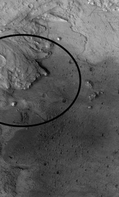
Jezero landing ellipse

This image shows a portion of the landing ellipse (circled) for NASA’s Mars 2020 Perseverance rover, which is expected to land within Jezero crater on 18 February 2021. The complete landing ellipse is 7.7 x 6.6 km, and is centered on an ancient river delta near the rim of Jezero that could hold clues about whether or not Mars was able to harbour life at some point during its ancient past. Jezero crater itself was once the site of a lake, and Perseverance will explore this region looking for signs of fossilized microbial life. 

ESA-Roscosmos ExoMars Trace Gas Orbiter (TGO)

The image was taken by the CaSSIS camera on the ESA-Roscosmos Exomars Trace Gas Orbiter as part of an imaging campaign of the rover's future neighbourhood.

Jezero crater flyover

NASA’s Perseverance rover is expected to arrive at Jezero impact crater, the site of a former lake on Mars, on 18 February 2021. The High Resolution Stereo Camera on ESA’s Mars Express has provided important context for the landing site and its surrounds. A taste of this imagery is provided in this short video clip.

Jezero Crater neighbourhood – 3D

A portion of a crater (left) and rough terrain outside the crater at the boundary between the Syrtis and Isidis regions of Mars, south of the landing site foreseen for NASA’s Mars 2020 rover in Jezero Crater. Use red-blue stereo ‘3D’ glasses to best enjoy this view. It was created from a stereo pair taken by the Colour and Stereo Surface Imaging System (CaSSIS) onboard the ESA-Roscosmos ExoMars Trace Gas Orbiter on 29 December 2018. The image is centred at 20.73ºN/79.27ºE and measures about 7 km on the short side.

Jezero crater and surrounds

Jezero crater, the touchdown site for NASA’s Mars 2020 Perseverance rover, in context of its surroundings. It is situated between highlands, an impact basin, a volcanic province and an ancient river delta. The dark bluish-black areas are layers of ancient volcanic ash that is widely dispersed by the wind, often piling up into impressive dune fields. This image was created from the red, green and blue channels of the High Resolution Stereo Camera on ESA’s Mars Express, combined with high-resolution data from its nadir channel, which is directed perpendicular to the surface of Mars. The high resolution of the data processed for this image allows for greater enlargement, enabling a closer look at individual details of the landscape. Small gaps in the image mosaic were interpolated.

Jezero crater and surrounds (annotated)

Jezero crater, the touchdown site for NASA’s Mars 2020 Perseverance rover, in context of its surroundings. It is situated between highlands, an impact basin, a volcanic province and an ancient river delta. The dark bluish-black areas are layers of ancient volcanic ash that is widely dispersed by the wind, often piling up into impressive dune fields. This image was created from the red, green and blue channels of the High Resolution Stereo Camera on ESA’s Mars Express, combined with high-resolution data from its nadir channel, which is directed perpendicular to the surface of Mars. The high resolution of the data processed for this image allows for greater enlargement, enabling a closer look at individual details of the landscape. Small gaps in the image mosaic were interpolated.

Flight over the Mars 2020 Perseverance rover landing site

This video shows Jezero crater, the landing site of the NASA Mars 2020 Perseverance rover on the Red Planet, based on images from ESA’s Mars Express mission. The planned landing area is marked with an orange ellipse.
Scheduled for launch from Cape Canaveral, Florida on 30 July 2020 on board an Atlas V rocket, the Perseverance rover will land on 18 February 2021 in Jezero crater. An impact crater with a diameter of about 45 km, Jezero is located at the rim of the giant Isidis impact basin. Morphological evidence suggests that the crater once hosted a lake, some 3.5 billion years ago.

Jezero possesses an inlet- and an outlet channel. The inlet channel discharges into a fan-delta deposit, containing water-rich minerals such as smectite clays. Scientists believe that the lake was relatively long lived because the delta may have required 1 to 10 million years to reach its thickness and size. Other studies conclude that the lake did not experience periods of important water-level fluctuations and that it was formed by a continuous surface runoff. This makes Jezero crater to a prime target for the search for potential signs of microbial life, because organic molecules are very well preserved in river deltas and lake sediments.

A recent study of the ancient lakeshores, diverse minerals and violent volcanism of Jezero crater based on data from ESA’s Mars Express mission is available here: Mars Express helps uncover the secrets of Perseverance landing site.

 Mars Express

The animation was created using an image mosaic made from four single orbit observations obtained by the High Resolution Stereo Camera (HRSC) on Mars Express between 2004 and 2008. The mosaic combines data from the HRSC nadir and colour channels; the nadir channel is aligned perpendicular to the surface of Mars, as if looking straight down at the surface. The mosaic image was then combined with topography information from the stereo channels of HRSC to generate a three-dimensional landscape, which was then recorded from different perspectives, as with a movie camera, to render the flight shown in the video.

Topographic map of Jezero crater and surrounds (annotated)

This elevation map of Jezero crater and its surrounds shows the topography of the broader region, from the highlands (red and browns) to the lower lying floor of the Isidis impact basin (green).  The height difference in this area of 1.5 million square kilometres is over 6800 metres, with the floor of Jezero crater lying at an elevation of approximately minus 2600 metres below the ‘Mars Areoid’, a notional plane of equal gravitational attraction, analogous to sea level on Earth.

Jezero crater, the landing site of NASA’s 2020 Perseverance rover mission, is marked on the map. It hosts two river deltas from inflow channels that once brought water into Jezero, which is thought to have once hosted a lake.

This elevation map was created from ESA Mars Express data. The High Resolution Stereo Camera’s nine sensors, arranged at right angles to the north-south flight direction, record the surface of Mars from different angles and in four colour channels. From the four inclined stereo channels and the nadir channel, which is directed perpendicular to the surface of Mars, scientists at the DLR Institute of Planetary Research and the Freie Universität Berlin compute digital terrain models, which assign elevation information to each pixel. The high resolution of the data processed for this image allows for greater enlargement of the images for a closer look at individual details of the landscape.

Topographic map of Jezero crater and surrounds

This elevation map of Jezero crater (inset) and its surrounds shows the topography of the broader region, from the highlands (red and browns) to the lower lying floor of the Isidis impact basin (green).  The height difference in this area of 1.5 million square kilometres is over 6800 metres, with the floor of Jezero crater lying at an elevation of approximately minus 2600 metres below the ‘Mars Areoid’, a notional plane of equal gravitational attraction, analogous to sea level on Earth.

Jezero crater, the landing site of NASA’s 2020 Perseverance rover mission, is close to the centre of this image. Click here for an annotated version. It lies close to two river deltas from inflow channels that once brought water into Jezero, which is thought to have once hosted a lake.

This elevation map was created from Mars Express data. The High Resolution Stereo Camera’s nine sensors, arranged at right angles to the north-south flight direction, record the surface of Mars from different angles and in four colour channels. From the four inclined stereo channels and the nadir channel, which is directed perpendicular to the surface of Mars, scientists at the DLR Institute of Planetary Research and the Freie Universität Berlin compute digital terrain models, which assign elevation information to each pixel. The high resolution of the data processed for this image allows for greater enlargement of the images for a closer look at individual details of the landscape.

The Mars Webcam images NASA rover's landing region

NASA’s Mars 2020 Perseverance rover is due to land on the Red Planet at 21:43 CET on 18 February 2021. Various instruments on ESA's Mars Express spacecraft are supporting the landing by monitoring conditions on Mars in the weeks before. The spacecraft’s Visual Monitoring Camera – also known as the ‘Mars Webcam’ – is providing additional wide context views of the landing region like this one acquired on 1 February 2021, with the region including the landing site, Jezero Crater, circled in yellow.

New topographic map of Jezero Crater – Mars 2020’s future home

On 18 February 2021, NASA’s Mars 2020 spacecraft will touch down on the surface of Mars. The mission, which launched in July of this year and is carrying a rover named Perseverance on board, will seek signs of ancient life on the Red Planet, and collect samples of rock and soil so that these can later be returned to Earth by ESA and NASA.

Mars 2020 will land in Jezero crater, the intriguing feature shown in this new topographic map from ESA’s Mars Express. The landing zone for the mission is highlighted by the black ellipse. This map was created using observations from Mars Express’ High Resolution Stereo Camera (HRSC), and shows the topography of the landscape (as indicated by the coloured bar to the right of the frame, and the associated elevation graph to the bottom). Regions of higher elevation are shown in reds and oranges, while lower dips and depressions are highlighted in blues and greens.

Jezero is an impact crater of roughly 45 kilometres in diameter, and is thought to have once hosted an ancient lake. Evidence of this can be seen in the features scattered across the crater basin: deltas, inlet valleys (marked by solid black lines that wind into the crater to the upper left), channels, and a smoother topography along the northern crater rim (where material was swept up by flowing water) than the southern (where these materials were later deposited). Jezero also hosts a large outlet channel, as seen to the right of the frame (east) in shades of pale blue, and marked by a solid black line. In order to carve such a substantial valley, the crater must have once been replenished by a relatively constant supply of water. This is an exciting prospect in our hunt for life on Mars, as the carbonates and clay minerals thought to still be present in Jezero – which formed in the presence of ancient water – may have locked up signatures of past life.

Mars 2020 will explore the history and chemistry of Jezero to characterise such ancient lakeshore environments in detail – an essential step towards better understanding what early Mars was really like. One of Mars 2020’s key objectives is to collect samples for future return to Earth. This endeavour will require cooperative robotic missions from both NASA and ESA. Current plans for ESA-NASA Mars Sample Return rely on ESA’s small Sample Fetch Rover collecting the samples cached by Mars 2020’s Perseverance rover, before these are launched into Mars orbit by NASA. A further ESA mission, the Earth Return Orbiter, will then swoop in to collect the basketball-sized container of rock and soil samples and return these safely to Earth.

This map comprises observations gathered during Mars Express orbits 5252 and 5270, and covers an area of the martian surface located at approximately 18° N, 77° E.

The ancient lakeshore of Jezero crater on Mars

An elevation map of Jezero Crater on Mars, the landing site for NASA's 2020 Mars Perseverance rover. Lighter colours represent higher elevation. Two recent studies based on ESA's Mars Express observations of Jezero crater have shed light on how and when this intriguing area formed – and identified the regions most likely to reveal signs of ancient life.

The crater rim stands out clearly in this colour map, making it easier to spot the shoreline of a lake that dried up billions of years ago. The oval indicates the landing ellipse, where the rover will be touching down on Mars. Scientists are interested in studying this shoreline because it may have preserved fossilised microbial life, if any ever formed on the Red Planet.

This image was created using data from a combination of instruments and spacecraft: NASA's Mars Global Surveyor and its Mars Orbiter Laser Altimeter (MOLA); NASA's Mars Reconnaissance Orbiter and its Compact Reconnaissance Imaging Spectrometer for Mars (CRISM) and Context Camera (CTX); and the High Resolution Stereo Camera (HRSC) on ESA's Mars Express. It was originally published in November 2019.

Related articles:

NASA’s Next Mars Rover Is Ready for the Most Precise Landing Yet
https://orbiterchspacenews.blogspot.com/2021/02/nasas-next-mars-rover-is-ready-for-most.html

Mars Perseverance landing - In the Jezero neighbourhood
https://orbiterchspacenews.blogspot.com/2021/02/mars-perseverance-landing-in-jezero.html

Related links:

ESA & ROSCOSMOS ExoMars: https://www.esa.int/Science_Exploration/Human_and_Robotic_Exploration/Exploration/ExoMars

ESA Mars Express: https://www.esa.int/Science_Exploration/Space_Science/Mars_Express

NASA Mars Perseverance rover: https://nasa.gov/perseverance

Images, Videos, Text, Credits: ESA/Roscosmos/CaSSIS, CC BY-SA 3.0 IGO/ESA/DLR/FU Berlin, CC BY-SA 3.0 IGO/Animation: ESA/DLR/FU Berlin, CC BY-SA 3.0 IGO ; Music: Björn Schreiner; Soundtrack logo: Alicia Neesemann/NASA/JPL-Caltech/MSSS/JHU-APL/ESA.

Greetings, Orbiter.ch

The Mars Relay Network Connects Us to NASA’s Martian Explorers


NASA - Space Communications and Navigation (SCaN) patch.


Feb. 17, 2021

A tightly choreographed dance between NASA’s Deep Space Network and Mars orbiters will keep the agency’s Perseverance in touch with Earth during landing and beyond.


Image above: Five spacecraft currently in orbit about the Red Planet make up the Mars Relay Network to transmit commands from Earth to surface missions and receive science data back from them. Clockwise from top left: NASA’s Mars Reconnaissance Orbiter (MRO), Mars Atmospheric and Volatile EvolutioN (MAVEN), Mars Odyssey, and the European Space Agency’s (ESA’s) Mars Express and Trace Gas Orbiter (TGO). Image Credits: NASA/JPL-Caltech, ESA.

When NASA’s Mars 2020 Perseverance rover touches down with the Ingenuity Mars Helicopter on the Red Planet on Feb. 18, they won’t be alone. From orbit, two robotic buddies will be playing a special role in the event by checking in on the mission’s vital signs from the moment Perseverance enters the atmosphere to long after it makes its first tracks on the Martian surface.

NASA’s Mars Reconnaissance Orbiter (MRO) and the Mars Atmospheric and Volatile EvolutioN (MAVEN) orbiter are a part of the Mars Relay Network, a constellation of spacecraft that serves as a lifeline to the current surface missions on Mars – NASA’s Curiosity rover and InSight lander.

While some commands and telemetry can be sent directly to and from Earth, for the most part, the huge quantities of science data collected by rovers and landers cannot, because it would take too long. Most data traveling back to Earth must first be sent to the Mars orbiters overhead, which then transmit the data tens of millions of miles through interplanetary space to radio antennas on Earth, including the antennas of NASA’s venerable Deep Space Network (DSN).

“It is a huge endeavor to maintain communications with our spacecraft throughout the solar system, but Mars surface missions take this commitment to another level,” said Bradford Arnold, DSN project manager at NASA’s Jet Propulsion Laboratory in Southern California. “Since Mars Global Surveyor (MGS) arrived in orbit in 1997, a steady stream of orbiters has been added, carrying relay radios and antennas, which provide highly efficient communications between surface landers and Earth. While the choreography of this relay scheme is now somewhat commonplace for assets in place, it is still extremely challenging to coordinate all the communication links for the very brief time during a lander’s arrival.”

This dance will ensure that the world can watch Perseverance’s entry, descent, and landing – a harrowing sequence of events that will begin as the rover’s interplanetary cruise ends.


Image above: The Deep Space Network has ground stations in Madrid (Spain), Goldstone (Southern California), and Canberra (Australia). Pictured here, Madrid’s radio antennas will take the lead in receiving telemetry from the Mars Relay Network during Perseverance’s entry, descent and landing. Image Credits: NASA/JPL-Caltech.

Over the Horizon

As Perseverance enters the Martian atmosphere inside its protective aeroshell, the rover will switch between several of its onboard antennas to stay in contact with Earth. Some of these antennas use powerful X-band transmissions that can send small amounts of data directly to the DSN. Others use ultra high frequencies (or UHF) to communicate with MRO and MAVEN.

Managed by JPL for NASA’s Space Communications and Navigation program (SCaN), the DSN consists of several parabolic radio antennas at ground stations in Southern California, near Madrid, Spain, and outside Canberra, Australia. This configuration allows mission controllers to communicate with spacecraft throughout the solar system at all times throughout Earth’s daily rotation. During Perseverance’s landing, Madrid’s antennas will be trained on Mars, taking the lead when receiving data. The Goldstone complex near Barstow, California, will also be listening in as a backup.

Since the landing of NASA’s Mars Exploration Rovers Spirit and Opportunity in 2004, science data has been routinely relayed via the Mars orbiters to the DSN, beginning with MGS and then NASA’s veteran Odyssey orbiter, which has been circling Mars since 2001.

Because the final two minutes of Perseverance’s descent and landing will be mostly beyond Mars’ horizon from Earth’s perspective, “direct-to-Earth” X-band communications will be impossible, and the rover will communicate with Earth solely via MRO and MAVEN when it lands.

In orbit since 2006, MRO was designed as a science mission and to act as a communications relay for landed surface missions. But it received an upgrade to prepare for Perseverance’s landing.

“In the past year, the software of the MRO spacecraft and its UHF radio have been updated to allow the near-immediate return of data collected during EDL. MRO will capture the telemetry transmitted by Perseverance and use its 3-meter [10-foot] dish to transmit it immediately to Earth,” said Roy Gladden, manager of the Mars Relay Network at JPL. “We call this a ‘bent pipe’, which allows us to get word from Perseverance even though Mars is blocking our view from Earth.”

First Word From Jezero

As MRO relays Perseverance’s landing in near-real-time, engineers in mission control hope to confirm landing – and receive the first image – soon after 12:55 p.m. PST (3:55 p.m. EST). Because of the distance the signal has to travel from Mars to Earth, the spacecraft will have landed (known as “spacecraft event time”) 11 minutes and 22 seconds earlier.

Later, at about 4:27 p.m. PST (7:27 p.m. EST), Odyssey will fly over the landing site and communicate with the rover to confirm its health. The next relay session after that will be at about 6:36 p.m. PST (9:36 p.m. EST) by ESA’s (the European Space Agency’s) Trace Gas Orbiter (TGO), which will also check in on Perseverance’s health and relay any images the rover has transmitted from the landing site.

In addition, MAVEN will capture the entire landing with a data-rich broad spectrum recording, and will send the information back to Earth several hours after landing. This data could be used to fill in any telemetry (engineering data) from the rover during EDL that was missed by MRO during the initial relay, and provide other measurements of the event.

This buddy system helps ensure that little data is lost during Perseverance’s historic landing in Jezero Crater while also confirming the health of the rover and its precise location.

Science Operations

Of course, communications don’t stop after landing. That’s when the complicated task of sending commands to Perseverance and receiving the rover’s huge science data output will begin.

During its mission, the rover will have all of the orbiters in the Mars Relay Network for support – including NASA’s MRO, MAVEN, Odyssey, and ESA’s TGO, which has been playing a key role in the network for the past few years. Even ESA’s Mars Express orbiter will be available for emergency communications should the need arise. While the NASA orbiters communicate exclusively with the DSN, the ESA orbiters also communicate via the European Space Tracking network and ground stations located in Russia.

Although the Mars Relay Network has expanded to include more spacecraft and more international partners, with every new surface mission comes added complexity when scheduling the relay sessions for each orbiter flyover.

“Curiosity and InSight are near enough to each other on Mars that they are almost always visible by the orbiters at the same time when they fly over. Perseverance will land far enough away that it can’t simultaneously be seen by MRO, TGO, and Odyssey, but sometimes MAVEN, which has a larger orbit, will be able to see all three vehicles at the same time,” added Gladden. “Since we use the same set of frequencies when communicating with all three of them, we have to carefully schedule when each orbiter talks to each lander. We’ve gotten good at this over the last 18 years as rovers and landers have come and gone, including collaborating with ESA, and we’re excited to see the Mars Relay Network set new throughput records as it returns Perseverance’s huge data sets.”

Ultimately, this communications endeavor connecting Earth and Mars will enable us to see high-resolution images (and hear the first sounds) captured by Perseverance, and scientists will be able to further our knowledge about the Red Planet’s ancient geology and fascinating astrobiological potential.

More About Perseverance

A key objective of Perseverance’s mission on Mars is astrobiology, including the search for signs of ancient microbial life. The rover will characterize the planet’s geology and past climate, pave the way for human exploration of the Red Planet, and be the first mission to collect and cache Martian rock and regolith.

Subsequent missions, currently under consideration by NASA in cooperation with ESA, would send spacecraft to Mars to collect these sealed samples from the surface and return them to Earth for in-depth analysis.

The Mars 2020 mission is part of a larger NASA initiative that includes missions to the Moon as a way to prepare for human exploration of the Red Planet. Charged with returning astronauts to the Moon by 2024, NASA will establish a sustained human presence on and around the Moon by 2028 through NASA’s Artemis lunar exploration plans.

JPL, which is managed for NASA by Caltech in Pasadena, California, built and manages operations of the Perseverance rover.

For more about Perseverance:

https://mars.nasa.gov/mars2020/

https://nasa.gov/perseverance

For more information about NASA's Mars missions:

https://www.nasa.gov/mars

More About DSN

The Deep Space Network is managed by JPL for NASA’s Space Communications and Navigation (SCaN), which is located at NASA’s headquarters within the Human Exploration and Operations Mission Directorate.

More About the Mars Relay Network

The Mars Relay Network is part of the Mars Exploration Program, which is managed at JPL on behalf of NASA’s Planetary Science Division within its Science Mission Directorate.

Related articles:

NASA’s Next Mars Rover Is Ready for the Most Precise Landing Yet
https://orbiterchspacenews.blogspot.com/2021/02/nasas-next-mars-rover-is-ready-for-most.html

Mars Perseverance landing - In the Jezero neighbourhood
https://orbiterchspacenews.blogspot.com/2021/02/mars-perseverance-landing-in-jezero.html

Related links:

Mars Reconnaissance Orbiter (MRO): https://mars.nasa.gov/mro/

Mars Atmospheric and Volatile EvolutioN (MAVEN): https://mars.nasa.gov/maven/

Curiosity rover (MSL): https://mars.nasa.gov/msl/home/

InSight lander: https://mars.nasa.gov/insight/

Mars Global Surveyor (MGS): https://www.jpl.nasa.gov/missions/mars-global-surveyor

Odyssey orbiter: https://mars.nasa.gov/odyssey/

ESA & ROSCOSMOS ExoMars: https://www.esa.int/Science_Exploration/Human_and_Robotic_Exploration/Exploration/ExoMars

ESA Mars Express: https://www.esa.int/Science_Exploration/Space_Science/Mars_Express

Deep Space Network (DSN): https://eyes.nasa.gov/dsn/dsn.html

NASA’s Space Communications and Navigation (SCaN): https://www.nasa.gov/directorates/heo/scan/index.html

Mars Relay Network: https://eyes.jpl.nasa.gov/mrn

Artemis lunar exploration plans: https://www.nasa.gov/specials/artemis/

Images (mentioned), Text, Credits: NASA/Grey Hautaluoma/Alana Johnson/JPL/Ian J. O'Neill.

Greetings, Orbiter.ch