NOAA / NASA - GOES Mission logo.
Dec. 9, 2015
An animation of satellite imagery over the course of 10 days shows a series of low pressure areas pummeling the Pacific Northwest. The video, created by the NASA/NOAA GOES Project at NASA's Goddard Space Flight Center in Greenbelt, Maryland combined visible and infrared imagery from NOAA's GOES-West satellite.
GOES-15 Video of Storms Buffeting the Pacific Northwest
Video above: This animation of imagery from NOAA's GOES-15 shows a series of storms buffeting the Pacific Northwestern U.S. from Nov. 29 to early Dec. 9. Video Credits: NASA/NOAA GOES Project.
The animation shows a series of storms buffeting the Pacific Northwestern U.S. from Nov. 29 to Dec. 9, 2015.
The National Weather Service Weather Prediction Center (NWS NPC) in College Park, Maryland called it "a classic atmospheric river event" that was on-going across the pacific northwest with subtropical moisture streaming Into the region combined with a series of upper level disturbances.
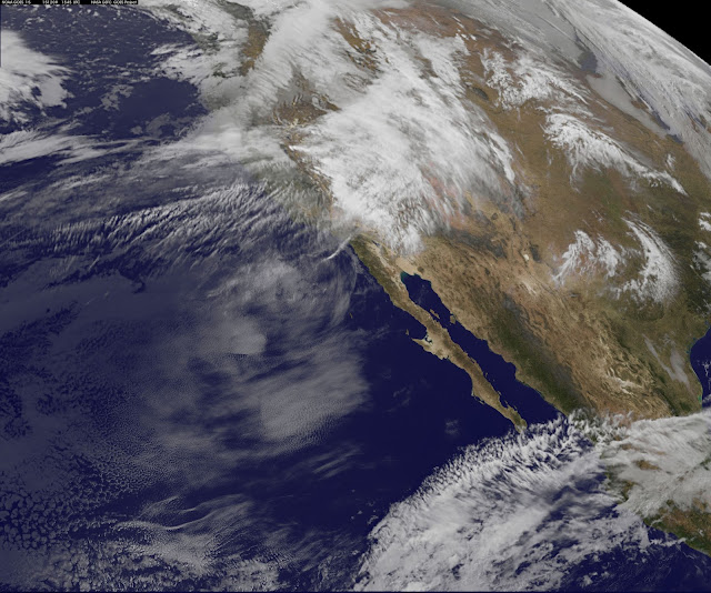
On Dec. 9, National Weather Service doppler radars and surface observations showed moderate to heavy rain falling in western Washington and northwestern Oregon. Light to moderate rain, along with snow in higher elevations was also falling across portions of the northern inter-mountain west and northern Rockies.
Image above: This image from NOAA's GOES-15 on Dec. 9 at 1545 UTC (10:45 a.m. EST) shows the latest in a series of storms that have been affecting the Pacific Northwestern U.S. Image Credits: NASA/NOAA GOES Project.
On Dec. 9, there were a lot of watches and warnings in the region. Flood watches, warnings and flood advisories were in effect for portions of the Pacific Northwest as well as parts of northern California and northern Idaho. Winter storm watches and warnings were in effect for the Sierra Nevada Range in California and parts of the intermountain west. High wind watches, warnings and wind advisories were in effect for portions of the northwest U.S., especially in the higher terrain.
NWS Portland said that the active weather pattern will likely continue through Tuesday, Dec. 15, as a series of systems push across the Pacific Northwest. Models continue to bring more rain and cascade snow to the region this weekend.
Related links:
GOES (Geostationary Environmental Operational Satellites): http://www.nasa.gov/goes/
Goddard Space Flight Center: http://www.nasa.gov/centers/goddard/home/index.html
Image (mentioned), Video (mentioned), Text, Credits: NASA's Goddard Space Flight Center/Rob Gutro/Lynn Jenner.
Greetings, Orbiter.ch


