NOAA & NASA - Suomi NPP Mission patch / NASA - EOS Aqua Mission logo.
Sept. 8, 2019
Dorian – Atlantic Ocean
NASA satellites provided forecasters at the National Hurricane Center with infrared data and cloud top temperature information for Hurricane Dorian. Infrared data revealed that Dorian was becoming an extra-tropical cyclone as it moved northeast along the U.S. east coast and the area of strong storms had diminished around the storm.
Suomi NPP satellite. Image Credits: NOAA/NASA
NASA researches tropical cyclones and infrared data is one of the ways NASA uses. Cloud top temperatures provide information to forecasters about where the strongest storms are located within a tropical cyclone. The stronger the storms, the higher they extend into the troposphere, and they have the colder cloud temperatures.
On Sept. 6, at 2:23 p.m. EDT (1823 UTC), NASA’s Aqua satellite analyzed the storm using the Atmospheric Infrared Sounder or AIRS instrument. AIRS found coldest cloud top temperatures as cold as or colder than minus 80 degrees Fahrenheit (minus 62.2 degrees Celsius) circling around the center (eye) and in a thick band of thunderstorms northeast of the center. NASA research has shown that cloud top temperatures that cold indicate strong storms that have the capability to create heavy rain.
Image above: On Sept. 6, at 2:23 p.m. EDT (1823 UTC) the AIRS instrument aboard NASA’s Aqua satellite analyzed cloud top temperatures of Hurricane Dorian in infrared light. AIRS found coldest cloud top temperatures (purple) of strongest thunderstorms were as cold as or colder than minus 80 degrees Fahrenheit (minus 62.2 degrees Celsius) around the center and in a thick band of thunderstorms northeast of the center. Image Credits: NASA JPL/Heidar Thrastarson.
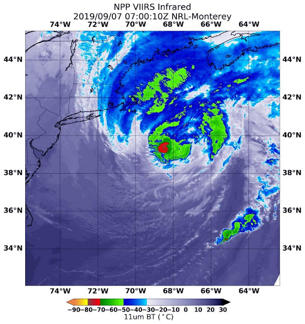
On Sept. 7 at 3 a.m. EDT (0700 UTC), it was NASA-NOAA’s Suomi NPP satellite that provided an infrared view of Hurricane Dorian as it was transitioning into an extra-tropical storm. Strongest storms had cloud top temperatures as cold as or colder than minus 80 degrees Fahrenheit (minus 62.2 degrees Celsius) where the heaviest rain was falling over the open waters of the Atlantic Ocean. Those storms were now limited to the southern side of the storm, unlike the previous day, when they circled the eye.
Image above: NASA-NOAA’s Suomi NPP satellite provided an infrared view of Hurricane Dorian as it was transitioning into an extra-tropical storm on Sept. 7 at 3 a.m. EDT (0700 UTC). Strongest storms (red) had cloud top temperatures as cold as or colder than minus 80 degrees Fahrenheit (minus 62.2 degrees Celsius) where the heaviest rain was falling over the open waters of the Atlantic Ocean. Image Credits: NASA/NOAA/NRL.
NOAA’s National Hurricane Center’s (NHC) discussion said “Satellite imagery this morning [Sept. 7] indicates that Dorian is starting extratropical transition, with cold air clouds entraining [moving] into the southwestern side of the cyclone and a developing warm front to the north and east.”
EOS Aqua satellite. Image Credit: NASA
What is an Extra-Tropical Cyclone?
When a storm transitions into an extra-tropical cyclone, it means that a tropical cyclone has lost its tropical characteristics. The National Hurricane Center defines “extra-tropical” as a transition that implies both poleward displacement (meaning it moves toward the north or south pole) and the conversion of the cyclone’s primary energy source from the release of latent heat of condensation to baroclinic (the temperature contrast between warm and cold air masses) processes. It is important to note that cyclones can become extratropical and still retain winds of hurricane or tropical storm force.
Warnings and Watches in Effect on Sept. 7
NOAA’s National Hurricane Center’s (NHC) continued to issue warnings and watches as Dorian makes its way toward Canada today. A Hurricane Warning is in effect for eastern Nova Scotia from lower east Pubnico to Brule, and for western Newfoundland from Indian Harbour to Hawke’s Bay, Canada. A Hurricane Watch is in effect for Prince Edward Island and the Magdalen Islands.
A Tropical Storm Warning is in effect from east of Bar Harbor to Eastport, ME, and for Prince Edward Island, Canada. It is also in effect for southwestern Nova Scotia from Avonport to north of Lower East Pubnico, Fundy National Park to Shediac, Stone’s Cove to Indian Harbour, Hawke’s Bay to Fogo Island and from Mutton Bay to Mary’s Harbour, Canada.
Status of Hurricane Dorian on Saturday, September 7, 2019
On Saturday, September 7, 2019 at 11 a.m. EDT (1500 UTC), the center of Hurricane Dorian was located near latitude 42.0 degrees north and longitude 66.0 degrees west.
Dorian’s center is about 205 miles (330 km) south-southeast of Eastport, Maine and about 215 miles (350 km) southwest of Halifax, Nova Scotia, Canada.
The NHC said Dorian is moving toward the northeast near 29 mph (46 kph), and a general motion toward the northeast is expected to continue through Sunday night. Maximum sustained winds are near 85 mph (140 kph) with higher gusts. Dorian is expected to become a hurricane-force post-tropical cyclone as it moves across eastern Canada tonight or on Sunday, Sept. 8. The estimated minimum central pressure is 953 millibars.
What’s Next for Dorian?
Dorian is expected to finish transition into an extratropical cyclone over the next day as it merges with a strong mid- to upper-level trough (elongated area of low pressure) and its associated surface front.
On the NHC forecast track, the center of Dorian is expected to move across central or eastern Nova Scotia this afternoon or this evening, pass near or over Prince Edward Island tonight, and then move near or over portions of Newfoundland and Labrador on Sunday.
For updated forecasts, visit: http://www.nhc.noaa.gov/
NASA-NOAA’s Suomi NPP satellite: http://www.nasa.gov/mission_pages/NPP/main/index.html
NASA’s Aqua satellite: https://www.nasa.gov/mission_pages/aqua/index.html
Images (mentioned), Text, Credits: NASA’s Goddard Space Flight Center, by Rob Gutro.
Greetings, Orbiter.ch


