
Natural Disasters logo.
Aug. 18, 2022
More must be done to forecast and try to manage globally disruptive volcanic eruptions. The risks are greater than people think.
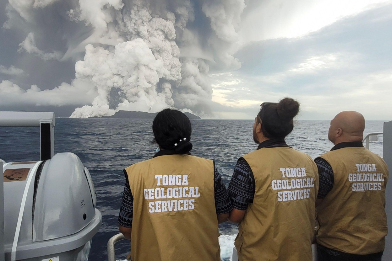
Image above: Tonga Geological Services staff making observations of the Hunga Tonga–Hunga Ha‘apai volcano. Image Credits: Tonga Geological Services/ZUMA/Alamy.
The massive eruption of the Hunga Tonga–Hunga Ha‘apai volcano this January in Tonga, in the south Pacific Ocean, was the volcanic equivalent of a ‘near miss’ asteroid whizzing by the Earth. The eruption was the largest since Mount Pinatubo in the Philippines blew in 1991, and the biggest explosion ever recorded by instruments.
Ash fell over hundreds of kilometres, affecting infrastructure, agriculture and fish stocks. The damage caused amounted to 18.5% of Tonga’s gross domestic product. Submarine cables were severed, cutting off Tonga’s communications with the outside world for several days; farther afield, the blast created a worldwide shockwave and tsunamis that reached Japanese and North and South American coastlines. Mercifully, the eruption lasted only about 11 hours. Had it gone on for longer, released more ash and gas or occurred in more densely populated areas of southeast Asia, or near a high concentration of vital shipping lanes, electricity grids or other crucial global infrastructure, it would have had repercussions for supply chains, climate and food resources worldwide (1).
The world is woefully unprepared for such an event. The Tongan eruption should be a wake-up call. Recent data from ice cores suggest that the probability of an eruption with a magnitude of 7 (10 or 100 times larger than Tonga) or greater this century is 1 in 6 (2). Eruptions of this size have, in the past, caused abrupt climate change and the collapse of civilizations, and have been associated with the rise of pandemics (3).
And yet, little investment has gone into limiting what an eruption of this magnitude could do. Impacts would cascade across transport, food, water, trade, energy, finance, and communication in our globally connected world.
Over the next century, large-scale volcanic eruptions are hundreds of times more likely to occur than are asteroid and comet impacts, put together (4). The climatic impact of these events is comparable, yet the response is vastly different. ‘Planetary defence’ receives hundreds of millions of dollars in funding each year, and has several global agencies devoted to it. In September, NASA’s Double Asteroid Redirection Test (DART) mission will try to nudge an asteroid’s trajectory, testing capabilities for future asteroid deflection. That advance-preparation project will cost over US$300 million. By contrast, there is no coordinated action, nor large-scale investment, to mitigate the global effects of large-magnitude eruptions. This needs to change.
Deep impact
Although researchers have long known of the drastic impacts of large-scale volcanic eruptions, the likelihood of such an event has only recently been clarified.
The recurrence rate of large eruptions can be determined by searching the long-term records for sulfate spikes, stemming from the gas released during globally significant events. In 2021, researchers looked at ice cores from both poles and identified 1,113 signatures of eruptions in the Greenland ice and 737 in Antarctica, occurring between 60,000 and 9,000 years ago. They found 97 events that probably had a climatic impact equivalent to that of a magnitude 7 eruption or greater. They concluded that magnitude-7 events happen about once every 625 years, and magnitude-8 events (also called super-eruptions) about once every 14,300 years2. That’s more frequent than suggested by previous assessments — using geological records and statistical techniques — that found recurrence intervals of 1,200 years for magnitude 7 and 17,000 years for magnitude 8 (5).

Image above: Mount Rinjani in Indonesia was the site of a magnitude-7 eruption in 1257. Image Credit: Michael Cassidy.
The last magnitude-7 event was in Tambora, Indonesia, in 1815. In the archipelago, an estimated 100,000 people died as a result of volcanic flows, tsunamis, the deposition of heavy rocks and ash on crops and houses, and subsequent effects. Globally, temperatures dropped about 1 °C on average, causing the ‘year without a summer’. The eastern United States and much of Europe endured mass crop failures, and the resulting famines led to violent uprisings and disease epidemics.
The world is very different now. In some ways, it is more resilient: volcanoes are better monitored, there is better education and awareness, and health-care and food systems have improved. In other ways, the risks to humanity are increasing. Thanks to changes in ocean and atmospheric circulation caused by climate change, a large-magnitude eruption in the tropics could cause 60% more cooling in the next century compared with today (6). The frequency of eruptions could also increase as geophysical forces on the planet’s surface shift because of ice melt, changes in precipitation and sea-level rise (7).
Although the cooling effects of sulfate aerosols in the stratosphere might counteract warming from greenhouse gases (the world is already around 1.1 °C warmer than in the pre-industrial era), the impact of a large volcanic eruption would be abrupt and immense, with uneven effects on weather, rainfall and temperature.
The global population is eight times larger now than in 1800, and the trade it relies on has grown more than 1,000-fold since then. As the COVID-19 pandemic and the war in Ukraine have shown, the modern world is highly dependent on global trade for food, fuel and resources; a disaster in one spot can cause price spikes and shortages far away.
The financial losses resulting from a large-magnitude eruption are estimated to be in the multi-trillions (8), roughly comparable to those of the pandemic. Given the estimated recurrence rate for a magnitude-7 event, this equates to more than US$1 billion per year. Investing in crisis preparedness and mitigation would be far cheaper than reacting to a disaster. We call for increased attention to, and coordination in, research aimed at forecasting, preparedness and mitigation. Below we suggest what these efforts might look like; for further reading, see the Supplementary Information.
Pinpoint the risks
Of the 97 large-magnitude volcanic eruptions detected in ice-core records, only a handful could be attributed to specific volcanoes. The sites of others remain a mystery, including some that occurred startlingly recently — for example, the eruptions that led to the ‘Late Antique Little Ice Age’ in the mid-sixth century. Estimates show that up to 80% of magnitude-6 eruptions before ad 1 are currently missing from the global geological record (9), with especially poor data for oceanic islands such as the Kuriles, as well as Indonesia and the Philippines, countries with some of the highest densities of volcanoes.
Some 1,300 volcanoes have erupted at some point during the past 10,000 years, meaning they are considered active. But there are probably many other active volcanoes: their recent eruptions might not be known because their locations haven’t been studied, or they may have lain dormant for a long time but still be capable of a large explosive event. Identifying potentially active volcanoes (10) requires a comprehensive approach.
Further research into historical and geological records — including marine and lake cores, especially in neglected regions such as southeast Asia — would help to pinpoint volcanic hazards and map out where large eruptions tend to happen.
Regions of heightened vulnerability and exposure to volcanic threats should also be identified. That will require interdisciplinary research to locate the highest global risks to trade, energy, critical infrastructure, food and water security, and finance (1). There are likely to be pinch points where large volcanic threats overlie dense trade networks, for example the Straits of Malacca — between Peninsular Malaysia and Sumatra in Indonesia — and the Mediterranean Sea.
Improve monitoring
Only 27% or so of the eruptions since 1950 have been monitored with at least one instrument such as a seismometer (11). Data from only about one-third of these eruptions have been collected by the global database for volcanic unrest, WOVOdat. Improved ground-based monitoring of known active volcanoes — including measures of seismicity, gas release and ground deformation — could provide better advance warning of eruptions, especially when combined with emerging analyses that are aided by artificial intelligence.
Where local ground-based monitoring is not feasible, particularly in remote areas, satellite and aerial observation become essential. In addition to monitoring thermal, gas and deformation changes, satellites could provide real-time mass eruption rates, plume heights and imagery for disaster relief. But current satellites lack the necessary resolution in time and space.
Animation above: Satellite imagery of the Hunga Tonga–Hunga Ha‘apai volcano before and after the eruption of 14 January 2022. Animation Credits: Maxar/Getty.
For example, after the Tongan eruption, it was 12 hours before the first radar images, from the European Union’s Sentinel-1A probe, captured changes at the volcano. Often, volcanologists must also rely upon the generosity of private satellite companies to provide real-time high-resolution imagery, as was the case when Capella Space, based in San Francisco, California, provided images one day after the explosive eruption of La Soufrière, in Saint Vincent and the Grenadines, began in April 2021.
A four-year pilot project by the Committee on Earth Observation Satellites (CEOS) showed that existing satellite-radar images of ground deformation could be harnessed to help to track volcano activity in Latin America. CEOS recommended a host of steps to speed up transmission of data to local observatories, improve data interpretation and expand the strategy to other regions (12).
For more than two decades, volcanologists have called for a dedicated volcano-observing satellite to be launched. Much progress has been achieved by sharing satellites, yet a step-change in volcano surveillance could be achieved with a dedicated satellite observing in the infrared (13), or high-altitude drones that acts as pseudo-satellites for months at a time.
Ramp up preparedness
To increase resilience at the community level and to support the humanitarian responses, real-time monitoring and simulations of ash fallout, gas plumes and other hazards, such as volcanic flows, should be fed into real-time, targeted communication. This ‘nowcasting’ advice could be delivered by SMS, instructing someone to ‘clear volcanic ash off your roof to prevent collapse, as 50 centimetres of ash is expected over the next 2 hours’, for example, or directing them to the nearest centres for emergency supplies and health-care.
Increased emphasis on community-focused education and awareness can help to prepare people who live in vulnerable regions. The Volcano Ready Communities Project in Saint Vincent and the Grenadines, run by the University of the West Indies Seismic Research Centre,is a recent success story. It contributed to the effective evacuation of 20,000 people before the 2021 explosive eruptions, with no loss of life. Similar community-awareness programmes should be scaled up around the globe.
Building greater resilience into critical infrastructure such as energy grids and communications networks could lessen regional impacts. Global policy agreements could prioritize transport of important commodities such as oil, gas, fertilizers, food, electronics and crucial metal resources, as well as ensuring that countries do not act in their own narrow interest by, for example, instigating export bans that could exacerbate food shortages. Global bodies such as the United Nations Office for Disaster Risk Reduction have not yet undertaken such focused efforts.
Research volcano geoengineering
Some of the most widespread impacts of large-magnitude eruptions stem from the stratospheric injection of sulfur aerosols that block sunlight and abruptly cool the Earth. Research into how to counteract them could help to curtail a volcanic winter.
Studies have considered the use of sulfates to counteract human-induced warming by deflecting solar radiation. The opposite scenario rarely gets attention. It is theoretically possible to release a short-lived warming agent, such as a hydrofluorocarbon, to counteract the cooling of sulfates (14), or to use a high-altitude aircraft to release non-toxic substances that bind to sulfate aerosols to enhance their removal from the atmosphere, in a manner similar to cirrus-cloud thinning. Such efforts might have significant costs and side effects, such as acid rain, as well as large potential benefits.
Being able to affect volcanic behaviour directly might seem inconceivable, but so did the deflection of asteroids until the formation of NASA’s Planetary Defense Coordination Office in 2016. Numerous examples from geothermal exploration show that it is technically possible to penetrate magmatic bodies in the crust with little collateral damage. In 2024, researchers plan to drill into a magma pocket at the Krafla test bed in Iceland, to provide a ‘long-term magma observatory’ and test sensing equipment to potentially improve volcanic prediction. Research should also be undertaken to assess if it is possible to manipulate the magma or surrounding rocks to moderate eruption explosivity — one such project, Magma Outgassing During Eruptions and Geothermal Exploration, has funding from the European Research Council to 2026.
Whether scientists should conduct any volcano engineering, which has obvious risks, is a matter for debate. But such a debate requires rigorous theoretical and experimental research to underpin it. In our view, the lack of investment, planning and resources to respond to big eruptions is reckless.
Will humanity learn from volcanology’s near miss in Tonga, or will a large-magnitude eruption be the next planet-disrupting event to catch the world unawares after the pandemic? Discussions must start now.
Nature 608, 469-471 (2022)
doi: https://doi.org/10.1038/d41586-022-02177-x
References:
1. Mani, L., Tzachor, A. & Cole, P. Nature Commun. 12, 4756 (2021).
https://doi.org/10.1038%2Fs41467-021-25021-8
2. Lin, J. et al. Clim. Past 18, 485–506 (2021).
https://doi.org/10.5194%2Fcp-18-485-2022
3. Newhall, C., Self, S. & Robock, A. Geosphere 14, 572–603 (2018).
https://doi.org/10.1130%2FGES01513.1
4. Trilling, D. E. et al. Astron. J. 154, 170 (2017).
https://doi.org/10.3847%2F1538-3881%2Faa8036
5. Rougier, J., Sparks, R. S. J., Cashman, K. V. & Brown, S. K. Earth Planet. Sci. Lett. 482, 621–629 (2018). https://doi.org/10.1016%2Fj.epsl.2017.11.015
6. Aubry, T. J. et al. Nature Commun. 12, 4708 (2021).
https://doi.org/10.1038%2Fs41467-021-24943-7
7. Aubry, T. J. et al. Bull. Volcanol. 84, 58 (2022).
https://doi.org/10.1007%2Fs00445-022-01562-8
8. Mahalingam, A. et al. Impacts of Severe Natural Catastrophes on Financial Markets (Cambridge Centre for Risk Studies, 2018). http://scholar.google.com/scholar_lookup?&title=Impacts%20of%20Severe%20Natural%20Catastrophes%20on%20Financial%20Markets&publication_year=2018&author=Mahalingam%2CA.
9. Deligne, N. I., Coles, S. G. & Sparks, R. S. J. J. Geophys. Res. Solid Earth 115, B06203 (2010). https://doi.org/10.1029%2F2009JB006554
10. Giordano, G. & Caricchi, L. Annu. Rev. Earth Planet. Sci. 50, 231–259 (2022).
https://doi.org/10.1146%2Fannurev-earth-032320-084733
11. Costa, F. et al. Disaster Prev. Manag. 28, 738–751 (2019).
https://doi.org/10.1108%2FDPM-09-2019-0301
12. Pritchard, M. E. et al. J. Appl. Volcanol. 7, 5 (2018).
https://doi.org/10.1186%2Fs13617-018-0074-0
13. Ramsey, M. S., Harris, A. J. L. & Watson, I. M. Bull. Volcanol. 84, 6 (2021).
https://doi.org/10.1007%2Fs00445-021-01501-z
14. Fuglestvedt, J. S., Samset, B. H. & Shine, K. P. Geophys. Res. Lett. 41, 8627–8635 (2014). https://doi.org/10.1002%2F2014GL061886
Related articles:
Tonga Eruption Blasted Unprecedented Amount of Water Into Stratosphere
https://orbiterchspacenews.blogspot.com/2022/08/tonga-eruption-blasted-unprecedented.html
Burst of underwater explosions powered Tonga volcano eruption
https://orbiterchspacenews.blogspot.com/2022/06/burst-of-underwater-explosions-powered.html
NASA Mission Finds Tonga Volcanic Eruption Effects Reached Space
https://orbiterchspacenews.blogspot.com/2022/05/nasa-mission-finds-tonga-volcanic.html
Tonga Eruption Sent Ripples Through Earth’s Ionosphere
https://orbiterchspacenews.blogspot.com/2022/02/tonga-eruption-sent-ripples-through.html
Deep down temperature shifts give rise to eruptions
https://orbiterchspacenews.blogspot.com/2022/02/deep-down-temperature-shifts-give-rise.html
Dramatic Changes at Hunga Tonga-Hunga Ha‘apai
https://orbiterchspacenews.blogspot.com/2022/01/dramatic-changes-at-hunga-tonga-hunga.html
How the Tonga eruption is helping space scientists understand Mars
https://orbiterchspacenews.blogspot.com/2022/01/how-tonga-eruption-is-helping-space.html
Hunga Tonga-Hunga Ha‘apai Erupts
https://orbiterchspacenews.blogspot.com/2022/01/hunga-tonga-hunga-haapai-erupts.html
Tonga eruption heard in New Zealand, pressure waves picked up in Europe
https://orbiterchspacenews.blogspot.com/2022/01/tonga-eruption-heard-in-new-zealand.html
Related links:
NASA - Earth: https://www.nasa.gov/topics/earth/index.html
NASA - Hazards: https://www.nasa.gov/subject/3130/hazards
Images (mentioned), Animation (mentioned), Text, Credits: Nature/Michael Cassidy.
Greetings, Orbiter.ch