mardi 3 juillet 2012

A geyser of hot gas flowing from a star


ESA - Hubble Space Telescope logo.

3 July 2012

 Hubble image of Herbig-Haro object HH 110

The NASA/ESA Hubble Space Telescope has captured a new image of Herbig-Haro 110, a geyser of hot gas flowing from a newborn star.

Although Herbig–Haro (HH) objects come in a wide array of shapes, the basic configuration is usually the same. Twin jets of heated gas, ejected in opposite directions from a forming star, stream through interstellar space. These outflows are fueled by gas falling onto the young star, which is surrounded by a disc of dust and gas. If the disc is the fuel tank, the star is the gravitational engine, and the jets are the exhaust.

In Hubble’s image of HH 110, one such turbulent streamer of gas can clearly be seen streaking across the frame.

The intricate structures within HH 110 and other Herbig–Haro objects exist because the jets are not being blown through a pure vacuum. When the energetic and fast-moving Herbig–Haro jets slam into colder gas, they form shock fronts that look and behave much like the bow waves that form in front of a boat. These so-called bow shocks, which glow thanks to very high temperatures, are a distinctive feature of Herbig-Haro objects.

The structure of HH 110 and other objects like it acts like a ticker-tape, recording the activity of the star that is the origin of the jet. Erratic outbursts from the star happen at times when more matter is falling in, and these are recorded as brighter knots or blobs within the Herbig-Haro object, which move along the jet over the years. Although the jets are very fast-moving, they are also very large: the streamer of gas in this image is around half a light-year in length. This means that the motion appears quite slow from our vantage point, even when measured over years (see heic1113).

The NASA / ESA Hubble Space Telescope during Servicing Mission 4

By measuring the current speed and positions of blobs within a Herbig-Haro object, astronomers can rewind time, projecting the motion of the knots backwards to the moment when they were emitted. This in turn tells the scientists about the environment directly around the forming star.

Notes:

The Hubble Space Telescope is a project of international cooperation between ESA and NASA.

Links:

    Images of Hubble: http://www.spacetelescope.org/images/archive/category/spacecraft/

    NASA press release: http://hubblesite.org/news/2012/30

Images, Text, Credit: NASA, ESA and the Hubble Heritage Team (STScI/AURA).

Cheers, Orbiter.ch

SMOS satellite measurements improve as ground radars switch off


ESA - SMOS Mission logo.

3 July 2012

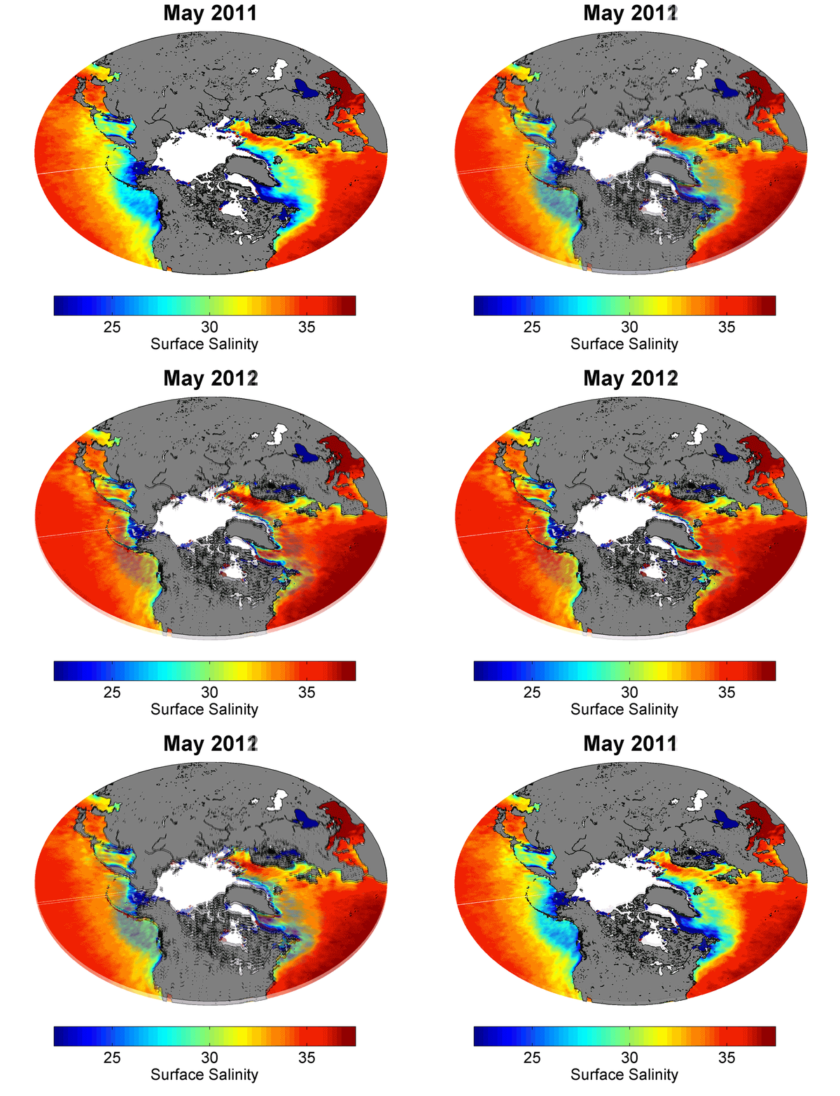
Over a dozen radio signals that have hindered data collection on ESA’s SMOS water mission have been switched off. The effort also benefits satellites such as NASA’s Aquarius mission, which measures ocean salinity at the same frequency.

We all know what happens when you place a cell phone too close to a speaker: seconds before the phone rings, that obnoxious buzz interrupts your favourite song.

Sea surface salinity

This is radio interference – an unwanted reception of radio signals. Not only can it interrupt the music from your stereo, it can also impede satellite measurements.

ESA’s Soil Moisture and Ocean Salinity (SMOS) satellite was launched in 2009 to improve our understanding of our planet’s water cycle. In order to do this, it measures the microwaves emitted by Earth in the 1400–1427 MHz range. 

SMOS immediately revealed that many unlawful signals were being transmitted around the world in this frequency range, rendering some of its measurements unusable for scientific purposes.

Radio interference

Over the years, ESA has investigated exactly where the interference is coming from.

As national authorities have collaborated with ESA to pinpoint the origin and switch these unlawful emissions off, the interference has waned.

One of the largest areas of contamination in the northern hemisphere is over the North Pacific and Atlantic oceans, primarily from military radars.

Over recent years, authorities from Canada and Greenland have been asked to take action. Canada started to refurbish their equipment in late 2011, while Greenland switched off their transmitters in March 2011.

SMOS in orbit

At least 13 sources of interference have now been switched off in the northern latitudes. This has significantly improved SMOS observations at these high latitudes, which were previously so contaminated that accurate salinity measurements were not possible above 45 degrees latitude as the satellite headed north.

However, the few remaining sources can contaminate areas 3000 km away, especially as SMOS climbs north towards North America.

The efforts to reduce interference will benefit other missions carrying similar detectors, such as NASA’s Aquarius satellite, which was launched last year.

Aquarius also observes ocean salinity and, in addition, it measures sea-surface roughness to help understand how roughness affects salinity measurements.

Cleaner SMOS results

A unique feature of SMOS is that it also measures soil moisture. SMOS and Aquarius readings are highly complementary: SMOS repeats coverage faster and at finer detail, while Aquarius has better ‘pixel by pixel’ accuracy.

Scientists are trying to combine both sets of measurements in the best way to improve global salinity maps.

“Combining SMOS and Aquarius new observations will allow us to map ocean surface salinity with an unprecedented spatial and temporal resolution,” said Nicolas Reul from the French Research Institute for Exploration of the Sea.

“In particular, salinity fronts and the movement of water across tropical oceans and within strong currents – such as the Gulf Stream – shall be better detected and tracked than with single-sensor observations.”

Related links:

SMOS: http://www.esa.int/SPECIALS/smos/index.html

Access SMOS data: http://earth.esa.int/SMOS/

SMOS ocean user meeting at EGU 2012: https://earth.esa.int/web/guest/smos-egu-2012

Ifremer–Cersat Salinity Center: http://www.salinityremotesensing.ifremer.fr/home

Images, Animations, Text, Credits: ESA / AOES Medialab / N. Reul, IFREMER / CATDS.

Best regards, Orbiter.ch

Mission accomplished for Galileo's pathfinder GIOVE-A


ESA - Galileo - GIOVE Mission patch.

3 July 2012

With the initial satellites of the Galileo constellation working well in orbit, it has been decided to end the mission of ESA’s pioneering GIOVE-A navigation satellite.

Launched on 28 December 2005, this first experimental satellite performed the vital task of securing the radio frequencies provisionally set aside for Galileo by the International Telecommunications Union.

It also flight-tested Galileo atomic clocks and other equipment in space for the very first time and investigated the radiation environment of medium-altitude orbits, never used before by a European mission. 

Artist's impression of GIOVE-A

ESA formally ended GIOVE-A’s mission at the end of June, although it will go on being operated for now by prime contractor Surrey Satellite Technology Ltd of Guildford, UK, to gather radiation data and performance results from a GPS receiver.

“GIOVE-A had a design life of only 27 months, so to continue operating for 78 months is impressive,” said Valter Alpe, managing GIOVE activities for ESA.

“In August 2009, the satellite was moved into a graveyard orbit around 100 km above its normal 23 222 km to make way for the Galileo validation satellites.

“The first two of these were launched on 21 October 2011 and are performing well, so while GIOVE-A has served ESA well it no longer has a job to do.”

Lift off of Soyuz carrying GIOVE-A

Built to a tight deadline by SSTL, GIOVE-A carries a rubidium atomic clock accurate to three seconds in a million years.

On 27 April 2008 it was joined by GIOVE-B, built by an Astrium-led consortium, which carries an even more accurate passive hydrogen maser clock – the first to be flown in space for navigation, accurate to one second in three million years – as well as a second rubidium clock. Operational Galileo satellites carry two pairs of both kinds of clock, for redundancy.

They are very different missions in other ways too. The GIOVEs were modified from existing satellite platforms: a prototype geostationary minisatellite for GIOVE-A, and a commercial French Proteus platform typically used for Earth observation for GIOVE-B.

GIOVE-A mated with Fregat launcher upper stage

Galileo satellites are based on an entirely new platform and improved payload, specifically engineered for extremely high reliability, only intended to go into safe mode for a few days over their planned 12 years of operation thanks to a robust design based on reconfigurable redundancy.

Even when entering ‘intermediate safe mode’ they can continue to supply navigation signals, although without the usual service guarantee.

GIOVE-B, with an orbital lifetime of 50 months and counting, will be used in payload fine calibration tests this summer with the two Galileo satellites.

Then, in September, it will be manoeuvred into a graveyard orbit 300 km higher. At this point, GIOVE-B’s own mission will end.

GIOVE-B in orbit

“Early October will see the launch of the next two Galileo satellites by Soyuz rocket from Europe’s Spaceport in French Guiana,” added Valter.

“This will be an important step forward because four satellites are the minimum to perform navigation measurements, so Galileo system testing can proceed.” A follow-up batch of full operational capability Galileo satellites is being built by Germany’s OHB and SSTL, with initial Galileo services forecast to be available by 2014.

External links:

European Commission - Galileo: http://ec.europa.eu/enterprise/policies/satnav/galileo/index_en.htm

Surrey Satellite Technolgy Limited: http://www.sstl.co.uk/

OHB: https://www.ohb-system.de/

Images, Text, Credits: ESA / P. Carril.

Greetings, Orbiter.ch

NASA Extends Sympathy to Poindexter Family on Death of Former Astronaut


NASA logo.

July 03, 2012

Former NASA astronaut and space shuttle commander Alan "Dex" Poindexter died while on vacation with his family July 1 in Pensacola, Fla. A veteran of two spaceflights, Poindexter spent a total of 28 days in space.

Poindexter, a U.S. Navy captain, commanded the STS-131 space shuttle Discovery mission to the International Space Station in 2010, delivering more than 13,000 pounds of hardware and equipment. He was the pilot for shuttle Atlantis' STS-122 mission that delivered and installed the European Space Agency's Columbus laboratory on the station in 2008.

"Alan and I joined the astronaut corps in 1998 and flew together on STS-122, which was truly an incredible experience," said NASA Associate Administrator for Education and former astronaut Leland Melvin. "He was a passionate, caring and selfless individual who will be missed by all."

Astronaut Alan "Dex" Poindexter

"We in the astronaut family have lost not only a dear friend, but also a patriot of the United States," said Peggy Whitson, chief of the Astronaut Office at NASA's Johnson Space Center in Houston. "He proudly served his country for 26 years as a fighter pilot, test pilot, astronaut and commander of a space shuttle. I am proud to have both flown in space and worked with him for so many years. Dex will be deeply missed by those of us at Johnson and the entire NASA family."

Poindexter earned an undergraduate degree with highest honors from the Georgia Institute of Technology in Atlanta and a graduate degree from the Naval Postgraduate School in Monterey, Calif. He was selected as an astronaut candidate in June 1998 and served in the Astronaut Office, Shuttle Operations Branch at Johnson as the lead support astronaut for NASA's Kennedy Space Center in Florida. He also served as a spacecraft communicator, or CAPCOM, for multiple missions.

"Dex was a wonderful human being and a pleasure to have in the astronaut office," Janet Kavandi, fellow astronaut and Director of Flight Crew Operations said. "His good-natured demeanor made him approachable to his crews and the many people at Johnson and Kennedy who enabled his missions."

Poindexter retired from NASA and the astronaut corps in 2010 and returned to serve in the United States Navy as Dean of Students at the Naval Postgraduate School.

For Poindexter's complete biography, please visit: http://www.jsc.nasa.gov/Bios/htmlbios/poindexter.html 

Image, Text, Credit: NASA.

My condolences to the family and his NASA colleagues, Orbiter.ch

lundi 2 juillet 2012

Sounding Rocket Mission to Observe Magnetic Fields on the Sun


HINODE logo.

July 2, 2012


Image above: SUMI’s instruments are designed to study magnetic fields of the sun’s chromosphere -- a thin layer of solar atmosphere sandwiched between the visible surface, photosphere and its atmosphere, the corona. Hinode, a collaborative mission of the space agencies of Japan, the United States, United Kingdom and Europe, captured these very dynamic pictures of our sun's chromosphere on Jan. 12, 2007. Image credit: JAXA / NASA.

On July 5, NASA will launch a mission called the Solar Ultraviolet Magnetograph Investigation or SUMI, to study the intricate, constantly changing magnetic fields on the sun in a hard-to-observe area of the sun's low atmosphere called the chromosphere.

Magnetic fields, and the intense magnetic energy they help marshal, lie at the heart of how the sun can create huge explosions of light such as solar flares and eruptions of particles such as coronal mass ejections (CMEs). While there are already instruments – both on the ground and flying in space – that can measure these fields, each is constrained to observe the fields on a particular layer of the sun's surface or atmosphere. Moreover, none of them can see the layer SUMI will observe.

"What's novel with this instrument is that it observes ultraviolet light, when all the others look at infrared or visible light," says Jonathan Cirtain, a solar scientist at NASA's Marshall Space Flight Center in Huntsville, Ala. and the principal investigator for SUMI. "Those wavelengths of light correspond to the lowest levels in the sun's atmosphere, but SUMI will look at locations higher in the chromosphere."


Image above: The chromosphere is a narrow layer above the photosphere that raises in temperature with height. Normally, it can't be seen by the naked eye because the light from the photosphere of the Sun overpowers it. The coloring of the chromosphere (deep red) is caused by the immense hydrogen supply it contains. Credit: NASA.

This higher layer of the chromosphere is known as the transition region – because the chromosphere transitions here into the part of the sun's atmosphere called the corona -- and it is a region that is dominated by the magnetic fields and in which solar material heats up dramatically forming the corona and the base of the solar wind. Understanding the structure of the magnetic fields in this region will then allow us to understand how the corona is heated and how the solar wind is formed. It is also an area believed to be where flare accelerated particles originate, so understanding the processes at play in the transition region can help with models to predict such eruptions on the sun.

To measure magnetic fields in the chromosphere, SUMI will observe the ultraviolet (UV) light emitted from two types of atoms on the sun, Magnesium 2 and Carbon 4. Through established methods of measuring how the light is affected as it travels through the magnetic environment of the solar atmosphere towards Earth, scientists can measure the original strength and direction of the magnetic fields, thus creating a three-dimensional magnetic map of the region.

HINODE spacecraft. Image credit: JAXA / NASA.

This trip for SUMI is largely a test flight to make sure the instrument works and to assess possible improvements. The instrument flew once before in July 2010 but experienced a much higher G-force than expected, which broke screws holding the main mirror in place so it could not gather accurate data. The team has now reinforced the mirror.

"With the knowledge we get from a successful SUMI mission, we can go on to build space-based instrumentation that will help us understand the processes that form flares and CME's and help us predict space weather," says Cirtain.

SUMI will launch from White Sands Missile Range in New Mexico on a Black Brant rocket. The flight will last about eight minutes total.

Images (mentioned), Text, Credit: NASA Goddard Space Flight Center / Karen C. Fox.

Greetings, Orbiter.ch

Hubble Sees a Vapor of Stars


NASA - Hubble Space Telescope patch.

July 2, 2012


Relatively few galaxies possess the sweeping, luminous spiral arms or brightly glowing center of our home galaxy the Milky Way. In fact, most galaxies look like small, amorphous clouds of vapor. One of these galaxies is DDO 82, captured by the Hubble Space Telescope. Though tiny compared to the Milky Way, such dwarf galaxies may contain between a few million and a few billion stars.

DDO 82, also known by the designation UGC 5692, is not without a hint of structure, however. Astronomers classify it as an "Sm galaxy," or Magellanic spiral galaxy, named after the Large Magellanic Cloud, a dwarf galaxy that orbits the Milky Way. That galaxy, like DDO 82, is said to have one spiral arm.

DDO 82 can be found in the constellation of Ursa Major (the Great Bear) approximately 13 million light-years away. The object is considered part of the M81 Group of around three dozen galaxies. DDO 82 gets its name from its entry number in the David Dunlap Observatory Catalogue. Canadian astronomer Sidney van den Bergh originally compiled this list of dwarf galaxies in 1959.

The image is made up of exposures taken in visible and infrared light by Hubble’s Advanced Camera for Surveys.

For more information about Hubble visit:

http://www.nasa.gov/hubble and http://hubblesite.org/

ESA Hubble site: http://www.spacetelescope.org/

Image, Text, Credit: ESA / NASA.

Cheers, Orbiter.ch

Global Change Observation Mission 1st - Water "SHIZUKU" (GCOM-W1) Inserted into A-Train Orbit


JAXA - GCOM-W1 "SHIZUKU" Mission patch.

July 2, 2012 (JST)

The Japan Aerospace Exploration Agency (JAXA) confirmed that the Global Change Observation Mission 1st - Water "SHIZUKU" (GCOM-W1) was inserted into a planned position on the A-Train orbit as a result of orbit control performed on June 29, 2012. The SHIZUKU was launched from the Tanegashima Space Center at 1:39 p.m. on May 18, 2012.

The SHIZUKU is flying in front of the Aqua satellite, thus it takes the most front position in the A-Train until another National Aeronautics and Space Administration (NASA) satellite, OCO-2 (USA) joins the constellation.

Global Change Observation Mission 1st - Water "SHIZUKU" (GCOM-W1)

We have received a welcome message from Dr. Michael Freilich, Earth Science Division Director, of the NASA, as follows: "We are pleased to welcome JAXA and SHIZUKU as a member of the international A-Train constellation. The merging and sharing of data from multiple A-Train satellites has already led to significant advances in atmospheric science, and the addition of the Advanced Microwave Scanning Radiometer 2 (AMSR2) dataset will be an important extension of the A-Train's scientific capabilities."

JAXA will increase the rotation speed of the AMSR2 aboard the SHIZUKU from the lower rotation mode (11 rpm) to the regular observation mode of 40 rpm to verify its observation performance.

Image Credit: NASA.

Outline of A-Train (The Afternoon Constellation)

The Afternoon Constellation, or the "A-Train", is an Earth observation satellite constellation run by NASA, and consists of multiple satellites orbiting the Earth in close proximity at an altitude of about 700km, crossing the equator at around 1:30 p.m. local mean solar time. This system allows satellites from various countries to cooperate in earth observations. Currently, with the A-train, the following satellites are participating: Aqua (NASA, U.S.A.), CloudSat (NASA, U.S.A), CALIPSO (NASA, U.S.A./ CNES, France), Aura (NASA, U.S.A.) and Japan has participated in the system for the first time with the SHIZUKU.

Special Features of the A-Train

For Earth observation, it is very efficient to perform observations by measuring the same one location with various sensors at the same time. With various satellites lining up on the almost same orbit, the A-Train enables us to observe the same location on the Earth by multiple satellites around the same time (approximately within 10 minutes.) The position of each satellite is strictly controlled; therefore, a new comer has to be injected into a pre-determined location that does not interfere with other already-flying members. The SHIZUKU entered the A-Train orbit successfully by utilizing JAXA's rendezvous technology. It is the first experience for JAXA to operate a satellite in the constellation flying on the almost same orbit.

(Reference) A-Train (Satellite constellation) member satellites:

- Aura (NASA, USA) launched on July 15, 2004
To acquire observation data for elucidating the composition of the earth atmosphere, its chemical react, and dynamics.

- CALIPSO (NASA/CNES, USA/France) launched on April 28 2006
An optical lidar satellite to acquire observation data to clarify impact of aerosol and clouds on the Earth's climate

- CloudSat (NASA, USA launched on April 28, 2006)
A radio wave radar satellite to acquire observation data to study the impact of clouds on the Earth's climate

- Aqua (NASA, USA launched on May 4, 2002)
The name came from the Latin word "Aqua" meaning water. The satellite acquires observation data on the Earth's various water circulations including water vapor in the atmosphere and from the ocean, clouds, precipitation, ocean ice, and ground water.

Mission website:

SHIZUKU Special Site: http://www.jaxa.jp/countdown/f21/index_e.html

Images, Text, Credits: Japan Aerospace Exploration Agency (JAXA) / NASA.

Greetings, Orbiter.ch